List
| Image | Name and reference | Feature | Location | Notes |
|---|---|---|---|---|
 | Anglian high cross in the churchyard of St Peter's Church, Hope [4] | Cross | Hope SK17238345 | Also a Grade II listed building. [5] 9th-century gritstone cross with Celtic decoration. |
 | Anglo-Scandinavian high cross in the churchyard of St Thomas Becket Church [6] | Cross | Chapel-en-le-Frith SK0576280813 | Also a Grade II listed building. [7] |
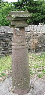 | Anglo-Scandinavian high cross known as the Shall Cross [8] | Cross | Whaley Bridge SK0163579639 | 9th- or 10th-century gritstone cross. A sundial was installed on the shaft in the 18th or 19th century, in place of the original cross head. |
 | Anthony Hill bowl barrow [9] | Barrow | Buxton SK0465370662 | A partial excavation by Thomas Bateman in 1851 revealed a boar's tusk and scattered human bone. The appearance and location indicate that it dates to the Bronze Age. |
| 2 bowl barrows on Withery Low [10] [11] | Barrow | Wormhill SK1022876519 SK1016576498 | ||
| 2 bowl barrows on Bole Hill [12] [13] | Barrow | Wormhill SK1071575692 SK1063075554 | ||
| Bronze Age field system [14] | Field system | Bamford SK2077086292 | 400m south-east of Ladybower Inn | |
 | Bugsworth canal basin, tramway, quarry and limekilns [15] | Quarrying | Buxworth SK0245282063 | |
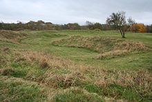 | Bull Ring henge, oval barrow and bowl barrow [16] | Henge | Dove Holes SK0784678237 | Neolithic circular earthwork about 50m across. It has a central flat area surrounded by a ditch and a bank. There are also two burial mounds about 20m from the henge. |
| Cairn near Howden Reservoir Dam [17] | Cairns | Derwent SK1692091891 | 550m south of Howden Reservoir dam wall; submerged when the reservoir is full. | |
| Cairn on Bamford Edge, near Mooredge [18] | Cairns | Bamford SK2084284857 | 500m NE of Mooredge | |
| Cairn on Bamford Edge, near Clough House [19] | Cairns | Bamford SK2136984350 | 570m NE of Clough House | |
| Cairn on Bamford Moor, near Great Tor [20] | Cairns | Bamford SK2139084775 | 500m East of Great Tor | |
| Cairn on Bamford Moor, near High Lees Farm [21] | Cairns | Bamford SK2153184424 | 680m North of High Lees Farm | |
| Cairn on Bamford Moor, near Crow Chin [22] | Cairns | Bamford SK2161585859 | 850m NW of Crow Chin | |
| 2 Cairns on Bamford Moor, near Clough House [20] | Cairns | Bamford SK2139084775 SK2139084775 | 960m and 975m NE of Clough House | |
 | Cairn on Ludworth Intakes [23] | Cairns | Ludworth, near Stockport SJ9898091310 | |
| 2 Cairnfields near High Lees Farm [24] [25] | Cairns | Bamford SK2174684322 SK2192984422 | 600m and 775m NNE of High Lees Farm | |
| Cairnfield near Ladybower Inn [26] | Cairns | Bamford SK2071685856 | 710m and 840m SE of Ladybower Inn | |
| Cairnfield and quarry on Bamford Edge [27] | Cairns | Bamford SK2109484582 | 720m North of Clough House | |
| Coalpithole Rake [28] | Mining | Perryfoot near Sparrowpit SK0989781114 | ||
 | Cow Low bowl barrow [29] | Barrow | Chapel-en-le-Frith SK0653778665 | |
| Cow Low bowl barrow (Tunstead Quarry) [30] | Barrow | Buxton SK1027472976 | A sub-circular Bronze Age burial mound 29m by 25m and 1.7m high. During excavations in 1846, Thomas Bateman discovered several crouched skeletons, jet necklaces, a hexagonal cist and evidence of burials up to c.AD700. | |
 | Cowdale Quarry limestone extraction and processing site [31] | Quarrying | King Sterndale, Buxton SK0791672480 | A lime extraction plant since the late 19th century. The quarry operated its traditional, coal-fired kilns until its closure in 1954. 540m NE of Staden Manor. |
| Crookstone Hill round cairn [32] | Cairns | Hope SK1489788197 | ||
 | Cup-marked stone [33] | Stone | Chisworth SK0069290942 | 80m East of Robin Hood's Picking Rods |
 | Eldon Hill bowl barrow [34] | Barrow | Peak Forest SK1155881147 | Bronze Age burial mound with a recent summit cairn above. Excavations in the 1860s and 1870s found several human skeletons in a tomb with stone structures. |
 | Eldon Hill crushing circle, associated lead mining remains and palisaded enclosure [35] | Mining | Peak Forest SK1175581132 | 7m wide crushing circle with remnants of paving and central edge runner stone. The site also includes remains of shafts and a stone shed. Site of mining of a lead ore vein called Burning Drake Vein. |
| Engine Sough and associated nucleated lead mine [36] | Mining | Castleton SK1274383253 | 500m South of Mam Tor | |
| Fox Low bowl barrow [37] | Barrow | Buxton SK0672971236 | A sub-circular cairn 16m by 14.5m and c.1.5m high. Partially excavated by Thomas Bateman in 1850 and found to contain human remains. The appearance and location indicate it to be of the Bronze Age. | |
| Gautries Hill bowl barrow [38] | Barrow | Peak Forest SK0987180982 | ||
 | Gautries Rake [39] | Mining | Peak Forest SK1009980821 | |
 | Green Low ringcairn [40] | Cairns | Chapel-en-le-Frith SK0840482989 | |
| Harrod Low long barrow [41] | Barrow | Peak Forest SK0984480592 | ||
| Hill's Venture lead mine [42] | Mining | Peak Forest SK1243379278 | ||
| Hollins Hill bowl barrow [43] | Barrow | Hartington SK0604067909 | ||
 | Hope Motte [44] | Fort | Hope SK1715383433 | |
 | Hordron Edge stone circle [45] | Henge | Derwent SK2152486851 | 540m SE of Cutthroat Bridge |
| How Grove Lead Mine [46] | Mining | Castleton SK1484681785 | ||
 | Kinderlow bowl barrow [47] | Barrow | Hayfield SK0732486665 | |
 | Lady Low barrow [48] | Barrow | Chapel-en-le-Frith SK0653278188 | |
 | Lismore Fields Mesolithic and Neolithic settlement [49] | Settlement | Buxton SK0498473218 | The first inhabitants of Buxton made their home at Lismore Fields 6,000 years ago. The Stone Age settlement was discovered in 1984 with remains of a Mesolithic timber roundhouse, Neolithic longhouses and one of the oldest pots ever found in Britain. Lismore Fields could be the earliest cereal cultivation site discovered in Britain. [50] |
 | Lord's Seat bowl barrow [51] | Barrow | Edale SK1124983461 | |
 | Market cross [52] | Cross | Chapel-en-le-Frith SK0570880703 | Also a Grade II listed building. [53] |
| Medieval hospital [54] | Hospital | Castleton SK1554783329 | 530m SE of Losehill Hall | |
 | Melandra Castle (Ardotalia) Roman fort [55] | Fort | Glossop SK0093595049 | Ardotalia (also known as Melandra, or Melandra Castle) is a Roman fort in Gamesley, near Glossop. |
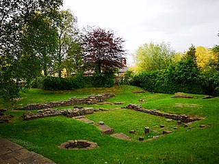
 | Navio Roman Fort and vicus [56] | Fort | Brough-on-Noe near Hope SK1818682692 | Originally built of timber and earthworks around 100 BC. It was rebuilt in stone around 150BC and was in use until around 350 AD. The site now consists of earthwork banks and ditches around an earthen platform, buried remains and a few exposed stone slabs. Excavations in 1903 revealed an underground chamber of the Principia or headquarters building. |
| New Rake lead mines [57] | Mining | Castleton SK1376482034 | 600m SE of Rowter Farm | |
 | Odin Mine nucleated lead mine and ore works [58] | Mining | Castleton SK1341283493 | The oldest documented mine in Derbyshire and thought to be one of the oldest lead mines in England. 350m WNW of Knowlegates Farm. |
| Oval Cairn at Gospel Hillocks, Cowdale [59] | Cairns | King Sterndale, Buxton SK0862771485 | One of two cairns lying c.100m apart. Measuring 28m x 18.5m and now less than 1m high. Neolithic in shape and 19th-century excavations found a polished flint axe, buried human remains on a limestone slab and several jet buttons. A stone cist contained two further burials, fragments of Beaker pottery and flint flakes, suggesting reuse of the cairn into the early Bronze Age. | |
 | Ox Low oval barrow [60] | Barrow | Peak Forest SK1300380542 | |
 | Oxlow Rake lead mines [61] | Mining | Castleton SK1285780329 | |
| Palisaded hilltop enclosure [62] | Enclosure | Castleton SK1561182072 | 230m SSE of Dirt Low | |
| Part of Goyt's Moss colliery [63] | Mining | Buxton SK0145571773 | Centered 220m south west of Derbyshire Bridge | |
| Peakshill or Oden sough [64] | Mining | Peak Forest SK1172382953 | ||
 | Perry Dale bowl barrow and long barrow [65] | Barrow | Peak Forest SK1091981183 | |
 | Peveril Castle eleventh to fourteenth century tower keep castle [66] | Castle | Castleton SK1485382540 | A ruined 11th-century castle overlooking the village of Castleton. It was the main settlement of William Peverel. Also a Grade I listed building. [67] |
| Pike Low bowl barrow [68] | Barrow | Derwent SK1803189747 | ||
| Pin Dale lead side veins [69] | Mining | Castleton SK1582282340 | ||
| Prehistoric standing stone [70] | Stone | Bamford SK2201284694 | 1 km SW of triangulation point on High Neb | |
 | Promontory fort on Combs Edge [71] | Fort | Chapel-en-le-Frith SK0536478410 | Castle Naze Iron Age hillfort on Combs Moss |
 | Reconstructed packhorse bridge from Derwent Hall [72] [73] | Bridge | Bamford, Hope Valley SK1692295123 | When Ladybower Reservoir was built, Derwent's packhorse bridge, spanning the River Derwent near the main gates of Derwent Hall, was removed stone by stone and rebuilt at Slippery Stones, at the head of Howden Reservoir. Also a Grade II listed building. [74] |
| Ring cairn on Bamford Moor [75] | Cairns | Bamford SK2088585254 | 900m NE of Lydgate Farm | |
| Ringwork in Castlehill Wood [76] | Earthwork | Glossop SK0281195507 | ||
| Roman fortlet [77] | Fort | Tintwistle SK0642899012 | 320m East of Highstones | |
| Romano-British farmstead [78] | Settlement | Bamford SK2091486576 | 475m East of Ladybower Inn | |
| Romano-British farmstead and post-medieval charcoal burning site [79] | Settlement | Derwent SK2089886884 | 570m NE of Ladybower Inn | |
| Round barrow [80] | Barrow | Castleton | 500m SW of Peveril Castle SK1470982218 | |
| Round cairn near Crookhill Farm [81] | Cairns | Hope Woodlands SK1824786951 | 430m West of Crookhill Farm | |
| Round cairn and clearance cairn [82] | Cairns | Hope Woodlands SK1794487116 | 770m NW of Crookhill Farm | |
| Round cairn at Gospel Hillocks, Cowdale [83] | Cairns | King Sterndale, Buxton SK0870671575 | One of two cairns lying c.100m apart, measuring 14m x 13m and c.1m high. It was opened in 1896 and found to contain a pit under a large slab with a crouched body covered with a mixture of clay, leaves and charcoal (associated with burnt bones). | |
| Round cairn between Coombes Edge and Cown Edge [84] | Cairns | Charlesworth SK0204591892 | ||
| 2 Round cairns on Bridge-end Pasture [85] [86] | Cairns | Hope Woodlands SK1728687724 SK1764587742 | 300m and 600m NE of Two Thorne Fields Farm | |
 | Slight univallate hillfort and two bowl barrows on Mam Tor [87] | Fort | Castleton SK1276183716 | |
| Slitherstone and Linacre lead mines and a limekiln [88] | Mining | Castleton SK1265981570 | 725m SW of Rowter Farm | |
| Snelslow Plantation bowl barrow [89] | Barrow | Peak Forest SK1188979424 | ||
 | Staden Low earthwork [90] | Earthwork | Staden, Buxton SK0690672116 | A circular Neolithic earthwork excavated in 1926 by Mr R Woolescroft, who discovered a stone axe head, flint artefacts, pottery fragments and pieces of deer antler. [91] |
 | Standing cross in the churchyard of St Peter's Church, Hope [92] | Cross | Hope SK1723883439 | |
 | Standing cross in the churchyard of St Thomas Becket Church [93] | Cross | Chapel-en-le-Frith SK0575880808 | |
| Stone circle near Crookhill Farm [94] | Henge | Hope Woodlands SK1847187113 | 330m NW of Crookhill Farm | |
| The Folly platform cairn [95] | Cairns | Hope SK1681982891 | ||
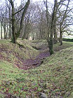
 | The Grey Ditch [96] | Earthwork | Brough and Shatton SK1684381835 | |
| The Tong bowl barrow and long barrow [97] | Barrow | Wormhill SK1169376993 | ||
 | Town defences [98] | Defences | Castleton SK1495782991 | 13th-century earthwork bank and ditch remains 270m north and 350m north-east of Peveril Castle |
| Two hlaews at Haslin House [99] | Burial mound | Buxton SK0625170540 | Pre-Christian burial mounds from the 7th century AD. The northernmost is 14m by 13m and 0.7m high and was partially excavated in 1850 by Thomas Bateman. It contained a small central cairn over a rock-cut grave, with human remains buried in a wooden coffin or surrounded by wooden planks. | |
 | Watt's Grove Rake lead mines [100] | Mining | Peak Forest SK1169380661 | 520m north of Sweetknoll |
 | Wayside and a boundary cross known as Robin Hood's Picking Rods [101] | Cross | Chisworth SK0061290938 | |
 | Wayside and boundary cross known as Edale Cross [102] | Cross | Hayfield SK0771786099 | |
 | Wayside and boundary cross known as The Dipping Stone [103] | Cross | Whaley Bridge SJ9955681714 | |
 | Wayside cross known as Eccles Cross [104] | Cross | Hope SK1723183480 | The 13th-century cross was moved to St Peter's churchyard in 1966 from higher ground c.500m away by the lane to Eccles House Farm. |
 | Wind Low bowl barrow and standing cross [105] | Cross | Wormhill SK1143575162 | Base of a medieval standing cross and barrow mound 16m by 12m. Excavation by Thomas Bateman in 1846 found Bronze-Age human remains, jewellery & pottery fragments. |