List of scheduled monuments in Sedgemoor

Last updated

Sedgemoor shown within Somerset and England Sedgemoor UK locator map.svg
Sedgemoor shown within Somerset and England

Sedgemoor is a low-lying area of land in Somerset, England. It lies close to sea level south of the Polden Hills, forming a large part of the Somerset Levels and Moors, a wetland area between the Mendips and the Blackdown Hills. [1] The Neolithic people exploited the reed swamps for their natural resources and started to construct wooden trackways, including the world's oldest known timber trackway, the Post Track, dating to the 3800s BC. [2] The Levels were the location of the Iron Age Glastonbury Lake Village as well as two lake villages at Meare Lake. [3] [4] Several settlements and hill forts were built on the natural "islands" of slightly raised land, including Brent Knoll and Glastonbury. [5] [6] In the Roman period sea salt was extracted and a string of settlements were set up along the Polden Hills. [7]

Contents

A scheduled monument is a nationally important archaeological site or monument which is given legal protection by being placed on a list (or "schedule") by the Secretary of State for Culture, Media and Sport; English Heritage takes the leading role in identifying such sites. The legislation governing this is the Ancient Monuments and Archaeological Areas Act 1979. The term "monument" can apply to the whole range of archaeological sites, and they are not always visible above ground. Such sites have to have been deliberately constructed by human activity. They range from prehistoric standing stones and burial sites, through Roman remains and medieval structures such as castles and monasteries, to later structures such as industrial sites and buildings constructed for the World Wars or the Cold War. [8]

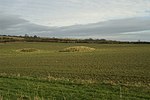
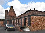
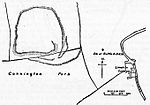
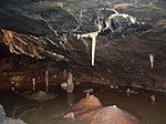
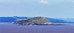
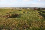
There are 79 scheduled monuments in Sedgemoor. The oldest are Neolithic, Bronze Age or Iron Age including hill forts, bowl barrows and occupied caves including several in Cheddar Gorge. Cannington Camp (which is also known as Cynwit Castle) dates from the Bronze Age, [9] while Brent Knoll Camp between the Somerset Levels and Brean Down is Iron Age (although there are some Bronze Age artefacts) and it was reused in the Roman period. [10] [11] The Romano-British period is represented with several sites. Medieval sites include several motte-and-bailey castles and church or village crosses. Industrial development, particularly in Bridgwater, are represented by brick and tile kilns and a telescopic railway bridge. [12] [13] The most recent monuments are World War II bunkers and bombing decoys on Black Down. The monuments are listed below using the titles given in the English Heritage data sheets.

Monuments

See also

Notes

  1. The date given is the date used by Historic England as significant for the initial building or that of an important part in the structure's description.
  2. Sometimes known as OSGB36, the grid reference is based on the British national grid reference system used by the Ordnance Survey.
  3. The "List Entry Number" is a unique number assigned to each listed building and scheduled monument by Historic England.

Related Research Articles

<span class="mw-page-title-main">Dunkery Hill</span> Summit of Dunkery Hill

Dunkery Beacon at the summit of Dunkery Hill is the highest point on Exmoor and in Somerset, England. It is also the highest point in southern England outside of Dartmoor.

<span class="mw-page-title-main">Priddy Circles</span>

Priddy Circles are a linear arrangement of four circular earthwork enclosures near the village of Priddy on the Mendip Hills in Somerset, England. The circles have been listed as Scheduled Ancient Monuments, and described as 'probable Neolithic ritual or ceremonial monuments similar to a henge'.

<span class="mw-page-title-main">Sand Point and Middle Hope</span> Headland in Somerset, England

Sand Point in Somerset, England, is the peninsula stretching out from Middle Hope, an 84.1-hectare (208-acre) biological and geological Site of Special Scientific Interest. It lies to the north of the village of Kewstoke, and the stretch of coastline called Sand Bay north of the town of Weston-super-Mare. On a clear day it commands views over Flat Holm, of the Bristol Channel, South Wales, Clevedon, the Second Severn Crossing and the Severn Bridge. A line drawn between Sand Point and Lavernock Point in South Wales marks the lower limit of the Severn Estuary and the start of the Bristol Channel.

<span class="mw-page-title-main">Priddy Nine Barrows and Ashen Hill Barrow Cemeteries</span>

Priddy Nine Barrows Cemetery and Ashen Hill Barrow Cemetery are a collection of round barrows, dating from the Bronze Age, near Priddy in the English county of Somerset. They are designated as ancient monuments.

<span class="mw-page-title-main">Scheduled monuments in Bath and North East Somerset</span>

Bath and North East Somerset is a unitary authority created on 1 April 1996, following the abolition of the County of Avon, which had existed since 1974. Part of the ceremonial county of Somerset, Bath and North East Somerset occupies an area of 220 square miles (570 km2), two-thirds of which is green belt. It stretches from the outskirts of Bristol, south into the Mendip Hills and east to the southern Cotswold Hills and Wiltshire border. The city of Bath is the principal settlement in the district, but BANES also covers Keynsham, Midsomer Norton, Radstock and the Chew Valley. The area has a population of 170,000, about half of whom live in Bath, making it 12 times more densely populated than the rest of the area.

<span class="mw-page-title-main">Scheduled monuments in Taunton Deane</span>

Taunton Deane was a local government district with borough status in Somerset, England. It merged with West Somerset to form Somerset West and Taunton on 1 April 2019. Its council was based in Taunton. The district was formed on 1 April 1974, under the Local Government Act 1972, by a merger of the Municipal Borough of Taunton, Wellington Urban District, Taunton Rural District, and Wellington Rural District. Taunton Deane was granted borough status in 1975, enabling the mayoralty of Taunton to be continued, when other districts did not have mayors. The district was given the name of an alternate form of the Taunton Deane Hundred.

<span class="mw-page-title-main">Scheduled monuments in Mendip</span>

Mendip is a local government district of Somerset in England. The Mendip district covers a largely rural area of 285 square miles (738 km2) ranging from the Mendip Hills through on to the Somerset Levels. It has a population of approximately 110,000. The administrative centre of the district is Shepton Mallet but the largest town is Frome.

<span class="mw-page-title-main">Scheduled monuments in Somerset</span> Nationally important sites in Somerset, England

There are over 670 scheduled monuments in the ceremonial county of Somerset in South West England. The county consists of a non-metropolitan county, administered by Somerset Council. The two administratively independent unitary authorities, which were established on 1 April 1996 following the breakup of the county of Avon, are North Somerset and Bath and North East Somerset. These unitary authorities include areas that were once part of Somerset before the creation of Avon in 1974.

<span class="mw-page-title-main">Robin Hood's Butts</span>

Robin Hood's Butts are a group of nine Bronze Age barrows near Otterford on the Blackdown Hills in Somerset, England. They have been scheduled as ancient monuments.

West Somerset was a local government district in the English county of Somerset. It merged with Taunton Deane to form Somerset West and Taunton on 1 April 2019.

West Somerset was a local government district located in the English county of Somerset. It merged with Taunton Deane to form Somerset West and Taunton on 1 April 2019.

References

  1. Robert Dunning, ed. (2004). "Introduction". A History of the County of Somerset: Volume 8: The Poldens and the Levels. Institute of Historical Research. Retrieved 1 August 2011.
  2. Brunning, Richard (2006). "A window on the past - The prehistoric archaeology of the Somerset Moors". In Hill-Cottingham, Pat; Briggs, Derek; Brunning, Richard; King, Andy; Rix, Graham (eds.). The Somerset Wetlands: An ever changing environment. Wellington, Somerset: Somerset Books. pp. 40–41. ISBN   978-0-86183-432-7.
  3. Historic England. "Glastonbury Lake Village (194156)". Research records (formerly PastScape). Retrieved 16 March 2011.
  4. Historic England. "Meare Lake Villages (194185)". Research records (formerly PastScape). Retrieved 24 March 2011.
  5. Brunning, Richard (2006). Wet and Wonderful: The Heritage of the Avalon Marshes. Somerset Heritage Service. pp. 1–3. ISBN   978-0861833801.
  6. Minnitt, Stephen; Coles, John (2006). The Lake Villages of Somerset. Glastonbury Antiquarian Society. p. 7. ISBN   978-0950712239.
  7. Gathercole, Clare. "Burnham on Sea and Highbridge" (PDF). Archaeological Assessments. South West Heritage Trust. p. 7. Archived from the original (PDF) on 17 July 2011. Retrieved 3 January 2011.
  8. "Scheduled Monuments". English Heritage. Retrieved 9 September 2014.
  9. Historic England. "Cannington Park Camp (191244)". Research records (formerly PastScape). Retrieved 16 March 2011.
  10. Adkins, Lesley and Roy (1992). A field Guide to Somerset Archaeology. Dovecote press. pp. 29–30. ISBN   0-946159-94-7.
  11. "Brent Knoll hill fort, Brent Knoll". Somerset Historic Environment Record. South West Heritage Trust. Retrieved 19 January 2011.
  12. Historic England. "Brick kiln East Quay (1206110)". National Heritage List for England . Retrieved 30 October 2007.
  13. Otter, R. A. (1994). Civil Engineering Heritage: Southern England. Thomas Telford. pp. 95–97. ISBN   0-7277-1971-8.
  14. Historic England. "Alstone lake settlement site (1012311)". National Heritage List for England . Retrieved 6 December 2014.
  15. "The abbey of Athelney". British History Online. Retrieved 12 August 2008.
  16. Havinden, Michael (1981). The Somerset Landscape. The making of the English landscape. London: Hodder and Stoughton. p. 94. ISBN   0-340-20116-9.
  17. "Athelney Abbey". Somerset Historic Environment Record. South West Heritage Trust. Retrieved 12 August 2008.
  18. Historic England. "King Alfred's Monument with railings (1173838)". National Heritage List for England. Retrieved 9 February 2007.
  19. "King Alfred's Monument". Listed Buildings Online. English Heritage. Retrieved 2 January 2011.
  20. Historic England. "Anglo-Saxon burh at East Lyng (1019100)". National Heritage List for England. Retrieved 6 December 2014.
  21. Williams, Michael (2009). The Draining of the Somerset Levels. CUP Archive. p. 60. ISBN   978-0521106856.
  22. Historic England. "Balt Moor Wall (1018952)". National Heritage List for England. Retrieved 15 November 2014.
  23. "Balt Moor Wall, between East Lyng and Athelney, Lyng". Somerset Historic Environment Record. South West Heritage Trust. Retrieved 15 November 2014.
  24. Historic England. "Bath Moor Wall (191938)". Research records (formerly PastScape). Retrieved 15 November 2014.
  25. Historic England. "Barrow at Wilmot's Pool and a cairn 45 m to the north (1417361)". National Heritage List for England. Retrieved 6 December 2014.
  26. "Blackford Manor House Moat, Blackford". Somerset Historic Environment Record. South West Heritage Trust. Retrieved 6 December 2014.
  27. Historic England. "Bowl barrow 75 m south west of Long House Barn (1014712)". National Heritage List for England. Retrieved 6 December 2014.
  28. Historic England. "Bowl barrow 91 m south of Piney Sleight Farm (1010922)". National Heritage List for England. Retrieved 6 December 2014.
  29. Historic England. "Bowl barrow 190 m south west of Tyning's Farm: part of the Tyning's Farm round barrow cemetery (1012593)". National Heritage List for England. Retrieved 6 December 2014.
  30. Historic England. "Bowl barrow 250 m south east of Tyning's Farm: part of the Tyning's Farm round barrow cemetery (1015815)". National Heritage List for England. Retrieved 6 December 2014.
  31. Historic England. "Bowl barrow 250 m south west of Ashridge Farm (1012592)". National Heritage List for England. Retrieved 6 December 2014.
  32. Historic England. "Bowl barrow 300 m east of Batts Coombe Quarry (1010800)". National Heritage List for England. Retrieved 6 December 2014.
  33. Historic England. "Bowl barrow 300m north east of Tyning's Farm (1011584)". National Heritage List for England. Retrieved 23 February 2015.
  34. Historic England. "Bowl barrow 300 m north east of Tyning's Farm (1011584)". National Heritage List for England. Retrieved 6 December 2014.
  35. Historic England. "Bowl barrow 350 m east of Batts Coombe Quarry (1010921)". National Heritage List for England. Retrieved 6 December 2014.
  36. Historic England. "Bowl barrow 400 m southeast of Wellington Farm (1011533)". National Heritage List for England. Retrieved 6 December 2014.
  37. Adkins, Lesley and Roy (1992). A field Guide to Somerset Archeology. Stanbridge: Dovecote press. pp. 29–30. ISBN   0-946159-94-7.
  38. "Brent Knoll hillfort, Brent Knoll". Somerset Historic Environment Record. South West Heritage Trust. Retrieved 19 January 2011.
  39. Historic England. "Brick kiln East Quay (1206110)". National Heritage List for England. Retrieved 30 October 2007.
  40. Historic England. "Brick and tile kiln west of East Quay, 200 m east of Bridgwater Dock lock (1019900)". National Heritage List for England. Retrieved 6 December 2014.
  41. "Somerset Brick and Tile Museum". South West Heritage Trust. Archived from the original on 8 December 2014. Retrieved 6 December 2014.
  42. Historic England. "Bronze Age and Iron Age trackways 600 m north east of Northbrook Farm (1014444)". National Heritage List for England. Retrieved 12 December 2014.
  43. Historic England. "Bronze Age and Iron Age timber trackways, 700 m north west of Coppice Gate Farm (1014431)". National Heritage List for England. Retrieved 12 December 2014.
  44. Historic England. "Cairn 500 m north west of Quantock Farm (1019801)". National Heritage List for England. Retrieved 12 December 2014.
  45. Historic England. "Chandos Glass Cone, at the junction of Northgate and Valetta Place (1019899)". National Heritage List for England. Retrieved 12 December 2014.
  46. Historic England. "Adscombe Chapel (189492)". Research records (formerly PastScape). Retrieved 27 September 2014.
  47. "Chapel, E of Adscombe Farm, Adscombe". Somerset Historic Environment Record. South West Heritage Trust. Retrieved 12 December 2014.
  48. Historic England. "Churchyard cross in St George's churchyard (1015454)". National Heritage List for England. Retrieved 12 December 2014.
  49. Historic England. "Churchyard cross in St Mary the Virgin's churchyard (1015455)". National Heritage List for England. Retrieved 12 December 2014.
  50. Historic England. "Churchyard cross in All Saints' churchyard (1015456)". National Heritage List for England. Retrieved 12 December 2014.
  51. Historic England. "Churchyard cross in St Michael's churchyard (1015457)". National Heritage List for England. Retrieved 12 December 2014.
  52. Historic England. "Churchyard cross in St Margaret's churchyard (1015458)". National Heritage List for England. Retrieved 12 December 2014.
  53. Historic England. "Churchyard cross in St Mary's churchyard (1015452)". National Heritage List for England. Retrieved 12 December 2014.
  54. Historic England. "Churchyard cross 5.6 m south east of the porch of St Martin's Church (1015453)". National Heritage List for England. Retrieved 12 December 2014.
  55. Historic England. "Cannington Park Camp (191244)". Research records (formerly PastScape). Retrieved 16 March 2011.
  56. "Cynwit Hillfort (Cannington Camp)". Digital Digging. 25 November 2013. Retrieved 7 January 2015.
  57. Historic England. "Dead Woman's Ditch cross-dyke, Robin Upright's Hill (1008254)". National Heritage List for England. Retrieved 12 December 2014.
  58. Historic England. "Duck decoy, west of Nyland Hill (1014452)". National Heritage List for England. Retrieved 12 December 2014.
  59. "Duck decoy pool, Decoy rhyne, Cossington". Somerset Historic Environment Record. South West Heritage Trust. Retrieved 27 September 2014.
  60. Historic England. "Monument No. 1044765". Research records (formerly PastScape). Retrieved 27 September 2014.
  61. Historic England. "Duck decoy 175 m south west of Parson's Farm (1014445)". National Heritage List for England. Retrieved 12 December 2014.
  62. Historic England. "Gorsey Bigbury (194311)". Research records (formerly PastScape). Retrieved 27 September 2014.
  63. "Barrow, Long Wood, Cheddar". Somerset Historic Environment Record. South West Heritage Trust.
  64. Apsimon, A.M.; Musgrave, J.H.; Sheldon, J.; Tratman, E.K.; Van Wijngaarden-Bakker, L.H. (1976). "Gorsey Bigbury, Cheddar, Somerset" (PDF). Proceedings of the University of Bristol Spelaeoligal Society. 14 (2): 155–183.
  65. "Gough's Cave excavation site". Natural History Museum. Archived from the original on 2 April 2015. Retrieved 6 March 2015.
  66. "Mendip". UK and Ireland Cave Lengths and Depths. Retrieved 15 January 2007.
  67. Bello, Silvia M.; Parfitt, Simon A.; Stringer, Chris B. (2011). "Earliest Directly-Dated Human Skull-Cups". PLOS ONE. 6 (2): e17026. Bibcode:2011PLoSO...617026B. doi: 10.1371/journal.pone.0017026 . PMC   3040189 . PMID   21359211.
  68. Historic England. "Gough's Old Cave (1012064)". National Heritage List for England. Retrieved 13 December 2014.
  69. Historic England. "Great Oone's Hole (1010906)". National Heritage List for England. Retrieved 13 December 2014.
  70. Historic England. "Group of three bowl barrows 180 m south of Tyning's Farm: part of the Tyning's Farm round barrow cemetery (1012594)". National Heritage List for England. Retrieved 13 December 2014.
  71. Historic England. "Group of three bowl barrows 180 m south of Tyning's Farm: part of the Tyning's Farm round barrow cemetery (1020438)". National Heritage List for England. Retrieved 13 December 2014.
  72. "Longbottom Camp, 100 m NW of Longbottom Farm, Shipham". Somerset Historic Environment Record. South West Heritage Trust. Retrieved 27 September 2014.
  73. "Abandoned settlement, Mudgley 11235 Mudgley Ancient Mediaeval Village & Earthworks". 466 AD. Archived from the original on 27 September 2014. Retrieved 27 September 2014.
  74. HUdson, Hazel. "The Search for King Alfred's Palace at Mudgley". Theale. Retrieved 27 September 2014.
  75. "Mudgley Manor House, Court Garden, Mudgley". Somerset Historic Environment Record. South West Heritage Trust. Retrieved 13 December 2014.
  76. Historic England. "Market Cross (1173642)". National Heritage List for England. Retrieved 13 July 2013.
  77. Historic England. "Medieval estate boundary earthwork on Shute Shelve Hill (1015495)". National Heritage List for England. Retrieved 13 December 2014.
  78. Historic England. "Medieval settlement 160 m south and 240 m south west of Sandford Farm (1020016)". National Heritage List for England. Retrieved 13 December 2014.
  79. Historic England. "Edithmead (192231)". Research records (formerly PastScape). Retrieved 27 September 2014.
  80. "Moated site, Edithmead". Somerset Historic Environment Record. South West Heritage Trust. Retrieved 27 September 2014.
  81. "Chisley Mount, Down End". Castle Facts. Retrieved 7 January 2015.
  82. Historic England. "Down End earthworks (192333)". Research records (formerly PastScape). Retrieved 23 July 2011.
  83. "Motte and Bailey castle, Down End". Somerset Historic Environment Record. South West Heritage Trust. Retrieved 23 July 2011.
  84. Prior, Stuart (2006). A Few Well-Positioned Castles: The Norman Art of War. The History Press. pp. 88–89. ISBN   978-0752436517.
  85. Historic England. "Multi-period site on Brean Down (1008211)". National Heritage List for England. Retrieved 7 June 2014.
  86. "Hillfort, Brean Down". Somerset Historic Environment Record. South West Heritage Trust. Retrieved 7 July 2011.
  87. van der Bijl, Nicholas (2000). Brean Down Fort: Its History and the Defences of the Bristol Channel. Cossington: Hawk Editions. pp. 119–123. ISBN   978-0-9529081-7-3.
  88. Historic England. "Multi-period site on Brean Down (1008211)". National Heritage List for England. Retrieved 7 June 2014.
  89. Historic England. "Picken's Hole (1010715)". National Heritage List for England. Retrieved 13 December 2014.
  90. Pettitt, Paul; White, Mark (2012). The British Palaeolithic: Human Societies at the Edge of the Pleistocene World. Abingdon, UK: Routledge. pp. 364–65. ISBN   978-0-415-67455-3.
  91. Historic England. "Plainsfield Camp slight univallate hillfort (1007669)". National Heritage List for England. Retrieved 24 August 2014.
  92. Historic England. "Platform cairn, 180 m east of Wilmot's Pool (1417363)". National Heritage List for England. Retrieved 13 December 2014.
  93. Historic England. "Prehistoric timber trackways, 670 m SSE of Parchey Bridge (1014430)". National Heritage List for England. Retrieved 13 December 2014.
  94. Robert Dunning, ed. (2004). "Edington". A History of the County of Somerset: Volume 8: The Poldens and the Levels. Institute of Historical Research. Retrieved 28 September 2014.
  95. "Roman briquetage mounds, Burtle Moor, Burtle". Somerset Heritage. South West Heritage Trust. Archived from the original on 28 September 2014. Retrieved 28 September 2014.
  96. Emery, Anthony (2007). Discovering Medieval Houses. Osprey Publishing. p. 21. ISBN   9780747806554.
  97. Historic England. "Roman settlement site, Anglo-Saxon and Norman royal palace, and St Columbanus' Chapel (1017290)". National Heritage List for England. Retrieved 26 May 2014.
  98. Historic England. "Romano-British settlement on Stoke Moor (1011125)". National Heritage List for England. Retrieved 14 December 2014.
  99. Historic England. "Monument No. 194358". Research records (formerly PastScape). Retrieved 24 February 2015.
  100. Historic England. "Monument No. 194352". Research records (formerly PastScape). Retrieved 24 February 2015.
  101. Historic England. "Rowberrow Cavern, Mendip Forest (1011926)". National Heritage List for England. Retrieved 14 December 2014.
  102. Historic England. "Rowberrow Camp: an Iron Age defended settlement north west of Tynings Farm (1008806)". National Heritage List for England. Retrieved 14 December 2014.
  103. "Ruborough Camp large univallate hillfort, Broomfield — Sedgemoor". Heritage at Risk. English Heritage. Retrieved 28 October 2015.
  104. Waite, Vincent (1964). Portrait of the Quantocks. London: Robert Hale. ISBN   0-7091-1158-4.
  105. Historic England. "Saye's Hole, Cheddar Gorge (1011916)". National Heritage List for England. Retrieved 5 January 2015.
  106. Historic England. "Sections of the Sweet Track and Post Track, 650 m east of Canada Farm (1014439)". National Heritage List for England. Retrieved 5 January 2015.
  107. Historic England. "Soldier's Hole, Cheddar Gorge (1011914)". National Heritage List for England. Retrieved 5 January 2015.
  108. Historic England. "Sections of the Sweet Track, the Post Track and associated remains 500 m north east of Moorgate Farm (1014438)". National Heritage List for England. Retrieved 5 January 2015.
  109. Historic England. "Monument No. 191284". Research records (formerly PastScape). Retrieved 5 January 2015.
  110. Historic England. "Star Roman villa, 275 m north east of Wimblestone (1015499)". National Heritage List for England. Retrieved 5 January 2015.
  111. Historic England. "Stowey Castle (189462)". Research records (formerly PastScape). Retrieved 24 July 2011.
  112. "Nether Stowey". Quantock Online. Retrieved 10 March 2008.
  113. Historic England. "Sun Hole, Cheddar Gorge (1011915)". National Heritage List for England. Retrieved 5 January 2015.
  114. Otter, R. A. (1994). Civil Engineering Heritage: Southern England. Thomas Telford. ISBN   0-7277-1971-8.
  115. "Rail bridge over River Parrett, Bridgwater". Somerset Historic Environment Record. South West Heritage Trust. Retrieved 21 December 2009.
  116. Historic England. "The Chapel (191092)". Research records (formerly PastScape). Retrieved 5 January 2015.
  117. Historic England. "Timber trackways at Moor Drove, 800 m east of Brentsfield Bridge (1014872)". National Heritage List for England. Retrieved 5 January 2015.
  118. Historic England. "Timber trackways 850 m east of Catcott Burtle Farm (1014433)". National Heritage List for England. Retrieved 5 January 2015.
  119. Historic England. "Monument No. 194419". Research records (formerly PastScape). Retrieved 5 January 2015.
  120. Historic England. "Village cross (1015450)". National Heritage List for England. Retrieved 5 January 2015.
  121. Historic England. "Roadside Cross At Ngr St 4248 4966 (1252914)". National Heritage List for England. Retrieved 13 July 2013.
  122. Historic England. "Wimblestone (194539)". Research records (formerly PastScape). Retrieved 5 January 2015.
  123. "Wimblestone Standing Stone, Star". Somerset Historic Environment Record. South West Heritage Trust. Retrieved 5 January 2015.
  124. Historic England. "Wooden trackways on Chilton Moor, 300 m west of Station Farm (1014437)". National Heritage List for England. Retrieved 5 January 2015.
  125. Historic England. "World War II anti-aircraft rocket battery and bombing decoy control building 265 m north east of Ashridge Farm (1020994)". National Heritage List for England. Retrieved 5 January 2015.
  126. Historic England. "World War II bombing decoy complex, anti-aircraft obstructions and Beacon Batch round barrow cemetery on Black Down (1020995)". National Heritage List for England. Retrieved 5 January 2015.