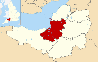
Sedgemoor is a local government district in the English county of Somerset. In the United Kingdom, the term listed building refers to a building or other structure officially designated as being of special architectural, historical or cultural significance; Grade I structures are those considered to be "buildings of exceptional interest". [1] Listing was begun by a provision in the Town and Country Planning Act 1947. Once listed, severe restrictions are imposed on the modifications allowed to a building's structure or its fittings. In England, the authority for listing under the Planning (Listed Buildings and Conservation Areas) Act 1990 [2] rests with Historic England, a non-departmental public body sponsored by the Department for Digital, Culture, Media and Sport; local authorities have a responsibility to regulate and enforce the planning regulations.
Sedgemoor is a low-lying area of land close to sea level between the Quantock and Mendip hills, historically largely marsh (or moor). It contains the bulk of the area also known as the Somerset Levels, including Europe's oldest known engineered roadway, the Sweet Track. [3]
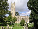
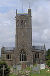
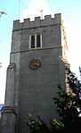
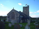
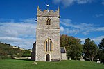
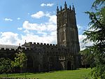
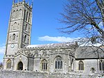
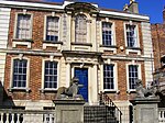
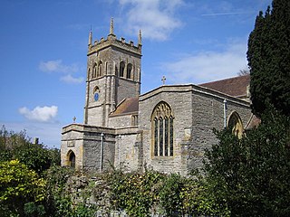
There are 53 Grade I listed buildings in Sedgemoor, 14 of which are in Castle Street, Bridgwater. In 1723–1728, Castle Street was built on the site of the demolished Bridgwater Castle, as homes for the merchants trading in the town's port. Outside the town of Bridgwater, the largest concentration of Grade I listed buildings are in the village of Cannington, where the 12th-century Cannington Court [4] and 14th-century Church of St Mary [5] were both associated with a Benedictine nunnery. Cannington is also the site of the 13th-century Gurney Manor [6] and Blackmoor Farmhouse, which was built around 1480 with its own chapel. [7] Most of the Grade I listed buildings in Sedgemoor are Norman- or medieval-era churches, many of which are included in the Somerset towers, a collection of distinctive, mostly spireless Gothic church towers. Many of the more recent structures in the list are manor houses such as Halswell House, where the south range was built in the 16th century for Sir Nicholas Halswell and the main north range in 1689 for Sir Halswell Tynte. [8] The most recently constructed building in the list is the Corn Exchange in Bridgwater, built in 1834. [9]

Bridgwater is a historic market town and civil parish in Somerset, England. The town had a population of 41,276 at the 2021 Census. Bridgwater is at the edge of the Somerset Levels, in level and well-wooded country. The town lies along both sides of the River Parrett; it has been a major inland port and trading centre since the industrial revolution. Most of its industrial bases still stand today. Its larger neighbour, Taunton, is linked to Bridgwater via a canal, the M5 motorway and the GWR railway line.

Stogursey is a small village and civil parish in the Quantock Hills in Somerset, England. It is situated 3 miles (4.8 km) from Nether Stowey, and 8 miles (12.9 km) west of Bridgwater. The village is situated near the Bristol Channel, which bounds the parish on the north.
Chedzoy is a civil parish village 3 miles (4.8 km) east of Bridgwater in Somerset, England.
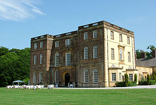
Halswell House is a Grade I listed country house in Goathurst, Somerset, England.
Otterhampton is a village and civil parish in Somerset, England, between Bridgwater and the Steart Peninsula. The civil parish includes the larger village of Combwich and the small village of Steart.
Spaxton is a small village and civil parish on the Quantocks in Somerset, South West England.

Over Stowey is a small village and civil parish in Somerset, South West England. A large part of the forest and open heath of the Quantock Hills is within the parish and it includes the hamlets of Plainsfield, Aley, Adscombe, Friarn and Bincombe. It is adjacent to Nether Stowey, 8 miles (13 km) north-west of Bridgwater.

Cannington is a village and civil parish 3 miles (5 km) northwest of Bridgwater in Somerset, England. It lies on the west bank of the River Parret, and contains the hamlet of Edstock.

Chilton Trinity is a village and civil parish on the River Parrett, 2 miles (3 km) north of Bridgwater in Somerset, England.

The Grade I listed buildings in Somerset, England, demonstrate the history and diversity of its architecture. The ceremonial county of Somerset consists of a non-metropolitan county, administered by Somerset County Council, which is divided into five districts, and two unitary authorities. The districts of Somerset are West Somerset, South Somerset, Taunton Deane, Mendip and Sedgemoor. The two administratively independent unitary authorities, which were established on 1 April 1996 following the breakup of the county of Avon, are North Somerset and Bath and North East Somerset. These unitary authorities include areas that were once part of Somerset before the creation of Avon in 1974.
Mendip is a local government district in the English county of Somerset. The Mendip district covers a largely rural area of 285 square miles (738 km2) ranging from the Mendip Hills through on to the Somerset Levels. It has a population of approximately 11,000. The administrative centre of the district is Shepton Mallet.
Taunton Deane is a local government district with borough status in the English county of Somerset. In the United Kingdom, the term listed building refers to a building or other structure officially designated as being of special architectural, historical or cultural significance; Grade I structures are those considered to be "buildings of exceptional interest". Listing was begun by a provision in the Town and Country Planning Act 1947. Once listed, severe restrictions are imposed on the modifications allowed to a building's structure or its fittings. In England, the authority for listing under the Planning Act 1990 rests with Historic England, a non-departmental public body sponsored by the Department for Digital, Culture, Media and Sport; local authorities have a responsibility to regulate and enforce the planning regulations.
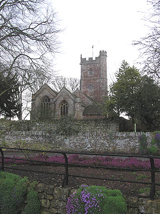
The Church of St Mary is the parish church of Cannington, Somerset, England. The parish is in the Church of England Diocese of Bath and Wells.

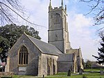
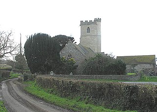
The Church of St Mary at Charlynch in the parish of Spaxton, Somerset, England was an Anglican Parish Church, but has now been deconsecrated. It dates from the 11th century with a tower probably of 1867. It has been designated as a Grade I listed building.

Gothelney Hall, also known as Gothelney Manor Farmhouse, located in the parish of Spaxton, Somerset, England was built in the 15th century and has been designated as a Grade I listed building.

West Somerset is a local government district in the county of Somerset which is in South West England. In the United Kingdom, the term listed building refers to a building or other structure officially designated as being of special architectural, historical or cultural significance; Grade II* structures are those considered to be "particularly significant buildings of more than local interest". Listing was begun by a provision in the Town and Country Planning Act 1947. Once listed, severe restrictions are imposed on the modifications allowed to a building's structure or its fittings. In England, the authority for listing under the Planning Act 1990 rests with Historic England, a non-departmental public body sponsored by the Department for Digital, Culture, Media and Sport; local authorities have a responsibility to regulate and enforce the planning regulations.

Bath and North East Somerset is a unitary authority created on 1 April 1996, following the abolition of the County of Avon, which had existed since 1974. Part of the ceremonial county of Somerset, Bath and North East Somerset occupies an area of 220 square miles (570 km2), two-thirds of which is green belt. It stretches from the outskirts of Bristol, south into the Mendip Hills and east to the southern Cotswold Hills and Wiltshire border. The city of Bath is the principal settlement in the district, but BANES also covers Keynsham, Midsomer Norton, Radstock and the Chew Valley. The area has a population of 170,000, about half of whom live in Bath, making it 12 times more densely populated than the rest of the area.
Sedgemoor is a local government district in the English county of Somerset. In the United Kingdom, the term listed building refers to a building or other structure officially designated as being of special architectural, historical or cultural significance; Grade II* structures are those considered to be "particularly significant buildings of more than local interest". Listing was begun by a provision in the Town and Country Planning Act 1947. Once listed, severe restrictions are imposed on the modifications allowed to a building's structure or its fittings. In England, the authority for listing under the Planning Act 1990 rests with Historic England, a non-departmental public body sponsored by the Department for Digital, Culture, Media and Sport; local authorities have a responsibility to regulate and enforce the planning regulations.

West Bower Manor in Durleigh within the English county of Somerset was largely built in the 15th century. It is a Grade II* listed building.