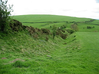
Offa's Dyke is a large linear earthwork that roughly follows the border between England and Wales. The structure is named after Offa, the Anglo-Saxon king of Mercia from AD 757 until 796, who is traditionally believed to have ordered its construction. Although its precise original purpose is debated, it delineated the border between Anglian Mercia and the Welsh kingdom of Powys.

Leicester is a city, unitary authority area, unparished area and the county town of Leicestershire in the East Midlands of England. It is the largest city in the East Midlands. Its population was 368,600 in 2021, increased by 38,800 from around 329,800 in 2011. The greater Leicester urban area had a population of 559,017 in 2021, making it the 11th most populous in England, and the 13th most populous in the United Kingdom.

In the United Kingdom, a scheduled monument is a nationally important archaeological site or historic building, given protection against unauthorised change.

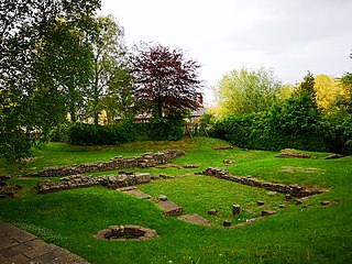
The Jewry Wall is a substantial ruined wall of 2nd-century Roman masonry, with two large archways, in Leicester, England. It stands alongside St Nicholas' Circle and St Nicholas' Church. It formed the west wall of a public building in Ratae Corieltauvorum, alongside public baths, the foundations of which were excavated in the 1930s and are also open to view. The wall gives its name to the adjacent Jewry Wall Museum.

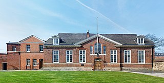
Leicester Castle is in the city of the same name in the English county of Leicestershire. The complex is situated in the west of Leicester City Centre, between Saint Nicholas Circle to the north and De Montfort University to the south. A large motte and the Great Hall are the two substantial remains of what was once a large defensive structure. The hall is now encased in a Queen Anne style frontage. The Castle and the Magazine Gateway is a scheduled monument.

Grim's Ditch, Grim's Dyke or Grim's Bank is a name shared by a number of prehistoric bank and ditch linear earthworks across England. They are of different dates and may have had different functions.

British Camp is an Iron Age hill fort located at the top of Herefordshire Beacon in the Malvern Hills. The hill fort is protected as a Scheduled Ancient Monument and is owned and maintained by Malvern Hills Conservators. The fort is thought to have been first constructed in the 2nd century BC. A Norman castle was built on the site.

Groby Castle is situated in the large village of Groby to the north-west of the city of Leicester, England.

Haughley Castle was a medieval castle situated in the village of Haughley, some 4 kilometres (2.5 mi) north-west of the town of Stowmarket, Suffolk. Prominent historians such as J. Wall consider it "the most perfect earthwork of this type in the county," whilst R. Allen Brown has described it as "one of the most important" castle sites in East Anglia.

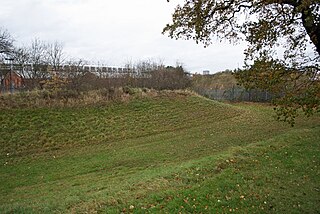
Raw Dykes is a Roman earthwork and scheduled monument in Leicester. The monument consists of two parallel banks up to 20 metres apart, with an excavated channel running between them. A stretch 110 metres long survives, but originally the earthwork was at least 550 metres in length.

Ulnaby is an abandoned village and scheduled ancient monument in the grounds of Ulnaby Hall Farm, near High Coniscliffe, County Durham, England. The toft village was occupied from the late-13th to the 16th century and temporary buildings were erected in the 19th century. Ulnaby Hall farm appears to have been built in the late-16th century, supplanting a high status medieval manorial enclosure associated with the original village. It is thought that the village shrank because of the change from labour-intensive arable farming to pasture, before being abandoned and the site was subsumed into the farm as pasture.

There are 27 scheduled monuments in Maidstone, Kent, England. In the United Kingdom, a scheduled monument is an archaeological site or historic building of "national importance" that has been given protection against unauthorised change by being placed on a list by the Secretary of State for Digital, Culture, Media and Sport; Historic England takes the leading role in identifying such sites. Scheduled monuments are defined in the Ancient Monuments and Archaeological Areas Act 1979 and the National Heritage Act 1983. They are also referred to as scheduled ancient monuments. There are about 20,000 scheduled monument entries on the list and more than one site can be included in a single entry. While a scheduled monument can also be recognised as a listed building, Historic England considers listed building status as a better way of protecting buildings than scheduled monument status. If a monument is considered by Historic England to "no longer merit scheduling" it can be removed from the schedule.

There are ten scheduled monuments in Coventry. In the United Kingdom, a scheduled monument is a "nationally important" archaeological site or historic building that has been given protection against unauthorised change by being placed on a list by the Secretary of State for Digital, Culture, Media and Sport; English Heritage takes the leading role in identifying such sites. Monuments are defined in the Ancient Monuments and Archaeological Areas Act 1979 and the National Heritage Act 1983. Scheduled monuments—sometimes referred to as scheduled ancient monuments—can also be protected through listed building procedures, and English Heritage considers listed building status to be a better way of protecting buildings and standing structures. A scheduled monument that is later determined to "no longer merit scheduling" can be descheduled.
The following is a timeline of the history of the city of Leicester, England.

Bath and North East Somerset is a unitary authority created on 1 April 1996, following the abolition of the County of Avon, which had existed since 1974. Part of the ceremonial county of Somerset, Bath and North East Somerset occupies an area of 220 square miles (570 km2), two-thirds of which is green belt. It stretches from the outskirts of Bristol, south into the Mendip Hills and east to the southern Cotswold Hills and Wiltshire border. The city of Bath is the principal settlement in the district, but BANES also covers Keynsham, Midsomer Norton, Radstock and the Chew Valley. The area has a population of 170,000, about half of whom live in Bath, making it 12 times more densely populated than the rest of the area.

There are over 670 scheduled monuments in the ceremonial county of Somerset in South West England. The county consists of a non-metropolitan county, administered by Somerset Council. The two administratively independent unitary authorities, which were established on 1 April 1996 following the breakup of the county of Avon, are North Somerset and Bath and North East Somerset. These unitary authorities include areas that were once part of Somerset before the creation of Avon in 1974.

This is a list of scheduled monuments in the English county of Lancashire.

Abbot Penny's Wall is a monastic boundary wall which once partially enclosed the grounds of Leicester Abbey. It stands in Abbey Park to the west of the City of Leicester, England. The wall was built around 1500 by John Penny, Abbot of Leicester from 1496 to 1509. It is a rare example of medieval English brickwork. Restored in the 19th, 20th and 21st centuries, the wall is now in the care of Leicester City Council and is a Grade I listed structure and a scheduled monument.
There are 208 scheduled monuments in the county of Leicestershire, England. These protected sites date in some cases from the Neolithic period and include barrows, ruined abbeys, castles, moated sites, churchyard crosses and Iron Age hill forts. In the United Kingdom, the scheduling of monuments was first initiated to ensure the preservation of "nationally important" archaeological sites or historic buildings. Protection is given to scheduled monuments under the Ancient Monuments and Archaeological Areas Act 1979.


