List
| Image | Name | Feature | Location | Notes |
|---|---|---|---|---|
 | All Saints Church and graveyard | Church | Annesley, Ashfield | Remains of medieval C13th church and graveyard. The church was abandoned when a new church for the colliery village of Annesley was built in 1874. |
 | Anglian high cross in the churchyard of St Helen's Church | Cross | Stapleford, Broxtowe | |
 | Annesley motte and bailey castle | Castle | Annesley, Ashfield | |
 | Archbishop's Palace | Building | Southwell | The palace dates from the 14th Century. Cardinal Wolsey lived here. The arrest of Charles Ӏ was formalised here, following his capture in Southwell. [4] |
| Averham moat and enclosure | Moated site | Averham, Newark | ||
| Beacon Hill camp | Settlement | Gringley on the Hill, Bassetlaw | ||
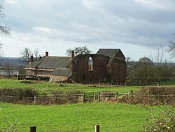 | Beauvale Priory | Building | Greasley, Broxtowe | Priory established at Beauvale in 1343 for the Carthusian Order by Sir Nicholas de Cantilupe (Lord of Ilkeston in Derbyshire and Lord of Greasley in Nottinghamshire), with Royal consent from Edward III. |
 | Beeston Lodge | Building | Clipstone, Mansfield | The 14th century site was a fortified agricultural community enclosed by Edward II as an addendum to the south-west of Clipstone Park. |
 | Bestwood Colliery engine house | Building | Bestwood St. Albans | The country's only example of a vertical duplex steam winding engine. Built in 1873 at the Worsley Mesnes Ironworks, Wigan. The pit closed in 1967. |
| Bingham medieval settlement | Settlement | Bingham | Immediately west of Carnarvon School | |
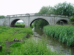 | Blyth New Bridge | Bridge | Blyth, Bassetlaw | Grade I listed bridge, built by John Carr in 1770, which carries the A634 over the River Ryton. |
 | Blyth Priory | Building | Blyth, Bassetlaw | Blyth Priory was founded in 1088 by Roger de Busli, as a house of Benedictine Monks. [5] |
| Blyth School | Building | Blyth, Bassetlaw | ||
 | Bothamsall motte and bailey castle and hollow way | Castle | Bothamsall, Bassetlaw | Overlooking the River Meden |
| Bowl barrow at Holbeck | Barrow | Holbeck, Bassetlaw | 240m SSE of Woodend Farm | |
| Bowl barrow at Laxton | Barrow | Laxton and Moorhouse, Newark | 70m South of church of St Michael | |
| Bowl barrow at Perlethorpe | Barrow | Perlethorpe cum Budby, Newark | 452m NW of Cameleon Lodge | |
| Bowl barrow at Thorpe | Barrow | Thorpe, Newark | 160m SE of Wharf Farm | |
| Castle Hill | Castle | Thurgarton, Newark | ||
| Castle Hill fortified manor | Fort | Ashfield | ||
| Caves at Drury Hill | Cave | Nottingham | ||
| Caves under Nos 3-7 Middle Pavement | Cave | Nottingham | ||
| Cellar under No 8, Castle Gate | Building | Nottingham | ||
| Civil War defences | Military | Coddington, Newark | 270m and 300m West of Vale Farm | |
| Civil War fieldwork on Crankley Point | Military | South Muskham, Newark | ||
| Civil War gun battery at Shelford | Military | Shelford and Newton, Rushcliffe | 50m SW of St Peters and St Paul's Church | |
| Civil War gun battery and covered way | Military | Wiverton Hall, Rushcliffe | Immediately SE of Wiverton Hall | |
| Civil War redoubt at Newark | Military | Newark | 550m SE of Valley Farm | |
| Civil War redoubt at Newark | Military | Newark | 680m NW of Dairy Farm | |
| Civil War redoubt at South Muskham | Military | South Muskham, Newark | 580m ENE of sugar refinery | |
| Civil War redoubt on Beacon Hill | Military | Newark | 550m NW of The Firs | |
| Civil War redoubt on Crankley Point | Military | South Muskham, Newark | ||
| Civil War sconce at Newark | Military | Newark | 650m NW of Devon Bridge | |
| Civil War Sconce at South Muskham | Military | South Muskham, Newark | 150m West of Muskham Bridge | |
| Civil War town defences within the Friary Garden | Military | Newark | ||
| Coal mining remains at Broad Oak Farm | Mining | Strelley, Broxtowe | ||
| Cockpit Hill, Ramsdale Park | Earthwork | Calverton | A circular earthwork bank of a hillfort, excavated in 1974. | |
 | Cranmer's Mound | Moated site | Aslockton, Rushcliffe | Motte castle, prospect mound, moated fishponds, enclosure, hollow way and ridge and furrow |
 | Creswell Gorge Palaeolithic and later prehistoric sites, including Pinhole Cave, Mother Grundy's Parlour and Robin Hood's Cave | Settlement | Creswell, Worksop | Creswell Crags is a limestone gorge on the border between Derbyshire and Nottinghamshire, near the villages of Creswell and Whitwell. The cliffs in the ravine contain several caves that were occupied during the last ice age, between around 43,000 and 10,000 years ago. Its caves contain the northernmost cave art in Europe. |
 | Creswell Gorge Palaeolithic and later prehistoric sites, including Boat House Cave and Church Hole Cave | Settlement | Creswell, Worksop | See above |
| Crococalana Roman town | Settlement | Collingham, Newark | Brough was the site of the Roman town of Crococalana, which grew around a military fort of the 1st century. The town spread along the Fosse Way for about a mile, and had ditched defences. [6] | |
 | Cross in St Michael's churchyard | Cross | Laxton and Moorhouse, Newark | |
 | Cuckney Castle | Castle | Cuckney, Bassetlaw | A motte and bailey fortress founded by Thomas de Cuckney. The low remains can be found at the edge of the churchyard of St Mary's Church, Norton Cuckney. |
| Dog Island moat near Gainsborough | Moated site | Beckingham, Bassetlaw | ||
| Dovecote at Barnby Hall | Building | Barnby in the Willows, Newark | 250m NW of Barnby Hall | |
| Dovecote at Flintham | Building | Flintham, Rushcliffe | 240m East of Home Farm | |
| Dovecote at Home Farm | Building | Nottingham | 600m east of Home Farm | |
| Dovecote at Manor Farm | Building | Barton in Fabis, Rushcliffe | ||
| Earlshaw Hall moat | Moated site | Caunton, Newark | ||
| Earthwork to East of Wellow | Earthwork | Wellow | ||
| Fishponds at Annesley | Ponds | Annesley, Ashfield | 170m South of Damstead Farm | |
| Fishponds at Ashfield | Ponds | Ashfield | 220m East of St Wilfrid's Church | |
| Fishponds at Broxtowe | Ponds | Broxtowe | 90m south east St Mary's Church | |
| Fishponds at Laxton | Ponds | Laxton and Moorhouse, Newark | 220m SW of St Michael's Church | |
| Fleet Plantation moated site | Moated site | Rampton, Bassetlaw | ||
| Formal and water gardens at Shireoaks Hall | Gardens | Shireoaks, Bassetlaw | ||
| Fountain Dale moat | Moated site | Lindhurst, Newark | ||
| Fox Wood earthworks | Earthwork | Calverton | Site of a hillfort with oval ditches and banks. [7] | |
| Gaddick Hill medieval motte and bailey castle and post-medieval manor house | Castle | Egmanton, Newark | ||
 | Greasley Castle | Castle | Greasley, Broxtowe | In 1340 Sir Nicholas de Cantelupe converted his manor house (alongside Greasley church) into Greasley Castle. Greasley Castle Farm now stands on the site. [8] |
| Gun platform | Military | South Muskham, Newark | 440m SE of Muskham Bridge | |
 | Haughton Chapel | Building | Haughton, Bassetlaw | Ruin of St James' church at Haughton. The earliest parts of the building are 12th-century. The roof was lost in 1915. |
| Haughton decoy and motte and bailey castle | Castle | Haughton, Bassetlaw | ||
| Hawton moated site, fishpond, Civil War redoubt and ridge and furrow | Moated site | Hawton, Newark | ||
| Hayton Castle moated site and fishpond | Moated site | Hayton, Bassetlaw | ||
| Henge at Bingham | Henge | Bingham, Rushcliffe | 850m SE of Foss Road Farm | |
| Henge at Gunthorpe | Henge | Gunthorpe, Newark | 120m South of Lodge Farm | |
| Iron Age settlement | Settlement | South Muskham, Newark | ||
| Jordan Castle | Castle | Wellow, Newark | Ringwork, fortified manor, hollow way, fishpond and ridge and furrow | |
| Kilvington medieval settlement and part of an open field system | Settlement | Kilvington, Newark | 400m SW of Staunton Hall | |
 | King John's Palace | Building | King's Clipstone, Mansfield | Remains of a former medieval royal residence in Clipstone. It has been known as "King John's Palace" (although King John only spent a few days here) since the 18th century. It was previously known as the "King's Houses", built for Henry II from 1176 within a deer park. |
 | King's Mill Viaduct | Bridge | Mansfield | Five arch viaduct built by Josiah Jessop to carry the Mansfield & Pinxton Railway, a horse-drawn railway constructed in 1819 to transport stone and lime from Mansfield to the head of the Pinxton branch of the Cromford Canal. The structure remained in use as part of a siding until 1970. The viaduct now carries a footpath. [9] |
| Langford medieval village | Settlement | Langford, Newark | Includes moat and open field system 450m NW of Elmtree Farm | |
 | Lenton Priory | Church | Nottingham | |
| Little Carlton medieval village and part of the meadow field system | Settlement | South Muskham, Newark | Earthworks and buried remains of Little Carlton medieval village, referred to as Carleton in the Domesday Book of 1086. | |
| Manor Farm moat | Moated site | Scrooby, Bassetlaw | ||
 | Margidunum Roman Station | Settlement | Bingham, Rushcliffe | The Roman camp of Margidunum is situated on the Fosse Way, halfway between Leicester and Lincoln. [10] |
 | Market cross at Gringley | Cross | Gringley on the Hill, Bassetlaw | Stone cross at the junction of Cross Hill and High Street. A plaque on the steps of the cross states that a market charter was granted to the village on 2 November 1252. |
 | Market cross, Kirkby in Ashfield | Cross | Ashfield | |
| Markham Moor Bridge (or 'Mirihil' Bridge) | Bridge | West Drayton, Bassetlaw | ||
 | Mattersey Priory Gilbertine monastery | Building | Mattersey, Bassetlaw | The priory was founded by Roger FitzRalph in 1185, and was dedicated to St Helen. It was constructed on a gravel island in the River Idle. |
| Medieval city wall | Defences | Nottingham | ||
| Medieval market cross and 19th century commemorative cross | Cross | Colston Bassett, Rushcliffe | ||
| Medieval settlement and open field system | Settlement | West Burton, Bassetlaw | Immediately SE of Low Farm | |
| Medieval settlement and remains of open fields | Settlement | East Stoke, Newark | Immediately west of East Stoke village | |
| Medieval settlement including a moated site and open field system | Settlement | West Markham, Bassetlaw | Immediately NE and South of Hall Farm | |
| Medieval village | Settlement | Sibthorpe, Rushcliffe | Including monastic college, chapel, moat, fishponds, dovecote and open field system 200m South of Manor Farm | |
| Minor Romano-British villa | Building | Car Colston, Rushcliffe | Moat and associated medieval manorial and village earthworks, including six fishponds | |
| Moat and fishpond at Strelley | Moated site | Strelley, Broxtowe | 240m SE of All Saints' Church | |
| Moat, fishpond, enclosures, hollow way and postmill mound | Moated site | Kinoulton, Rushcliffe | 600m NW of Barland Fields | |
| Moat, three fishponds, enclosures, hollow way and part of a road at Hall Yard | Moated site | Weston, Newark | ||
| Moat, two fishponds, boundary bank and ditch and two leats | Moated site | Whatton-in-the-Vale, Rushcliffe | ||
| Moat, two fishponds, fishstews and pond bay | Moated site | Coddington, Newark | West of Balderton Lane | |
| Moated fishpond complex | Moated site | Egmanton, Newark | With moat, fishstews, seven fishponds with sluices, ridge and furrow and a leat | |
| Moated site | Moated site | Newark | 750m NW of Dairy Farm | |
| Moated site and fishpond east of Misson village | Moated site | Misson, Bassetlaw | ||
| Moated site and fishponds | Moated site | Rushcliffe | 225m North of Wiverton Hall | |
| Moated site west of Church Road | Moated site | Harby, Newark | ||
| Moated site, fishponds and decoy pond | Moated site | Winkburn, Newark | 490m NW of Park Spring Farm | |
| Motte and bailey castle adjacent to River Trent | Castle | East Bridgford, Rushcliffe | ||
| Motte and bailey castle and associated medieval and post-medieval manorial remains, including six fishponds | Castle | Laxton and Moorhouse, Newark | ||
| Mound at Oxton | Earthwork | Oxton | 270m West of Moorfields Farm | |
| Mound at Syke Breck Farm | Earthwork | Blidworth | ||
| Mound, East of Haywood Oaks Farm | Earthwork | Blidworth | ||
| Mound on Hamilton Hill | Earthwork | Ashfield | ||
| Mound, South of Sand Lane | Earthwork | Besthorpe, Newark | ||
 | Newark Castle | Castle | Newark | Castle was founded in Newark-on-Trent in the mid-12th century by Alexander, Bishop of Lincoln. Originally a timber castle, it was rebuilt in stone towards the end of the century. Dismantled in the 17th century after the English Civil War, the castle was restored in the 19th century. |
| Newark town wall (Lombard Street) | Defences | Newark | ||
| Newbold medieval settlement and part of the open field system | Settlement | Kinoulton, Rushcliffe | 330m NE of Manor Farm | |
| Norwell Woodhouse moat and fishpond | Moated site | Norwell, Newark | ||
 | Nottingham Castle | Castle | Nottingham | Medieval motte and bailey castle built in 1068. In 1651 all of the fortifications were demolished except for the gatehouse and the base of Edward IV's tower. [11] |
| Old Hall moat and two fishponds | Moated site | Norwell, Newark | ||
 | Old Trent Bridge | Bridge | Rushcliffe, Nottingham | Replaced by the current Trent Bridge in 1871. |
| Oldox camp | Settlement | Oxton | Hill-fort that is roughly triangular and encloses 1.5 acres. Roman coins in a pot and a Saxon burial have been found here. [12] | |
 | Papplewick Pumping Station | Building | Papplewick | Near the village of Papplewick, built by Nottingham Corporation Water Department between 1881 and 1884 to pump water from the Bunter sandstone to provide drinking water to the City of Nottingham. |
 | Queen's Sconce | Military | Devon Park, Newark | Civil War sconce built by the Royalist army as part of the defences around Newark-on-Trent. The earthwork is larger than 100m x 100m with 9m high ramparts. |
| Rectangular barrows at North Muskham | Barrow | North Muskham, Newark | ||
| Ringwork at Kingshaugh Farm | Earthwork | East Markham, Bassetlaw | ||
| Rock cut houses N of Castle Boulevard | Building | Nottingham | ||
| Rock cut houses S of Nottingham Castle | Building | Nottingham | ||
| Rolleston Manor | Moated site | Rolleston, Newark | Three moats, eight fishponds with sluices, ridge and furrow and a leat | |
 | 2 Roman camps at Calverton | Settlement | Calverton | Flat present fields (to the West of Dover Beck, which feeds the River Trent) have no standing remains. Buried structures are clearly visible though on aerial photographs. The site is about 300m x 300m. At the junction of Whinbush Lane and B6386, 350m NE of Lodge Farm Hoards of Roman coins have also been found in Calverton as recently as 1960. [13] |
 | Roman camp at Farnsfield | Settlement | Farnsfield | No standing remains in the present fields but excavations in 1978 revealed Roman defensive ditches and remains. Outlines of the camp structure are clearly visible on aerial photos, [14] including the satellite view on Google Maps. [15] The camp was about 200m x 200m. By Longland Lane, 470m South of Carr Banks Farm |
| Roman camp at Holme | Settlement | Holme, Newark | 750m East of Church Cottages | |
| Roman fort and a section of Roman road | Fort | Scaftworth, Bassetlaw | 350m NW of Holly House Farm | |
| Roman site on Red Hill | Settlement | Thrumpton, Rushcliffe | ||
| Roman vexillation fortress | Fort | Edingley, Southwell | 310m and 530m South of Osmanthorpe Manor | |
| Roman villa at Oldcoates | Building | Styrrup with Oldcotes, Bassetlaw | ||
| Roman villa complex and Anglo-Saxon cemetery | Building | Southwell | ||
| Roman villa at Mansfield | Building | Mansfield | ESE of Northfield House | |
| Romano-British nucleated enclosed settlement and Roman villa complex at Glebe Farm | Settlement | Barton in Fabis, Rushcliffe | ||
| Round Hill at Lambley | Lambley, Gedling | |||
 | Rufford Abbey Cistercian monastery | Building | Rufford | Monastic precinct, water-management works, pre-monastic open-field system and post-medieval building |
| Saxon cemetery | Cemetery | Upper Broughton, Rushcliffe | SW of Broughton Lodge | |
| Segelocum Roman town | Settlement | Sturton Le Steeple, Bassetlaw | ||
| Settlement at Cromwell | Settlement | Cromwell, Newark | 1200m West of Cromwell Village | |
| Settlement site at Morton | Settlement | Fiskerton cum Morton, Newark | ||
| Site at Cromwell | Cromwell, Newark NNE of village | Discovered by aerial photography | ||
| Site of Abbey Church | Newstead | |||
| Site of Ad Pontem, Stoke by Newark | Thorpe, Newark | |||
| Site of Old Hall, South of Haughton Hall Farm | Haughton, Bassetlaw | |||
| Site of pit alignments | South Muskham, Newark | |||
| Skegby Manor House | Building | Ashfield | Remains of a medieval hall and earthwork from the early C13th. Immediately SE of Pond Cottage | |
 | Slight univallate (single-walled) hillfort | Fort | Farnsfield | Visible remains of Iron Age Hillfort are an earthwork bank surrounded by a ditch. Buried remains, pottery fragments, Roman tiles and a Bronze Age axe have been found here. 170m West of Combs Farm |
 | St Helen's Church | Church | South Wheatley, Bassetlaw | |
| St John Baptist's Church and graveyard | Church | Colwick, Nottingham | ||
 | St Mary's Church | Church | Colston Bassett, Rushcliffe | |
 | St Wilfrid's Church and churchyard | Church | Kinoulton, Rushcliffe | Abandoned at the end of the eighteenth century, when the church was moved closer to the village |
 | Standing cross at Collingham | Cross | Collingham, Newark | On the West side of High Street |
| Standing cross at Holme | Cross | Holme, Newark | 140m North of The Old Hall | |
| Standing cross at North Muskham | Cross | North Muskham, Newark | 300m North of Trent Farm | |
 | Standing cross known as Beaumond Cross | Cross | Newark | Relocated to London Road Gardens from the south end of Carter Gate, a much weathered 15th century cross shaft repaired and ornamented in 1778, restored again in 1801. |
 | Standing cross known as Bottom Cross | Cross | Linby | |
 | Standing cross known as Top Cross | Cross | Linby | |
 | Standing cross on Church Street, Mansfield Woodhouse | Cross | Mansfield | |
 | Standing cross on Upper Broughton village green | Cross | Upper Broughton, Rushcliffe | |
| Standing cross on Walkeringham village green | Cross | Walkeringham, Bassetlaw | ||
| Succession of rectilinear enclosures SW of Shelford Manor | Enclosure | Shelford and Newton, Rushcliffe | ||
| Thorpe in the Glebe medieval settlement | Settlement | Thorpe in the Glebe, Rushcliffe | Including church site and open field system | |
| Three round barrows on Laxton Common | Barrow | Laxton and Moorhouse, Newark | ||
| Timber circle | Henge | East Stoke, Newark | 430m NE of Stoke Fields Farm | |
| Two moats and five fishponds at Top Green | Moated site | Sibthorpe, Rushcliffe | ||
| Wansley Hall manorial site | Building | Bagthorpe, Ashfield | Remains of medieval Hall which was built c.1200AD. | |
| West Bridge | Bridge | Clumber Park | ||
 | Whimpton Moor medieval village and moated site | Settlement | Ragnall, Bassetlaw | |
| Wigthorpe medieval settlement and part of the open field system | Settlement | Carlton in Lindrick, Bassetlaw | Immediately North of Wigthorpe Farm | |
| Willoughby deserted medieval village | Settlement | Norwell, Newark | Post-medieval moated manor, church, six fishponds, ridge and furrow and hollow way | |
| Worksop Castle | Castle | Bassetlaw | Eleventh century motte castle and twelfth century shell keep castle |