Brough, although colloquially pronounced ‘Broom’ by the locals and sometimes known as Brough under Stainmore, is a village and civil parish in the historic county of Westmorland and the ceremonial county of Cumbria, England, within the Westmorland and Furness unitary authority area, on the western fringe of the Pennines near Stainmore. The village is on the A66 trans-Pennine road, and the Swindale Beck, and is about 8 miles (13 km) south east of Appleby-in-Westmorland. Brough is situated 5 miles (8.0 km) north east of Kirkby Stephen and 28 miles (45 km) north east of Kendal on the A685.

There are 37 scheduled monuments in Greater Manchester, a metropolitan county in North West England. In the United Kingdom, a scheduled monument is a "nationally important" archaeological site or historic building that has been given protection against unauthorised change by being placed on a list by the Secretary of State for Digital Culture, Media and Sport; Historic England recommends sites for scheduling to the Secretary of State. Scheduled monuments are defined in the Ancient Monuments and Archaeological Areas Act 1979 and the National Heritage Act 1983. There are nearly 20,000 entries on the schedule, which is maintained by Historic England as part of the National Heritage List for England; more than one site can be included in a single entry. While a scheduled monument can also be recognised as a listed building, Historic England's aim is to set the most appropriate form of protection in place for the building or site. Applications to deschedule a site are administered Historic England, who will carry out an assessment and make a recommendation to the Secretary of State.

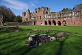
Verterae was a Roman fort in the modern-day village of Brough, Cumbria, England. Occupied between the 1st and 5th centuries AD, it protected a key Roman road in the north of England. In the 11th century, Brough Castle was built on part of the site by the Normans. Archaeologists explored the remains during the 20th century, and it is now protected under UK law.

There are over 670 scheduled monuments in the ceremonial county of Somerset in South West England. The county consists of a non-metropolitan county, administered by Somerset County Council, which is divided into five districts, and two unitary authorities. The districts of Somerset are West Somerset, South Somerset, Taunton Deane, Mendip and Sedgemoor. The two administratively independent unitary authorities, which were established on 1 April 1996 following the breakup of the county of Avon, are North Somerset and Bath and North East Somerset. These unitary authorities include areas that were once part of Somerset before the creation of Avon in 1974.
This is a list of scheduled monuments in the English county of Lancashire.

This is a list of scheduled monuments in the Borough of Erewash in the English county of Derbyshire.
This is a list of scheduled monuments in the district of Amber Valley in the English county of Derbyshire.
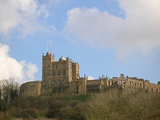
This is a list of scheduled monuments in the district of Bolsover in the English county of Derbyshire.
This is a list of scheduled monuments in the district of High Peak in the English county of Derbyshire.
This is a list of scheduled monuments in the district of North East Derbyshire in the English county of Derbyshire.

This is a list of scheduled monuments in the City of Derby unitary authority in the English county of Derbyshire.
There are more than 1000 scheduled monuments in the county of Dorset, in South West England. These protected sites date from the Neolithic period and include barrows, stone circles, hill figures, ancient Roman sites, castle ruins, and medieval abbeys. In the United Kingdom, the scheduling of monuments was first initiated to ensure the preservation of "nationally important" archaeological sites or historic buildings. Protection is given to scheduled monuments under the Ancient Monuments and Archaeological Areas Act 1979.
There are 563 scheduled monuments in the county of Gloucestershire, England. These protected sites date from the Neolithic period in some cases and include barrows, moated sites, ruined abbeys, castles, Roman villas and tithe barns. In the United Kingdom, the scheduling of monuments was first initiated to ensure the preservation of "nationally important" archaeological sites or historic buildings. Protection is given to scheduled monuments under the Ancient Monuments and Archaeological Areas Act 1979.
There are 735 scheduled monuments in the county of Hampshire, England. These protected sites date from the Neolithic period and include barrows, artillery forts, ruined abbeys, castles, and Iron Age hill forts. In the United Kingdom, the scheduling of monuments was first initiated to ensure the preservation of "nationally important" archaeological sites or historic buildings. Protection is given to scheduled monuments under the Ancient Monuments and Archaeological Areas Act 1979.
There are 221 scheduled monuments in the county of Northamptonshire, England. These protected sites date in some cases from the Neolithic period and include barrows, artillery forts, ruined abbeys, castles, and Iron Age hill forts. In the United Kingdom, the scheduling of monuments was first initiated to ensure the preservation of "nationally important" archaeological sites or historic buildings. Protection is given to scheduled monuments under the Ancient Monuments and Archaeological Areas Act 1979.
There are 689 scheduled monuments in the county of Kent, England. These protected sites date in some cases from the Neolithic period, and include barrows, artillery forts, ruined abbeys, castles, and Iron Age hill forts. In the United Kingdom, the scheduling of monuments was first initiated to ensure the preservation of "nationally important" archaeological sites and historic buildings. Protection is given to scheduled monuments under the Ancient Monuments and Archaeological Areas Act 1979.
There are 379 scheduled monuments in the county of Oxfordshire, England. These protected sites date in some cases from the Neolithic period, and include stone circles, a medieval tithe barn, ruined abbeys, castles, and Roman villas. In the United Kingdom, the scheduling of monuments was first initiated to ensure the preservation of "nationally important" archaeological sites and historic buildings. Protection is given to scheduled monuments under the Ancient Monuments and Archaeological Areas Act 1979.