
The Quantock Hills west of Bridgwater in Somerset, England, consist of heathland, oak woodlands, ancient parklands and agricultural land. They were England's first Area of Outstanding Natural Beauty, designated in 1956.
Little Solsbury Hill is a small flat-topped hill and the site of an Iron Age hill fort, above the village of Batheaston in Somerset, England. The hill rises to 625 feet (191 m) above the River Avon, which is just over 1 mile (2 km) to the south, and gives views of the city of Bath and the surrounding area. It is within the Cotswolds Area of Outstanding Natural Beauty.

Small Down Knoll, or Small Down Camp, is a Bronze Age hill fort near Evercreech in Somerset, England. The hill is on the southern edge of the Mendip Hills, and rises to 222 m (728 ft).

Dolebury Warren is a 90.6 hectares biological Site of Special Scientific Interest (SSSI) and ancient monument near the villages of Churchill and Rowberrow in North Somerset, part of South West England. It is owned by the National Trust, who acquired the freehold in 1983, and managed by the Avon Wildlife Trust.

Trendle Ring is a late prehistoric earthwork on the Quantock Hills near Bicknoller in Somerset, England. It is a Scheduled Monument. In 2013 it was added to the Heritage at Risk Register due to vulnerability to plant growth.

Plainsfield Camp is a possible Iron Age earthwork on the Quantock Hills near Aisholt in Somerset, England.
Dowsborough Camp is an Iron Age hill fort on the Quantock Hills near Nether Stowey in Somerset, England. It has been designated as a Scheduled Monument. The fort and associated round barrow has been added to the Heritage at Risk Register due to vulnerability to vehicle damage and erosion.
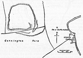
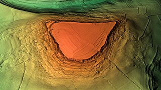
Cannington Camp is a Bronze Age and Iron Age hill fort near Cannington, Somerset, England. It is a Scheduled Ancient Monument.

Cleeve Toot is an Iron Age univallate hillfort above Goblin Combe, Cleeve, Somerset, England. It is a Scheduled Ancient Monument.
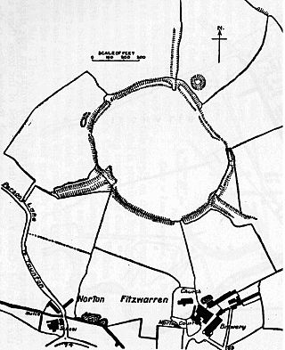
Norton Camp is a Bronze Age hill fort at Norton Fitzwarren near Taunton in Somerset, England.
Blacker's Hill is an Iron Age hill fort at Chilcompton, 4.5 kilometres (3 mi) south west of Radstock, Somerset, England. It has been designated as a Scheduled Ancient Monument.

Cow Castle is an Iron Age hillfort 5.75 kilometres (4 mi) West South West of Exford, Somerset, England within the Exmoor National Park. It is a Scheduled Monument. It has been added to the heritage at Risk register because of the risk from bracken.

Kenwalch's Castle is probably an Iron Age hill fort that may have been converted into a Roman fortress, near Penselwood, Somerset, England, 6.6 kilometres (4 mi) east south east of Bruton at grid reference ST747335. It is a Scheduled Ancient Monument. It is believed to be named after Cenwalh of Wessex.
Curdon Camp is a univallate Iron Age hill fort in the West Somerset district of Somerset, England. It is a Scheduled Ancient Monument.
Westbury Camp is a univallate Iron Age hill fort in the Mendip Hills in Somerset, England. The hill fort is situated in the parish of Rodney Stoke, approximately 1 mile (1.6 km) north-east of the village of Draycott and 1.5 miles (2.4 km) north-west of Westbury-sub-Mendip. The camp is largely situated in a hill slope. The north east defences have largely been destroyed by small quarries over the years. The narrow top of the hill bank suggests that it may have been surmounted by a dry stone wall. Along part of the east side of the camp there are traces of a berm between the bank and the outer ditch and at the western angle shallow quarry pits occur internally and externally set back from the 'rampart'.

Mounsey Castle is an Iron Age irregular triangular earthwork of 1.75 hectares north west of Dulverton, Somerset, England. It has been scheduled as an ancient monument. It has been added to the Heritage at Risk Register.
Broomfield Camp is a univallate Iron Age hill fort in the Taunton Deane district of Somerset, England. The hill fort is situated approximately 0.6 miles (0.97 km) south-east from the village of Broomfield. Broomfield Camp dates from late prehistoric or Roman times. The camp was searched in 1968 and the result uncovered a trench through a bank and ditch which produced Iron Age pottery.

Cadson Bury is an Iron Age hillfort about 2 miles (3.2 km) south-west of Callington, in Cornwall, England.

