Shapwick Heath

Last updated

Shapwick Heath
Site of Special Scientific Interest
Shapwickheath.jpg
Somerset UK location map.svg
Red pog.svg
Location within Somerset
Location Somerset
Grid reference ST430403
Coordinates 51°09′33″N2°48′52″W / 51.1591°N 2.8144°W / 51.1591; -2.8144 Coordinates: 51°09′33″N2°48′52″W / 51.1591°N 2.8144°W / 51.1591; -2.8144
InterestBiological
Area394 hectares (3.94 km2; 1.52 sq mi)
Notification 1967 (1967)
Natural England website

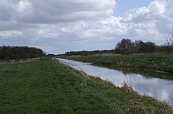
Shapwick Heath is a 394.0-hectare (973.6 acre) biological Site of Special Scientific Interest and national nature reserve [1] between Shapwick and Westhay in Somerset, notified in 1967. It is part of the Brue Valley Living Landscape conservation project. The project commenced in January 2009 and aims to restore, recreate and reconnect habitat. It aims to ensure that wildlife is enhanced and capable of sustaining itself in the face of climate change [2] while guaranteeing farmers and other landowners can continue to use their land profitably. It is one of an increasing number of landscape scale conservation projects in the UK. [3] [4] [5]

Shapwick Heath, part of the Avalon Marshes in the Somerset Levels Wetlands, and managed as a national nature reserve by Natural England, is a former raised bog lying in the basin of the River Brue. The site supports a diverse community of terrestrial and aquatic invertebrates. National rarities are the Greater Silver Diving Beetle (Hydrophilus piceus) and the Lesser Silver Diving Beetle (Hydrochara caraboides) which is now confined nationally to the Brue Basin Peat Moors. [6]

The Sweet Track, an ancient causeway crosses the site. It is one of the oldest engineered roads known and the oldest timber trackway discovered in Northern Europe.

The adjoining Shapwick Moor has been purchased by the Hawk and Owl Trust as a reserve. Ham Wall nature reserve is to the east.

Related Research Articles

Redgrave and Lopham Fens

Redgrave and Lopham Fens is a 127 hectare biological Site of Special Scientific Interest between Thelnetham in Suffolk and Diss in Norfolk. It is a national nature reserve, a Ramsar internationally important wetland site, a Nature Conservation Review site, Grade I, and part of the Waveney and Little Ouse Valley Fens Special Area of Conservation. It is managed by the Suffolk Wildlife Trust.

Somerset Levels Coastal plain and wetland area of Somerset, England

The Somerset Levels are a coastal plain and wetland area of Somerset, England, running south from the Mendips to the Blackdown Hills.

River Huntspill River in Somerset, England

The River Huntspill is an artificial river, in the Somerset Levels, in the Sedgemoor district of Somerset, England. It was built in 1940 to supply process water to ROF Bridgwater, and has resulted in reduced flooding of the lower Brue Valley. Huntspill Sluice at the river's western end, also known as West Huntspill Sluice, separates it from the River Parrett.

Sweet Track Ancient causeway in the Somerset Levels, England

The Sweet Track is an ancient trackway, or causeway, in the Somerset Levels, England, named after its finder, Ray Sweet. It was built in 3807 BC and is the second-oldest timber trackway discovered in the British Isles, dating to the Neolithic. It is now known that the Sweet Track was predominantly built along the course of an earlier structure, the Post Track.

Shapwick, Somerset Human settlement in England

Shapwick is a village on the Polden Hills overlooking the Somerset Moors, in the Sedgemoor district of Somerset, England. It is situated to the west of Glastonbury.

Great Fen Habitat restoration project in the United Kingdom

The Great Fen is a habitat restoration project being undertaken on The Fens in the county of Cambridgeshire in the United Kingdom. It is one of the largest restoration projects in the country, and aims to create a 3,700 hectare wetland and aims to connect Woodwalton Fen National Nature Reserve (NNR), Holme Fen NNR and other nature reserves to create a larger site with conservation benefits for wildlife and socio-economic benefits for people.

Edington, Somerset Human settlement in England

Edington is a rural village, situated on the north side of the Polden Hills in the Sedgemoor district of Somerset, England.

River Brue River in Somerset, England

The River Brue originates in the parish of Brewham in Somerset, England, and reaches the sea some 50 kilometres (31 mi) west at Burnham-on-Sea. It originally took a different route from Glastonbury to the sea, but this was changed by Glastonbury Abbey in the twelfth century. The river provides an important drainage route for water from a low-lying area which is prone to flooding which man has tried to manage through rhynes, canals, artificial rivers and sluices for centuries.

Catcott, Edington and Chilton Moors

Catcott, Edington and Chilton Moors SSSI is a 1083 hectare biological Site of Special Scientific Interest in Somerset, England notified in 1967. It is close to the villages of Edington and Catcott.

Westhay Moor Site of Special Scientific Interest

Westhay Moor is a 513.7-hectare (1,269-acre) biological Site of Special Scientific Interest 2.5 kilometres (1.6 mi) north-east of Westhay village and 4 kilometres (2.5 mi) from Wedmore in Somerset, England, notified in 1971. Westhay Moor is also notified as part of the Somerset Levels and Moors Special Protection Area under the EU Birds Directive and as a Ramsar site, and a National Nature Reserve.

Sharpham Human settlement in England

Sharpham is a village and civil parish on the Somerset Levels near Street and Glastonbury in the Mendip district of Somerset, England. It is located near the River Brue.

Colony Bog and Bagshot Heath Site of Special Scientific Interest in Surrey, England

Colony Bog and Bagshot Heath is a 1,130.5-hectare (2,794-acre) biological Site of Special Scientific Interest between Camberley and Woking in Surrey, England. Part of it is a Nature Conservation Review site, Grade I. It is part of the Thames Basin Heaths Special Protection Area and the Thursley, Ash, Pirbright and Chobham Special Area of Conservation. It includes Brentmoor Heath, a Local Nature Reserve which is managed by the Surrey Wildlife Trust

Westhay Village in England

Westhay is a village in Somerset, England. It is situated in the parish of Meare, 4 miles (6.4 km) north west of Glastonbury on the Somerset Levels, in the Mendip district.

Shapwick Moor

Shapwick Moor is an area of 138 acres (0.56 km2) of farmland on the Somerset levels bordering Shapwick Heath and Cattcot Heath.

Catcott Human settlement in England

Catcott is a rural village and civil parish, situated close to Edington 7 miles (11.3 km) to the east of Bridgwater on the Somerset Levels to the north of the Polden Hills in the Sedgemoor district of Somerset, England.

Ham Wall Wetland nature reserve in Somerset, England

Ham Wall is an English wetland National Nature Reserve (NNR) 4 kilometres (2.5 mi) west of Glastonbury on the Somerset Levels. It is managed by the Royal Society for the Protection of Birds (RSPB). Since the last Ice Age, decomposing plants in the marshes of the Brue valley in Somerset have accumulated as deep layers of peat that were commercially exploited on a large scale in the twentieth century. Consumer demand eventually declined, and in 1994 the landowners, Fisons, gave their old workings to what is now Natural England, who passed the management of the 260 hectares Ham Wall section to the RSPB.

Red Moor (nature reserve)

Red Moor is a nature reserve and Site of Special Scientific Interest (SSSI), noted for its biological characteristics, near Lanlivery in mid Cornwall, England, UK.

Peat extraction on the Somerset Levels

Peat extraction on the Somerset Levels, in South West England has occurred since the area was first drained by the Romans, and continues today on an area of less than 0.5% of the total geography. The modern system in recycling land back to farm use and conservation has resulted in the creation of numerous Sites of Special Scientific Interest.

The Avalon Marshes Partnership is a group of conservation organisations working together in the Somerset Levels. The members are Natural England,, the Royal Society for the Protection of Birds (RSPB), the Somerset Wildlife Trust the Hawk and Owl Trust, Historic England, South West Heritage Trust and the Environment Agency. Between 2012 and 2016 the scheme was supported by a Heritage Lottery Fund grant of £1,772,500 with additional investment of £920,080 from other sources. The Avalon Marshes Centre, run by Natural England, is near the Ham Wall reserve. The network of reserves and private land managed for conservation in the Avalon marshes means that wetland management can be carried out on a landscape scale.

References

  1. "Shapwick Heath NNR". Natural England. Retrieved 10 December 2015.
  2. Brue Valley Living Landscape
  3. A Living Landscape - The Wildlife Trusts
  4. RSPB landscape conservation
  5. Natural England Future Landscapes Archived 2009-10-03 at the Wayback Machine
  6. "SSSI notification" (PDF). Natural England. Retrieved 10 December 2015.

Commons-logo.svg Media related to Shapwick Heath at Wikimedia Commons