
A Site of Special Scientific Interest (SSSI) in Great Britain or an Area of Special Scientific Interest (ASSI) in the Isle of Man and Northern Ireland is a conservation designation denoting a protected area in the United Kingdom and Isle of Man. SSSI/ASSIs are the basic building block of site-based nature conservation legislation and most other legal nature/geological conservation designations in the United Kingdom are based upon them, including national nature reserves, Ramsar sites, Special Protection Areas, and Special Areas of Conservation. The acronym "SSSI" is often pronounced "triple-S I".

Exmoor is loosely defined as an area of hilly open moorland in west Somerset and north Devon in South West England. It is named after the River Exe, the source of which is situated in the centre of the area, two miles north-west of Simonsbath. Exmoor is more precisely defined as the area of the former ancient royal hunting forest, also called Exmoor, which was officially surveyed 1815–1818 as 18,810 acres (7,610 ha) in extent. The moor has given its name to a National Park, which includes the Brendon Hills, the East Lyn Valley, the Vale of Porlock and 55 km (34 mi) of the Bristol Channel coast. The total area of the Exmoor National Park is 692.8 km2 (267.5 sq mi), of which 71% is in Somerset and 29% in Devon.

The River Fal flows through Cornwall, England, rising at Pentevale on Goss Moor and reaching the English Channel at Falmouth. On or near the banks of the Fal are the castles of Pendennis and St Mawes as well as Trelissick Garden. The River Fal separates the Roseland peninsula from the rest of Cornwall. Like most of its kind on the south coast of Cornwall and Devon, the Fal estuary is a classic ria, or drowned river valley. The Fal estuary from Tregony to the Truro River was originally called Hafaraell.

Dunkery Beacon at the summit of Dunkery Hill is the highest point on Exmoor and in Somerset, England. It is also the highest point in southern England outside of Dartmoor.

Long Dole Wood and Meadows SSSI is a 9.8 hectares biological Site of Special Scientific Interest (SSSI) between the villages of Farrington Gurney and Hinton Blewitt in Bath and North East Somerset, notified in 1987.

Barle Valley is a 1,540 acres (620 ha) Site of Special Scientific Interest within Exmoor National Park, situated in the counties of Devon and Somerset through which the River Barle flows. It was notified in its current form under the Wildlife and Countryside Act in 1988. The site includes the Somerset Wildlife Trust's Mounsey Wood Nature Reserve and the Knaplock and North Barton SSSI which has been notified since 1954.

South Exmoor is a 3132.7 hectare biological Site of Special Scientific Interest in Devon and Somerset, England, notified in 1992.
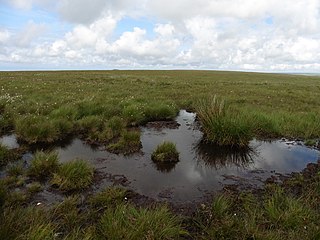
The Chains is the name given to the north-west plateau of Exmoor, Somerset, England. This plateau lies above the 1,500 feet (457 m) contour line, and includes the source of the River Barle.

Castor Hanglands is an 89.8 hectare biological Site of Special Scientific Interest west of Peterborough in Cambridgeshire. The site is also a National Nature Reserve, and it is a Nature Conservation Review site, Grade I for its woodlands and Grade 2 for its grassland. It is common land managed by Natural England.

Kings and Bakers Woods and Heaths is a 212.8 hectare Site of Special Scientific Interest (SSSI) between Heath and Reach in Bedfordshire and Great Brickhill in Buckinghamshire. The site is mainly in Bedfordshire but includes Rammamere Heath in Buckinghamshire. It was notified in 1984 under Section 28 of the Wildlife and Countryside Act 1981, and the local planning authorities are Central Bedfordshire Council and Aylesbury Vale Council. Part of it is a National Nature Reserve, and part of it is a nature reserve managed by the Wildlife Trust for Bedfordshire, Cambridgeshire and Northamptonshire. it is also a Nature Conservation Review site.
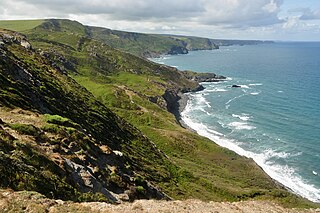
Boscastle to Widemouth is a coastal Site of Special Scientific Interest (SSSI) in Cornwall, England, noted for its biological and geological characteristics. The Dizzard dwarf oak woodland is unique and of international importance for its lichen communities, with 131 species recorded.

Upper Wye Gorge is a Site of Special Scientific Interest (SSSI), noted for its biological and geological characteristics, around Symonds Yat in the Upper Wye Valley on the Wales–England border. The site is listed in the 'Forest of Dean Local Plan Review' as a Key Wildlife Site (KWS).
Nagshead is a 120.12-hectare (296.8-acre) biological Site of Special Scientific Interest and is located near Parkend, in the Forest of Dean, Gloucestershire, and was notified in 1972. It lies within the Forest of Dean Forest Park and is part held as a reserve by the Royal Society for the Protection of Birds (RSPB). The SSSI is a relatively small area of the much larger nature reserve of RSPB Nagshead, which is a 1,250 acres (510 ha) site owned and managed by the RSPB and the Forestry Commission. The SSSI lies to the east of the Nagshead Plantation and consists of two units of assessment by Natural England.

Leckhampton Hill and Charlton Kings Common is a 63.8-hectare (158-acre) biological and geological Site of Special Scientific Interest in Gloucestershire, notified in 1954. There are five units of assessment.

