Tealham and Tadham Moors

Last updated
Tealham and Tadham Moors
Site of Special Scientific Interest
Tealhammoor.jpg
Somerset UK location map.svg
Red pog.svg
Location within Somerset
Area of Search Somerset
Grid reference ST420450
Coordinates 51°12′05″N2°49′54″W / 51.20125°N 2.83153°W / 51.20125; -2.83153 Coordinates: 51°12′05″N2°49′54″W / 51.20125°N 2.83153°W / 51.20125; -2.83153
Interest Biological
Area 917.6 hectares (9.176 km2; 3.543 sq mi)
Notification 1985 (1985)
Natural England website

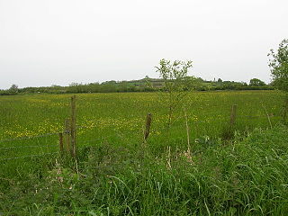
Tealham and Tadham Moors (grid reference ST420450 ) is a 917.6 hectare (2267.3 acre) biological Site of Special Scientific Interest south of Wedmore in Somerset, notified in 1985.

Ordnance Survey National Grid System of geographic grid references used in Great Britain

The Ordnance Survey National Grid reference system is a system of geographic grid references used in Great Britain, distinct from latitude and longitude. It is often called British National Grid (BNG).

Hectare metric unit of area

The hectare is an SI accepted metric system unit of area equal to a square with 100-metre sides, or 10,000 m2, and is primarily used in the measurement of land. There are 100 hectares in one square kilometre. An acre is about 0.405 hectare and one hectare contains about 2.47 acres.

Wedmore village in the United Kingdom

Wedmore is a village and civil parish in the county of Somerset, England. It is situated on raised ground, in the Somerset Levels between the River Axe and River Brue, often called the Isle of Wedmore. It forms part of Sedgemoor district. The parish consists of three main villages: Wedmore, Blackford and Theale, with the 17 hamlets of Bagley, Blakeway, Clewer, Crickham, Cocklake, Heath House, Latcham, Little Ireland, Middle Stoughton, Mudgley, Panborough, Sand, Stoughton Cross, Washbrook, West End, West Ham and West Stoughton. The parish of Wedmore has a population of 3,318 according to the 2011 census.

Land south of this site is included in Catcott, Edington and Chilton Moors SSSI.

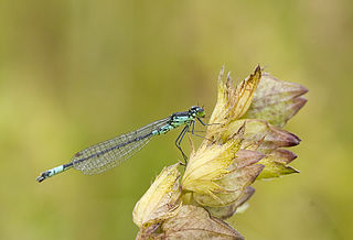
Tealham and Tadham Moors form part of the extensive grazing marsh and ditch systems of the Somerset Levels and Moors. The water table is high throughout the greater part of the year with winter flooding occurring annually, by over-topping of the River Brue. 113 aquatic and bankside vascular plant species have been recorded from the field ditches, rhynes and deep arterial watercourses. A diverse invertebrate fauna is associated in particular with ditches that have a good submerged plant community. The water beetle fauna is exceptionally rich, with the nationally rare species Hydrophilus piceus and Hydrochara caraboides together with the rare soldier flies Stratiomys furcata and Odontomyia ornata. Good numbers of dragonflies and damselflies occur including the Hairy Dragonfly (Brachytron pratense) and the Variable Damselfly (Coenagrion pulchellum). [1]

Somerset Levels coastal plain and wetland area of Somerset, South West England

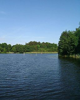
The Somerset Levels are a coastal plain and wetland area of Somerset, England, running south from the Mendips to the Blackdown Hills.

River Brue river in Somerset, United Kingdom

The River Brue originates in the parish of Brewham in Somerset, England, and reaches the sea some 50 kilometres (31 mi) west at Burnham-on-Sea. It originally took a different route from Glastonbury to the sea, but this was changed by Glastonbury Abbey in the twelfth century. The river provides an important drainage route for water from a low-lying area which is prone to flooding which man has tried to manage through rhynes, canals, artificial rivers and sluices for centuries.

Aquatic plant plant that has adapted to living in an aquatic environment

Aquatic plants are plants that have adapted to living in aquatic environments. They are also referred to as hydrophytes or macrophytes. A macrophyte is an aquatic plant that grows in or near water and is either emergent, submergent, or floating, and includes helophytes. In lakes and rivers macrophytes provide cover for fish and substrate for aquatic invertebrates, produce oxygen, and act as food for some fish and wildlife.

Related Research Articles

Damselfly suborder of insects

Damselflies are insects of the suborder Zygoptera in the order Odonata. They are similar to dragonflies, which constitute the other odonatan suborder, Anisoptera, but are smaller, have slimmer bodies, and most species fold the wings along the body when at rest. An ancient group, damselflies have existed since at least the Lower Permian, and are found on every continent except Antarctica.

Cotswold Water Park

The Cotswold Water Park is the United Kingdom's largest marl lake system, straddling the Wiltshire–Gloucestershire border, northwest of Cricklade and south of Cirencester. The lakes were created in the second half of the 20th century by extraction of glacial Jurassic limestone gravel, which had eroded from the Cotswold Hills, and these filled naturally after working began to cease in the early 1970s.

Edington, Somerset village in the United Kingdom

Edington is a rural village, situated on the north side of the Polden Hills in the Sedgemoor district of Somerset, England.

Biddle Street, Yatton

Biddle Street, Yatton is a 44.8 hectare biological Site of Special Scientific Interest (SSSI) near the village of Yatton in North Somerset, notified in 1994.

Norfolk damselfly species of insect

Norfolk damselfly or dark bluet is a species of blue damselfly of the family Coenagrionidae. This species acquired its common name from its discovery in 1903 and presence in a very restricted area of the Norfolk Broads. Records came from Sutton, Stalham, and Hickling Broads.

Yanal Bog

Yanal Bog is a 1.6 hectare biological Site of Special Scientific Interest on the southern edge of the North Somerset Levels, just north of the village of Sandford, North Somerset. It was notified as an SSSI in 1988.

Tickenham, Nailsea and Kenn Moors SSSI

Tickenham, Nailsea and Kenn Moors SSSI is a 129.4 hectare biological Site of Special Scientific Interest between Tickenham, Nailsea and Kenn on the North Somerset Levels, notified in 1995.

Catcott, Edington and Chilton Moors

Catcott, Edington and Chilton Moors SSSI is a 1083 hectare biological Site of Special Scientific Interest in Somerset, England notified in 1967. It is close to the villages of Edington and Catcott.

Curry and Hay Moors

Curry and Hay Moors is a 472.8 hectare biological Site of Special Scientific Interest in Somerset, notified in 1992.

Langmead and Weston Level

Langmead and Weston Level is a 168.8 hectare biological Site of Special Scientific Interest in Somerset, notified in 1991.

Moorlinch SSSI

Moorlinch is a 226.0 hectare biological Site of Special Scientific Interest at Moorlinch in Somerset, notified in 1985.

Southlake Moor

Southlake Moor is a 196.1 hectare biological Site of Special Scientific Interest near Burrow Mump and Burrowbridge in Somerset, notified in 1985.

West Moor SSSI

West Moor is a 213.0 hectare biological Site of Special Scientific Interest on the River Parrett in Somerset, notified in 1985.

West Sedgemoor area of the Somerset Levels, in Somerset, England


West Sedgemoor or West Sedge Moor is an area of the Somerset Levels, in Somerset, England, around 8 miles east of Taunton, which approximately coincides with the West Sedgemoor biological Site of Special Scientific Interest, a 1,016 hectare site notified as an SSSI in 1983. It is a flat, low-lying area of fields and meadows separated by water-filled rhynes and ditches. It is subject to controlled flooding in winter. It is drained by the River Parrett.

Laduviken

Laduviken is a lake in Norra Djurgården, a semi-rural area in north-eastern Stockholm, Sweden, forming part of the Royal National City Park. It is one of six lakes in Djurgården, the others being: Lillsjön, Uggleviken, Isbladskärret, Lappkärret, and Spegeldammen.

<i>Lestes dryas</i> species of insect

Lestes dryas is a species of damselfly in the family Lestidae, the spreadwings. Its common names include emerald spreadwing, scarce emerald damselfly and robust spreadwing. An alternate name in Ireland is the turlough spreadwing.

Decoy Pit, Pools and Woods

Decoy Pit, Pools and Woods is a 20.27 hectares Site of Special Scientific Interest (SSSI) at Aldermaston Wharf in the civil parish of Aldermaston in the English county of Berkshire, notified in 1993.

Glemsford Pits

Glemsford Pits is a 37.5 hectare biological Site of Special Scientific Interest south of Glemsford in Suffolk. The River Stour, which forms the boundary between Suffolk and Essex, runs through the site, which is thus in both counties.

References

  1. "Tealham and Tadham Moors" (PDF). English Nature . Retrieved 2006-08-21.