Related Research Articles

Castleton is a village in the High Peak district of Derbyshire, England, at the western end of the Hope Valley on the Peakshole Water, a tributary of the River Noe, between the Dark Peak to the north and the White Peak to the south. The population was 642 at the 2011 Census.

Hathersage is a village and civil parish in the Peak District in Derbyshire, England. It lies slightly to the north of the River Derwent, approximately 10 miles (16.1 km) south-west of Sheffield.

The history of Derbyshire can be traced back to human settlement since the last Ice Age, over 10,000 years ago. The county of Derbyshire in England dates back to the 11th century.

The Limestone Way is a waymarked long-distance footpath in Derbyshire, England. It runs for 46 miles (74 km) through the White Peak of the Peak District National Park, from Castleton south to Rocester over the county boundary into Staffordshire. The trail is named for the limestone scenery along its route. It was devised by Brian Spencer of Matlock Rotary Club and developed and opened in 1986 by the West Derbyshire District Council. It originally ran to Matlock, but was extended to its current, longer route in 1992 to join up with the Staffordshire Way.
Barton Blount is a village and civil parish in the South Derbyshire district of Derbyshire, England, between Derby and Uttoxeter. According to the 2001 census it had a population of 74. The population remained at fewer than 100 for the 2011 Census. Details are included in the civil parish of Church Broughton.

Bradwell is a village and civil parish in the Derbyshire Peak District of England. The population of the civil parish taken at the 2011 Census was 1,416. It lies south of the main body of the Hope Valley but is usually included among its settlements.

Odin Mine is a disused lead mine in the Peak District National Park, situated at grid reference SK133835. It lies on a site of 25 hectares near the village of Castleton, England. It is the oldest documented mine in Derbyshire and is thought to be one of the oldest lead mines in England. The mine is a Scheduled Ancient Monument and has biological and geological significance within the Castleton Site of Special Scientific Interest.

Eldon Hill is a hill in the Peak District National Park in the county of Derbyshire, England, 4 kilometres (2.5 mi) southwest of the village of Castleton. It is a 470-metre (1,540 ft) limestone hill whose pastureland is used for rough grazing, although a large proportion has been lost to limestone quarrying. It lies within the Castleton Site of Special Scientific Interest. Eldon Hill was formed when a bed of pure limestone was squeezed and upfolded by geological forces to form a dome; it is the highest limestone hill north of the River Wye.

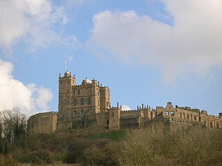
Peveril Castle is a ruined 11th-century castle overlooking the village of Castleton in the English county of Derbyshire. It was the main settlement of the feudal barony of William Peverel, known as the Honour of Peverel, and was founded some time between the Norman Conquest of 1066 and its first recorded mention in the Domesday Survey of 1086, by Peverel, who held lands in Nottinghamshire and Derbyshire as a tenant-in-chief of the king. The town became the economic centre of the barony. The castle has views across the Hope Valley and Cave Dale.

This is a list of scheduled monuments in the Borough of Erewash in the English county of Derbyshire.
This is a list of scheduled monuments in the district of Amber Valley in the English county of Derbyshire.
This is a list of scheduled monuments in the district of Bolsover in the English county of Derbyshire.
This is a list of scheduled monuments in the district of High Peak in the English county of Derbyshire.
This is a list of scheduled monuments in the district of North East Derbyshire in the English county of Derbyshire.
This is a list of scheduled monuments in the district of South Derbyshire in the English county of Derbyshire.

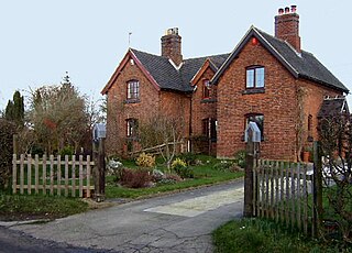
Castleton Hall is an 18th-century grade II listed country hall on Castle Street in Castleton, Derbyshire.

Losehill Hall is a 19th-century grade II listed country hall on Squires Lane on the outskirts of Castleton, Derbyshire.

Cryer House is a 17th-century grade II listed country hall on Castle Street in Castleton, Derbyshire.

The Castleton town defences in Castleton, Derbyshire, consist of a ditch and bank constructed during the 1190s. The ditch was part of Peveril Castle's medieval defence system.
References
- ↑ Historic England. "Medieval hospital 530m south east of Losehill Hall (1018869)". National Heritage List for England . Retrieved 8 February 2024.
- ↑ "Medieval hospital 530m south east of Losehill Hall, Castleton - 1018869 | Historic England". historicengland.org.uk. Retrieved 8 February 2024.
- ↑ Stuff, Good. "Medieval hospital 530m south east of Losehill Hall, Castleton, Derbyshire". ancientmonuments.uk. Retrieved 8 February 2024.
- ↑ "MDR2316 - Medieval Hospital (site of), Castleton Road, Castleton - Derbyshire Historic Environment Record". her.derbyshire.gov.uk. Retrieved 8 February 2024.