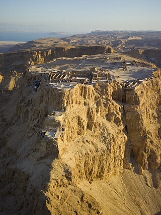
Masada is an ancient fortification in southern Israel, situated on top of an isolated rock plateau, akin to a mesa. It is located on the eastern edge of the Judaean Desert, overlooking the Dead Sea 20 km east of Arad.

A defensive wall is a fortification usually used to protect a city, town or other settlement from potential aggressors. The walls can range from simple palisades or earthworks to extensive military fortifications such as curtain walls with towers, bastions and gates for access to the city. From ancient to modern times, they were used to enclose settlements. Generally, these are referred to as city walls or town walls, although there were also walls, such as the Great Wall of China, Walls of Benin, Hadrian's Wall, Anastasian Wall, and the Atlantic Wall, which extended far beyond the borders of a city and were used to enclose regions or mark territorial boundaries. In mountainous terrain, defensive walls such as letzis were used in combination with castles to seal valleys from potential attack. Beyond their defensive utility, many walls also had important symbolic functions – representing the status and independence of the communities they embraced.

Ajdovščina is a town in the Vipava Valley, Slovenia. It is the administrative seat of the Municipality of Ajdovščina.

Emona or Aemona was a Roman castrum, located in the area where the navigable Nauportus River came closest to Castle Hill, serving the trade between the city's settlers – colonists from the northern part of Roman Italy – and the rest of the empire. Emona was the region's easternmost city, although it was assumed formerly that it was part of the Pannonia or Illyricum, but archaeological findings from 2008 proved otherwise. From the late 4th to the late 6th century, Emona was the seat of a bishopric that had intensive contacts with the ecclesiastical circle of Milan, reflected in the architecture of the early Christian complex along Erjavec Street in present-day Ljubljana.

Eboracum was a fort and later a city in the Roman province of Britannia. In its prime it was the largest town in northern Britain and a provincial capital. The site remained occupied after the decline of the Western Roman Empire and ultimately developed into the present-day city of York, in North Yorkshire, England.

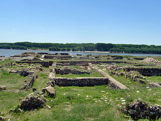
Novae was initially one of the few great Roman legionary fortresses along the empire's border, forming part of the defences along the Danube in northern Bulgaria. The settlement later expanded into a town in the Roman province of Moesia Inferior, later Moesia Secunda.

Ir Ovot is a small village in southern Israel. Located in the northeastern Arabah, it falls under the jurisdiction of Central Arava Regional Council. It operated as a kibbutz from 1967 until the 1980s. In 2019 it had a population of 54.
Located in Turkey, the settlement of Satala, according to the ancient geographers, was situated in a valley surrounded by mountains, a little north of the Euphrates, where the road from Trapezus to Samosata crossed the boundary of the Roman Empire, when it was a bishopric, which remains a Latin Catholic titular see. Later it was connected with Nicopolis by two highways. Satala is now Sadak, a village of 348 inhabitants (2022), in the Kelkit District of Gümüşhane Province in Turkey.
The Limes Arabicus was a desert frontier of the Roman Empire, running north from its start in the province of Arabia Petraea. It ran northeast from the Gulf of Aqaba for about 1,500 kilometers (930 mi) at its greatest extent, reaching northern Syria and forming part of the wider Roman limes system. It had several forts and watchtowers.

Dinogetia was an ancient Geto-Dacian settlement and later Roman fort located not far from the right (southern) bank of the Danube near the junction of the Siret River. The Dinogetia site is situated in Northern Dobruja, Romania, 8 km east of Galați and 2 km north of Garvăn, a village in Jijila commune.

Sucidava was a Dacian and Daco-Roman city situated in Corabia, Romania, on the north bank of the Danube. It developed from the 270s AD and especially after the construction of Constantine's Bridge the northern side of which it protected.

The Vipava Valley is a valley in the Slovenian Littoral, roughly between the village of Podnanos to the east and the border with Italy to the west. The main towns are Ajdovščina and Vipava.
Povir is a village in the Municipality of Sežana in the Littoral region of Slovenia. It includes the hamlets of Britof, Dulanja Vas, and Guranja Vas.

Col is a settlement on the edge of a karst plateau overlooking the Vipava Valley in the Municipality of Ajdovščina in the traditional Inner Carniola region of Slovenia. It is now generally regarded as part of the Slovenian Littoral. A Roman road led through the settlement. Its location overlooking the valley on the main route leading inland was used in the Middle Ages and later as a checkpoint between the Littoral region and Carniola. Trilek Castle is located on the eastern outskirts of the village.

Stomaž is a village in the hills north of the Vipava Valley in the Municipality of Ajdovščina in the Littoral region of Slovenia. It is made up of several smaller hamlets: Brith, Dolenja Vas, Hrib, Ljubljanica, Griže, Črnigoji, Bratini, and Batagelji.
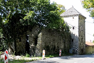
Trilek Castle, also known as Old Castle, is a small castle or fort in the settlement of Col, in the Municipality of Ajdovščina in southwest Slovenia. Built in the early 16th century, it was first mentioned in the 17th-century historian Johann Weikhard von Valvasor's 1689 survey The Glory of the Duchy of Carniola.
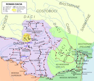
Limes Transalutanus is the modern name given to a fortified frontier system of the Roman Empire, built on the western edge of Teleorman's forests as part of the Dacian Limes in the Roman province of Dacia, modern-day Romania.

Claustra Alpium Iuliarum was a defense system within the Roman Empire between Italia and Pannonia that protected Italy from possible invasions from the East. It secured the Postojna Gate, the land link between the eastern and western part of the empire, and thus the Claustra represented an inner border defense of the empire. Unlike a linear rampart, the Claustra consisted of a series of interconnected fortifications with its center at Castra ad Fluvium Frigidum ; other important fortresses were Ad Pirum on today's Hrušica Plateau and Tarsatica, now a part of the city of Rijeka. They had been governed from the town of Aquileia.
Capidava was originally an important Geto-Dacian centre on the right bank of the Danube. After the Roman conquest, it became a civil and military centre in the province of Moesia Inferior and part of the defensive frontier system of the Moesian Limes along the Danube.

Ayaz-Kala is an archaeological site in Ellikqala District, Karakalpakstan, in northern Uzbekistan, built between the 4th century BCE and the 7th century CE. Situated on a hilltop overlooking the Kyzylkum Desert, the site encompasses the ruins of an ancient Khorezm fortress.


