Catawissa Railroad

Last updated
Catawissa Railroad
Catawissa Railroad
High Bridge at Mainville PA - Catawissa RR 1860s.png
Bridge at Mainville, Pennsylvania, 1860s
Overview
Headquarters Philadelphia
Locale Lycoming, Montour, Northumberland, Columbia and Schuylkill Counties, Pennsylvania
Dates of operation18601953
PredecessorCatawissa, Williamsport and Erie Railroad
Successor Reading Company
Technical
Track gauge 4 ft 8+12 in (1,435 mm) standard gauge
Length98.5 miles (158.5 km)

The Catawissa Railroad was a railroad that operated in Pennsylvania between 1860 and 1953. For most of its lifespan it was leased by the Reading Company, and was subsequently merged into the Reading.

Contents

History

Catawissa Railroad map as of 1895 Catawissa RR map 1895.jpg
Catawissa Railroad map as of 1895

The original company was chartered as the Little Schuylkill and Susquehanna Railroad in 1831. [1] It planned to build a rail line between Tamanend (also called Little Schuylkill Junction; west of Tamaqua) and Milton. The principals in the company included Christian Brobst and Joseph Paxton of Catawissa. Construction began c. 1835, but the banking panic of 1837 restricted investments needed to continue work on the railroad. [2] [3]

In 1849 the company reorganized, to attract new investors, and became the Catawissa, Williamsport and Erie Railroad (CW&E). In the early 1850s construction resumed, and in 1854 the railroad reached Milton, where it connected with the Sunbury and Erie Railroad (renamed the Philadelphia and Erie in 1861). At Tamanend the railroad connected with the Little Schuylkill Navigation Railroad, which ran along the Little Schuylkill River to Tamaqua and Port Clinton, where it connected to the Reading Company. CW&E passenger train operations between Catawissa and Tamaqua began in July 1854. A bridge across the Susquehanna River to Rupert was completed in 1855. [2] The 65 miles (105 km) route traversed some difficult terrain, and included three tunnels, and eight bridges and trestles. [4]

Express train service from Philadelphia to Buffalo, Niagara Falls and Chicago began on 7 May 1855, using the CW&E, as well as the Reading and Little Schuylkill Navigation lines. [5]

The CW&E went bankrupt in 1859, and reorganized as the Catawissa Railroad (CRR) in 1860. In 1865 the Western Central Railroad and the Atlantic and Great Western Railroad attempted to lease the Catawissa RR. The leases were challenged by the Philadelphia & Erie in litigation, and eventually they were upheld by the Pennsylvania Supreme Court. However, the A&GW declared bankruptcy in 1867, and the CRR then proceeded to operate the line by itself. [5] As of 1868 the company owned 21 locomotives and 269 cars. [6]

The company built an engine house and machine shop in Catawissa, on land donated by the town, in 1861. Other support buildings were added to the 12-acre site through 1901. A passenger station was erected in 1878. [4] [5]

In 1871 the Catawissa Railroad extended its main line from Milton to Williamsport. The Reading Company leased the Catawissa lines in 1872. In 1893 the CRR lines were consolidated with the Reading's Shamokin Branch. [7]

The CRR was formally merged with the Reading Company in 1953. [8] The Reading abandoned various sections of the Catawissa Branch later in the 1950s, through the 1960s. [9] In 1976 the Reading was acquired by Conrail, which abandoned the remaining portions of the Catawissa Branch. [10]

Bridges

The railroad's bridge over Dark Run was 546 feet (166 m) high and 574 feet (175 m) long. The bridge at Mainville, the only one in Columbia County, was 115 feet (35 m) high and 727 feet (222 m) long. [11]

See also

Related Research Articles

<span class="mw-page-title-main">Schuylkill County, Pennsylvania</span> County in Pennsylvania, United States

Schuylkill County is a county in the Commonwealth of Pennsylvania. It is located in the heart of Pennsylvania's Coal Region and is part of Northeastern Pennsylvania. As of the 2020 census, the population was 143,049. The county seat is Pottsville.

<span class="mw-page-title-main">Mainville, Pennsylvania</span> Census-designated place in Pennsylvania, United States

Mainville is a census-designated place in Columbia County, Pennsylvania, United States. It is part of Northeastern Pennsylvania. The population was 134 at the 2020 census. It is part of the Bloomsburg-Berwick micropolitan area.

<span class="mw-page-title-main">Rush Township, Schuylkill County, Pennsylvania</span> Township in Pennsylvania, United States

Rush Township is a township in Schuylkill County, Pennsylvania, United States. The population was 3,423 at the 2020 census. The township is served by Tamaqua Area School District and Mahanoy Area School District.

<span class="mw-page-title-main">Union Canal (Pennsylvania)</span> United States historic place

The Union Canal was a towpath canal that existed in southeastern Pennsylvania in the United States during the 19th century. First proposed in 1690 to connect Philadelphia with the Susquehanna River, it ran approximately 82 mi from Middletown on the Susquehanna below Harrisburg to Reading on the Schuylkill River.

<span class="mw-page-title-main">Reading Company</span> Defunct transport company

The Reading Company was a Philadelphia-headquartered railroad that provided passenger and freight transport in eastern Pennsylvania and neighboring states from 1924 until its acquisition by Conrail in 1976.

<span class="mw-page-title-main">Main Line of Public Works</span> United States historic place

The Main Line of Public Works was a package of legislation passed by the Commonwealth of Pennsylvania in 1826 to establish a means of transporting freight between Philadelphia and Pittsburgh. It funded the construction of various long-proposed canal and road projects, mostly in southern Pennsylvania, that became a canal system and later added railroads. Built between 1826 and 1834, it established the Pennsylvania Canal System and the Allegheny Portage Railroad.

<span class="mw-page-title-main">Lehigh and Mahanoy Railroad</span>

The Lehigh and Mahanoy Railroad, originally the Quakake Railroad, was a rail line connecting Black Creek Junction in the Lehigh Valley region of eastern Pennsylvania with Quakake, Delano, and Mount Carmel. Opened from Black Creek Junction to Quakake in 1858 and to Mount Carmel in 1860, it allowed anthracite coal mined along the line and bridge traffic to be transported east tos New York City. After 1866, it was merged into the Lehigh Valley Railroad and named Mahanoy Branch.

The Lehigh and New England Railroad was a Class I railroad located in Northeastern United States that acted as a bridge line. It was the second notable U.S. railroad to file for abandonment in its entirety after the New York, Ontario and Western Railway. It was headquartered in Philadelphia.

<span class="mw-page-title-main">Catawissa Creek</span> Tributary of the Susquehanna River in Pennsylvania

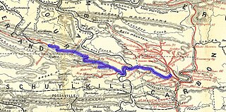
Catawissa Creek is a 41.8-mile-long (67.3 km) tributary of the Susquehanna River in east-central Pennsylvania in the United States. Its watershed has an area of 153 square miles (400 km2).

<span class="mw-page-title-main">Lycoming Valley Railroad</span> Pennsylvania railroad

The Lycoming Valley Railroad is a short line that operates 38 miles (61 km) of track in Lycoming and Clinton counties in Pennsylvania in the United States. It is part of the North Shore Railroad System.

<span class="mw-page-title-main">Union County Industrial Railroad</span>

The Union County Industrial Railroad is a short line railroad that operates on approximately 12 miles (20 km) of track in Union County in the U.S. State of Pennsylvania. It is part of the North Shore Railroad System.

<span class="mw-page-title-main">Pennsylvania Canal</span> Former canal network in Pennsylvania

The Pennsylvania Canal, sometimes known as the Pennsylvania Canal system, was a complex system of transportation infrastructure improvements, including canals, dams, locks, tow paths, aqueducts, and viaducts. The canal was constructed and assembled over several decades beginning in 1824, the year of the first enabling act and budget items.

<span class="mw-page-title-main">Roaring Creek (Pennsylvania)</span> Tributary of the Susquehanna River

Roaring Creek is a tributary of the Susquehanna River in Columbia County and Montour County, in Pennsylvania, in the United States. It is slightly more than 20 miles (32 km) long and flows through Roaring Creek Township, Locust Township, Catawissa Township, Cleveland Township, and Franklin Township in Columbia County and Mayberry Township in Montour County. The watershed of the creek has an area of 87.3 square miles (226 km2). It has three named tributaries: South Branch Roaring Creek, Lick Run, and Mill Creek. The creek is not considered to be impaired and is not affected by coal mining. However, its watershed has been impacted by human land use. Claystones, conglomerates, sandstones, siltstones, and shales all occur within the watershed. The creek flows through a gorge in its lower reaches, along the border between Columbia County and Montour County.

<span class="mw-page-title-main">Barnesville, Pennsylvania</span> Unincorporated community in Pennsylvania, United States

Barnesville is an unincorporated community in Ryan Township, Pennsylvania, United States. Originally built to support nearby rust belt industries, the hamlet is between the center and eastern thirds of the Southern Anthracite Coal Region. The community is part of a wide-ranging township and is situated atop a summit and drainage divide flanked by two long climbs that are traversed by local transport infrastructure, railways with an important switching junction within the village, and Pennsylvania Route 54, which collects towns like beads on a string along a particular combination of connected valleys in the Ridge-and-Valley Appalachians.

The Lehigh Coal and Navigation Company (LCAN) (1988–2010) was a modern-day anthracite coal mining company headquartered in Pottsville, Pennsylvania. It acquired many properties and relaunched the Lehigh Coal Companies brand in 1988. The LCAN ran strip mining operations in the Panther Creek Valley east of Lansford, Pennsylvania along U.S. Route 209 with vast properties dominating the coal areas of Tamaqua, Coaldale, and Lansford.

The Little Schuylkill Navigation, Railroad and Coal Company (LSRR) was a railway company in the U.S. state of Pennsylvania in the 19th century. The main line ran from Port Clinton to Tamaqua, for a total of 28 miles (45 km).

<span class="mw-page-title-main">Nesquehoning Valley Railroad</span> Nesquehoning Valley Railroad: USA

The Nesquehoning Valley Railroad Company, herein called the Nesquehoning Valley Railroad (NVRR), is now a fallen flag standard-gauge, steam era shortline railroad built as a coal road to ship the Anthracite mined in the Southeastern Coal Region on either side of the Little Schuylkill River tributary Panther Creek and the history making coal towns of the Panther Creek Valley down the Lehigh River transportation corridor to the Eastern seaboard.

<span class="mw-page-title-main">Catawissa Mountain</span> Mountain in the state of Pennsylvania

Catawissa Mountain is a mountain in Columbia County, Pennsylvania, in the United States. Its peak height is 1,873 feet (571 m) above sea level, making it the fifth-highest mountain in Columbia County. Streams that flow near the mountain include Roaring Creek, Catawissa Creek, and some of their tributaries. The mountain is near Nescopeck Mountain and Little Mountain. Sandstones and rock formations such as the Pocono Formation occur on Catawissa Mountain.

References

  1. Not to be confused with the Little Schuylkill Navigation, Railroad and Coal Company, operating between Tamaqua and Port Clinton.
  2. 1 2 Columbia County Historical and Genealogical Society (March 2006). "Catawissa Railroad, 1825-1896" (PDF). Newsletter. Bloomsburg, PA. Archived from the original (PDF) on 2011-12-09.
  3. Lewis, William D.; et al. (1853). The Catawissa, Williamsport and Erie Rail-Road. New York: J. H. Burnet, Stationer. p.  1.
  4. 1 2 "Catawissa RR History". caboosenut.com (Walter Gosciminski). Retrieved 2017-07-22.
  5. 1 2 3 Heydinger, Earl J. (April 1963). "GROUP VI: The Little Schuylkill". Railway and Locomotive Historical Society Bulletin . Railroads of the First and Second Anthracite Coal Fields of Pennsylvania. 108: 19–28. JSTOR   43518064. Archived from the original on 2016-08-16. Retrieved 2011-11-09.
  6. Poor, Henry V. (1868). Manual of the Railroads of the United States, for 1868-69. New York: H. V. & H. W. Poor. p. 252.
  7. Historical and Biographical Annals of Columbia and Montour Counties Pennsylvania. Vol. I. Chicago: J. H. Beers & Co. 1915. p. 47.
  8. "Union County Industrial Railroad". Northumberland, PA: North Shore Railroad Company. Archived from the original on 2009-04-18. Retrieved 2011-11-08.
  9. "Catawissa Branch: ICC Abandonment Filings". AbandonedRails.com. Retrieved 2012-01-13.
  10. "Reading Company Mainline". thebluecomet.com. Archived from the original on 2012-04-20. Retrieved 2012-01-16.
  11. "View source for Page:Historical and Biographical Annals of Columbia and Montour Counties, Pennsylvania, Containing a Concise History of the Two Counties and a Genealogical and Biographical Record of Representative Families.djvu/76 - Wikisource, the free online library".