Columbia County, Pennsylvania

Last updated

Columbia County
County
Columbia County, Pennsylvania court house.JPG
The Columbia County courthouse in Bloomsburg
Map of Pennsylvania highlighting Columbia County.svg
Location within the U.S. state of Pennsylvania
Pennsylvania in United States.svg
Pennsylvania's location within the U.S.
Coordinates: 41°03′N76°24′W / 41.05°N 76.4°W / 41.05; -76.4
CountryFlag of the United States.svg United States
StateFlag of Pennsylvania.svg  Pennsylvania
FoundedMarch 22, 1813
Named for Christopher Columbus
Seat Bloomsburg
Largest townBloomsburg
Area
  Total490 sq mi (1,300 km2)
  Land483 sq mi (1,250 km2)
  Water7.1 sq mi (18 km2)  1.4%
Population
 (2020)
  Total64,727
  Density130/sq mi (51/km2)
Time zone UTC−5 (Eastern)
  Summer (DST) UTC−4 (EDT)
Congressional district 9th
Website www.columbiapa.org
DesignatedJuly 11, 1983 [1]

Columbia County is a county in the Commonwealth of Pennsylvania. It is located in Northeastern Pennsylvania. As of the 2020 census, the population was 64,727. [2] Its county seat is Bloomsburg. [3] The county was created on March 22, 1813, from part of Northumberland County. It was named Columbia, alluding to the United States and Christopher Columbus. The county is part of the Central Pennsylvania region of the state. [lower-alpha 1]

Contents

Columbia County is part of the Bloomsburg-Berwick, PA Metropolitan Statistical Area.

Geography

View of northern Columbia County, Pennsylvania from Kramer Hill Road in Fishing Creek Township. On the horizon (about 8-10 miles away) is North Mountain. The borough of Benton is in the center of the picture. View of northern Columbia County, Pennsylvania from Kramer Hill Road 3.JPG
View of northern Columbia County, Pennsylvania from Kramer Hill Road in Fishing Creek Township. On the horizon (about 8-10 miles away) is North Mountain. The borough of Benton is in the center of the picture.

According to the U.S. Census Bureau, the county has a total area of 490 square miles (1,300 km2), of which 483 square miles (1,250 km2) is land and 7.1 square miles (18 km2) (1.4%) is water. [4] The southern tip of Columbia County is part of the Coal Region. The area of the county from the Susquehanna River south to several miles south of Numidia consists mostly of farmland and state game lands. Several communities developed along the Susquehanna River, such as Bloomsburg and Catawissa. From the Susquehanna River north as far as Waller, the county is mostly farmland with several patches of forest. North of Waller, the county is mostly state game lands and mountains. [5]

The major streams in Columbia County are the Susquehanna River, Fishing Creek, Briar Creek, Catawissa Creek, and Roaring Creek. [5]

The county has a humid continental climate (Dfa/Dfb) and average monthly temperatures in Bloomsburg average from 26.9 °F or −2.8 °C in January to 72.4 °F or 22.4 °C in July. [6]

Mountains

Note: Only mountains higher than 1,500 feet (460 m) are listed

NameHeightImage
Red Rock Mountain 2,365 feet (721 m) Red rock mountain.jpg
Central Mountain 2,247 feet (685 m)
Chimneystack Rock2,244 feet (684 m)
Buck Mountain 1,942 feet (592 m) Buck Mountain from Buck Mountain Road.JPG
Catawissa Mountain 1,873 feet (571 m) Northwestern edge of Catawissa Mountain.JPG
Big Mountain1,811 feet (552 m)
Knob Mountain 1,752 feet (534 m) Knob Mountain from the southwest 2.JPG
Nescopeck Mountain 1,604 feet (489 m) Nescopeck Mountain 1.JPG
Lee Mountain1,594 feet (486 m) Lee Mountain in Briar Creek Township, Columbia County, Pennsylvania.JPG
McCauley Mountain 1,571 feet (479 m) McCauley Mountain 2.JPG

Source: [7] [8]

Major highways

Adjacent counties

State park

Part of Ricketts Glen State Park is in the northern portion of Columbia County. [9]

Demographics

Historical population
CensusPop.Note
1820 17,621
1830 20,05913.8%
1840 24,26721.0%
1850 17,710−27.0%
1860 25,06541.5%
1870 28,76614.8%
1880 32,40912.7%
1890 36,83213.6%
1900 39,8968.3%
1910 48,46721.5%
1920 48,349−0.2%
1930 48,8030.9%
1940 51,4135.3%
1950 53,4604.0%
1960 53,4890.1%
1970 55,1143.0%
1980 61,96712.4%
1990 63,2022.0%
2000 64,1481.5%
2010 67,2954.9%
2020 64,727−3.8%
[10]

As of the census [11] of 2000, there were 64,151 people, 24,915 households, and 16,568 families residing in the county. The population density was 132 inhabitants per square mile (51/km2). There were 27,733 housing units at an average density of 57 units per square mile (22/km2). The racial makeup of the county was 97.59% White, 0.80% Black or African-American, 0.15% Native American, 0.52% Asian, 0.03% Pacific Islander, 0.33% from other races, and 0.58% from two or more races. 0.95% of the population were Hispanic or Latino of any race. 33.2% were of German, 10.0% American, 9.4% Irish, 8.1% Italian, 6.7% Polish and 6.2% English ancestry.

There were 24,915 households, out of which 27.70% had children under the age of 18 living with them, 53.80% were married couples living together, 8.70% had a female householder with no husband present, and 33.50% were non-families. 26.60% of all households were made up of individuals, and 11.80% had someone living alone who was 65 years of age or older. The average household size was 2.42 and the average family size was 2.90.

In the county, the population was spread out, with 20.80% under the age of 18, 14.30% from 18 to 24, 25.90% from 25 to 44, 23.10% from 45 to 64, and 15.90% who were 65 years of age or older. The median age was 38 years. For every 100 females, there were 90.80 males. For every 100 females age 18 and over, there were 87.80 males.

2020 census

Columbia County Racial Composition [12]
RaceNum.Perc.
White (NH)58,83191%
Black or African American (NH)8671.34%
Native American (NH)710.11%
Asian (NH)7481.15%
Pacific Islander (NH)170.03%
Other/Mixed (NH)2,0533.17%
Hispanic or Latino 2,1403.31%

Metropolitan Statistical Area

The United States Office of Management and Budget [13] has designated Columbia County as the Bloomsburg-Berwick, PA Metropolitan Statistical Area (MSA). As of the 2010 census [14] the metropolitan area ranked 20th most populous in the State of Pennsylvania and the 368th most populous in the United States with a population of 82,562. Columbia County is also a part of the larger Bloomsburg-Berwick-Sunbury, PA Combined Statistical Area (CSA), which combines the populations of Columbia County as well as Montour, Northumberland, Snyder and Union Counties in Pennsylvania. The Combined Statistical Area ranked 8th in the State of Pennsylvania and 115th most populous in the United States with a population of 264,739.

Politics and government

United States presidential election results for Columbia County, Pennsylvania [15]
Year Republican Democratic Third party
No.%No.%No.%
2020 20,09864.25%10,53233.67%6502.08%
2016 18,00463.16%8,93431.34%1,5685.50%
2012 14,23655.30%10,93742.48%5712.22%
2008 14,47751.20%13,23046.79%5712.02%
2004 16,05259.74%10,67939.74%1380.51%
2000 12,09555.20%8,97540.96%8413.84%
1996 8,23440.42%8,37941.13%3,75918.45%
1992 9,74241.04%8,26134.80%5,73624.16%
1988 12,11460.51%7,76738.79%1400.70%
1984 14,40263.39%8,25436.33%620.27%
1980 12,42653.30%9,44940.53%1,4386.17%
1976 11,50848.10%12,05150.37%3661.53%
1972 14,18763.59%7,22232.37%9004.03%
1968 12,20254.89%8,18736.83%1,8408.28%
1964 8,98239.22%13,88560.63%360.16%
1960 15,31062.11%9,32237.82%190.08%
1956 13,38259.69%9,02440.25%150.07%
1952 13,00857.67%9,46741.97%790.35%
1948 9,41750.13%9,36749.87%00.00%
1944 9,33649.00%9,64750.63%700.37%
1940 9,51843.05%12,52356.65%660.30%
1936 9,67440.13%14,14158.66%2931.22%
1932 8,79144.43%10,64053.77%3561.80%
1928 14,36272.61%5,30426.81%1150.58%
1924 7,33647.42%7,39047.77%7434.80%
1920 6,23845.65%6,96550.97%4623.38%
1916 3,01332.80%5,78562.97%3894.23%
1912 8899.98%4,90555.05%3,11634.97%
1908 3,71839.17%5,37356.60%4024.23%
1904 3,63544.08%4,19650.89%4155.03%
1900 2,95435.21%4,98259.38%4545.41%
1896 3,28037.77%4,90456.47%5005.76%
1892 2,33630.56%4,92964.47%3804.97%
1888 2,48433.38%4,67662.84%2813.78%

Voter registration

As of February 6, 2024, there were 39,054 registered voters in Columbia County. [16]

Chart of Voter Registration

   Republican (53.31%)
   Democratic (31.41%)
   Independent (11.16%)
   Other Parties (4.11%)

While the county registration tends to be evenly matched between Democrats and Republicans, the county trends Republican in statewide elections. Donald Trump carried the county by more than 30 points in both 2016 and 2020. While John McCain received 51.6% of its vote to 47.1% for Barack Obama, this was a far-closer margin than the 20 points that George W. Bush carried it by in 2004. Each of the three row-office statewide winners carried Columbia in 2008. In 2006, Democrat Bob Casey Jr. received 51% of its vote when he unseated incumbent Republican US Senator Rick Santorum and Ed Rendell received 50.6% of the vote against Lynn Swann.

For many years Columbia County was represented in the State House by a conservative Democrat in the 109th district until John Gordner changed parties to Republican in 2001. He was elected to the State Senate in 2003 and succeeded by Republican David R. Millard. Columbia is in the 27th Senate district and 11th Congressional district.

County commissioners

CommissionersParty
David Kovach Democratic
Rich Ridgway Republican
Chris Young Republican

Other county officials

OfficeOfficialParty
Chief JudgeThomas A. James Democratic
JudgeGary Norton Republican
Chief ClerkGail Kipp Democratic
CoronerJeremy Reese Republican
Recorder of Deeds and Register of WillsBeverly Michael Democratic
SheriffTim Chamberlain Democratic
TreasurerShirley Turner Republican
Clerk of Courts and ProthonotaryTami B. Kline Republican

State senate

DistrictSenatorParty
27 John Gordner Republican

State House of Representatives

DistrictRepresentativeParty
107 Kurt Masser Republican
109 David R. Millard Republican
117 Karen Boback Republican

United States House of Representatives

DistrictRepresentativeParty
9 Dan Meuser Republican

United States Senate

SenatorParty
Bob Casey Democrat
John Fetterman Democrat

Education

Map of Columbia County, Pennsylvania School Districts Map of Columbia County Pennsylvania School Districts.png
Map of Columbia County, Pennsylvania School Districts

Colleges and universities

Public school districts

Technical school

Charter school

Private schools

Libraries

Communities

Map of Columbia County, Pennsylvania with Municipal Labels showing Towns and Boroughs (red), Townships (white), and Census-designated places (blue). Map of Columbia County Pennsylvania With Municipal and Township Labels.png
Map of Columbia County, Pennsylvania with Municipal Labels showing Towns and Boroughs (red), Townships (white), and Census-designated places (blue).

Under Pennsylvania law, there are four types of incorporated municipalities: cities, boroughs, townships, and, in at most two cases, towns. The following town, boroughs and townships are located in Columbia County:

Town

Boroughs

Townships

Census-designated places

Census-designated places are geographical areas designated by the U.S. Census Bureau for the purposes of compiling demographic data. They are not actual jurisdictions under Pennsylvania law. Other unincorporated communities, such as villages, may be listed here as well.

Unincorporated communities

Population ranking

The population ranking of the following table is based on the 2010 census of Columbia County. [14]

county seat

RankCity/Town/etc.Municipal typePopulation (2010 Census)
1Bloomsburg Town14,855
2 Berwick Borough10,477
3 Ashland (mostly in Schuylkill County)Borough2,817
4 Espy CDP1,642
5 Catawissa Borough1,552
6 Mifflinville CDP1,253
7 Lightstreet CDP1,093
8 Almedia CDP1,078
9 Millville Borough948
10 Lime Ridge CDP890
11 Benton Borough824
12 Briar Creek Borough660
13 Fernville CDP556
14 Orangeville Borough508
15 Buckhorn CDP318
16 Aristes CDP311
17 Foundryville CDP256
18 Numidia CDP244
19 Stillwater Borough209
20 Wilburton Number One CDP196
21 Jerseytown CDP184
22 Rupert CDP183
23 Locustdale (partially in Schuylkill County)CDP177
24 Slabtown CDP156
25 Rohrsburg CDP145
26 Iola CDP144
27 Jamison City CDP134
28 Mainville CDP132
29 Eyers Grove CDP105
30 Wilburton Number Two CDP96
31 Jonestown CDP64
32 Waller CDP48
33 Centralia Borough10

See also

Related Research Articles

<span class="mw-page-title-main">Union County, Pennsylvania</span> County in Pennsylvania, United States

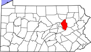
Union County is a county in the Commonwealth of Pennsylvania. As of the 2020 census, the population was 42,681. Its county seat is Lewisburg. The county was created on March 22, 1813, from part of Northumberland County. Its name is an allusion to the federal Union. Mifflinburg was established by legislation as the first county seat until it was moved to New Berlin in 1815. Lewisburg became county seat in 1855 and has remained so since. Union County comprises the Lewisburg, PA Micropolitan Statistical Area, which is also included in the Bloomsburg-Berwick-Sunbury, PA Combined Statistical Area. The county is part of the Central Pennsylvania region of the state.

<span class="mw-page-title-main">Snyder County, Pennsylvania</span> County in Pennsylvania, United States

Snyder County is a county in the Commonwealth of Pennsylvania. As of the 2020 census, the population was 39,736. The county seat is Middleburg. Snyder County was formed in 1855 from parts of Union County. The county is part of the Central Pennsylvania region of the state.

<span class="mw-page-title-main">Northumberland County, Pennsylvania</span> County in Pennsylvania, United States

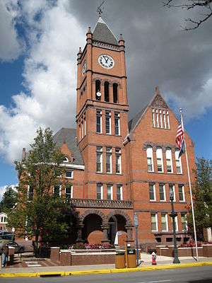
Northumberland County is a county in the Commonwealth of Pennsylvania. As of the 2020 census, the population was 91,647. Its county seat is Sunbury. The county is part of the Central Pennsylvania region of the state.

<span class="mw-page-title-main">Montour County, Pennsylvania</span> County in Pennsylvania, United States

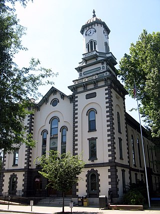
Montour County is a county in the Commonwealth of Pennsylvania. As of the 2020 census, the population was 18,136. Its county seat is Danville. The county is named for Andrew Montour, a prominent Métis interpreter who served with George Washington during the French and Indian War. It encompasses 132 sq mi, making it the smallest county by land area in the state. The county is part of the Central Pennsylvania region of the state.

<span class="mw-page-title-main">Benton, Pennsylvania</span> Borough in Pennsylvania, United States

Benton is a borough in Columbia County, Pennsylvania, United States. It is part of Northeastern Pennsylvania. The population was 824 at the 2020 census. It is part of the Bloomsburg-Berwick micropolitan area.

<span class="mw-page-title-main">Berwick, Pennsylvania</span> Borough in Pennsylvania, United States

Berwick is a borough in Columbia County, Pennsylvania, United States. It is part of Northeastern Pennsylvania and is located 28 miles (45 km) southwest of Wilkes-Barre. As of the 2020 census, Berwick had a population of 10,355. It is one of the two principal communities of the Bloomsburg–Berwick metropolitan area, which covers Columbia and Montour counties, and had a combined population of 85,562 at the 2010 census.

<span class="mw-page-title-main">Bloomsburg, Pennsylvania</span> Town in Pennsylvania, United States

Bloomsburg is a town and the county seat of Columbia County, Pennsylvania, United States. It is part of Northeastern Pennsylvania and is located 40 miles (64 km) southwest of Wilkes-Barre along the Susquehanna River. It is the only Pennsylvania municipality incorporated as a town. As of the 2010 census, Bloomsburg had a population of 14,855, with an estimated population of 13,811 in 2019.

<span class="mw-page-title-main">Catawissa, Pennsylvania</span> Borough in Pennsylvania, United States

Catawissa is a borough in Columbia County, Pennsylvania, United States. It is part of Northeastern Pennsylvania. The population was 1,539 at the 2020 census. It is part of the Bloomsburg-Berwick micropolitan area.

<span class="mw-page-title-main">Catawissa Township, Pennsylvania</span> Township in Pennsylvania, United States

Catawissa Township is a township near the borough of Catawissa, Columbia County, Pennsylvania. It is part of Northeastern Pennsylvania. The population was 904 at the 2020 census.

Foundryville is a census-designated place (CDP) in Columbia County, Pennsylvania, United States. It is part of Northeastern Pennsylvania. The population was 260 at the 2020 census. It is part of the Bloomsburg-Berwick micropolitan area.

<span class="mw-page-title-main">Rupert, Pennsylvania</span> Census-designated place in Pennsylvania, United States

Rupert is a census-designated place (CDP) in Columbia County, Pennsylvania, United States. It is part of Northeastern Pennsylvania. The population was 154 at the 2020 census. It is part of the Bloomsburg-Berwick micropolitan area.

<span class="mw-page-title-main">Danville, Pennsylvania</span> Borough in Pennsylvania, United States

Danville is a borough in and the county seat of Montour County, Pennsylvania, United States, along the North Branch of the Susquehanna River. The population was 4,221 at the 2020 census. Danville is part of the Bloomsburg-Berwick micropolitan area.

<span class="mw-page-title-main">Pennsylvania Route 42</span> State highway in Pennsylvania, US

Pennsylvania Route 42 is a 58.6-mile-long (94.3 km) state route that is located in central Pennsylvania. The southern terminus of the route is situated at PA 61 in Centralia. The northern terminus is located at U.S. Route 220 in Laporte.

The Press Enterprise is a daily newspaper published in Bloomsburg, Pennsylvania, United States. It is owned by the parent company Press Enterprise Inc. and run by the Eyerly family. The newspaper serves a wide area, including Columbia County and Montour County, along with sections of Northumberland and Luzerne counties. This includes the municipalities of Bloomsburg, Danville, Berwick, Benton, Millville, Catawissa and Elysburg. Its editor is Peter Kendron.

<span class="mw-page-title-main">Pennsylvania Route 487</span> State highway in Pennsylvania, United States

Pennsylvania Route 487 is a 64.2-mile-long (103.3 km), north–south state highway running from PA 61 in Shamokin Township, Northumberland County, to PA 87 in Dushore, Sullivan County. In Bloomsburg, PA 487 and US 11 share a brief wrong-way concurrency. After its brief concurrency with PA 118, PA 487 goes up a steep grade through Ricketts Glen State Park. PA 487 is used to carry traffic up the Fishing Creek valley.

<span class="mw-page-title-main">Pennsylvania Route 339</span> State highway in Pennsylvania, US

Pennsylvania Route 339 is a 32.8-mile-long (52.8 km), north–south state highway located in Schuylkill, Columbia, and Luzerne counties in Pennsylvania. The southern terminus is at PA 54 in Mahanoy City. The northern terminus is at PA 93 in Nescopeck. The route is a two-lane road that passes through mountainous areas in the eastern part of the state. PA 339 runs north through the Coal Region to Brandonville, where it heads northwest to follow the Catawissa Creek to Mainville. From Mainville, the route passes through farmland to Mifflinville, where it follows the Susquehanna River to Nescopeck. PA 339 forms a concurrency with PA 924 in Brandonville and has an interchange with Interstate 80 (I-80) in Mifflinville.

Central Susquehanna Intermediate Unit #16 (CSIU), located in the Milton Industrial Park, Milton, Pennsylvania, was created by the Pennsylvania General Assembly in 1971 as one of 29 Intermediate Units in the commonwealth. Intermediate units serve a given geographic area's educational needs and function as a step of organization above that of a public school district, but below that of the Pennsylvania Department of Education. The state's goal is for IU's to meet student and community needs in a cost-effective manner by providing services best offered on a regional basis such as special education, technical education, services to public and nonpublic schools. IN 2016-17 the CSIU16 budget is $76.7 million for programs and services and $1,073,846 General operating budget.

<span class="mw-page-title-main">Lackawanna and Bloomsburg Railroad</span>

The Lackawanna and Bloomsburg Railroad (LBR) was an 80-mile (130 km) long 19th century railroad that ran between Scranton and Northumberland in Pennsylvania in the United States. Incorporated in 1852, the railroad began operation in 1856 and was taken over by the Delaware, Lackawanna and Western Railroad in 1873. The western end of the line, from Northumberland to Beach Haven, is still in operation as the shortline North Shore Railroad.

<span class="mw-page-title-main">Bloomsburg–Berwick metropolitan area</span> Metropolitan area in Pennsylvania, United States

The Bloomsburg–Berwick Metropolitan Statistical Area (MSA), as defined by the United States Census Bureau, is an area consisting of two counties in Pennsylvania, anchored by the town of Bloomsburg and the borough of Berwick. As of the 2010 census, the MSA had a population of 85,562.

<span class="mw-page-title-main">Catawissa Mountain</span> Mountain in the state of Pennsylvania

Catawissa Mountain is a mountain in Columbia County, Pennsylvania, in the United States. Its peak height is 1,873 feet (571 m) above sea level, making it the fifth-highest mountain in Columbia County. Streams that flow near the mountain include Roaring Creek, Catawissa Creek, and some of their tributaries. The mountain is near Nescopeck Mountain and Little Mountain. Sandstones and rock formations such as the Pocono Formation occur on Catawissa Mountain.

References

  1. Includes Centre, Lycoming, Northumberland, Columbia, Mifflin, Union, Snyder, Clinton, Juniata and Montour Counties
  1. "PHMC Historical Markers Search". Pennsylvania Historical and Museum Commission. Commonwealth of Pennsylvania. Archived from the original (Searchable database) on March 21, 2016. Retrieved January 25, 2014.
  2. "Explore Census Data". data.census.gov. Retrieved December 11, 2021.
  3. "Find a County". National Association of Counties. Archived from the original on May 31, 2011. Retrieved June 7, 2010.
  4. "2010 Census Gazetteer Files". United States Census Bureau. August 22, 2012. Retrieved March 6, 2015.
  5. 1 2 maps.google.com
  6. "PRISM Climate Group at Oregon State". Northwest Alliance for Computational Science and Engineering.
  7. Topographic Map Summit Features in Columbia County, Pennsylvania, archived from the original on July 6, 2013, retrieved June 26, 2014
  8. Topographic Map Ridge Features in Columbia County, Pennsylvania, archived from the original on July 7, 2013, retrieved December 14, 2014
  9. "Google Maps". Google Maps. Retrieved November 22, 2018.
  10. "Census 2020".
  11. "U.S. Census website". United States Census Bureau . Retrieved January 31, 2008.
  12. "P2 HISPANIC OR LATINO, AND NOT HISPANIC OR LATINO BY RACE – 2020: DEC Redistricting Data (PL 94-171) – Columbia County, Pennsylvania".
  13. "Office of Management and Budget - The White House" . Retrieved November 22, 2018.
  14. 1 2 "2010 U.S. Census website". United States Census Bureau . Retrieved December 29, 2015.
  15. Leip, David. "Dave Leip's Atlas of U.S. Presidential Elections". uselectionatlas.org. Retrieved November 22, 2018.
  16. Pennsylvania Department of State (February 5, 2024). "Voter registration statistics by county". dos.pa.gov. Retrieved February 6, 2024.

41°03′N76°24′W / 41.05°N 76.40°W / 41.05; -76.40