Somerset County, Pennsylvania

Last updated

Somerset County
Somerset County Courthouse Pa 2012.jpg
Somerset County Courthouse
Flag of Somerset County, Pennsylvania.gif
Somerset County pa seal.png
Map of Pennsylvania highlighting Somerset County.svg
Location within the U.S. state of Pennsylvania
Pennsylvania in United States.svg
Pennsylvania's location within the U.S.
Coordinates: 39°58′N79°02′W / 39.97°N 79.03°W / 39.97; -79.03
CountryFlag of the United States.svg United States
StateFlag of Pennsylvania.svg  Pennsylvania
FoundedApril 17, 1795
Named for Somerset
Seat Somerset
Largest boroughSomerset
Area
  Total1,081 sq mi (2,800 km2)
  Land1,074 sq mi (2,780 km2)
  Water6.6 sq mi (17 km2)  0.6%
Population
 (2020)
  Total74,129
  Density69/sq mi (27/km2)
Time zone UTC−5 (Eastern)
  Summer (DST) UTC−4 (EDT)
Congressional district 14th
Website www.co.somerset.pa.us

Somerset County (Pennsylvania German: Somerset Kaundi) is a county in the Commonwealth of Pennsylvania. As of the 2020 census, the population was 74,129. [1] Its county seat is Somerset. [2] The county was created from part of Bedford County on April 17, 1795, and named after the county of Somerset in England. The county is part of the Southwest Pennsylvania region of the state. [lower-alpha 1]

Contents

Somerset County comprises the Somerset, PA micropolitan statistical area, which is included in the Johnstown–Somerset, PA combined statistical area.

The county is famous for being the crash site of United Airlines Flight 93, one of the four flights involved in the September 11 attacks, which crashed near the village of Shanksville after the flight's passengers struggled with Al-Qaeda hijackers for control of the plane, which terrorists intended to fly into either the U.S. Capitol or the White House. [3]

The Somerset County Amish community is the second oldest Amish community in the world that still exists, established in 1772. It is located in the South of the county around Meyersdale and Springs.

History

Founding

Somerset County Courthouse Somerset County Courthouse.jpg
Somerset County Courthouse

Southwestern Pennsylvania began as a huge area called Cumberland County. As population increased, the area was split into smaller counties. Bedford County was formed from part from Cumberland in 1771 and is referred to as "Old Bedford County" and contained what are now 20 smaller counties. In 1773 part of Bedford County was split off to form Westmoreland County. In 1787 Bedford County was split in half with the northern part becoming Huntingdon County and the southern part remained as a smaller Bedford County. Somerset County was split off from the western part of Bedford County on April 17, 1795, and the new county's name was taken from Somerset, England. [4] In 1804 the northern half of Somerset County was split off to form Cambria County. No further splits from Somerset County have occurred since 1804. [5]

Colonial era

George Washington passed through the area of Somerset County on a scouting expedition in late 1753, just before the outbreak of the French and Indian War. [6] The Forbes Road was cut through Somerset County several years later. This 200-mile stretch from Carlisle to what is now Pittsburgh was created by Brigadier General John Forbes in the British Expedition of 1758 to capture the French Fort Duquesne. Forbes Road was one of two great western land routes cut through the wilderness to create supply lines from the east. [7] It was later the primary route of pioneers travelling to the Ohio Country.

Fur trappers and hunters were first to stay in the region. The earliest permanent white settlement in what is now Somerset County is a region known as Turkeyfoot. People of "The Jersey Settlement" emigrated from Essex and Morris Counties, New Jersey, about 1770. [8]

United Airlines Flight 93

Somerset County gained worldwide attention in 2001 when a hijacked airliner, United Airlines Flight 93, crashed in Stonycreek Township, near the town of Shanksville as part of the September 11 attacks. The first confirmed report of the plane's crash came from Somerset County Airport as reported on NBC's The Today Show . [9] The most likely target of this flight was the U.S. Capitol in Washington, D.C. Flight 93's cockpit voice recorder revealed crew and passengers tried to seize control of the plane from the hijackers after learning through phone calls that Flights 11, 77, and 175 had been crashed into buildings that morning. Once it became evident that the passengers might gain control, the hijackers rolled the plane and intentionally crashed it. Their actions were honored and the crash site, which is the final resting place of the passengers and crew, is now protected as part of the Flight 93 National Memorial, under the care of the National Park System. The USS Somerset, a U.S. Navy warship, was named in commemoration of the Flight 93 tragedy. [3]

In July 2002, Somerset County again made worldwide news when nine coal miners were rescued from several hundred feet underground at the Quecreek mine after an intense multi-day struggle.

Geography

According to the U.S. Census Bureau, the county has a total area of 1,081 square miles (2,800 km2), of which 1,074 square miles (2,780 km2) is land and 6.6 square miles (17 km2) (0.6%) is water. [10] Somerset County is one of the far southern counties of Pennsylvania, along its straight southern edge. The county borders Garrett and Allegany Counties in Maryland, and the Pennsylvania counties of Fayette, Westmoreland, Cambria, and Bedford.

Climate

Somerset County along with Garrett County is one of the snowiest inhabited locations in the United States, with the highest elevations of the county averaging 150+ inches of snow each winter. [11] [ citation needed ] The county's elevation and general proximity to both the Great Lakes and the Atlantic Ocean causes snow from both Nor'easters and lake effect upslope snow events to fall from late October through early April. Snow has been recorded in Somerset County in every month except July, although local lore has it that even July saw snow in 1816, "the year without a summer." Mount Davis, the highest natural point in the state of Pennsylvania at 3,213 feet (979 m), is located in the southern part of the county.

The county has a warm-summer humid continental climate (Dfb) and average monthly temperatures in Somerset borough range from 24.5 °F in January to 67.1 °F in July. [12]

Major highways

Adjacent counties

National protected area

State protected areas

Geology

Somerset County is situated along the eastern border of the Allegheny Plateau physiographic province, which is characterized by gently folded to flat-lying sedimentary rocks of middle to late Paleozoic age. The eastern border of the county is approximately at the Allegheny Front, a geological boundary between the Allegheny Plateau and the Ridge and Valley Province (characterized by folded and faulted sedimentary rocks of early to middle Paleozoic age). [13]

The stratigraphic record of sedimentary rocks within the county spans from the Devonian Scherr Formation to the Pennsylvanian Monongahela Formation. Most of these rocks are clastics (conglomerate, sandstone, shale), and there is little or no limestone exposed at the surface. No igneous or metamorphic rocks of any kind exist within the county.

Structurally, Somerset County has many gentle folds, the axes of which trend roughly north-northeast. Synclines include the Youghiogheny Syncline, New Lexington/Johnstown Syncline, Somerset Syncline, Berlin Syncline, and Wellersburg Syncline (called the George's Creek Syncline in Maryland). The southern end of Wilmore Syncline is at the town of Windber. Anticlines include the Laurel Hill Anticline, Centerville Dome, Boswell Dome, Negro Mountain Anticline, and an unnamed anticline between the Berlin and Wellersburg Synclines.

The primary mountains within the county are (from west to east) Laurel Hill (which forms part of the western border), Negro Mountain, Meadow Mountain, Savage Mountain, and Allegheny Mountain. Negro Mountain also includes Mount Davis, the highest peak in Pennsylvania. Each mountain trends northeast.

All of Somerset County lies far to the south of the terminal moraine, and thus it was never glaciated. [14] However, during the Pleistocene epoch (the Ice Age), periglacial processes dominated. Most of the county was most likely a tundra during the Pleistocene. Patterned ground typical of tundra is still visible at Mount Davis, although it is somewhat obscured by vegetation.

The main drainages in southwestern Somerset county are the Casselman River and Laurel Hill Creek which flow into the Youghiogheny River along the southwest border. In the northwest, Stonycreek River, Shade Creek, and Quemahoning Creek (which flows into the Quemahoning Reservoir) are tributaries of the Conemaugh River. All these drainages are part of the Mississippi River Watershed. In the southeast, Wills Creek flows east into Bedford County and then into Maryland where it joins the Potomac River. Also, the headwaters of the Raystown Branch of the Juniata River are to the east of the town of Somerset. Both the Potomac and Juniata rivers are part of the Chesapeake Bay Watershed.

Coal fields exist within Somerset County. The coal is entirely bituminous, and much of it has been mined or is being mined by Strip mining. Most of the coal is within the Main Bituminous Field, which stretched north and west to adjacent counties and southward into Maryland and West Virginia. The rest is within the Georges Creek Field. [15]

There are many abandoned mines in the county, and acid mine drainage is an environmental problem in many areas. Fishless streams exist as a result of the discharge from the abandoned mines. These include parts of the Casselman River, Shade Creek, Stonycreek River, and Quemahoning Creek, as well as many of their tributaries. [16]

There are many small, deep natural gas fields in the northwestern part of the county. [17]

Demographics

Historical population
CensusPop.Note
1800 10,188
1810 11,28410.8%
1820 13,97423.8%
1830 17,76227.1%
1840 19,65010.6%
1850 24,41624.3%
1860 26,7789.7%
1870 28,2265.4%
1880 33,11017.3%
1890 37,31712.7%
1900 49,46132.5%
1910 67,71736.9%
1920 82,11221.3%
1930 80,764−1.6%
1940 84,9575.2%
1950 81,813−3.7%
1960 77,450−5.3%
1970 76,037−1.8%
1980 81,2436.8%
1990 78,218−3.7%
2000 80,0232.3%
2010 77,742−2.9%
2020 74,129−4.6%
U.S. Decennial Census [18]
1790–1960 [19] 1900–1990 [20]
1990–2000 [21] 2010–2017 [22] 2010-2020 [23]

As of the census [24] of 2000, there were 80,023 people, 31,222 households, and 22,042 families residing in the county. The population density was 74 people per square mile (29 people/km2). There were 37,163 housing units at an average density of 35 units per square mile (14/km2). The racial makeup of the county was 97.39% White, 1.59% Black or African American, 0.08% Native American, 0.21% Asian, 0.01% Pacific Islander, 0.31% from other races, and 0.40% from two or more races. 0.66% of the population were Hispanic or Latino of any race. 41.5% were of German, 10.4% American, 7.4% Italian, 6.4% Irish, 6.4% Polish and 5.8% English ancestry.

There were 31,222 households, out of which 29.40% had children under the age of 18 living with them, 58.30% were married couples living together, 8.50% had a female householder with no husband present, and 29.40% were non-families. 26.10% of all households were made up of individuals, and 13.60% had someone living alone who was 65 years of age or older. The average household size was 2.45 and the average family size was 2.95.

In the county, the population was spread out, with 22.30% under the age of 18, 7.60% from 18 to 24, 27.80% from 25 to 44, 24.30% from 45 to 64, and 18.00% who were 65 years of age or older. The median age was 40 years. For every 100 females there were 99.80 males. For every 100 females age 18 and over, there were 98.90 males.

2020 census

Somerset County Racial Composition [25]
RaceNum.Perc.
White (NH)69,04493.1%
Black or African American (NH)1,8602.51%
Native American (NH)500.1%
Asian (NH)1940.26%
Pacific Islander (NH)70.01%
Other/Mixed (NH)1,9342.61%
Hispanic or Latino 1,0371.4%

Micropolitan statistical area

Map of the Johnstown-Somerset, PA Combined Statistical Area (CSA), composed of the following parts:
.mw-parser-output .legend{page-break-inside:avoid;break-inside:avoid-column}.mw-parser-output .legend-color{display:inline-block;min-width:1.25em;height:1.25em;line-height:1.25;margin:1px 0;text-align:center;border:1px solid black;background-color:transparent;color:black}.mw-parser-output .legend-text{}
Johnstown, PA Metropolitan Statistical Area
Somerset, PA Micropolitan Statistical Area Map of Pennsylvania highlighting Johnstown and Somerset.svg
Map of the Johnstown-Somerset, PA Combined Statistical Area (CSA), composed of the following parts:

The U.S. Office of Management and Budget [26] has designated Somerset County as the Somerset, PA Micropolitan Statistical Area (MSA). As of the 2010 U.S. Census [27] the micropolitan area ranked 7th most populous in the State of Pennsylvania and the 77th most populous in the United States with a population of 77,742. Somerset County is also a part of the Johnstown-Somerset, PA Combined Statistical Area (CSA), which combines the population of both Somerset County and the Cambria County areas. The combined statistical area ranked 10th in the State of Pennsylvania and 130th most populous in the United States with a population of 221,421.

Government and politics

United States presidential election results for Somerset County, Pennsylvania [28]
Year Republican Democratic Third party
No.%No.%No.%
2020 31,46677.45%8,65421.30%5061.25%
2016 27,37975.90%7,37620.45%1,3183.65%
2012 23,98470.38%9,43627.69%6581.93%
2008 21,68661.32%12,87836.41%8042.27%
2004 23,80264.72%12,84234.92%1340.36%
2000 20,21861.29%12,02836.47%7392.24%
1996 14,73546.64%12,71940.26%4,13713.10%
1992 13,85842.30%12,49338.14%6,40819.56%
1988 16,80954.63%13,81544.90%1440.47%
1984 19,50258.23%13,90041.50%890.27%
1980 17,72958.21%11,69538.40%1,0313.39%
1976 15,96053.76%13,45245.32%2730.92%
1972 19,73968.44%8,74330.31%3591.24%
1968 17,51156.63%11,51537.24%1,8956.13%
1964 14,81745.15%17,93454.65%630.19%
1960 20,55458.17%14,73941.71%420.12%
1956 20,56860.95%13,16339.00%170.05%
1952 18,58958.42%13,16741.38%640.20%
1948 13,91060.54%8,72737.98%3411.48%
1944 16,03960.74%10,28738.96%790.30%
1940 17,36955.12%14,08544.70%580.18%
1936 17,37551.50%16,18447.97%1820.54%
1932 11,85758.56%7,91939.11%4732.34%
1928 16,40477.90%4,48921.32%1640.78%
1924 12,38972.74%2,31513.59%2,32813.67%
1920 12,43675.81%2,91217.75%1,0566.44%
1916 6,00861.31%2,95730.17%8358.52%
1912 1,42814.89%2,16422.57%5,99662.54%
1908 6,47868.23%2,24623.65%7718.12%
1904 6,77272.37%1,68618.02%9009.62%
1900 6,67773.30%2,15123.61%2813.08%
1896 5,86170.45%2,29527.59%1631.96%
1892 4,67065.00%2,26231.48%2533.52%
1888 4,82565.36%2,31931.41%2383.22%

As of September 25, 2023, there are 47,835 registered voters in Somerset County. [29]

County commissioners

CommissionersPartyFirst Elected
Brian Fochtman, Chairman Republican 2023
Irvin Kimmel, Vice-Chairman Republican 2023
Pamela Tokar-Ickes, Secretary Democratic 2019

Other county offices

OfficeOfficialPartyFirst Elected
Clerk of CourtsRose Svonavec Republican 2011
ProthonotaryC. Jeannie Custer Republican 2023 (acting)
CoronerCullen Swank Republican 2021
District AttorneyMolly Metzgar Republican 2023
Recorder of DeedsPatricia Peifer Republican 2013 (appointed)
Register of WillsSharon Ackerman Republican 2003
SheriffDustin Weir
TreasurerTony DeLuca Republican 2021
AuditorJerry Lyons Republican 2003 (appointed)
AuditorJoAnne Walls Republican 2015
AuditorShelley Glessner Democratic 2015

State Representatives [30]

State Senator [30]

United States Representative

United States Senate

Pennsylvania State Police

Education

Public school districts

Map of Somerset County, Pennsylvania School Districts Map of Somerset County Pennsylvania School Districts.png
Map of Somerset County, Pennsylvania School Districts

Culture

The Mountain Playhouse in Jennerstown, Pennsylvania, was one of the nation's first "summer-stock" theaters. The Mountain Playhouse has maintained a full schedule of live theater productions nightly from May through October each year for the last sixty years.

Laurel Arts is one of the few, full-service arts centers in rural Pennsylvania. Centered in Somerset borough, it serves all of Somerset County through two locations: one at the Philip Dressler Center for the Arts, and the second, an Education and Dance Center located in the Georgian Place. Founded in 1976, Laurel Arts is a 501(c)(3) that offers art classes, music lessons and dance classes, as well as hosting exhibits by local and regional artists throughout the year.

The Rockwood Opera House is located in Rockwood, Pennsylvania. The building is a historic landmark restored to reflect original design from 1890. Since reopening, Rockwood Opera House has hosted dinner theater since 2000. Productions vary from Tribute Artists of classic performers to community theater.

Communities

Map of Somerset County, Pennsylvania with Municipal Labels showing Boroughs (red), Townships (white), and Census-designated places (blue). Map of Somerset County Pennsylvania With Municipal and Township Labels.png
Map of Somerset County, Pennsylvania with Municipal Labels showing Boroughs (red), Townships (white), and Census-designated places (blue).

Under Pennsylvania law, there are four types of incorporated municipalities: cities, boroughs, townships, and, in at most two cases, towns. The following boroughs and townships are located in Somerset County:

Boroughs

Townships

Census-designated places

Census-designated places are geographical areas designated by the U.S. Census Bureau for the purposes of compiling demographic data. They are not actual jurisdictions under Pennsylvania law. Other unincorporated communities, such as villages, may be listed here as well.

Unincorporated communities

Population ranking

The population ranking of the following table is based on the 2010 census of Somerset County. [27]

county seat

RankCity/Town/etc.Municipal typePopulation (2010 Census)
1 Somerset Township12,122
2 Conemaugh Township7,452
3 Somerset Borough6,277
4 Windber Borough4,683
5 Brothersvalley Township4,184
6 Jenner Township4,054
7 Paint Township3,300
8 Shade Township2,886
9 Summit Township2,368
10 Elk Lick Township2,293
11 Stonycreek Township2,237
12 Meyersdale Borough2,184
13 Quemahoning Township2,180
14 Berlin Borough2,104
15 Lincoln Township1,669
16 Milford Twp Township1,561
17 Friedens CDP1,523
18 Jefferson Township1,375
19 Boswell Borough1,277
20 Lower Turkeyfoot Township1,232
21 Davidsville CDP1,130
22 Central City Borough1,124
23 Paint Borough1,023
24 Addison Township1,019
25 Jerome CDP1,017
26 Black Township980
27 Rockwood Borough890
28 Middlecreek Township797
29 Confluence Borough780
30 Salisbury Borough727
31 Greenville Township718
32 Jennerstown Borough695
33 Lower Turkeyfoot Township672
34 Southampton Township655
35 Allegheny Township654
36 Hooversville Borough645
37 Larimer Township590
38 Ogle Township588
39 Cairnbrook CDP520
40 Garrett Borough456
41 Indian Lake Borough394
42 Northampton Township366
43 Stoystown Borough355
44 Shanksville Borough237
45 Ursina Borough225
46 Addison Borough207
47 Benson Borough191
48 Wellersburg Borough181
49 New Baltimore Borough180
50 Fairhope Township137
51 New Centerville Borough133
52 Casselman Borough94
53 Edie CDP83
54 Callimont Borough41
55 Seven Springs (partially in Fayette County )Borough26

Notable people

See also

Related Research Articles

<span class="mw-page-title-main">Fulton County, Pennsylvania</span> County in Pennsylvania, United States

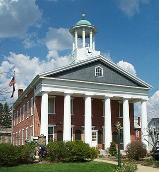
Fulton County is a county in the Commonwealth of Pennsylvania. As of the 2020 census, the population was 14,556, making it the fourth-least populous county in Pennsylvania. Its county seat is McConnellsburg. The county was created on April 19, 1850, from a part of Bedford County and named after inventor Robert Fulton. The county is part of the Southwest Pennsylvania region of the state.

<span class="mw-page-title-main">Cambria County, Pennsylvania</span> County in Pennsylvania, United States

Cambria County is a county in the Commonwealth of Pennsylvania. As of the 2020 census, the population was 133,472. Its county seat is Ebensburg. The county was created on March 26, 1804, from parts of Bedford, Huntingdon, and Somerset counties and later organized in 1807. It was named for the nation of Wales, which in Latin is known as "Cambria". The county is part of the Southwest Pennsylvania region of the state.

<span class="mw-page-title-main">Boswell, Pennsylvania</span> Borough in Pennsylvania, United States

Boswell is a borough in Somerset County, Pennsylvania, United States. It is part of the Johnstown, Pennsylvania Metropolitan Statistical Area. The population was 1,221 at the 2020 census.

<span class="mw-page-title-main">Lower Turkeyfoot Township, Pennsylvania</span> Township in Pennsylvania, United States

Lower Turkeyfoot Township is a township in Somerset County, Pennsylvania, United States. The population was 543 at the 2020 census. It is part of the Johnstown, Pennsylvania, Metropolitan Statistical Area.

<span class="mw-page-title-main">Middlecreek Township, Somerset County, Pennsylvania</span> Township in Pennsylvania, United States

Middlecreek Township is a township in Somerset County, Pennsylvania, United States. The population was 831 at the 2020 census. It is part of the Johnstown, Pennsylvania, Metropolitan Statistical Area.

<span class="mw-page-title-main">Milford Township, Somerset County, Pennsylvania</span> Township in Pennsylvania, United States

Milford Township is a township in Somerset County, Pennsylvania, United States. The population was 1,488 at the 2020 census. It is part of the Johnstown, Pennsylvania, Metropolitan Statistical Area.

<span class="mw-page-title-main">Quemahoning Township, Pennsylvania</span> Township in Pennsylvania, United States

Quemahoning Township is a township in Somerset County, Pennsylvania, United States. The population was 1,838 at the 2020 census. It is part of the Johnstown, Pennsylvania, Metropolitan Statistical Area.

<span class="mw-page-title-main">Rockwood, Pennsylvania</span> Borough in Pennsylvania, United States

Rockwood is a borough in Somerset County, Pennsylvania, United States. The population was 850 at the 2020 census. It is part of the Johnstown, Pennsylvania, Metropolitan Statistical Area, and located due north of Pennsylvania's highest peak, Mount Davis, which significantly constricts land travel routing south of the municipality.

<span class="mw-page-title-main">Shade Township, Pennsylvania</span> Township in Pennsylvania, United States

Shade Township is a township in Somerset County, Pennsylvania, United States. The population was 2,452 at the 2020 census. It is part of the Johnstown, Pennsylvania, Metropolitan Statistical Area.

<span class="mw-page-title-main">Shanksville, Pennsylvania</span> Borough in Pennsylvania, United States

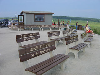
Shanksville is a borough in Somerset County, Pennsylvania, United States. It has a population of 197 as of the 2020 U.S. census. It is part of the Somerset, Pennsylvania Micropolitan Statistical Area and is located 78 miles (126 km) southeast of Pittsburgh and 226 miles (364 km) west of Philadelphia.

<span class="mw-page-title-main">Stonycreek Township, Somerset County, Pennsylvania</span> Township in Pennsylvania, United States

Stonycreek Township is a township in Somerset County, Pennsylvania, United States. The township takes its name from the stony creek, which flows through it and represents its western boundary. The stream takes its name from the rocky bed over which it flows for a great part of its course. Its Indian name was Sinne-Hanne or Achsin-Hanne. Hanne means a stream and especially a swift mountain stream. The population was 2,087 at the 2020 census. It is part of the Johnstown, Pennsylvania, metropolitan statistical area.

<span class="mw-page-title-main">Stoystown, Pennsylvania</span> Borough in Pennsylvania, United States

Stoystown is a borough in Somerset County, Pennsylvania, United States. It is part of the Johnstown, Pennsylvania, Metropolitan Statistical Area. The population was 300 at the 2020 census. Stoystown is located south-southeast of Johnstown and northeast of Somerset.

<span class="mw-page-title-main">Stonycreek River</span> River in the United States

The Stonycreek River is a tributary of the Conemaugh River, approximately 45 mi (72 km) long, in southwestern Pennsylvania in the United States.

The Quemahoning Reservoir, also known to locals as The Dam, is created by the Quemahoning Dam, located on Quemahoning Creek on the border of Quemahoning Township, Conemaugh Township, and Jenner Township in Somerset County, Pennsylvania just south of Hollsopple.

<span class="mw-page-title-main">Casselman River</span> Stream in Pennsylvania, USA

The Casselman River is a 56.5-mile-long (90.9 km) tributary of the Youghiogheny River in western Maryland and Pennsylvania in the United States. The Casselman River drains an area of 576 square miles.

<span class="mw-page-title-main">Pennsylvania Route 403</span> State highway in Pennsylvania, US

Pennsylvania Route 403 is a north–south state route in Somerset, Cambria and Indiana counties of Pennsylvania. The southern terminus is at U.S. Route 30 (US 30) in the hamlet of Kantner in Quemahoning Township. The northern terminus is at US 119 near Marion Center.

<span class="mw-page-title-main">Pennsylvania Route 281</span> State highway in Pennsylvania, US

Pennsylvania Route 281 is a 45.8-mile-long (73.7 km) state highway located in Fayette and Somerset counties in Pennsylvania. The southern terminus is the West Virginia state line near Markleysburg, where the road becomes West Virginia Route 26. The northern terminus is at U.S. Route 30 in Stoystown.

<span class="mw-page-title-main">Pennsylvania Route 653</span> State highway in Pennsylvania, US

Pennsylvania Route 653 (PA 653) is a 26-mile-long (42 km) state highway that is located in Fayette and Somerset counties in the Commonwealth of Pennsylvania in the United States.

<span class="mw-page-title-main">Pennsylvania House of Representatives, District 69</span> American legislative district

The 69th Pennsylvania House of Representatives District is located in southern Pennsylvania and has been represented by Carl Walker Metzgar since 2009.

<span class="mw-page-title-main">Shanksville-Stonycreek School District</span> School district in Pennsylvania

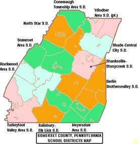
The Shanksville-Stonycreek School District is a public school district located in Somerset County, Pennsylvania. The school district serves the borough of Shanksville, Stonycreek Township, and the borough of Indian Lake. The district encompasses approximately 65 square miles (170 km2). According to 2000 U.S. data, it serves a resident population of 2,916.

References

  1. Includes Westmoreland, Cambria, Fayette, Blair, Indiana, Somerset, Bedford, Huntingdon, Greene and Fulton Counties
  1. "Census - Geography Profile: Somerset County, Pennsylvania". United States Census Bureau . Retrieved December 5, 2022.
  2. "Find a County". National Association of Counties. Retrieved June 7, 2011.
  3. 1 2 "Sources and detailed information", National Park Service website
  4. Espenshade, A. Howry (1925). Pennsylvania Place Names. State College, PA: Pennsylvania State College. p.  52.
  5. "State and County Maps of Pennsylvania". MapGeeks.org. Archived from the original on March 28, 2018. Retrieved October 23, 2016.
  6. "Washington and the French & Indian War". George Washington's Mount Vernon. Retrieved October 23, 2016.
  7. "Forbes Road Historical Marker". explorepahistory.com. Archived from the original on August 21, 2015.
  8. "History of Bedford and Somerset Counties, Chapter 4, Volume 2". www.pagenweb.org. Retrieved October 23, 2016.
  9. 9/11/01:The Today Show
  10. "2010 Census Gazetteer Files". United States Census Bureau. August 22, 2012. Retrieved March 10, 2015.
  11. "Why Does Garrett County Get So Much Snow? | Garrett County Weather". garrettcountyweather.com. Archived from the original on February 26, 2018. Retrieved February 26, 2018.
  12. "PRISM Climate Group at Oregon State University".
  13. "Geology, Map 13" (PDF). www.dcnr.state.pa.us. Archived from the original (PDF) on November 16, 2001. Retrieved November 29, 2018.
  14. "Geology, Map 59" (PDF). Pennsylvania Department of Conservation & Natural Resources. Archived from the original (PDF) on November 16, 2001. Retrieved November 29, 2018.
  15. "Geology, Map 11" (PDF). www.dcnr.state.pa.us. Archived from the original (PDF) on September 18, 2000. Retrieved November 29, 2018.
  16. [ permanent dead link ]
  17. "Geology, Map 10" (PDF). www.dcnr.state.pa.us. Archived from the original (PDF) on September 18, 2000. Retrieved November 29, 2018.
  18. "U.S. Decennial Census". United States Census Bureau. Retrieved March 10, 2015.
  19. "Historical Census Browser". University of Virginia Library. Retrieved March 10, 2015.
  20. Forstall, Richard L., ed. (March 24, 1995). "Population of Counties by Decennial Census: 1900 to 1990". United States Census Bureau. Retrieved March 10, 2015.
  21. "Census 2000 PHC-T-4. Ranking Tables for Counties: 1990 and 2000" (PDF). United States Census Bureau. April 2, 2001. Archived (PDF) from the original on October 9, 2022. Retrieved March 10, 2015.
  22. "State & County QuickFacts". United States Census Bureau. Archived from the original on August 11, 2011. Retrieved November 22, 2013.
  23. "Census 2020".
  24. "U.S. Census website". United States Census Bureau . Retrieved January 31, 2008.
  25. "P2 HISPANIC OR LATINO, AND NOT HISPANIC OR LATINO BY RACE – 2020: DEC Redistricting Data (PL 94-171) – Somerset County, Pennsylvania".
  26. "Office of Management and Budget | The White House". The White House. Retrieved November 29, 2018.
  27. 1 2 "Decennial Census by Decades". www.census.gov. Retrieved November 29, 2018.
  28. Leip, David. "Dave Leip's Atlas of U.S. Presidential Elections". uselectionatlas.org. Retrieved November 29, 2018.
  29. "Voter registration statistics by county". www.dos.pa.gov.
  30. 1 2 Center, Legislativate Data Processing. "Find Your Legislator". The official website for the Pennsylvania General Assembly. Retrieved September 6, 2019.
  31. "MILLER, Howard Shultz, (1879–1970)". Biographical Directory of the United States Congress. Retrieved October 14, 2012.
Community Festivals

39°58′N79°02′W / 39.97°N 79.03°W / 39.97; -79.03