Wyoming County, Pennsylvania

Last updated

Wyoming County
Wyoming co pa courthouse.png
The Wyoming County courthouse in Tunkhannock
Map of Pennsylvania highlighting Wyoming County.svg
Location within the U.S. state of Pennsylvania
Pennsylvania in United States.svg
Pennsylvania's location within the U.S.
Coordinates: 41°31′N76°01′W / 41.52°N 76.02°W / 41.52; -76.02
CountryFlag of the United States.svg United States
StateFlag of Pennsylvania.svg  Pennsylvania
FoundedApril 4, 1842
Named for Wyoming Valley
Seat Tunkhannock
Largest boroughTunkhannock
Area
  Total405 sq mi (1,050 km2)
  Land397 sq mi (1,030 km2)
  Water7.7 sq mi (20 km2)  1.9%
Population
 (2020)
  Total26,069
  Density66/sq mi (25/km2)
Time zone UTC−5 (Eastern)
  Summer (DST) UTC−4 (EDT)
Congressional district 12th
Website wyomingcountypa.gov

Wyoming County is a county in the Commonwealth of Pennsylvania. As of the 2020 census, the population was 26,069. [1] Its county seat is Tunkhannock. [2] It was created in 1842 from part of Luzerne County. The county is part of the Northeast Pennsylvania region of the state. [lower-alpha 1]

Contents

Wyoming County is included in the ScrantonWilkes-BarreHazleton, PA Metropolitan Statistical Area.

Geography

According to the U.S. Census Bureau, the county has a total area of 405 square miles (1,050 km2), of which 397 square miles (1,030 km2) is land and 7.7 square miles (20 km2) (1.9%) is water. [3] The county is intersected by the North Branch of the Susquehanna River, and drained by Tunkhannock, Mehoopany, and other large creeks. The land surface is generally hilly or mountainous, Mehoopany, Tunkhannock, Knob, and Bowman's mountains occupying a portion. The soil is fertile. Timber, coal, and iron are very abundant. [4]

Climate

The county has a humid continental climate which is warm-summer (Dfb) except along the river starting below Falls where it is hot-summer (Dfa). Average monthly temperatures in Tunkhannock range from 25.2 °F in January to 70.9 °F in July. [5]

Adjacent counties

Major roads

Demographics

Historical population
CensusPop.Note
1850 10,655
1860 12,54017.7%
1870 14,58516.3%
1880 15,5986.9%
1890 15,8911.9%
1900 17,1527.9%
1910 15,509−9.6%
1920 14,101−9.1%
1930 15,51710.0%
1940 16,7027.6%
1950 16,7660.4%
1960 16,8130.3%
1970 19,08213.5%
1980 26,43338.5%
1990 28,0766.2%
2000 28,0800.0%
2010 28,2760.7%
2020 26,069−7.8%
U.S. Decennial Census [6]
1790-1960 [7] 1900-1990 [8]
1990-2000 [9] 2010-2017 [10] 2010-2020 [11]

As of the census [12] of 2000, there were 28,080 people, 10,762 households, and 7,705 families residing in the county. The population density was 71 people per square mile (27 people/km2). There were 12,713 housing units at an average density of 32 per square mile (12/km2). The racial makeup of the county was 98.28% White, 0.53% Black or African American, 0.27% Asian, 0.17% Native American, 0.01% Pacific Islander, 0.15% from other races, and 0.59% from two or more races. 0.67% of the population were Hispanic or Latino of any race. 20.3% were of German, 12.9% Irish, 11.9% English, 11.6% Polish, 9.6% American and 8.1% Italian ancestry.

There were 10,762 households, out of which 33.20% had children under the age of 18 living with them, 58.10% were married couples living together, 9.30% had a female householder with no husband present, and 28.40% were non-families. 24.10% of all households were made up of individuals, and 9.90% had someone living alone who was 65 years of age or older. The average household size was 2.55 and the average family size was 3.02. In the county, the population was spread out, with 25.50% under the age of 18, 8.00% from 18 to 24, 28.10% from 25 to 44, 25.20% from 45 to 64, and 13.20% who were 65 years of age or older. The median age was 38 years. For every 100 females there were 98.60 males. For every 100 females age 18 and over, there were 95.80 males.

2020 census

Wyoming County Racial Composition [13]
RaceNum.Perc.
White (NH)24,14292.6%
Black or African American (NH)2140.82%
Native American (NH)320.12%
Asian (NH)1150.44%
Pacific Islander (NH)30.01%
Other/Mixed (NH)9823.76%
Hispanic or Latino 5812.22%

Politics

United States presidential election results for Wyoming County, Pennsylvania [14] [15]
Year Republican Democratic Third party
No.%No.%No.%
2020 9,93666.68%4,70431.57%2601.74%
2016 8,83766.63%3,81128.74%6144.63%
2012 6,58755.26%5,06142.45%2732.29%
2008 6,98352.81%5,98545.26%2551.93%
2004 7,78260.65%4,98238.82%680.53%
2000 6,92259.12%4,36337.26%4243.62%
1996 4,88846.96%4,04938.90%1,47114.13%
1992 5,14347.40%3,15829.11%2,54923.49%
1988 6,60769.94%2,79729.61%430.46%
1984 7,23074.01%2,51825.78%210.21%
1980 5,91964.57%2,76630.17%4825.26%
1976 5,70560.34%3,62838.37%1221.29%
1972 6,42374.42%2,11224.47%961.11%
1968 5,20764.09%2,36629.12%5516.78%
1964 3,86447.45%4,26852.41%120.15%
1960 6,18869.36%2,72630.56%70.08%
1956 5,90673.56%2,12026.40%30.04%
1952 5,77275.72%1,81523.81%360.47%
1948 4,33270.70%1,67427.32%1211.97%
1944 4,58169.60%1,98230.11%190.29%
1940 5,27367.14%2,54832.44%330.42%
1936 5,32161.25%3,26937.63%971.12%
1932 3,96858.00%2,72839.88%1452.12%
1928 5,32185.00%90614.47%330.53%
1924 3,21368.06%1,19425.29%3146.65%
1920 3,20868.43%1,24726.60%2334.97%
1916 1,69852.12%1,44444.32%1163.56%
1912 48013.59%1,50542.60%1,54843.82%
1908 2,23455.79%1,62940.68%1413.52%
1904 2,30856.90%1,57538.83%1734.27%
1900 2,24752.61%1,87543.90%1493.49%
1896 2,37353.24%1,95143.77%1332.98%
1892 2,02949.82%1,90546.77%1393.41%
1888 2,02650.70%1,84146.07%1293.23%

As of May 15, 2023, there were 17,361 registered voters in Wyoming County. [16]

Chart of Voter Registration

   Republican (60.83%)
   Democratic (27.69%)
   Independent (7.51%)
   Other Parties (3.97%)

County commissioners

  • Richard Wilbur, Chair, Republican
  • Thomas Henry, Vice-chair, Republican
  • Ernest King, Democrat

Other county offices

  • Auditors:
    • Laura Dickson, Democrat
    • Ashley Ritz Darby, Republican
    • Judy Shupp, Republican
  • District Attorney, Jeff Mitchell, Democrat
  • Prothonotary, Cindy Adams, Republican
  • Register of Wills & Recorder of Deeds, Dennis Montross, Republican
  • Sheriff, Robert Roberts, Republican
  • Treasurer, Patricia Mead, Republican

State representative

State senator

United States House of Representatives

United States Senator

Education

Map of Wyoming County, Pennsylvania School Districts Map of Wyoming County Pennsylvania School Districts.png
Map of Wyoming County, Pennsylvania School Districts

Public school districts

Higher education

Transportation

Skyhaven Airport is a public use airport located in Wyoming County, one nautical mile (1.85 km) south of the central business district of Tunkhannock. [17]

With the town sited on the lower end of the upper third of the Susquehanna, busily wending its way south to the Chesapeake Bay, the river banks to either side the whole length of the Susquehanna were historically used as a rail transport corridor with competing railroads typically making their way on either side on the important NYC and Philadelphia to Buffalo, New York routes connecting the eastern seaboard to cities such as Chicago on the Great Lakes; towns like Tunkhannock played an important role in the highly competitive stakes for such high profit passenger expresses for steam locomotives had surprisingly short cruising ranges and passenger travel had higher earnings than freight. Today, except for select parts, the river bank rail transport infrastructures remaining are mainly left bank located assets of a single railroad's operations department, even shared roads (operated over by several lines) these days use the single corridor along the east/left river bank connecting the large Sayre Yard on the stateline in Sayre, Pennsylvania further upriver to the transitional Duryea yard. After the collapse of Conrail, trackage on the Northern Susquehanna is operated by Norfolk Southern, with some areas sublet to other road companies. The trackage running through Tunkhannock

Pennsylvania Route 29, a continuation of PA-309 from Philadelphia and Allentown, connects to the New York state line providing north–south road connections by secondary highway while PA-92, and especially U.S. Route 6, provide major east–west secondary highway access to the region.

Communities

Map of Wyoming County, Pennsylvania with Municipal Labels showing Boroughs (red) and Townships (white). Map of Wyoming County Pennsylvania With Municipal and Township Labels.png
Map of Wyoming County, Pennsylvania with Municipal Labels showing Boroughs (red) and Townships (white).

Under Pennsylvania law, there are four types of incorporated municipalities: cities, boroughs, townships, and, in at most two cases, towns. The following boroughs and townships are located in Wyoming County:

Boroughs

Townships

Census-designated places

Unincorporated communities

Ghost towns

Population ranking

The population ranking of the following table is based on the 2010 census of Wyoming County. [18]

county seat

RankCity/Town/etc.Municipal typePopulation (2010 Census)
1 Tunkhannock Borough1,836
2 Factoryville Borough1,158
3 Nicholson Borough767
4 Lake Winola CDP748
5 Noxen CDP633
6 Meshoppen Borough563
7 West Falls CDP382
8 Laceyville Borough379

See also

Related Research Articles

<span class="mw-page-title-main">Wayne County, Pennsylvania</span> County in Pennsylvania

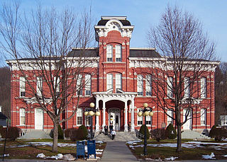
Wayne is a county in the Commonwealth of Pennsylvania. The county's population was 51,155 at the 2020 census. The county seat is the Borough of Honesdale. The county was formed from part of Northampton County on March 21, 1798, and was named for the Revolutionary War General Anthony Wayne. The county is part of the Northeast Pennsylvania region of the state.

<span class="mw-page-title-main">Susquehanna County, Pennsylvania</span> County in Pennsylvania, United States

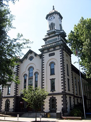
Susquehanna County is a county in the Commonwealth of Pennsylvania. As of the 2020 census, the population was 38,434 Its county seat is Montrose. The county was created on February 21, 1810, from part of Luzerne County and later organized in 1812. It is named for the Susquehanna River. The county is part of the Northeast Pennsylvania region of the state.

<span class="mw-page-title-main">Sullivan County, Pennsylvania</span> County in Pennsylvania, United States

Sullivan County is a county in the Commonwealth of Pennsylvania. As of the 2020 census, the population was 5,840, making it the second-least populous county in Pennsylvania. Its county seat is Laporte. The county was created on March 15, 1847, from part of Lycoming County and named for Major General John Sullivan. The county is part of the Northeast Pennsylvania region of the state.

<span class="mw-page-title-main">Northumberland County, Pennsylvania</span> County in Pennsylvania, United States

Northumberland County is a county in the Commonwealth of Pennsylvania. As of the 2020 census, the population was 91,647. Its county seat is Sunbury. The county is part of the Central Pennsylvania region of the state.

<span class="mw-page-title-main">Montour County, Pennsylvania</span> County in Pennsylvania, United States

Montour County is a county in the Commonwealth of Pennsylvania. As of the 2020 census, the population was 18,136. Its county seat is Danville. The county is named for Andrew Montour, a prominent Métis interpreter who served with George Washington during the French and Indian War. It encompasses 132 sq mi, making it the smallest county by land area in the state. The county is part of the Central Pennsylvania region of the state.

<span class="mw-page-title-main">Luzerne County, Pennsylvania</span> County in Pennsylvania, United States

Luzerne County is a county in the Commonwealth of Pennsylvania. According to the United States Census Bureau, the county has a total area of 906 square miles (2,350 km2), of which 890 square miles (2,300 km2) is land and 16 square miles (41 km2) is water. It is Northeastern Pennsylvania's second-largest county by total area. As of the 2020 census, the population was 325,594, making it the most populous county in the northeastern part of the state. The county seat and most populous city is Wilkes-Barre. Other populous communities include Hazleton, Kingston, Nanticoke, and Pittston. Luzerne County is included in the Scranton–Wilkes-Barre–Hazleton Metropolitan Statistical Area, which has a total population of 555,426 as of 2017. The county is part of the Northeast Pennsylvania region of the state.

<span class="mw-page-title-main">Lackawanna County, Pennsylvania</span> County in Pennsylvania, United States

Lackawanna County is a county in the Commonwealth of Pennsylvania. It is located in Northeastern Pennsylvania and had a population of 215,615 (2022). Its county seat and most populous city is Scranton. The county is part of the Northeast Pennsylvania region of the state.

<span class="mw-page-title-main">Carbon County, Pennsylvania</span> County in Pennsylvania, United States

Carbon County is a county in the Commonwealth of Pennsylvania. As of the 2020 census, the population was 64,749. The county is part of the Northeast Pennsylvania region of the state.

<span class="mw-page-title-main">Bradford County, Pennsylvania</span> County in Pennsylvania, United States

Bradford County is a county in the Commonwealth of Pennsylvania. As of the 2020 census, its population was 59,967. Its county seat is Towanda. The county was created on February 21, 1810, from parts of Lycoming and Luzerne Counties. Originally called Ontario County, it was reorganized and separated from Lycoming County on October 13, 1812, and renamed Bradford County for William Bradford, who had been a chief justice of the Pennsylvania Supreme Court and United States Attorney General. The county is part of the Northeast Pennsylvania region of the state.

<span class="mw-page-title-main">Huntington Township, Luzerne County, Pennsylvania</span> Township in Pennsylvania, United States

Huntington Township is an American township which is in Luzerne County, Pennsylvania. The population was 2,052 at the time of the 2020 census.

<span class="mw-page-title-main">Pittston Township, Pennsylvania</span> Township in Pennsylvania, United States

Pittston Township is a township in Luzerne County, Pennsylvania. The population was 3,179 as of the 2020 census. The township is located within the Greater Pittston region. As of 2010, the total population of Greater Pittston was 48,020. The Wilkes-Barre/Scranton International Airport is located in Pittston Township.

<span class="mw-page-title-main">White Haven, Pennsylvania</span> Borough in Pennsylvania, United States

White Haven is a borough in Luzerne County, Pennsylvania, United States. It is located along the Lehigh River. The population was 1,163 at the 2020 census.

<span class="mw-page-title-main">Nicholson, Pennsylvania</span> Borough in Pennsylvania, United States

Nicholson is a borough in Wyoming County, Pennsylvania. The population was 698 at the 2020 census.

<span class="mw-page-title-main">Bowman Creek</span> River

Bowman Creek is a tributary of the Susquehanna River in Luzerne County and Wyoming County, in Pennsylvania, in the United States. It is approximately 26 miles (42 km) long and flows through Ross Township and Lake Township in Luzerne County and Noxen Township, Monroe Township, and Eaton Township in Wyoming County. The watershed of the creek has an area of 120 square miles (310 km2). The creek is not designated as an impaired waterbody and its pH is close to neutral, although it has experienced some problems with acid rain. It has low concentrations of dissolved solids like calcium. The creek is relatively small in its upper reaches, but by Noxen, its width is 40 to 60 feet. It is also relatively shallow in many reaches. Rock formations in the watershed include the Catskill Formation, the Huntley Mountain Formation, Burgoon Sandstone, the Mauch Chunk Formation, the Pottsville Group, and the Pocono Formation. Soil associations in the creek's watershed include the Wellsboro-Morris-Oquaga association, the Oquaga-Lackawanna-Arnot association, the Mardin-Bath-Volusia association, and the Wyoming-Pope association.

<span class="mw-page-title-main">Mehoopany Creek</span>

Mehoopany Creek is a tributary of the Susquehanna River in Sullivan and Wyoming counties, Pennsylvania, in the United States. It is approximately 26.8 miles (43.1 km) long. In Sullivan County the creek flows through Colley Township and in Wyoming County it flows through Forkston Township and Mehoopany Township. The stream's watershed has an area of 123 square miles (320 km2). Its major tributaries include Stony Brook and North Fork Mehoopany Creek.

<span class="mw-page-title-main">Sugar Hollow Creek</span> River

Sugar Hollow Creek is a tributary of Bowman Creek in Wyoming County, Pennsylvania, in the United States. It is approximately 4.7 miles (7.6 km) long and flows through Mehoopany Township and Eaton Township. The watershed of the creek has an area of 7.07 square miles (18.3 km2). The creek is not designated as an impaired waterbody. The surficial geology near its mouth consists of alluvium, Wisconsinan Outwash, and Wisconsinan Till. The creek is a High-Quality Coldwater Fishery, a Migratory Fishery, and Class A Wild Trout Waters.

<span class="mw-page-title-main">Roaring Run (Bowman Creek tributary)</span> River

Roaring Run is a tributary of Bowman Creek in Wyoming County, Pennsylvania, in the United States. It is approximately 4.9 miles (7.9 km) long and flows through Forkston Township, Noxen Township, and Monroe Township. It has two named tributaries: Newton Run and South Branch Roaring Run. The watershed of Roaring Run has an area of 11.4 square miles (30 km2). It is designated as a High-Quality Coldwater Fishery and a Migratory Fishery and the stream is Class A Wild Trout Waters. The surficial geology in its vicinity consists of alluvium, alluvial terrace, alluvial fan, bedrock, Wisconsinan Till, and Wisconsinan Ice-Contact Stratified Drift. A bridge carrying Pennsylvania Route 29 crosses the stream.

<span class="mw-page-title-main">Cider Run (Bowman Creek tributary)</span> River in Pennsylvania, U.S.

Cider Run is a tributary of Bowman Creek in Wyoming County, Pennsylvania, in the United States. It is approximately 2.5 miles (4.0 km) long and flows through Forkston Township and Noxen Township. The watershed of the stream has an area of 3.77 square miles (9.8 km2). The stream is not designated as an impaired waterbody. Its watershed is classified as Exceptional Value waters and a Migratory Fishery and the stream is designated as a Wilderness Trout Stream.

North Branch Mehoopany Creek is a tributary of Mehoopany Creek in Bradford County, Sullivan County, and Wyoming County, in Pennsylvania, in the United States. It is approximately 14 miles (23 km) long and flows through Wilmot Township in Bradford County, Colley Township in Sullivan County, and North Branch Township and Forkston Township. The watershed of the creek has an area of 40.0 square miles (104 km2). The creek has eight named direct tributaries, including hollows. In the 1940s and 1950s, the average discharge for September was found to be just 6.8 cubic feet per second (0.19 m3/s), but was found to be over 100 cubic feet per second (2.8 m3/s) for July and August.

Kasson Brook is a tributary of Mehoopany Creek in Wyoming County, Pennsylvania, in the United States. It is approximately 2.7 miles (4.3 km) long and flows through Forkston Township. The watershed of the stream has an area of 4.53 square miles (11.7 km2). The stream is not designated as an impaired waterbody and is classified as a High-Quality Coldwater Fishery. It is one of several streams to cut through South Mountain.

References

  1. Includes Luzerne, Lackawanna, Monroe, Schuylkill, Carbon, Pike, Bradford, Wayne, Susquehanna, Wyoming and Sullivan Counties
  1. "Census - Geography Profile: Wyoming County, Pennsylvania". United States Census Bureau . Retrieved December 18, 2022.
  2. "Find a County". National Association of Counties. Archived from the original on May 31, 2011. Retrieved June 7, 2011.
  3. "2010 Census Gazetteer Files". United States Census Bureau. August 22, 2012. Retrieved March 11, 2015.
  4. Ripley, George; Dana, Charles A., eds. (1879). "Wyoming. II. A N. E. county of Pennsylvania"  . The American Cyclopædia .
  5. "PRISM Climate Group at Oregon State University".
  6. "U.S. Decennial Census". United States Census Bureau. Retrieved March 11, 2015.
  7. "Historical Census Browser". University of Virginia Library. Archived from the original on August 11, 2012. Retrieved March 11, 2015.
  8. Forstall, Richard L., ed. (March 24, 1995). "Population of Counties by Decennial Census: 1900 to 1990". United States Census Bureau. Archived from the original on March 20, 2015. Retrieved March 11, 2015.
  9. "Census 2000 PHC-T-4. Ranking Tables for Counties: 1990 and 2000" (PDF). United States Census Bureau. April 2, 2001. Archived (PDF) from the original on December 18, 2014. Retrieved March 11, 2015.
  10. "State & County QuickFacts". United States Census Bureau. Archived from the original on June 6, 2011. Retrieved November 22, 2013.
  11. "census 2020".
  12. "U.S. Census website". United States Census Bureau . Retrieved May 14, 2011.
  13. "P2 HISPANIC OR LATINO, AND NOT HISPANIC OR LATINO BY RACE – 2020: DEC Redistricting Data (PL 94-171) – Wyoming County, Pennsylvania".
  14. Leip, David. "Dave Leip's Atlas of U.S. Presidential Elections". uselectionatlas.org. Archived from the original on March 23, 2018. Retrieved May 6, 2018.
  15. The leading "other" candidate, Progressive Theodore Roosevelt, received 1,464 votes, while Prohibition candidate Eugene Chafin received 51 votes, and Socialist Labor candidate Arthur Reimer received 33 votes.
  16. Pennsylvania Department of State (May 15, 2023). "Voter registration statistics by county". dos.pa.gov. Retrieved May 17, 2023.
  17. FAA Airport Form 5010 for 76N PDF . Federal Aviation Administration. Effective February 11, 2010.
  18. "2010 U.S. Census website". United States Census Bureau . Retrieved February 10, 2013.

41°31′N76°01′W / 41.52°N 76.02°W / 41.52; -76.02