
Sullivan County is a county in the Commonwealth of Pennsylvania. It is part of Northeastern Pennsylvania. As of the 2020 census, the population was 5,840, making it the second-least populous county in Pennsylvania. Its county seat is Laporte. The county was created on March 15, 1847, from part of Lycoming County and named for Major General John Sullivan.

Plunketts Creek Township is a township in Lycoming County, Pennsylvania, United States. It includes the villages of Barbours and Proctor. The population was 595 at the 2020 census, down from 684 at the 2010 census. It is part of the Williamsport Metropolitan Statistical Area.

Ricketts Glen State Park is a Pennsylvania state park on 13,193 acres (5,280 ha) in Columbia, Luzerne, and Sullivan counties in Pennsylvania in the United States. Ricketts Glen is a National Natural Landmark known for its old-growth forest and 24 named waterfalls along Kitchen Creek, which flows down the Allegheny Front escarpment from the Allegheny Plateau to the Ridge-and-Valley Appalachians. The park is near the borough of Benton on Pennsylvania Route 118 and Pennsylvania Route 487, and is in five townships: Sugarloaf in Columbia County, Fairmount and Ross in Luzerne County, and Colley and Davidson in Sullivan County.

Orson is a village in Preston Township, Pennsylvania, United States, situated in the Lake Region of the Poconos. It was once an important depot of the Scranton Division of the New York, Ontario & Western (O&W) Railway, but today, when it is known outside of its immediate vicinity, it is largely for being the site of the intersection of two state roads, Belmont Turnpike and Crosstown Highway, or as the location of Independent Lake Camp (ILC), since ILC's reputation and commercial reach, like those of most rural American summer camps, extend beyond the community in which the camp is physically located.

Bowman Creek is a tributary of the Susquehanna River in Luzerne County and Wyoming County, in Pennsylvania, in the United States. It is approximately 26 miles (42 km) long and flows through Ross Township and Lake Township in Luzerne County and Noxen Township, Monroe Township, and Eaton Township in Wyoming County. The watershed of the creek has an area of 120 square miles (310 km2). The creek is not designated as an impaired waterbody and its pH is close to neutral, although it has experienced some problems with acid rain. It has low concentrations of dissolved solids like calcium. The creek is relatively small in its upper reaches, but by Noxen, its width is 40 to 60 feet. It is also relatively shallow in many reaches. Rock formations in the watershed include the Catskill Formation, the Huntley Mountain Formation, Burgoon Sandstone, the Mauch Chunk Formation, the Pottsville Group, and the Pocono Formation. Soil associations in the creek's watershed include the Wellsboro-Morris-Oquaga association, the Oquaga-Lackawanna-Arnot association, the Mardin-Bath-Volusia association, and the Wyoming-Pope association.

Stull is an unincorporated community in Douglas County, Kansas, United States. Founded in 1857, the settlement was initially known as Deer Creek until it was renamed after its only postmaster, Sylvester Stull. As of 2018, only a handful of structures remain in the area.

There are 24 named waterfalls in Ricketts Glen State Park in the U.S. state of Pennsylvania along Kitchen Creek as it flows in three steep, narrow valleys, or glens. They range in height from 9 feet (2.7 m) to the 94-foot (29 m) Ganoga Falls. Ricketts Glen State Park is named for R. Bruce Ricketts, a colonel in the American Civil War who owned over 80,000 acres in the area in the late 19th and early 20th centuries, but spared the old-growth forests in the glens from clearcutting. The park, which opened in 1944, is administered by the Bureau of State Parks of the Pennsylvania Department of Conservation and Natural Resources (DCNR). Nearly all of the waterfalls are visible from the Falls Trail, which Ricketts had built from 1889 to 1893 and which the state park rebuilt in the 1940s and late 1990s. The Falls Trail has been called "the most magnificent hike in the state" and one of "the top hikes in the East".
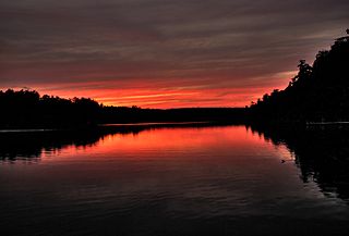
Ganoga Lake is a natural lake in Colley Township in southeastern Sullivan County in Pennsylvania, United States. Known as Robinson's Lake and Long Pond for most of the 19th century, the lake was purchased by the Ricketts family in the early 1850s and became part of R. Bruce Ricketts' extensive holdings in the area after the American Civil War. The lake is one of the highest in Pennsylvania, which led Ricketts to name it Highland Lake by 1874 and rename it Ganoga Lake in 1881; Pennsylvania senator Charles R. Buckalew suggested the name Ganoga from the Seneca language word for "water on the mountain".

The Clemuel Ricketts Mansion is a Georgian-style house made of sandstone, built in 1852 or 1855 on the shore of Ganoga Lake in Colley Township, Sullivan County, Pennsylvania in the United States. It was home to several generations of the Ricketts family, including R. Bruce Ricketts and William Reynolds Ricketts. Originally built as a hunting lodge, it was also a tavern and post office, and served as part of a hotel for much of the 19th century.
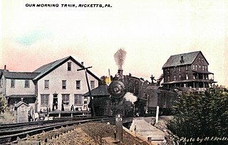
Ricketts is a ghost town that was established as a lumber mill company town in Sullivan and Wyoming counties, in the U.S. state of Pennsylvania. Ricketts was built in 1890 along Mehoopany Creek in both Colley Township in Sullivan County and Forkston Township in Wyoming County for sawmills of the Trexler and Turrell Lumber Company. It was named for Robert Bruce Ricketts, who owned most of the land and timber around the village, and who was a partner in the company with Harry Clay Trexler, J.H. Turrell, and others. Ricketts had 800 inhabitants at its peak and extended into the northernmost section of what is now Ricketts Glen State Park. Rail lines were built to the mills at Ricketts, including the Bowman Creek branch of the Lehigh Valley Railroad which opened in 1893. The mills closed in 1913 when the lumber was exhausted and the last house was torn down in the 1930s.
Kickapoo Center is an unincorporated community located in the town of Kickapoo, Vernon County, Wisconsin, United States. Kickapoo Center is located on Wisconsin Highway 131 near the Kickapoo River, 3 miles (4.8 km) south-southwest of Viola.
Noxen is a census-designated place that is located in Noxen Township, Wyoming County in the Commonwealth of Pennsylvania in the United States.

Roaring Run is a tributary of Bowman Creek in Wyoming County, Pennsylvania, in the United States. It is approximately 4.9 miles (7.9 km) long and flows through Forkston Township, Noxen Township, and Monroe Township. It has two named tributaries: Newton Run and South Branch Roaring Run. The watershed of Roaring Run has an area of 11.4 square miles (30 km2). It is designated as a High-Quality Coldwater Fishery and a Migratory Fishery and the stream is Class A Wild Trout Waters. The surficial geology in its vicinity consists of alluvium, alluvial terrace, alluvial fan, bedrock, Wisconsinan Till, and Wisconsinan Ice-Contact Stratified Drift. A bridge carrying Pennsylvania Route 29 crosses the stream.
South Branch Roaring Run is a tributary of Roaring Run in Wyoming County, Pennsylvania, in the United States. It is approximately 2.0 miles (3.2 km) long and flows through Noxen Township and Forkston Township. The watershed of the stream has an area of 3.31 square miles (8.6 km2). The surficial geology in its vicinity consists of bedrock, Wisconsinan Till, Wisconsinan Bouldery Till, Wisconsinan Ice-Contact Stratified Drift, and alluvium. South Branch Roaring Run is classified as Class A Wild Trout Waters.

Hettesheimer Run is a tributary of Bowman Creek in Wyoming County, Pennsylvania, in the United States. It is approximately 1.6 miles (2.6 km) long and flows through Noxen Township. The watershed of the stream has an area of 1.94 square miles (5.0 km2). It is not designated as an impaired waterbody. The stream was historically used as an industrial water supply. Its watershed is designated as a High-Quality Coldwater Fishery and a Migratory Fishery and the stream is Class A Wild Trout Waters.

Stone Run is a tributary of Bowman Creek in Wyoming County, Pennsylvania, in the United States. It is approximately 2.2 miles (3.5 km) long and flows through Noxen Township. The watershed of the stream has an area of 2.43 square miles (6.3 km2). The stream is not designated as an impaired waterbody. The surficial geology in its vicinity consists of alluvium, Wisconsinan Ice-Contact Stratified Drift, Wisconsinan Till, and Wisconsinan Bouldery Till. The stream is classified as Class A Wild Trout Waters and its watershed is designated as a High-Quality Coldwater Fishery and a Migratory Fishery.

Sorber Run is a tributary of Bowman Creek in Luzerne County and Wyoming County, in Pennsylvania, in the United States. It is approximately 3.1 miles (5.0 km) long and flows through Lake Township in Luzerne County and Noxen Township in Wyoming County. The watershed of the stream has an area of 2.08 square miles (5.4 km2). The surficial geology in the stream's vicinity consists of alluvium and Wisconsinan Till. The watershed is designated as Exceptional Value waters and a Migratory Fishery. The stream is one of two Wilderness Trout Streams in Wyoming County.
Windfall Run is a tributary of Baker Run in Wyoming County, Pennsylvania, in the United States. It is approximately 1.6 miles (2.6 km) long and flows through Noxen Township. The watershed of the stream has an area of 1.68 square miles (4.4 km2). The stream itself is classified as Class A Wild Trout Waters by the Pennsylvania Fish and Boat Commission. The surficial geology in its vicinity includes Wisconsinan Till and bedrock.
Broad Hollow Run is a tributary of Bowman Creek in Wyoming County, Pennsylvania, in the United States. It is approximately 1.0 mile (1.6 km) long and flows through Noxen Township. The watershed of the stream has an area of 1.04 square miles (2.7 km2). The surficial geology in the vicinity of the stream consists of alluvium, alluvial fan, and Wisconsinan Till. Its watershed is designated as a High-Quality Coldwater Fishery and a Migratory Fishery.
Sugar Run is a tributary of Bowman Creek in Luzerne County and Wyoming County, in Pennsylvania, in the United States. It is approximately 1.8 miles (2.9 km) long and flows through Lake Township in Luzerne County and Noxen Township in Wyoming County. The watershed of the stream has an area of 1.02 square miles (2.6 km2). The surficial geology in its vicinity consists of alluvium, alluvial fan, Wisconsinan Till, and bedrock. The stream's watershed is designated as a High-Quality Coldwater Fishery and a Migratory Fishery.

