Laurel Highlands

Last updated

Autumn on a small road in Somerset County LaurelMTS2.jpg
Autumn on a small road in Somerset County

The Laurel Highlands is a region in southwestern Pennsylvania made up of Fayette County, Somerset County, and Westmoreland County. [1] It has a population of about 600,000 people.

Contents

The region is approximately fifty-five miles southeast of Pittsburgh; the Laurel Highlands center on Laurel Hill and Chestnut Ridge of the Allegheny Mountains. The mountains making up the Laurel Highlands are the highest in Pennsylvania, with Mount Davis in Somerset County the highest point in the state at 3,213 feet (979 m). Because of the elevation, weather in the Laurel Highlands is generally cooler and wetter than in most other parts of the state.

The Laurel Highlands is a popular area for camping, hiking, mountain biking, hunting, whitewater kayaking, trout fishing, wildlife viewing, downhill (and cross-country) skiing, and golf.

Amusement parks and resorts

Seven Springs Mountain Resort in Seven Springs during Fourth of July celebrations Seven Springs Resort on 4th of July at dusk viewed from the summit pre fireworks.jpg
Seven Springs Mountain Resort in Seven Springs during Fourth of July celebrations

Architecture

National parks and historic sites

Flight 93 National Memorial in Stonycreek Township Flight 93 Memorial flight path.jpg
Flight 93 National Memorial in Stonycreek Township
Fallingwater, designed by American architect Frank Lloyd Wright, in Springfield Township Fallingwater, Pennsylvania.jpg
Fallingwater, designed by American architect Frank Lloyd Wright, in Springfield Township

National Parks

UNESCO World Heritage Site

Historic Sites

Fort Ligonier in Ligonier Fort Ligonier1.jpg
Fort Ligonier in Ligonier

Parks and outdoor recreation

State Parks and Forests

Trails

Downhill ski areas

Related Research Articles

<span class="mw-page-title-main">Somerset County, Pennsylvania</span> County in Pennsylvania, United States

Somerset County is a county in the Commonwealth of Pennsylvania. As of the 2020 census, the population was 74,129. Its county seat is Somerset. The county was created from part of Bedford County on April 17, 1795, and named after the county of Somerset in England.

<span class="mw-page-title-main">Cambria County, Pennsylvania</span> County in Pennsylvania, United States

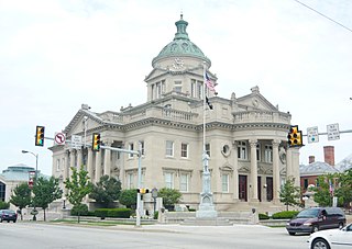
Cambria County is a county in the Commonwealth of Pennsylvania. As of the 2020 census, the population was 133,472. Its county seat is Ebensburg. The county was created on March 26, 1804, from parts of Bedford, Huntingdon, and Somerset counties and later organized in 1807. It was named for the nation of Wales, which in Latin is known as "Cambria".

<span class="mw-page-title-main">Smithton, Pennsylvania</span> Borough in Pennsylvania, United States

Smithton is a borough in Westmoreland County, Pennsylvania, United States. The population was 399 at the 2010 census. As of 2018, the population was listed at 378. Smithton has its own post office, with zip code 15479, and is serviced by Yough School District.

The Potomac Heritage Trail, also known as the Potomac Heritage National Scenic Trail or the PHT, is a designated National Scenic Trail corridor spanning parts of the mid-Atlantic region of the United States that will connect various trails and historic sites in Virginia, Maryland, Pennsylvania, and the District of Columbia. The trail network includes 710 miles (1,140 km) of existing and planned sections, tracing the natural, historical, and cultural features of the Potomac River corridor, the upper Ohio River watershed in Pennsylvania and western Maryland, and a portion of the Rappahannock River watershed in Virginia. The trail is managed by the National Park Service and is one of three National Trails that are official NPS units.

<span class="mw-page-title-main">Blue Knob State Park</span>

Blue Knob State Park is a 6,128-acre (2,480 ha) Pennsylvania state park in Kimmel, Lincoln, and Pavia townships in Bedford County, Pennsylvania, in the United States. The average annual snowfall at the park is about 12 feet (370 cm). The park is named for Blue Knob, the second highest mountain in Pennsylvania at 3,146 feet (959 m). It is the location of Blue Knob All Seasons Resort, the ski slope in Pennsylvania with the highest elevation. Blue Knob State Park is just off Interstate 99 on Pennsylvania Route 869 west of Pavia.

<span class="mw-page-title-main">Forbes State Forest</span> State forest in Pennsylvania, United States

Forbes State Forest is a Pennsylvania state forest in Pennsylvania Bureau of Forestry District #4. The main offices are located in Laughlintown in Westmoreland County, Pennsylvania in the United States. Mount Davis, the highest peak in Pennsylvania, is located in the forest.

<span class="mw-page-title-main">Gallitzin State Forest</span> State forest in Pennsylvania, United States

Gallitzin State Forest is a Pennsylvania State Forest in Pennsylvania Bureau of Forestry District #6. The main offices are located in Ebensburg in Cambria County, Pennsylvania in the United States.

<span class="mw-page-title-main">Ohiopyle State Park</span>

Ohiopyle State Park is a Pennsylvania state park on 20,500 acres (8,300 ha) in Dunbar, Henry Clay and Stewart Townships, Fayette County, Pennsylvania in the United States. The focal point of the park is the more than 14 miles (23 km) of the Youghiogheny River Gorge that passes through the park. The river provides some of the best whitewater boating in the Eastern United States. Ohiopyle State Park is bisected by Pennsylvania Route 381 south of the Pennsylvania Turnpike. The park opened to the public in 1965 but was not officially dedicated until 1971.

<span class="mw-page-title-main">Keystone State Park (Pennsylvania)</span> State park in Westmoreland County, Pennsylvania, United States

Keystone State Park is a 1,200-acre (486 ha) Pennsylvania state park in Derry Township, Westmoreland County, Pennsylvania in the United States. Located off U.S. Route 22 near New Alexandria, the park opened in 1945. Its main attraction is the man-made 78-acre (32 ha) Keystone Lake. The park also has extensive picnic areas and several miles of hiking trails.

<span class="mw-page-title-main">Yellow Creek State Park</span> State park in Indiana County, Pennsylvania

Yellow Creek State Park is a Pennsylvania state park on 2,981 acres (1,206 ha) in Brush Valley and Cherryhill Townships, Indiana County, Pennsylvania in the United States. The park encompasses parts of Yellow Creek and Little Yellow Creek. The old Kittanning Path goes through the parkland. The park was established in 1963. An additional 159 acres (64 ha) of developed land were purchased in 1982. Yellow Creek Lake, a 720-acre (290 ha) man-made lake, was built in 1969 by an earth and rock dam on Yellow Creek. Yellow Creek State Park is between the boroughs of Ebensburg and Indiana on U.S. Route 422.

<span class="mw-page-title-main">Kooser State Park</span>

Kooser State Park is a 250-acre (101 ha) Pennsylvania state park in Jefferson Township, Somerset County, Pennsylvania, in the United States. The park, which borders Forbes State Forest, was built in the 1930s by the Civilian Conservation Corps, who also built the 4-acre (1.6 ha) Kooser Lake by damming Kooser Run. Kooser State Park is on Pennsylvania Route 31 a one-hour drive from Pittsburgh. The park is surrounded by Forbes State Forest.

<span class="mw-page-title-main">Laurel Mountain State Park</span>

Laurel Mountain State Park is a 493-acre (200 ha) Pennsylvania state park in Ligonier Township, Westmoreland County and Jenner Township, Somerset County, Pennsylvania in the United States.

<span class="mw-page-title-main">Laurel Hill State Park</span>

Laurel Hill State Park is a 3,935-acre (1,592 ha) Pennsylvania state park in Jefferson and Middlecreek Townships, Somerset County, Pennsylvania in the United States. Laurel Hill Lake is a 63-acre (25 ha) man-made lake with a dam that was constructed during the Great Depression by the young men of CCC camps SP-8-PA and SP-15-PA. Laurel Hill State Park is 8 miles (13 km) from Interstate 76 just off Pennsylvania Route 31 near Bakersville and on Pennsylvania Route 653 near Trent.

<span class="mw-page-title-main">Linn Run State Park</span> State park in Westmoreland County, Pennsylvania

Linn Run State Park is a Pennsylvania state park on 612 acres (248 ha) in Cook and Ligonier Townships, Westmoreland County, Pennsylvania in the United States. The park borders Forbes State Forest. Two smaller streams, Grove Run and Rock Run, join in Linn Run State Park to form Linn Run which has a waterfall, Adams Falls, which can be seen at the park. This state park is just off Pennsylvania Route 381 near the small town of Rector.

<span class="mw-page-title-main">Laurel Ridge State Park</span> State park in Pennsylvania, United States

Laurel Ridge State Park is a 13,625-acre (5,514 ha) Pennsylvania state park that passes through Cambria, Fayette, Somerset, and Westmoreland counties, Pennsylvania in the United States.

<span class="mw-page-title-main">Laurel Highlands Hiking Trail</span> Long-distance hiking trail in the United States

The Laurel Highlands Hiking Trail is a 70.1-mile (112.8 km) hiking trail in southwestern Pennsylvania, which largely follows the Laurel Hill geologic formation. It begins at Ohiopyle State Park and travels generally to the northeast, and ends at Conemaugh Gorge near Johnstown. Construction of the trail began in 1970. It has been named as one of Pennsylvania's most popular backpacking trails and the premier trail in the southwestern region of the state.

<span class="mw-page-title-main">Laurel Hill (Pennsylvania)</span> Mountain in Pennsylvania, United States

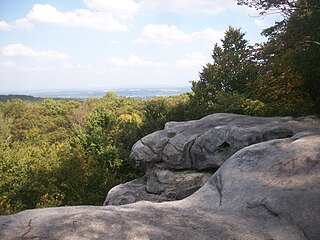
Laurel Hill, also known as Laurel Ridge or Laurel Mountain, is a 70-mile-long (110 km) mountain that is located in Pennsylvania's Allegheny Mountains. This ridge is flanked by Negro Mountain to its east and Chestnut Ridge to its west. The mountain is home to six state parks: Laurel Ridge State Park, Laurel Mountain State Park, Linn Run State Park, Kooser State Park, Laurel Hill State Park, and Ohiopyle State Park. The 70-mile-long (110 km) Laurel Highlands Hiking Trail runs the length of the ridge.

<span class="mw-page-title-main">Laurel Highlands Council</span>

Laurel Highlands Council serves youth in Allegheny, Beaver, Bedford, Blair, Cambria, Greene, Indiana, Somerset, and Washington counties in Pennsylvania; Grant, Hampshire, Hardy, and Mineral counties in West Virginia; and Allegany and Garrett counties of Maryland.

<span class="mw-page-title-main">Lost Turkey Trail</span>

The Lost Turkey Trail is a 26.3-mile (42.3 km) hiking trail in southwestern Pennsylvania. The trail traverses portions of Blue Knob State Park, a state game land, some parcels of private land, and Gallitzin State Forest. The trail is mostly in Bedford County and Somerset County, with a few segments briefly crossing the border into Cambria County. It reaches the highest point of any backpacking trail in Pennsylvania, with its eastern terminus at 3,034 feet, at Herman Point near the top of Blue Knob, which in turn is the second highest peak in the state. The trail also features a significant climb up the Allegheny Front. These rugged geographic features, combined with a shortage of camping areas and extensive no-camping zones, make the Lost Turkey Trail one of the more challenging backpacking trails in Pennsylvania.

References

  1. "Laurel Highlands - visitPA". Pennsylvania Department of Community and Economic Development. Retrieved 2011-11-06.
  2. "Hidden Valley Resort" . Retrieved 2022-03-23.
  3. "Idlewild & SoakZone: Pittsburgh's Best Amusement Park" . Retrieved 2022-03-23.
  4. "Nemacolin - Luxury Resort & Vacation Destination" . Retrieved 2022-03-23.
  5. 1 2 "Polymath Park - Wright Overnight, Tour, Dine" . Retrieved 2022-03-23.
  6. 1 2 "Seven Springs Mountain Resort" . Retrieved 2022-03-23.
  7. "Laurel Mountain - PA Pennsylvania Ski Resort" . Retrieved 2022-03-23.
  8. "The Historic Summit Inn Resort" . Retrieved 2022-03-23.
  9. "Fallingwater - Frank Lloyd Wright - Tour the house today" . Retrieved 2022-03-23.
  10. "Kentuck Knob".
  11. "Allegheny Portage Railroad National Historic Site" . Retrieved 2022-03-23.
  12. "Flight 93 National Memorial (U.S. National Park Service)" . Retrieved 2022-03-23.
  13. "Fort Necessity National Battlefield" . Retrieved 2022-03-23.
  14. "Friendship Hill National Historic Site" . Retrieved 2022-03-23.
  15. "Johnstown Flood National Memorial" . Retrieved 2022-03-23.
  16. "The 20th-Century Architecture of Frank Lloyd Wright". UNESCO. Retrieved 2022-03-23.
  17. "Nemacolin Castle" . Retrieved 2022-03-23.
  18. "Bushy Run Battlefield – Explore history" . Retrieved 2022-03-23.
  19. "Ligonier Valley Historical Society" . Retrieved 2022-03-23.
  20. "FortLigonier.org - Siege The Day" . Retrieved 2022-03-23.
  21. "Historic Hanna's Town" . Retrieved 2022-03-23.
  22. "Heritage Discovery Center" . Retrieved 2022-03-23.
  23. "Johnstown Flood Museum" . Retrieved 2022-03-23.
  24. "Johnstown Inclined Plane: Home" . Retrieved 2022-03-23.
  25. "National Road Heritage Corridor" . Retrieved 2022-03-23.
  26. "Quecreek Mine Rescue Site Foundation" . Retrieved 2022-03-23.
  27. "Lincoln Highway Heritage Corridor" . Retrieved 2022-03-23.
  28. "Somerset Historical Center" . Retrieved 2022-03-23.
  29. "Staple Bend Tunnel" . Retrieved 2022-03-23.
  30. "Borough of Somerset's Historical District" . Retrieved 2022-03-23.
  31. "Wagner-Ritter House" . Retrieved 2022-03-23.
  32. "West Overton Village" . Retrieved 2022-03-23.
  33. "Forbes State Forest". Pennsylvania Department of Conservation & Natural Resources. Retrieved 2022-03-23.
  34. "Gallitzin State Forest". Pennsylvania Department of Conservation & Natural Resources. Retrieved 2022-03-23.
  35. "Keystone State Park". Pennsylvania Department of Conservation & Natural Resources. Retrieved 2022-03-23.
  36. "Kooser State Park". Pennsylvania Department of Conservation & Natural Resources. Retrieved 2022-03-23.
  37. "Laurel Hill State Park". Pennsylvania Department of Conservation & Natural Resources. Retrieved 2022-03-23.
  38. "Laurel Mountain State Park". Pennsylvania Department of Conservation & Natural Resources. Retrieved 2022-03-23.
  39. "Laurel Ridge State Park". Pennsylvania Department of Conservation & Natural Resources. Retrieved 2022-03-23.
  40. "Laurel Summit State Park". Pennsylvania Department of Conservation & Natural Resources. Retrieved 2022-03-23.
  41. "Linn Run State Park". Pennsylvania Department of Conservation & Natural Resources. Retrieved 2022-03-23.
  42. "Ohiopyle State Park". Pennsylvania Department of Conservation & Natural Resources. Retrieved 2022-03-23.
  43. "Prince Gallitzin State Park". Pennsylvania Department of Conservation & Natural Resources. Retrieved 2022-03-23.
  44. "Coal & Coke Trail | Westmoreland County, PA - Official Website". www.co.westmoreland.pa.us. Retrieved 2022-03-23.
  45. "Ghost Town Trail Information | Indiana County Parks and Trails". www.indianacountyparks.org. Retrieved 2022-03-23.
  46. "Great Allegheny Passage". Great Allegheny Passage. Retrieved 2022-03-23.
  47. "Laurel Highlands Hiking Trail". Pennsylvania Department of Conservation & Natural Resources. Retrieved 2022-03-23.
  48. "The Jim Mayer Riverswalk Trail". Cambria County Conservation & Recreation Authority. Retrieved 2022-03-23.
  49. "Westmoreland Heritage Trail | Westmoreland County, PA - Official Website". www.co.westmoreland.pa.us. Retrieved 2022-03-23.
  50. "Five Star Trail | Westmoreland County, PA - Official Website". www.co.westmoreland.pa.us. Retrieved 2022-03-23.
  51. "HIDDEN VALLEY RESORT | PA Pennsylvania Ski Resort | Four Season Resort |" . Retrieved 2022-03-23.
  52. "Laurel Mountain | PA Pennsylvania Ski Resort | Ski Laurel Mountain" . Retrieved 2022-03-23.

40°14′28″N79°14′20″W / 40.241°N 79.239°W / 40.241; -79.239