McHenry Township is a township in Lycoming County, Pennsylvania, United States. The population was 121 at the 2020 census. It is part of the Williamsport Metropolitan Statistical Area.

Newton Hamilton is a borough in Mifflin County, Pennsylvania, United States. The population was 197 at the time of the 2020 census.

The Susquehanna River is a major river located in the Mid-Atlantic region of the United States, crossing three lower Northeast states. At 444 miles (715 km) long, it is the longest river on the East Coast of the United States. By watershed area, it is the 16th-largest river in the United States, and also the longest river in the early 21st-century continental United States without commercial boat traffic.

The Juniata River is a tributary of the Susquehanna River, approximately 104 miles (167 km) long, in central Pennsylvania. The river is considered scenic along much of its route, having a broad and shallow course passing through several mountain ridges and steeply lined water gaps. It formed an early 18th-century frontier region in Pennsylvania and was the site of French-allied Native American attacks against English colonial settlements during the French and Indian War.

The Tioga River is a tributary of the Chemung River, approximately 58 miles (93 km) long, in northern Pennsylvania and western New York in the United States. It drains a region of ridges in the northern Allegheny Plateau in the watershed of the Susquehanna River.

The Susquehannock, also known as the Conestoga, Minquas, and Andaste, were an Iroquoian people who lived in the lower Susquehanna River watershed in what is now Pennsylvania. Their name means “people of the muddy river.”

Area codes 717 and 223 are telephone area codes in the North American Numbering Plan (NANP) for South Central Pennsylvania and the Susquehanna Valley. The numbering plan area (NPA) includes the Harrisburg, Lancaster, and York metropolitan areas and a considerable portion of Pennsylvania Dutch Country, an area with nearly two million people.

Penns Creek is a 67.1-mile-long (108.0 km) tributary of the Susquehanna River in central Pennsylvania in the United States.
Crooked Creek is a 26.3-mile-long (42.3 km) tributary of the Tioga River located entirely in Tioga County, Pennsylvania in the United States.
Regions of Pennsylvania in the United States include:

Cocalico Creek is a 27.2-mile-long (43.8 km) tributary of the Conestoga River in Lebanon and Lancaster counties in Pennsylvania in the United States. The source is at an elevation of 1,320 feet (400 m) near Stricklerstown in Millcreek Township, Lebanon County. The mouth is the confluence with the Conestoga River at an elevation of 278 feet (85 m) at Talmage in West Earl Township, Lancaster County.
Conewago Creek is a 23.0-mile-long (37.0 km) tributary of the Susquehanna River in Lebanon, Dauphin, and Lancaster counties in Pennsylvania in the United States. The source is at an elevation of 1,100 feet (340 m) at Mount Gretna Heights in Lebanon County. The mouth is the confluence with the Susquehanna River at an elevation of 261 feet (80 m) at the border of Dauphin and Lancaster counties, just south of Three Mile Island in the river and just north of the unincorporated village of Falmouth in Conoy Township, Lancaster County.

Conewago Creek is an 80.2-mile-long (129.1 km) tributary of the Susquehanna River in Adams and York counties in Pennsylvania in the United States, with its watershed also draining a small portion of Carroll County, Maryland. The source is at an elevation of 1,440 feet (440 m), east of Caledonia State Park, in Franklin Township in Adams County. The mouth is the confluence with the Susquehanna River at York Haven in York County at an elevation of 259 feet (79 m).

The Lebanon Valley is a geographic region that lies between South Mountain and the Ridge and Valley Province of eastern Pennsylvania. The valley lies almost entirely within Lebanon and Berks counties in Pennsylvania. Portions of the valley lie in eastern Dauphin and northern Lancaster counties in Pennsylvania. It is bound to its southwest by the Susquehanna River and to its northeast by the adjoining Lehigh Valley.
The National Weather Service State College, Pennsylvania is a local office of the National Weather Service responsible for monitoring weather conditions in central Pennsylvania. Open since May 1993, the office serves 33 counties and has about 25 employees.
Mahantango Creek is a 2.1-mile-long (3.4 km) tributary of the Susquehanna River in Snyder and Juniata counties, Pennsylvania, in the United States. Its name comes from a Delaware Indian word meaning "where we had plenty to eat". The creek flows along the border between Snyder County and Juniata County.
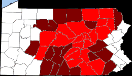
The 1964 United States presidential election in Pennsylvania took place on November 3, 1964, and was part of the 1964 United States presidential election. Voters chose 29 representatives to the Electoral College, who voted for president and vice president. Pennsylvania overwhelmingly voted for the Democratic nominee, President Lyndon B. Johnson, over the Republican nominee, Senator Barry Goldwater. Johnson won Pennsylvania by a margin of 30.22%. Apart from William Howard Taft in 1912, Goldwater's 34.7% of the vote is easily the worst showing for a Republican in the state since the party was founded. Even relative to Johnson's popular vote landslide, Pennsylvania came out as 7.64% more Democratic than the nation at-large; the only occasion under the current two-party system that the state has been more anomalously Democratic than this was in Ronald Reagan's 1984 landslide.

The Sunbury and Lewistown Railroad was a Class I Railroad connecting Lewistown, Pennsylvania with Sunbury, Pennsylvania. Completed in December 1871, the line was placed under an immediate lease by the Pennsylvania Railroad (PRR), upon its completion. Although retaining its own board of directors and track maintenance, all locomotive traffic was owned by the PRR. For over eighty years, the line operated between Sunbury and Lewistown, serving as a relief line for both the Philadelphia Main Line and Bald Eagle Valley Railroad through Williamsport, Pennsylvania. The line was noteworthy as a proving ground for new railroad technology in the United States, such as the X-shaped railroad crossing signs in 1917 and Pulse Code Cab Signaling technology in 1925. It is now a fallen flag railway, the name "Sunbury and Lewistown" having been phased out in 1901 when the line became part of the Pennsylvania Railroad's Sunbury Division.
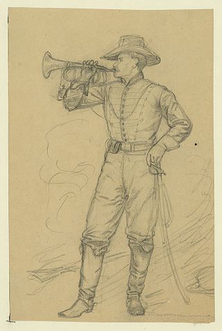
Ferdinand Frederick Rohm was a native of the German Kingdom of Württemberg who fought for the federal government of the United States during the American Civil War. He was awarded America's highest honor for valor, the U.S. Medal of Honor, for his gallantry while fighting with the Union Army as the chief bugler for the 16th Pennsylvania Cavalry during the Second Battle of Ream's Station, Virginia on August 25, 1864. As his regiment retreated under heavy enemy fire that day, he "remained behind to succor a wounded officer who was in great danger, secured assistance, and removed the officer to a place of safety." Rohm was then also severely wounded in action less than a year later as his regiment fought at Farmville, Virginia on April 7, 1865 during the war-ending Appomattox Campaign.