Franklin County, Pennsylvania

Last updated

Franklin County
Franklin County Courthouse at Night.png
Franklin County, Pennsylvania seal.png
Map of Pennsylvania highlighting Franklin County.svg
Location within the U.S. state of Pennsylvania
Pennsylvania in United States.svg
Pennsylvania's location within the U.S.
Coordinates: 39°56′N77°43′W / 39.93°N 77.72°W / 39.93; -77.72
CountryFlag of the United States.svg United States
StateFlag of Pennsylvania.svg  Pennsylvania
FoundedSeptember 9, 1784
Named for Benjamin Franklin
Seat Chambersburg
Largest boroughChambersburg
Area
  Total773 sq mi (2,000 km2)
  Land772 sq mi (2,000 km2)
  Water0.6 sq mi (2 km2)  0.08%
Population
 (2020)
  Total155,932 Increase2.svg
  Density200/sq mi (80/km2)
Time zone UTC−5 (Eastern)
  Summer (DST) UTC−4 (EDT)
Congressional district 13th
Website www.franklincountypa.gov

Franklin County is a county in the Commonwealth of Pennsylvania. As of the 2020 census, the population was 155,932. [1] Its county seat is Chambersburg. [2]

Contents

Franklin County comprises the Chambersburg–Waynesboro, PA Metropolitan Statistical Area, which is also included in the Washington–Baltimore combined statistical area. The county is part of the South Central Pennsylvania region of the state. [lower-alpha 1]

History

Originally part of Lancaster County (1729), then York County (1749), then Cumberland County (1750), Franklin County became an independent jurisdiction on September 9, 1784, relatively soon after the end of the American Revolutionary War. [3] It is named in honor of Founding Father Benjamin Franklin. [4]

Geography

Fannettsburg in rural northwestern Franklin County December 2013 Fannettsburg PA .jpg
Fannettsburg in rural northwestern Franklin County

According to the U.S. Census Bureau, the county has a total area of 773 square miles (2,000 km2), of which 772 square miles (2,000 km2) is land and 0.6 square miles (1.6 km2) (0.08%) is water. [5]

Franklin County is in the watershed of the Chesapeake Bay and the overwhelming majority of it is drained by the Potomac River, but the Conodoguinet Creek and the Shermans Creek drain northeastern portions into the Susquehanna River. It has a hot-summer humid continental climate (Dfa) and its hardiness zone is 6b. Average monthly temperatures in Chambersburg range from 29.9 °F in January to 74.7 °F in July. [6]

Adjacent counties

Major highways

Demographics

Historical population
CensusPop.Note
1790 15,662
1800 19,63825.4%
1810 23,08317.5%
1820 31,89238.2%
1830 35,0379.9%
1840 37,7937.9%
1850 39,9045.6%
1860 42,1265.6%
1870 45,3657.7%
1880 49,8559.9%
1890 51,4333.2%
1900 54,9026.7%
1910 59,7758.9%
1920 62,2754.2%
1930 65,0104.4%
1940 69,3786.7%
1950 75,9279.4%
1960 88,17216.1%
1970 100,83314.4%
1980 113,62912.7%
1990 121,0826.6%
2000 129,3086.8%
2010 149,61815.7%
2020 155,9324.2%

As of the census [7] of 2000, there were 129,313 people, 50,633 households, and 36,405 families residing in the county. The population density was 168 people per square mile (65 people/km2). There were 53,803 housing units at an average density of 70 units per square mile (27/km2). The racial makeup of the county was 95.33% White, 2.33% Black or African American, 0.15% Native American, 0.55% Asian, 0.03% Pacific Islander, 0.74% from other races, and 0.86% from two or more races. 1.75% of the population were Hispanic or Latino of any race. 40.2% were of German, 19.4% American, 7.6% Irish and 6.0% English ancestry. 96.0% spoke English and 2.1% Spanish as their first language.

There were 50,633 households, out of which 30.80% had children under the age of 18 living with them, 60.00% were married couples living together, 8.20% had a female householder with no husband present, and 28.10% were non-families. 23.70% of all households were made up of individuals, and 10.70% had someone living alone who was 65 years of age or older. The average household size was 2.49 and the average family size was 2.94.

In the county, the population was spread out, with 24.00% under the age of 18, 7.90% from 18 to 24, 28.20% from 25 to 44, 23.70% from 45 to 64, and 16.00% who were 65 years of age or older. The median age was 38 years. For every 100 females there were 94.80 males. For every 100 females age 18 and over, there were 91.90 males.

In 2001, Franklin County was featured in David Brooks' article "One Nation, Slightly Divisible" in The Atlantic as a representative Red or Republican Party county. [8]

2020 census

Franklin County Racial Composition [9]
RaceNum.Perc.
White (NH)132,56685%
Black or African American (NH)4,9983.21%
Native American (NH)2420.16%
Asian (NH)1,4081%
Pacific Islander (NH)400.03%
Other/Mixed (NH)5,9143.8%
Hispanic or Latino 10,7647%

Government

County commissioners

Source: [10]

Other county offices

Source: [11]

State House of Representatives

Source: [12]

State Senate

Source: [12]

United States House of Representatives

Politics

For most of its history, Franklin County has been a Republican Party stronghold in presidential elections, with only three Democratic Party candidates having managed to win the county from 1880 to the present day. The most recent Democrat to win the county in a presidential election was Lyndon B. Johnson, who won state-wide in the Pennsylvania election and in the national election, in a 1964 landslide. As a testament to the county's status as a Republican Party stronghold, Jimmy Carter in 1976 is the lone Democrat to win forty percent of the county's votes since Johnson's 1964 win.

Voter registration

As of February 5, 2024, there are 99,471 registered voters in the county. There are 61,383 registered Republicans, 23,279 registered Democrats, 11,351 voters registered non-affiliated voters, and 3,458 voters registered to other parties. [13]

Chart of Voter Registration

   Republican (61.71%)
   Democratic (23.40%)
   Independent (11.41%)
   Other Parties (3.48%)
United States presidential election results for Franklin County, Pennsylvania [14] [15]
Year Republican Democratic Third party
No.%No.%No.%
2020 57,24570.65%22,42227.67%1,3581.68%
2016 49,76870.59%17,46524.77%3,2734.64%
2012 43,26068.32%18,99530.00%1,0651.68%
2008 41,90665.56%21,16933.12%8421.32%
2004 41,81771.40%16,56228.28%1900.32%
2000 33,04267.41%14,92230.44%1,0552.15%
1996 25,39256.77%14,98033.49%4,3589.74%
1992 23,38753.35%13,44030.66%7,00715.99%
1988 27,08668.32%12,36831.20%1900.48%
1984 27,24370.13%11,48029.55%1220.31%
1980 22,71661.83%12,06132.83%1,9645.35%
1976 20,00956.54%14,64341.38%7372.08%
1972 24,09370.01%9,45627.48%8662.52%
1968 19,14654.40%11,45132.54%4,59813.06%
1964 13,52541.06%19,33258.68%850.26%
1960 22,01064.48%12,08835.41%360.11%
1956 19,12163.33%11,06036.63%120.04%
1952 16,47464.82%8,86834.89%740.29%
1948 12,15161.79%7,35237.39%1610.82%
1944 13,38060.13%8,80739.58%630.28%
1940 13,08450.63%12,71349.20%430.17%
1936 13,61646.29%15,63253.15%1650.56%
1932 10,99252.95%9,33844.99%4282.06%
1928 16,34583.74%3,02715.51%1460.75%
1924 9,79158.82%5,77034.67%1,0846.51%
1920 8,37660.45%5,02036.23%4613.33%
1916 5,67448.86%5,33645.95%6025.18%
1912 2,71023.52%4,50539.10%4,30837.39%
1908 6,93858.05%4,68239.17%3322.78%
1904 7,06261.76%4,11435.98%2592.26%
1900 6,48357.98%4,50040.24%1991.78%
1896 6,74758.81%4,42538.57%3002.62%
1892 5,72552.57%4,96545.59%2011.85%
1888 5,77252.27%5,08246.02%1881.70%
1884 5,57050.82%5,26148.00%1301.19%
1880 5,37951.88%4,96447.88%250.24%

United States Senate

Education

Universities and colleges

Technology school

Intermediate unit

Lincoln Intermediate Unit (IU#12) region includes: Adams County, Franklin County and York County. The agency offers school districts, home-schooled students and private schools many services, including: special education services, combined purchasing, and instructional technology services. It runs Summer Academy, which offers both art and academic strands designed to meet the individual needs of gifted, talented and high achieving students. Additional services include: curriculum mapping, professional development for school employees, adult education, nonpublic school services, business services, migrant & ESL (English as a second language), instructional services, special education, management services, and technology services. It also provides a GED program to adults who want to earn a high school diploma and literacy programs. The Lincoln Intermediate Unit is governed by a 13-member board of directors, each a member of a local school board from the 25 school districts. Board members are elected by school directors of all 25 school districts for three-year terms that begin July 1. [16] There are 29 intermediate units in Pennsylvania. They are funded by school districts, state and federal program specific funding and grants. IUs do not have the power to tax.

Public school districts

Private schools

  • Anchor Christian Day School – Shippensburg
  • Antrim Mennonite School – Greencastle
  • Brook Side Amish School – Spring Run
  • Calvary Mennonite School – Chambersburg
  • Clearfield Parochial School – Shippensburg
  • Conococheague Amish School – Spring Run
  • Corpus Christi Catholic School – Chambersburg
  • Cornell Abraxas Leadership Development Program
  • Cornell Abraxas Youth Center – South Mountain
  • Culbertson Mennonite School – Chambersburg
  • Cumberland Valley Christian School – Chambersburg
  • Emmanuel Christian School – Chambersburg
  • Franklin Learning Center – Chambersburg
  • Highfield Christian Academy – Blue Ridge Summit
  • Living Word Academy – Blue Ridge Summit
  • Maple Grove Amish School Dry Run
  • McClays Mill Amish School – Newburg
  • Meadow Brook Amish School – Spring Run
  • Manito Day Treatment – Chambersburg
  • Mercersburg Academy – Mercersburg
  • Montessori Academy of Chambersburg
  • Mountain View Amish School – Spring Run
  • Mowersville Christian Academy – Newburg
  • Noahs Ark Christian Church Center – Waynesboro
  • Otterbein School – Shippensburg
  • Path Valley Christian School – Doylesburg
  • Portico River Brethren School – Chambersburg
  • Providence School – Waynesboro
  • St. Andrew the Apostle Catholic School – Waynesboro
  • Shady Grove Mennonite School – Greencastle
  • Shalom Christian Academy – Chambersburg
  • South Mountain Secure Treatment Unit – South Mountain
  • Stoney Creek Parochial School – Orrstown
  • Sunset Amish School – Newburg
  • Sweetwater Ridge School – Dry Run
  • Sylvan Learning Center – Chambersburg
  • Tunnel Run School – Newburg
  • Visionquest-South Mountain Lodge – South Mountain
  • Willow Hill Parochial School – Willow Hill

Libraries

The Franklin County Library system has five branches:

The system also supports the Alexander Hamilton Memorial Library in Waynesboro, PA. In addition, the system currently operates two bookmobiles. [17]

Recreation

There are four Pennsylvania state parks in Franklin County.

Communities

Map of Franklin County, Pennsylvania with municipal labels showing boroughs (in red), townships (in white), and census-designated places (in blue) Map of Franklin County Pennsylvania With Municipal and Township Labels.png
Map of Franklin County, Pennsylvania with municipal labels showing boroughs (in red), townships (in white), and census-designated places (in blue)
House in Roxbury in Lurgan Township Roxbury PA FranCo 2.JPG
House in Roxbury in Lurgan Township
Chambersburg, the county seat and largest municipality in Franklin County Memorial Square Chambersburg.jpg
Chambersburg, the county seat and largest municipality in Franklin County

Under Pennsylvania law, there are four types of incorporated municipalities: cities, boroughs, townships, and, in at most two cases, towns. The following boroughs and townships are located in Franklin County:

Boroughs

Townships

Census-designated places

Census-designated places are geographical areas designated by the U.S. Census Bureau for the purposes of compiling demographic data. They are not actual jurisdictions under Pennsylvania law. Other unincorporated communities, such as villages, may be listed here as well.

Population ranking

The population ranking of the following table is based on the 2010 census of Franklin County. [18]

county seat

RankCity/Town/etc.Municipal typePopulation (2010 Census)
1 Chambersburg Borough20,268
2 Waynesboro Borough10,568
3 Shippensburg (mostly in Cumberland County )Borough5,492
4 Greencastle Borough3,996
5 Fayetteville CDP3,128
6 State Line CDP2,709
7 Wayne Heights CDP2,545
8 Guilford CDP2,138
9 Mont Alto Borough1,705
10 Mercersburg Borough1,561
11 Scotland CDP1,395
12 Marion CDP953
13 Pen Mar CDP929
14 Rouzerville CDP917
15 Blue Ridge Summit CDP891
16 Fort Loudon CDP886
17 Orrstown Borough262

See also

Related Research Articles

<span class="mw-page-title-main">Adams County, Pennsylvania</span> County in Pennsylvania, United States

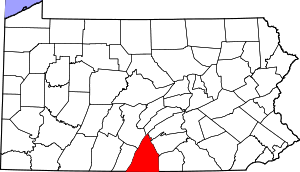
Adams County is a county in the Commonwealth of Pennsylvania. As of the 2020 census, the population was 103,852. Its county seat is Gettysburg. The county was created on January 22, 1800, from part of York County, and was named for the second President of the United States, John Adams. On July 1–3, 1863, a crucial battle of the American Civil War was fought near Gettysburg; Adams County as a result is a center of Civil War tourism. The county is part of the South Central Pennsylvania region of the state.

<span class="mw-page-title-main">Perry County, Pennsylvania</span> County in the United States

Perry County is a county in the Commonwealth of Pennsylvania. As of the 2020 census, the population was 45,842. The county seat is New Bloomfield. The county was created on March 22, 1820, and was named for Oliver Hazard Perry, a hero of the War of 1812, who had recently died. It was originally part of Cumberland County and was created in part because residents did not want to travel over the mountain to Carlisle, the county seat of Cumberland County. Landisburg became the temporary county seat before New Bloomfield was ultimately chosen. The county is part of the South Central Pennsylvania region of the state.

<span class="mw-page-title-main">Northumberland County, Pennsylvania</span> County in Pennsylvania, United States

Northumberland County is a county in the Commonwealth of Pennsylvania. As of the 2020 census, the population was 91,647. Its county seat is Sunbury. The county is part of the Central Pennsylvania region of the state.

<span class="mw-page-title-main">Mifflin County, Pennsylvania</span> County in Pennsylvania, United States

Mifflin County is a county in the Commonwealth of Pennsylvania. As of the 2020 census, the population was 46,143. Its county seat is Lewistown. The county was created on September 19, 1789, from parts of Cumberland County and Northumberland County. It was named for Thomas Mifflin, the first Governor of Pennsylvania. Mifflin County comprises the Lewistown, PA Micropolitan Statistical Area. The county is part of the Central Pennsylvania region of the state.

<span class="mw-page-title-main">Huntingdon County, Pennsylvania</span> County in Pennsylvania, United States

Huntingdon County is a county in the Commonwealth of Pennsylvania. As of the 2020 census, the population was 44,092. Its county seat is Huntingdon. The county was created on September 20, 1787, mainly from the northern part of Bedford County, plus an addition of territory on the east from Cumberland County. The county is part of the Southwest Pennsylvania region of the state.

<span class="mw-page-title-main">Fulton County, Pennsylvania</span> County in Pennsylvania, United States

Fulton County is a county in the Commonwealth of Pennsylvania. As of the 2020 census, the population was 14,556, making it the fourth-least populous county in Pennsylvania. Its county seat is McConnellsburg. The county was created on April 19, 1850, from a part of Bedford County and named after inventor Robert Fulton. The county is part of the Southwest Pennsylvania region of the state.

<span class="mw-page-title-main">Dauphin County, Pennsylvania</span> County in Pennsylvania, United States

Dauphin County is a county in the Commonwealth of Pennsylvania. As of the 2020 census, the population was 286,401. The county seat is Harrisburg, Pennsylvania's state capital and ninth-most populous city. The county was created on March 4, 1785, from part of Lancaster County and was named after Louis Joseph, Dauphin of France, the first son of King Louis XVI. The county is part of the South Central Pennsylvania region of the state.

<span class="mw-page-title-main">Antrim Township, Pennsylvania</span> Township in Pennsylvania, United States

Antrim Township is a township in Franklin County, Pennsylvania, United States. The population was 15,778 at the 2020 census, an increase over the figure of 12,504 tabulated in 2000. It was named after County Antrim in Northern Ireland.

<span class="mw-page-title-main">Chambersburg, Pennsylvania</span> Borough in Pennsylvania, United States

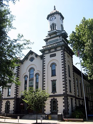
Chambersburg is a borough in and the county seat of Franklin County, in the South Central region of Pennsylvania, United States. It is in the Cumberland Valley, which is part of the Great Appalachian Valley, and 13 miles (21 km) north of Maryland and the Mason-Dixon line and 52 miles (84 km) southwest of Harrisburg, the state capital. According to the United States Census Bureau, Chambersburg's 2020 population was 21,903. When combined with the surrounding Greene, Hamilton, and Guilford Townships, the population of Greater Chambersburg is 52,273 people. The Chambersburg, PA Metropolitan Statistical Area includes surrounding Franklin County, and in 2010 included 149,618 people.

<span class="mw-page-title-main">Greencastle, Pennsylvania</span> Borough in Pennsylvania, United States

Greencastle is a borough in Franklin County in south-central Pennsylvania, United States. The population was 4,251 at the 2020 census. Greencastle lies within the Cumberland Valley of Pennsylvania.

<span class="mw-page-title-main">Washington Township, Franklin County, Pennsylvania</span> Township in Pennsylvania, United States

Washington Township is a township in Franklin County, Pennsylvania, United States. The population was 14,897 at the 2020 census, up from 14,009 at the 2010 census.

<span class="mw-page-title-main">Shippensburg, Pennsylvania</span> Borough in Pennsylvania, United States

Shippensburg is a borough in Cumberland and Franklin counties in the U.S. Commonwealth of Pennsylvania. Settled in 1730, Shippensburg lies in the Cumberland Valley, 41 miles (66 km) southwest of Harrisburg, and is part of the Harrisburg–Carlisle Metropolitan Statistical Area. The population was 5,478 at the 2020 census.

<span class="mw-page-title-main">Cumberland Valley</span> Constituent valley in the Great Appalachian Valley

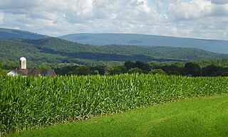
The Cumberland Valley is a northern constituent valley of the Great Appalachian Valley, within the Atlantic Seaboard watershed in Pennsylvania and Maryland. The Appalachian Trail crosses through the valley.

<span class="mw-page-title-main">Cumberland County, Pennsylvania</span> County in Pennsylvania, United States

Cumberland County is a county in the Commonwealth of Pennsylvania. As of the 2020 census, the population was 259,469. Its county seat is Carlisle. The county is part of the South Central Pennsylvania region of the state.

<span class="mw-page-title-main">Pennsylvania Route 16</span> State highway in Pennsylvania, US

Pennsylvania Route 16 is a 43-mile-long (69 km) east–west state route located in southern Pennsylvania, United States. The western terminus of the route is at U.S. Route 522 in McConnellsburg. The eastern terminus is at the Mason–Dixon line in Liberty Township, where the road continues into Maryland as Maryland Route 140. PA 16 is a two-lane road that runs through rural areas in Fulton, Franklin, and Adams counties. The route heads east from McConnellsburg and crosses Tuscarora Mountain into Franklin County, where it continues east into the agricultural Cumberland Valley. Here, the passes through Mercersburg, Greencastle, and Waynesboro. PA 16 heads east through the South Mountain range, where it heads into Adams County and passes through Carroll Valley before coming to the Maryland border. PA 16 intersects several roads including PA 456 in Cove Gap, PA 75 and PA 416 in Mercersburg, PA 995 in Upton, US 11 and Interstate 81 (I-81) in Greencastle, PA 316 and PA 997 in Waynesboro, and PA 116 in Carroll Valley. The road's main name is Buchanan Trail in honor of 15th President James Buchanan, who was born near the road in Cove Gap.

The Chambersburg, Greencastle & Waynesboro Street Railway, now defunct, was an American railroad of south central Pennsylvania built in the 19th and 20th centuries.

<span class="mw-page-title-main">Pennsylvania Route 696</span> State highway in Pennsylvania, US

Pennsylvania Route 696 is a 16.0-mile-long (25.7 km) state highway located in Franklin and Cumberland counties in Pennsylvania. The southern terminus is at PA 997 in Greene Township. The northern terminus is at PA 997 in Hopewell Township. PA 696 begins at PA 997 adjacent to an interchange with Interstate 81 (I-81) and heads northeast through farmland parallel to the interstate. The route turns north and has an interchange with I-81 before it continues into Shippensburg, where it has a brief concurrency with U.S. Route 11 and PA 533 in the downtown area. Past Shippensburg, PA 696 runs north through more farmland and heads to Newburg, where it has a short concurrency with PA 641. The route heads northwest from here to its terminus at PA 997.

<span class="mw-page-title-main">Pennsylvania Route 997</span> State highway in Pennsylvania, US

Pennsylvania Route 997 is a 49.0-mile (78.9 km) route that is located in Franklin and Cumberland counties in central Pennsylvania in the United States. This route runs from the Maryland state line south of Waynesboro, where the road continues into that state as Maryland Route 64, north to PA 233 in the Upper Mifflin Township community of McCrea.

The Franklin County Career and Technology Center is vocational high school located in Chambersburg, Pennsylvania. It serves Grades 10-12. The program at FCCTC includes half a year of academics and half a year of shop. It has six participating school districts.

<span class="mw-page-title-main">Shippensburg Area School District</span> School district in Pennsylvania

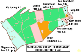
The Shippensburg Area School District is a midsized, suburban, public school district in Franklin County, Pennsylvania and Cumberland County, Pennsylvania. It is centered on the borough of Shippensburg and also serves Newburg, Hopewell Township, Shippensburg Township, and Southampton Township in Cumberland County and the adjacent and similarly named but independently governed Southampton Township along with Orrstown in Franklin County. Shippensburg Area School District encompasses approximately 121 square miles (310 km2). According to 2000 federal census data it serves a resident population of 23,714 people. By 2010, the District's population increased to 28,243 people. In 2009, the District residents’ per capita income was $15,113, while the median family income was $45,273. In the Commonwealth, the median family income was $49,501 and the United States median family income was $49,445, in 2010.

References

  1. Includes Lancaster, York, Berks, Dauphin, Cumberland, Franklin, Lebanon, Adams and Perry Counties
  1. "State & County QuickFacts". United States Census Bureau. Retrieved August 28, 2021.
  2. "Find a County". National Association of Counties. Archived from the original on May 31, 2011. Retrieved June 7, 2011.
  3. Franklin County PA – default Archived August 6, 2011, at the Wayback Machine . Co.franklin.pa.us. Retrieved on July 23, 2013.
  4. Gannett, Henry (1905). The Origin of Certain Place Names in the United States. Govt. Print. Off. pp.  131.
  5. "2010 Census Gazetteer Files". United States Census Bureau. August 22, 2012. Retrieved March 7, 2015.
  6. "PRISM Climate Group at Oregon State University".
  7. "U.S. Census website". United States Census Bureau . Retrieved January 31, 2008.
  8. David Brooks (December 2001). "One Nation, Slightly Divisible". The Atlantic . Retrieved November 11, 2010.
  9. "P2 HISPANIC OR LATINO, AND NOT HISPANIC OR LATINO BY RACE – 2020: DEC Redistricting Data (PL 94-171) – Franklin County, Pennsylvania".
  10. "Franklin County, PA". www.franklincountypa.gov. Retrieved April 25, 2017.
  11. "Franklin County, PA: Franklin County Elected Officials". www.franklincountypa.gov. Retrieved January 19, 2019.
  12. 1 2 Center, Legislativate Data Processing. "Find Your Legislator". The official website for the Pennsylvania General Assembly. Retrieved April 25, 2017.
  13. Pennsylvania Department of State (February 5, 2024). "Voter registration statistics by county". dos.pa.gov. Retrieved February 5, 2024.
  14. Leip, David. "Dave Leip's Atlas of U.S. Presidential Elections". uselectionatlas.org. Retrieved November 25, 2018.
  15. https://web.archive.org/web/20051118120032/http://geoelections.free.fr/. Archived from the original on November 18, 2005. Retrieved January 13, 2021.{{cite web}}: Missing or empty |title= (help)
  16. Lincoln Intermediate Unit 12 website accessed April 2010
  17. "Locations". August 29, 2018. Retrieved October 19, 2020.
  18. "2010 U.S. Census website". United States Census Bureau . Retrieved February 10, 2013.

39°56′N77°43′W / 39.93°N 77.72°W / 39.93; -77.72