Franklin County is a county in the Commonwealth of Pennsylvania. As of the 2020 census, the population was 155,932. Its county seat is Chambersburg.
Weissport East is a census-designated place (CDP) in Franklin Township in Carbon County, Pennsylvania. It is part of Northeastern Pennsylvania.

Middle Paxton Township is a township in Dauphin County, Pennsylvania, United States. The population was 5,046 at the 2020 census.

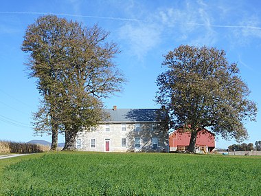
Antrim Township is a township in Franklin County, Pennsylvania, United States. The population was 15,778 at the 2020 census, an increase over the figure of 12,504 tabulated in 2000. It was named after County Antrim in Northern Ireland.

Fannett Township is a township in Franklin County, Pennsylvania, United States. The population was 2,483 at the 2020 census. The township derives its name as an older variant spelling of Fanad, County Donegal, from early Irish settlement in the area. It was formed before 1762, and until about 1795 included the area now in Metal Township.
Greene Township is a township in Franklin County, Pennsylvania, United States. The population was 18,436 at the 2020 census, up from 12,284 at the 2000 census. Part of Caledonia State Park is in Greene Township.

Guilford Township is a township in Franklin County, Pennsylvania, United States. The population was 14,627 at the 2020 census, up from 13,100 at the 2000 census.

Hamilton Township is a township in Franklin County, Pennsylvania, United States. The population was 11,374 at the 2020 census, up from 8,949 at the 2000 census.

Mercersburg is a borough in Franklin County, Pennsylvania, United States. The borough is 72 miles (116 km) southwest of Harrisburg, the state capital.

Metal Township is a township that is located in Franklin County, Pennsylvania, United States. The population was 1,768 at the time of the 2020 census.

Montgomery Township is a township that is located in Franklin County, Pennsylvania, United States. The population was 5,740 at the time of the 2020 census, an increase from the 4,949 figure that was counted during the 2000 census.

St. Thomas Township is a township in Franklin County, Pennsylvania, United States. The population was 5,917 at the 2020 census.

Warren Township is a township that is located in Franklin County, Pennsylvania, United States. The population was 328 at the time of the 2020 census.

Whiteley Township is a township that is located in Greene County, Pennsylvania, United States. The population was 569 at the time of the 2020 census, which was a decreased from the total of 649 that was documented during the 2010 census.
West Chillisquaque Township is a township in Northumberland County, Pennsylvania, United States. The population at the 2010 Census was 2,627, a decline from the figure of 2,846 tabulated in 2000.

Delano Township is a township in Schuylkill County, Pennsylvania, United States. Formed in 1882 from part of Rush Township, it is named for Warren Delano Jr., maternal grandfather of Franklin Delano Roosevelt, 32nd President of the United States, 1933–1945.

Mahanoy Township is a township in Schuylkill County, Pennsylvania, United States. The population was 3,045 at the 2020 census.

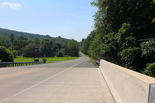
Pennsylvania Route 16 is a 43-mile-long (69 km) east–west state route located in southern Pennsylvania, United States. The western terminus of the route is at U.S. Route 522 in McConnellsburg. The eastern terminus is at the Mason–Dixon line in Liberty Township, where the road continues into Maryland as Maryland Route 140. PA 16 is a two-lane road that runs through rural areas in Fulton, Franklin, and Adams counties. The route heads east from McConnellsburg and crosses Tuscarora Mountain into Franklin County, where it continues east into the agricultural Cumberland Valley. Here, the passes through Mercersburg, Greencastle, and Waynesboro. PA 16 heads east through the South Mountain range, where it heads into Adams County and passes through Carroll Valley before coming to the Maryland border. PA 16 intersects several roads including PA 456 in Cove Gap, PA 75 and PA 416 in Mercersburg, PA 995 in Upton, US 11 and Interstate 81 (I-81) in Greencastle, PA 316 and PA 997 in Waynesboro, and PA 116 in Carroll Valley. The road's main name is Buchanan Trail in honor of 15th President James Buchanan, who was born near the road in Cove Gap.

The Tuscarora School District is a midsized, rural, public school district located in Franklin County, Pennsylvania. It serves: the borough of Mercersburg, as well as St. Thomas Township, Peters Township, Montgomery Township, and Warren Township. The district is one of the 500 public school districts of Pennsylvania. Tuscarora School District covers an area of 201 square miles (520 km2), stretching north–south from just south of 40 degrees north latitude to the Maryland border and from east of the 78 degree west longitude line to just west of Chambersburg, Pennsylvania. The district is primarily a rural agricultural area with a total population of approximately 17,000 people. Tuscarora, the name of the mountain on the western boundary, is derived from the Tuscarora Tribe of the Iroquois Confederation. The Tribe came north from the Carolinas about 1713 and settled for a time along the mountains. The name Tuscarora comes from the Indian name Skaruron or hemp gatherers. Conococheague, the name of the creek that flows through the district on its way from the Path Valley south to the Potomac River, is an Indian name from the Delaware Tribe meaning clear water.
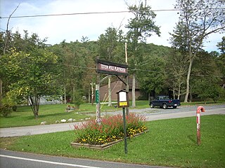
Fort Loudon (CDP) is an unincorporated community and census-designated place (CDP) in Peters Township, Franklin County, Pennsylvania, United States. As of the 2020 census, the population was 895.