Rouzerville, Pennsylvania

Last updated

Rouzerville, Pennsylvania
USA Pennsylvania location map.svg
Red pog.svg
Rouzerville
Location within Franklin county
Usa edcp location map.svg
Red pog.svg
Rouzerville
Rouzerville (the United States)
Coordinates: 39°44′5″N77°31′49″W / 39.73472°N 77.53028°W / 39.73472; -77.53028
Country United States
State Pennsylvania
County Franklin
Township Washington
Area
  Total0.7 sq mi (1.7 km2)
  Land0.7 sq mi (1.7 km2)
  Water0.0 sq mi (0.0 km2)
Elevation
720 ft (220 m)
Population
 (2020)
  Total903
  Density1,403/sq mi (541.7/km2)
Time zone UTC-5 (Eastern (EST))
  Summer (DST) UTC-4 (EDT)
ZIP code
17250
FIPS code 42-66448
GNIS feature ID1185571

Rouzerville is an unincorporated community and census-designated place (CDP) in Franklin County, Pennsylvania, United States. The population was 903 at the 2020 census. [1]

Contents

Geography

Rouzerville is located in southeastern Franklin County at 39°43′59″N77°31′21″W / 39.73306°N 77.52250°W / 39.73306; -77.52250 (39.733164, -77.522633), [2] at the foot of South Mountain, which rises to the east. The community is bordered to the southwest by Pen Mar and to the west by Wayne Heights. Pennsylvania Route 16 passes through the northern part of Rouzerville, leading east 4 miles (6 km) to Blue Ridge Summit and west 2.5 miles (4.0 km) to Waynesboro.

According to the United States Census Bureau, the CDP has a total area of 0.66 square miles (1.7 km2), all land. [3]

Demographics

As of the census [4] of 2000, there were 862 people, 367 households, and 258 families residing in the CDP. The population density was 1,321.5 inhabitants per square mile (510.2/km2). There were 388 housing units at an average density of 594.8 per square mile (229.7/km2). The racial makeup of the CDP was 97.91% White, 0.81% African American, 0.23% Native American, 0.12% from other races, and 0.93% from two or more races. Hispanic or Latino of any race were 0.12% of the population.

There were 367 households, out of which 30.5% had children under the age of 18 living with them, 56.9% were married couples living together, 8.4% had a female householder with no husband present, and 29.7% were non-families. 26.7% of all households were made up of individuals, and 12.8% had someone living alone who was 65 years of age or older. The average household size was 2.35 and the average family size was 2.81.

In the CDP, the population was spread out, with 21.2% under the age of 18, 7.1% from 18 to 24, 31.2% from 25 to 44, 24.5% from 45 to 64, and 16.0% who were 65 years of age or older. The median age was 39 years. For every 100 females, there were 98.2 males. For every 100 females age 18 and over, there were 95.1 males.

The median income for a household in the CDP was $27,031, and the median income for a family was $40,741. Males had a median income of $31,308 versus $20,647 for females. The per capita income for the CDP was $17,467. About 9.6% of families and 16.2% of the population were below the poverty line, including 16.6% of those under age 18 and 29.1% of those age 65 or over.

Related Research Articles

<span class="mw-page-title-main">Lely, Florida</span> Census-designated place in Florida

Lely is a census-designated place (CDP) in Collier County, Florida, United States. The population was 3,451 at the 2010 census. It is part of the Naples–Marco Island Metropolitan Statistical Area.

<span class="mw-page-title-main">Greentree, New Jersey</span> Populated place in Camden County, New Jersey, US

Greentree is an unincorporated community and census-designated place (CDP) located within Cherry Hill Township, in Camden County, in the U.S. state of New Jersey. As of the 2010 United States Census, the CDP's population was 11,367.

<span class="mw-page-title-main">Aspers, Pennsylvania</span> Census-designated place in Pennsylvania, United States

Aspers is a census-designated place in Adams County, Pennsylvania, United States. As of the 2020 census, it had a population of 486. At the 2000 census it was listed as the Bendersville Station-Aspers CDP.

<span class="mw-page-title-main">Lake Heritage, Pennsylvania</span> Census-designated place in Pennsylvania, United States

Lake Heritage is a census-designated place (CDP) in Adams County, Pennsylvania, United States. Its population was 2,158 at the 2020 census.

<span class="mw-page-title-main">Lenape Heights, Pennsylvania</span> Census-designated place in Pennsylvania, United States

Lenape Heights is a census-designated place (CDP) in Armstrong County, Pennsylvania, United States. The population was 1,144 at the 2020 census.

<span class="mw-page-title-main">Athens, Pennsylvania</span> Borough in Pennsylvania, United States

Athens is a borough in Bradford County, Pennsylvania, United States. It is part of Northeastern Pennsylvania and is located 2 miles (3 km) south of the New York state line on the Susquehanna and Chemung rivers. The population was 3,749 in 1900 and 3,796 in 1910. The population was 3,265 at the 2020 census. Athens is in a small area locally known as "The Valley", a group of four contiguous communities in Pennsylvania and New York: Waverly, New York; South Waverly, Pennsylvania; Sayre, Pennsylvania; and Athens. The Valley has a population near 30,000.

<span class="mw-page-title-main">Belmont, Pennsylvania</span> Census-designated place in Pennsylvania, United States

Belmont is an unincorporated community and census-designated place (CDP) in Cambria County, Pennsylvania, United States. The population was 2,784 at the 2010 census.

<span class="mw-page-title-main">Julian, Pennsylvania</span> Census-designated place in Pennsylvania, United States

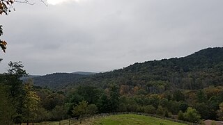
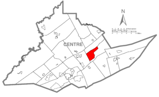
Julian is an unincorporated community and census-designated place (CDP) that is located in Centre County, Pennsylvania, United States. It is part of the State College, Pennsylvania Metropolitan Statistical Area. The population was 152 at the 2010 census. Most locals pronounce the name "Joo-lee-ānn".

<span class="mw-page-title-main">Zion, Pennsylvania</span> Census-designated place in Pennsylvania, United States

Zion is an unincorporated community and census-designated place (CDP) in Centre County, Pennsylvania, United States.

<span class="mw-page-title-main">Guys Mills, Pennsylvania</span> Census-designated place in Pennsylvania, United States

Guys Mills is a census-designated place in Crawford County, Pennsylvania, United States. The population was 124 at the 2010 census.

<span class="mw-page-title-main">Georges Township, Fayette County, Pennsylvania</span> Township in Pennsylvania, United States

Georges Township is a township in Fayette County, Pennsylvania, United States. The population was 6,341 at the 2020 census, a decline from the figure of 6,612 tabulated in 2010. It is served by the Albert Gallatin Area School District.

Guilford is a census-designated place (CDP) in Franklin County, Pennsylvania, United States. The population was 2,923 at the 2020 census.

<span class="mw-page-title-main">Hamilton Township, Franklin County, Pennsylvania</span> Township in Pennsylvania, United States

Hamilton Township is a township in Franklin County, Pennsylvania, United States. The population was 11,374 at the 2020 census, up from 8,949 at the 2000 census.

Wayne Heights is a census-designated place (CDP) in Franklin County, Pennsylvania, United States. The population was 2,606 at the 2020 census.

<span class="mw-page-title-main">Richfield, Pennsylvania</span> Census-designated place in Pennsylvania, United States

Richfield is an unincorporated community and census-designated place (CDP) in Juniata and Snyder counties in Pennsylvania, United States. The population was 549 at the 2010 census.

Yeagertown is a census-designated place (CDP) in Mifflin County, Pennsylvania, United States. The population was 1,035 at the 2000 census.

<span class="mw-page-title-main">Grantley, Pennsylvania</span> CDP in Pennsylvania, United States

Grantley is a census-designated place (CDP) in York County, Pennsylvania, United States. The population was 3,628 at the 2010 census.

<span class="mw-page-title-main">Pennville, Pennsylvania</span> CDP in Pennsylvania, United States

Pennville is a census-designated place (CDP) in York County, Pennsylvania, United States. The population was 1,947 at the 2010 census.

<span class="mw-page-title-main">Valley View, York County, Pennsylvania</span> CDP in Pennsylvania, United States

Valley View is a census-designated place (CDP) in York County, Pennsylvania, United States. The population was 2,817 at the 2010 census.

<span class="mw-page-title-main">Centerville, South Carolina</span> CDP in South Carolina, United States

Centerville is a census-designated place (CDP) in Anderson County, South Carolina. The population was 7,185 at the 2020 census.

References

  1. https://data.census.gov/all?q=Rouzerville+CDP,+Pennsylvania
  2. "US Gazetteer files: 2010, 2000, and 1990". United States Census Bureau. February 12, 2011. Retrieved April 23, 2011.
  3. "Geographic Identifiers: 2010 Census Summary File 1 (G001), Rouzerville CDP, Pennsylvania". American FactFinder. U.S. Census Bureau. Archived from the original on February 13, 2020. Retrieved August 12, 2016.
  4. "U.S. Census website". United States Census Bureau . Retrieved January 31, 2008.