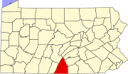
Guilford, Pennsylvania

Last updated

Guilford, Pennsylvania
USA Pennsylvania location map.svg
Red pog.svg
Guilford
Location within the U.S. state of Pennsylvania
Coordinates: 39°55′10″N77°35′54″W / 39.91944°N 77.59833°W / 39.91944; -77.59833
Country United States
State Pennsylvania
County Franklin
Townships Guilford, Greene
Area
[1]
  Total1.55 sq mi (4.01 km2)
  Land1.55 sq mi (4.01 km2)
  Water0.00 sq mi (0.00 km2)
Elevation
800 ft (200 m)
Population
 (2020) [2]
  Total2,923
  Density1,887.02/sq mi (728.45/km2)
Time zone UTC-5 (Eastern (EST))
  Summer (DST) UTC-4 (EDT)
ZIP code
17202 [3]
Area code 717
FIPS code 42-31716
GNIS feature ID2389887

Guilford is a census-designated place (CDP) in Franklin County, Pennsylvania, United States. The population was 2,923 at the 2020 census. [4]

Contents

Geography

Guilford is located in eastern Franklin County at 39°55′10″N77°35′54″W / 39.91944°N 77.59833°W / 39.91944; -77.59833 (39.919506, -77.598262). [5] It is primarily in Guilford Township, but a portion extends north into Greene Township. The area is also known as Guilford Hills. [6]

U.S. Route 30 passes through the community, leading east 2 miles (3 km) to Fayetteville and west 4 miles (6 km) to Chambersburg, the county seat.

According to the United States Census Bureau, the CDP has a total area of 1.3 square miles (3.4 km2), all land. [7]

Demographics

Historical population
CensusPop.Note
2020 2,923
U.S. Decennial Census [8]

As of the census [9] of 2000, there were 1,835 people, 731 households, and 595 families residing in the CDP. The population density was 1,467.0 inhabitants per square mile (566.4/km2). There were 751 housing units at an average density of 600.4 per square mile (231.8/km2). The racial makeup of the CDP was 95.42% White, 1.80% African American, 1.09% Asian, 0.05% Pacific Islander, 0.22% from other races, and 1.42% from two or more races. Hispanic or Latino of any race were 0.87% of the population.

There were 731 households, out of which 29.3% had children under the age of 18 living with them, 74.8% were married couples living together, 5.2% had a female householder with no husband present, and 18.5% were non-families. 16.0% of all households were made up of individuals, and 9.7% had someone living alone who was 65 years of age or older. The average household size was 2.51 and the average family size was 2.79.

In the CDP, the population was spread out, with 21.9% under the age of 18, 4.4% from 18 to 24, 21.9% from 25 to 44, 31.3% from 45 to 64, and 20.4% who were 65 years of age or older. The median age was 46 years. For every 100 females, there were 96.3 males. For every 100 females age 18 and over, there were 91.8 males.

The median income for a household in the CDP was $60,594, and the median income for a family was $62,978. Males had a median income of $44,583 versus $32,132 for females. The per capita income for the CDP was $28,723. None of the families and 2.0% of the population were living below the poverty line, including no under eighteens and 7.3% of those over 64.

Related Research Articles

<span class="mw-page-title-main">Desert View Highlands, California</span> Census designated place in California, United States

Desert View Highlands is a census-designated place (CDP) in Los Angeles County, California, United States. The population was 2,360 at the 2010 census, up from 2,337 at the 2000 census. It is surrounded by the City of Palmdale.

<span class="mw-page-title-main">Discovery-Spring Garden, Maryland</span> Former census-designated place in Maryland

Discovery-Spring Garden is a former census-designated place in Frederick County, Maryland, United States. It is the combination of the two unincorporated communities of Discovery and Spring Garden. As of the 2000 census, the population was 2,152; its population was not counted in 2010.

<span class="mw-page-title-main">Savage-Guilford, Maryland</span> Former Census-designated place in Maryland

Savage-Guilford was a census-designated place (CDP) in Howard County, Maryland, United States, for the 2000 U.S. Census, at which time its population was 12,918. It consisted of the unincorporated community communities of Savage and Guilford. At the 2010 U.S. Census, the area was re-delineated as the Savage CDP.

<span class="mw-page-title-main">Maugansville, Maryland</span> CDP in Maryland, United States

Maugansville is a census-designated place (CDP) in Washington County, Maryland, United States. The population was 2,295 at the 2000 census.

<span class="mw-page-title-main">Aspers, Pennsylvania</span> Census-designated place in Pennsylvania, United States

Aspers is a census-designated place in Adams County, Pennsylvania, United States. As of the 2020 census, it had a population of 486. At the 2000 census it was listed as the Bendersville Station-Aspers CDP.

<span class="mw-page-title-main">Lake Heritage, Pennsylvania</span> Census-designated place in Pennsylvania, United States

Lake Heritage is a census-designated place (CDP) in Adams County, Pennsylvania, United States. Its population was 2,158 at the 2020 census.

<span class="mw-page-title-main">Castanea, Pennsylvania</span> Census-designated place in Pennsylvania, United States

Castanea is a census-designated place (CDP) in Castanea Township, Clinton County, Pennsylvania, United States. The population was 1,125 at the 2010 census.

<span class="mw-page-title-main">Guys Mills, Pennsylvania</span> Census-designated place in Pennsylvania, United States

Guys Mills is a census-designated place in Crawford County, Pennsylvania, United States. The population was 124 at the 2010 census.

<span class="mw-page-title-main">Plainfield, Pennsylvania</span> Census-designated place in Pennsylvania, United States

Plainfield is a census-designated place (CDP) in Cumberland County, Pennsylvania, United States. The population was 399 at the 2010 census. It is part of the Harrisburg–Carlisle metropolitan statistical area.

Fayetteville is an unincorporated community and census-designated place (CDP) in Franklin County, Pennsylvania, United States. The population was 3,208 at the 2020 census.

<span class="mw-page-title-main">Guilford Township, Pennsylvania</span> Township in Pennsylvania, United States

Guilford Township is a township in Franklin County, Pennsylvania, United States. The population was 14,627 at the 2020 census, up from 13,100 at the 2000 census.

Rouzerville is an unincorporated community and census-designated place (CDP) in Franklin County, Pennsylvania, United States. The population was 903 at the 2020 census.

Wayne Heights is a census-designated place (CDP) in Franklin County, Pennsylvania, United States. The population was 2,606 at the 2020 census.

<span class="mw-page-title-main">New Castle Northwest, Pennsylvania</span> Census-designated place in Pennsylvania, United States

New Castle Northwest is an unincorporated area and census-designated place (CDP) in Lawrence County, Pennsylvania, United States. The population was 1,413 at the 2010 census.

Yeagertown is a census-designated place (CDP) in Mifflin County, Pennsylvania, United States. The population was 1,035 at the 2000 census.

<span class="mw-page-title-main">Grantley, Pennsylvania</span> CDP in Pennsylvania, United States

Grantley is a census-designated place (CDP) in York County, Pennsylvania, United States. The population was 3,628 at the 2010 census.

<span class="mw-page-title-main">Pennville, Pennsylvania</span> CDP in Pennsylvania, United States

Pennville is a census-designated place (CDP) in York County, Pennsylvania, United States. The population was 1,947 at the 2010 census.
<span class="mw-page-title-main">Spry, Pennsylvania</span> CDP in Pennsylvania, United States

Spry is a census-designated place (CDP) that is located in York County, Pennsylvania, United States. The population was 4,891 at the time of the 2010 census.

<span class="mw-page-title-main">Valley View, York County, Pennsylvania</span> CDP in Pennsylvania, United States

Valley View is a census-designated place (CDP) in York County, Pennsylvania, United States. The population was 2,817 at the 2010 census.

<span class="mw-page-title-main">Kendall, Washington</span> CDP in Washington, United States

Kendall is a census-designated place (CDP) in Whatcom County, Washington, United States. The population was 191 at the 2010 census.

References

  1. "ArcGIS REST Services Directory". United States Census Bureau. Retrieved October 12, 2022.
  2. "Census Population API". United States Census Bureau. Retrieved October 12, 2022.
  3. "Guilford PA ZIP Code". zipdatamaps.com. 2023. Retrieved May 13, 2023.
  4. https://data.census.gov/all?q=Guilford+CDP,+Pennsylvania
  5. "US Gazetteer files: 2010, 2000, and 1990". United States Census Bureau. February 12, 2011. Retrieved April 23, 2011.
  6. U.S. Geological Survey Geographic Names Information System: Guilford Hills, Pennsylvania
  7. "Geographic Identifiers: 2010 Census Summary File 1 (G001), Guilford CDP, Pennsylvania". American FactFinder. U.S. Census Bureau. Archived from the original on February 13, 2020. Retrieved August 12, 2016.
  8. "Census of Population and Housing". Census.gov. Retrieved June 4, 2016.
  9. "U.S. Census website". United States Census Bureau . Retrieved January 31, 2008.