The Gettysburg Area School District is a mid-sized, rural, public school district which serves students in a 185-square-mile (480 km2) area of Adams County, Pennsylvania. The district includes: Gettysburg Borough, as well as Cumberland, Freedom, Highland, Franklin and parts of Mt. Joy and Straban Townships. According to 2000 federal census data, Gettysburg Area School District served a resident population of 26,205 people. By 2010, the district's population increased to 27,614 people. The educational attainment levels for the Gettysburg Area School District population were 87.4% high school graduates and 27.4% college graduates. The district is one of the 500 public school districts of Pennsylvania.
The Cumberland Valley School District is a large, rural and suburban public school district located in Central Pennsylvania. It covers Hampden Township, Monroe Township, Middlesex Township and Silver Spring Township in Cumberland County, Pennsylvania. According to 2000 federal census data, it served a resident population of 46,926. By 2010, the district's population increased to 54,670 people. In 2009, the district residents’ per capita income was $28,440, while the median family income was $66,515. In the Commonwealth, the median family income was $49,501 and the United States median family income was $49,445, in 2010. By 2013, the median household income in the United States rose to $52,100.

The Central Greene School District is a small, rural public school district located in Greene County, Pennsylvania. The district serves: the Borough of Waynesburg and Franklin Township, Perry Township, Washington Township, Wayne Township and Whiteley Township. It encompasses approximately 168 square miles (440 km2). In 1962, the district was created through an agreed joining of school administrations in each six townships served. The district is located about sixty miles south of Pittsburgh and twenty miles north of Morgantown, West Virginia. According to the 2000 federal census data, Central Greene School District served a resident population of 16,681. By 2010, the district's population declined to 15,902 people. In 2009 the district residents' per capita income was $14,354, while the median family income was $39,358. The educational attainment levels for the population 25 and over were 84.8% high school graduates and 15.8% college graduates.
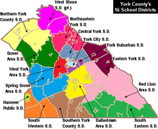
West York Area School District is a midsized, suburban public school district located in York County in South Central Pennsylvania, United States. The West York Area School District includes West York Borough and West Manchester Township. It encompasses approximately 21 square miles (54 km2). According to 2000 federal census data, it served a resident population of 21,356. By 2010, the District's population grew to 23,664 people. In 2009, the District residents’ per capita income was $21,915, while the median family income was $52,309. In the Commonwealth, the median family income was $49,501 and the United States median family income was $49,445, in 2010.

The Clearfield Area School District is a midsized, rural, public school district. The district is one of the 500 public school districts of Pennsylvania. It is located within the central and northern portion of Clearfield County, Pennsylvania. Clearfield Area School District encompasses approximately 345 square miles (890 km2). The Clearfield Area School District serves the Borough of Clearfield and Bradford Township, Covington Township, Girard Township, Goshen Township, Knox Township, Lawrence Township and Pine Township. According to 2000 federal census data, Clearfield Area School District served a resident population of 20,215 people. By 2010, the district's population declined to 19,115 people. In 2009, the district residents' per capita income was $16,245 a year, while the median family income was $37,134. In the Commonwealth, the median family income was $49,501 and the United States median family income was $49,445, in 2010. The educational attainment levels for the school district population were 85.5% high school graduates and 11.9% college graduates.
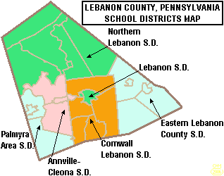
The Palmyra Area School District is the public school system in southwest Lebanon County, Pennsylvania.

Southern Columbia Area School District is a small, rural, public school district located in Catawissa, Pennsylvania. It serves communities in two counties. In Columbia County the district serves: Catawissa Borough, Catawissa Township, Locust Township, Roaring Creek Township, Franklin Township and Cleveland Township. In Northumberland County it serves Ralpho Township. Southern Columbia Area School District encompasses approximately 108 square miles (280 km2). According to 2000 federal census data, it serves a resident population of 9,803. By 2010, the US Census Bureau reported that the district's population increased to 10,386 people. The per capita income of residents was $18,969 in 2009, while the median family income was $45,889. In the Commonwealth, the median family income was $49,501 and the United States median family income was $49,445, in 2010. The district is one of the 500 public school districts of Pennsylvania.

Lower Dauphin School District is a midsized, suburban public school district located in central Pennsylvania. The district encompasses approximately 89 square miles (230 km2) and consists of Hummelstown, Pennsylvania, East Hanover Township, Pennsylvania, Londonderry Township, Dauphin County, Pennsylvania, South Hanover Township, Pennsylvania, and Conewago Township, Dauphin County, Pennsylvania. According to 2000 federal census data, the district served a resident population of 22,546. By 2010, the district's population increased to 24,747 people. The educational attainment levels for the district's population were 91.2% high school graduates and 28.2% college graduates. The district is one of the 500 public school districts of Pennsylvania.

Stroudsburg Area School District is a large, suburban/rural public school district located in the Poconos of northeast Pennsylvania. The headquarters are located on West Main Street in the Borough of Stroudsburg in Monroe County. Stroudsburg Area School District encompasses approximately 73 square miles (190 km2). According to 2000 federal census data, it served a resident population of 30,713 . By 2010, the district's population increased to 36,502 people, by 2015 it had declined to 35,787. In 2009, the district residents' per capita income was $22,137, while the median family income was $56,546. In the Commonwealth, the median family income was $49,501 and the United States median family income was $49,445, in 2010. The district is one of the 500 public school districts of Pennsylvania.

The Boyertown Area School District is a large public school district which covers portions of Berks and Montgomery Counties in southeastern Pennsylvania. When the Boyertown Area School District was formed in 1953 it was one of the largest in the state, encompassing 100 square miles (260 km2). In Berks County it covers the Boroughs of Bally, Bechtelsville and Boyertown and Colebrookdale Township, Douglass Township, Earl Township and Washington Township. In Montgomery County it covers Douglass Township, New Hanover Township and Upper Frederick Township.

Wayne Highlands is a third-class school district in Wayne County, Pennsylvania. The district's population was 20,870 at the time of the 2010 United States Census.
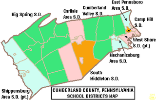
The Carlisle Area School District is a midsized, suburban, public school district that serves the boroughs of Carlisle and Mount Holly Springs and Dickinson Township and North Middleton Township in Cumberland County, Pennsylvania. Carlisle Area School District encompasses approximately 75 square miles (190 km2). According to 2000 federal census data, it serves a resident population of 34,794. in 2009, the residents' per capita income was $22,214, while the districts' median family income was $52,276.
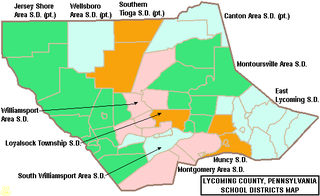
The Jersey Shore Area School District is a large rural, American, public school district that is located in Lycoming County, Pennsylvania and Clinton County, Pennsylvania. The district, which encompasses approximately 385 square miles (1,000 km2), is centered on the borough of Jersey Shore and serves the surrounding Lycoming County municipalities of Limestone Township, Bastress Township, Nippenose Township, Porter Township, Piatt Township, Anthony Township, Mifflin Township, Watson Township, Cummings Township, McHenry Township, Brown Township, and Salladasburg.
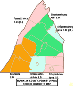
The Shippensburg Area School District is a midsized, suburban, public school district in Franklin County, Pennsylvania and Cumberland County, Pennsylvania. It is centered on the borough of Shippensburg and also serves Newburg, Hopewell Township, Shippensburg Township, and Southampton Township in Cumberland County and the adjacent and similarly named but independently governed Southampton Township along with Orrstown in Franklin County. Shippensburg Area School District encompasses approximately 121 square miles (310 km2). According to 2000 federal census data it serves a resident population of 23,714 people. By 2010, the District's population increased to 28,243 people. In 2009, the District residents’ per capita income was $15,113, while the median family income was $45,273. In the Commonwealth, the median family income was $49,501 and the United States median family income was $49,445, in 2010.
The Upper Dauphin Area School District is a small, rural, public school district located in Dauphin County, Pennsylvania. It is fragmented in four discontinuous pieces, including: the boroughs of Lykens, Elizabethville, Gratz, Berrysburg, and Pillow, as well as Jefferson Township, Washington Township, Mifflin Township, and Lykens Township. Upper Dauphin Area School District encompasses approximately 91 square miles (240 km2). According to 2007 local census data, it serves a resident population of 9,723 people. By 2010, the district's population was 9,759 people. The educational attainment levels for the district's population aged 25 years and over were 81.4% high school graduates and 10.6% college graduates.

The Waynesboro Area School District is a midsized, suburban public school district located in Franklin County, Pennsylvania. The district is one of the 500 public school districts of Pennsylvania. It encompasses the boroughs of Waynesboro and Mont Alto, as well as all of Washington Township and Quincy Township, and a portion of Guilford Township. Waynesboro Area School District encompasses approximately 93 square miles (240 km2). According to 2000 federal census data, it serves a resident population of 28,376. By 2010, the district's population increased to 32,386 people. In 2009, the district residents' per capita income was $18,503, while the median family income was $46,584. In the Commonwealth, the median family income was $49,501 and the United States median family income was $49,445, in 2010.
The Tuscarora School District is a midsized, rural, public school district located in Franklin County, Pennsylvania. It serves: the borough of Mercersburg, as well as St. Thomas Township, Peters Township, Montgomery Township, and Warren Township. The district is one of the 500 public school districts of Pennsylvania. Tuscarora School District covers an area of 201 square miles (520 km2), stretching north–south from just south of 40 degrees north latitude to the Maryland border and from east of the 78 degree west longitude line to just west of Chambersburg, Pennsylvania. The district is primarily a rural agricultural area with a total population of approximately 17,000 people. Tuscarora, the name of the mountain on the western boundary, is derived from the Tuscarora Tribe of the Iroquois Confederation. The Tribe came north from the Carolinas about 1713 and settled for a time along the mountains. The name Tuscarora comes from the Indian name Skaruron or hemp gatherers. Conococheague, the name of the creek that flows through the district on its way from the Path Valley south to the Potomac River, is an Indian name from the Delaware Tribe meaning clear water.

The Montrose Area School District is a small, rural public school district that is located in northwestern Susquehanna County, Pennsylvania. It serves the following municipalities: Montrose, Bridgewater Township, Franklin Township, Liberty Township, Jessup Township, Forest Lake Township, Silver Lake Township, Little Meadows, Choconut Township, Friendsville, and Middletown Township.
South Western School District is a midsized, suburban public school district in York County, Pennsylvania. It serves the townships of Penn Township, Manheim Township and West Manheim Township. It encompasses approximately 56 square miles (150 km2). According to 2000 federal census data, South Western School District serves a resident population of 22,576 people. By 2010, the district's population increased to 26,768 people. In 2009, South Western School District residents’ per capita income was $20,618, while the median family income was $56,296. In the Commonwealth, the median family income was $49,501 and the United States median family income was $49,445, in 2010.
The South Eastern School District is a midsized, rural, public school district in southern York County, Pennsylvania. It serves the boroughs of Cross Roads, Stewartstown, Delta, and Fawn Grove, plus the townships of Hopewell Township, East Hopewell Township, Fawn Township, and Peach Bottom Township. It also includes the villages of Bryansville and Woodbine. The district encompasses approximately 105 square miles (270 km2). According to data from the 2000 federal census, it serves a resident population of 17,884 people. By 2010, South Eastern School District's population increased to 19,567 people. In 2009, the district residents’ per capita income was $20,060, while the median family income was $55,846. In the Commonwealth, the median family income was $49,501 and the United States median family income was $49,445, in 2010.