Mountain Top, Pennsylvania

Last updated

Mountain Top, Pennsylvania
Blue Giant Meadow Lake 2.JPG
Blue Giant Meadow Lake in Mountain Top in June 2015
USA Pennsylvania location map.svg
Red pog.svg
Mountain Top
Location in Pennsylvania
Usa edcp location map.svg
Red pog.svg
Mountain Top
Location in the United States
Coordinates: 41°10′12″N75°52′36″W / 41.17000°N 75.87667°W / 41.17000; -75.87667
Country United States
State Pennsylvania
County Luzerne
Townships Nuangola, Penn Lake Park and White Haven and Dennison Township, Dorrance Township, Fairview Township, Rice Township, Slocum Township and Wright Township
Area
[1]
  Total15.02 sq mi (38.90 km2)
  Land15.02 sq mi (38.90 km2)
  Water0.00 sq mi (0.00 km2)
Elevation
1,580 ft (480 m)
Population
 (2020) [2]
  Total11,489
  Density764.86/sq mi (295.31/km2)
Time zone UTC-5 (Eastern (EST))
  Summer (DST) UTC-4 (EDT)
ZIP Code
18707
Area code(s) 570 and 272
FIPS code 42-51384
GNIS feature ID2389520

Mountain Top is an unincorporated area and census-designated place (CDP) in Luzerne County, Pennsylvania, United States. As of the 2010 census, its population was 10,982. [3]

Contents

Mountain Top is located along Pennsylvania Route 309, south of Wilkes-Barre, in Dorrance, Fairview, Rice, and Wright townships.

Name

The United States Postal Service uses the spelling "Mountain Top" for ZIP Code 18707, and the Pennsylvania Department of Transportation spells it "Mountain Top" on a Pennsylvania driver's license. However, some businesses in Mountain Top spell their community as a single word, "Mountaintop".

Geography

View of The Ice Ponds in Mountain Top in June 2015 The Ice Ponds 3.JPG
View of The Ice Ponds in Mountain Top in June 2015

Mountain Top, once named "Penobscot", [4] is located in central Luzerne County at 41°8′7″N75°54′16″W / 41.13528°N 75.90444°W / 41.13528; -75.90444 (41.1353022, -75.9044749). The CDP extends north to Solomon Gap, which separates Penobscot Knob to the west from Haystack Mountain to the east. To the south, the CDP includes the settlements of Fairview Heights, Wech Corners, Rita, Albert, Rippletown, and Lindbergh. [4] The ridge of Nescopeck Mountain is in the southeast part of Mountain Top. According to the U.S. Census Bureau, Mountain Top has a total area of 15.1 square miles (39.0 km2), all of it land. [5]

Mountain Top is in the Susquehanna River watershed. The village center sits on a drainage divide between Solomon Creek, which flows north through Solomon Gap to the Susquehanna near Wilkes-Barre, and Big Wapwallopen Creek, which flows to the southwest to the Susquehanna at Wapwallopen. East of Mountain Top, the ground rises to Arbutus Peak and Stony Cabin Ridge, both 2,080 feet (630 m) above sea level, beyond which is the Lehigh River basin leading to the Delaware River. Mountain Top is 10 miles (16 km) northwest of White Haven, at the head end of the Lehigh River, 16 miles (26 km) northeast of Hazleton, and 8 miles (13 km) south of Wilkes-Barre on Pennsylvania Route 309. Even though regional railroads are much diminished in scope and influence, Mountain Top Yard, once used as a marshaling yard at the top of the Ashley Planes' funicular railway, is still a regional element of the transportation infrastructure connecting Allentown and Philadelphia with points north and west via trackage to several yards in New York state.

The elevation in Mountain Top ranges from 1,070 feet (330 m) above sea level along Big Wapwallopen Creek in the southwest, to 1,860 feet (570 m) atop Nescopeck Mountain southwest of Rita, to 1,871 feet (570 m) at the east end of Penobscot Mountain in north Mountain Top. The central village of Mountain Top sits at 1,580 feet (480 m) just south of Penobscot Mountain.

Demographics

Historical population
CensusPop.Note
2010 10,982
2020 11,4894.6%
U.S. Decennial Census [6]

As of the 2019 census, [7] there were 11,489 people, which is a slight increase from 10,701 people in 2011. 5,556 households, and 4,394 families residing in the CDP. The population density was 224.0 inhabitants per square mile (86.5/km2). There were 5,774 housing units at an average density of 84.7 per square mile (32.7/km2). The racial makeup of the CDP was 97.02% White, 0.54% African American, 0.03% Native American, 1.62% Asian, 0.24% from other races, and 0.56% from two or more races. Hispanic or Latino of any race were 1.08% of the population.

There were 5,556 households, out of which 36.8% had children under the age of 18 living with them, 68.2% were married couples living together, 8.1% had a female householder with no husband present, and 20.9% were non-families. 18.4% of all households were made up of individuals, and 8.5% had someone living alone who was 65 years of age or older. The average household size was 2.72 and the average family size was 3.10.

In Mountain Top, the population was spread out, with 26.0% under the age of 18, 6.0% from 18 to 24, 28.7% from 25 to 44, 25.7% from 45 to 64, and 13.6% who were 65 years of age or older. The median age was 39 years. For every 100 females, there were 95.5 males. For every 100 females age 18 and over, there were 92.9 males.

The median income for a household in the CDP was $51,655, and the median income for a family was $58,588. Males had a median income of $41,271 versus $26,346 for females. The per capita income for the CDP was $22,480. About 2.9% of families and 3.4% of the population were below the poverty line, including 3.7% of those under age 18 and 5.4% of those age 65 or over.

Education

Mountain Top is located in the Crestwood Area School District, which covers over 110 square miles (280 km2) and includes Dennison Township, Dorrance Township, Fairview Township, Nuangola Borough, Rice Township, Slocum Township, White Haven Borough, Wright Township, and Penn Lake Borough.

The Crestwood School District consists of four schools:

St. Jude's Catholic School, in Wright Township, serves grades K-8, after which students can continue Catholic education at Holy Redeemer High School in Wilkes-Barre.

Related Research Articles

<span class="mw-page-title-main">Luzerne County, Pennsylvania</span> County in Pennsylvania, United States

Luzerne County is a county in the Commonwealth of Pennsylvania. According to the United States Census Bureau, the county has a total area of 906 square miles (2,350 km2), of which 890 square miles (2,300 km2) is land and 16 square miles (41 km2) is water. It is Northeastern Pennsylvania's second-largest county by total area. As of the 2020 census, the population was 325,594, making it the most populous county in the northeastern part of the state. The county seat and most populous city is Wilkes-Barre. Other populous communities include Hazleton, Kingston, Nanticoke, and Pittston. Luzerne County is included in the Scranton–Wilkes-Barre–Hazleton Metropolitan Statistical Area, which has a total population of 555,426 as of 2017.

<span class="mw-page-title-main">Jonestown, Columbia County, Pennsylvania</span> Census-designated place in Pennsylvania, United States

Jonestown is a census-designated place (CDP) in Columbia County, Pennsylvania, United States. It is part of Northeastern Pennsylvania. The population was 115 at the 2020 census. It is part of the Bloomsburg-Berwick micropolitan area.

<span class="mw-page-title-main">Lime Ridge, Pennsylvania</span> Census-designated place in Pennsylvania, United States

Lime Ridge is a census-designated place (CDP) in Columbia County, Pennsylvania, United States. It is part of Northeastern Pennsylvania. The population was 823 at the 2020 census. It is part of the Bloomsburg-Berwick micropolitan area.

<span class="mw-page-title-main">Mainville, Pennsylvania</span> Census-designated place in Pennsylvania, United States

Mainville is a census-designated place in Columbia County, Pennsylvania, United States. It is part of Northeastern Pennsylvania. The population was 134 at the 2020 census. It is part of the Bloomsburg-Berwick micropolitan area.

<span class="mw-page-title-main">Mifflinville, Pennsylvania</span> Census-designated place in Pennsylvania, United States

Mifflinville is an unincorporated community and census-designated place (CDP) in Columbia County, Pennsylvania, United States. It is part of Northeastern Pennsylvania. The population was 1,233 at the 2020 census. It is part of the Bloomsburg-Berwick micropolitan area.

<span class="mw-page-title-main">Back Mountain</span> Region in Pennsylvania, United States

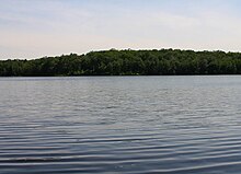
The Back Mountain is a region and former census-designated place (CDP) in Luzerne County, Pennsylvania, United States. It is near the cities of Scranton and Wilkes-Barre. The population was 33,551 as of 2016. The region has a total area of 117.59 square miles (304.6 km2). The area was not delineated as a CDP for the 2010 census. The name "Back Mountain" refers to the area's location behind the mountain ridge forming the northwest side of the Wyoming Valley. The area includes the townships of Dallas, Franklin, Jackson, Kingston, Lake, and Lehman. The region also includes the boroughs of Dallas and Harveys Lake. Each township and borough is independently governed.

<span class="mw-page-title-main">Conyngham Township, Luzerne County, Pennsylvania</span> Township in Pennsylvania

Conyngham Township is a township in Luzerne County, Pennsylvania, United States. The population was 1,309 at the 2020 census.

<span class="mw-page-title-main">Dennison Township, Pennsylvania</span> Township in Pennsylvania, United States

Dennison Township is a township in Luzerne County, Pennsylvania, United States. The population was 961 at the 2020 census.

<span class="mw-page-title-main">Dorrance Township, Pennsylvania</span> Township in Pennsylvania, United States

Dorrance Township is a township in Luzerne County, Pennsylvania, United States. The population was 2,077 at the 2020 census.

<span class="mw-page-title-main">East Berwick, Pennsylvania</span> Census-designated place in Pennsylvania, United States

East Berwick is a census-designated place (CDP) in Salem Township, Luzerne County, Pennsylvania, United States. The population was 2,007 at the 2010 census.

<span class="mw-page-title-main">Fairview Township, Luzerne County, Pennsylvania</span> Township in Pennsylvania, United States

Fairview Township is a township in Luzerne County, Pennsylvania, United States. The population was 4,691 at the 2020 census.

<span class="mw-page-title-main">Hanover Township, Luzerne County, Pennsylvania</span> Township in Pennsylvania, United States

Hanover Township is a township in Luzerne County, Pennsylvania. As of the 2020 census, the population was 11,424, making it the most populous township in the county.

<span class="mw-page-title-main">Hollenback Township, Pennsylvania</span> Township in Pennsylvania, United States

Hollenback Township is a township which is located in Luzerne County, Pennsylvania, United States. The population was 1,125 at the time of the 2020 census.

<span class="mw-page-title-main">Pittston Township, Pennsylvania</span> Township in Pennsylvania, United States

Pittston Township is a township in Luzerne County, Pennsylvania. The population was 3,179 as of the 2020 census. The township is located within the Greater Pittston region. As of 2010, the total population of Greater Pittston was 48,020. The Wilkes-Barre/Scranton International Airport is located in Pittston Township.

<span class="mw-page-title-main">Rice Township, Pennsylvania</span> Township in Pennsylvania, United States

Rice Township is a township in Luzerne County, Pennsylvania, United States. The population was 3,626 at the 2020 census.

<span class="mw-page-title-main">Wright Township, Pennsylvania</span> Township in Pennsylvania, United States

Wright Township is a township in Luzerne County, Pennsylvania, United States. The population was 5,726 at the 2020 census.

<span class="mw-page-title-main">Wilkes-Barre Township, Pennsylvania</span> First class township with home rule in Pennsylvania, United States

Wilkes-Barre Township is a township with home rule status in Luzerne County, Pennsylvania, United States. It is adjacent to the city of Wilkes-Barre. The population of the township was 3,219 at the 2020 census.

<span class="mw-page-title-main">Wilkes-Barre and Hazleton Railway</span>

The Wilkes-Barre and Hazleton Railway was an electric railway in Luzerne County, Pennsylvania connecting the cities of Wilkes-Barre and Hazleton. It operated from 1903 to 1933 using a third rail and had no grade crossings. It was approximately thirty miles long and had one tunnel between Warrior Run and Nuangola through Penobscot Knob which Interstate 81 now crosses.

<span class="mw-page-title-main">Solomon Creek</span> River of the Susquehanna River, Pennsylvania

Solomon Creek is a tributary of the Susquehanna River in Luzerne County, Pennsylvania, in the United States. It is approximately 8.8 miles (14.2 km) long and flows through Fairview Township, Hanover Township, and Wilkes-Barre. The creek is affected by acid mine drainage and has significant loads of iron, aluminum, and manganese. The creek's named tributaries are Spring Run, Sugar Notch Run, and Pine Creek. The Solomon Creek watershed is located in the Anthracite Valley section of the ridge-and-valley geographical province. Major rock formations in the watershed include the Mauch Chunk Formation, the Spechty Kopf Formation, and the Catskill Formation.

<span class="mw-page-title-main">Little Wapwallopen Creek</span> Tributary of the Susquehanna River

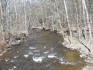
Little Wapwallopen Creek is a tributary of the Susquehanna River in Luzerne County, Pennsylvania, in the United States. It is approximately 17 miles (27 km) long and flows through Rice Township, Dorrance Township, Conyngham Township, and Hollenback Township. The watershed of the creek has an area of 39.5 square miles (102 km2). The creek is designated as a Coldwater Fishery and a Migratory Fishery and is not considered to be impaired. It has two named tributaries: Pond Creek and Nuangola Outlet. Wild trout naturally reproduce in the creek.

References

  1. "ArcGIS REST Services Directory". United States Census Bureau. Retrieved October 12, 2022.
  2. "Census Population API". United States Census Bureau. Retrieved October 12, 2022.
  3. "Total Population: 2019 Census DEC Summary File 1 (P1), Mountain Top CDP, Pennsylvania". data.census.gov. U.S. Census Bureau. Retrieved November 2, 2020.
  4. 1 2 "Mountain Top, PA; Penobscot, PA". Acme Mapper. U.S. Geological Survey 7-1/2 minute topographic map series. Retrieved November 2, 2020.
  5. "2019 U.S. Gazetteer Files: Places: Pennsylvania". United States Census Bureau. Retrieved November 2, 2020.
  6. "Census of Population and Housing". Census.gov. Retrieved June 4, 2016.
  7. "U.S. Census website". United States Census Bureau . Retrieved January 31, 2008.