
Butler Township is a township in Luzerne County, Pennsylvania, United States. The population was 9,221 at the 2010 census.
Hazle Township is a township in Luzerne County, Pennsylvania. The population was 9,549 at the time of the 2010 census. The township surrounds the city of Hazleton and the borough of West Hazleton.

Sugarloaf Township is a township in Luzerne County, Pennsylvania, United States. The population was 4,211 at the 2010 census.
Hazle is a surname. Notable people with this name include:

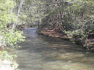
Black Creek is a long source tributary of Nescopeck Creek so part of the Susquehanna River drainage basin. It is also the second & longer stream of the same name recognized by the USGS GNIS system in Luzerne County, Pennsylvania, in the United States—compared to the Black Creek beyond the ridgeline of the drainage divide, so in the Lehigh River valley and Carbon County. The headwaters of both Black Creeks in Luzerne county are only a few miles apart, and both valleys were traversed by the Lausanne-Nescopeck Turnpike in the first half of the 19th-century.
Pennsylvania Route 424 is a 3.75-mile-long (6.04 km) state highway located in north-central Pennsylvania. The western terminus is at Interstate 81 (I-81) exit 141 in Hazle Township. The eastern terminus is at PA 93 on the southeastern edge of Hazleton. The highway is called the Greater Hazleton Chamber Of Commerce Beltway or Arthur Gardner Highway and is a two-lane undivided road that forms a southern bypass of the city of Hazleton in Luzerne County, with an intermediate intersection with PA 309. The section of the road between PA 309 and PA 93 was constructed by 1980 and became State Route 3032. The road was extended west to I-81 in 1999, and PA 424 was designated between I-81 and PA 93 in 2000. PA 424 was constructed to provide access to the Hazleton Commerce Center and to reduce truck traffic on adjacent roads. There are plans to extend the route west to PA 924 near Humboldt Industrial Park.
Pennsylvania Route 924 is a 22-mile-long (35 km) state highway in the U.S. state of Pennsylvania. The highway runs from PA 61 in Frackville, Schuylkill County northeast to PA 309 in Hazleton, Luzerne County. PA 924 runs through rural areas in the Coal Region, serving Gilberton, Shenandoah, Brandonville, and West Hazleton. The route is mostly a two-lane road with the section between Frackville and Shenandoah a four-lane divided highway with an interchange serving Gilberton and another four-lane divided highway section to the west of Hazleton. PA 924 intersects PA 54 in Shenandoah, PA 339 in Brandonville, Interstate 81 (I-81) west of Hazleton, and PA 93 in West Hazleton.
Pardeesville is a census-designated place (CDP) in Hazle Township, Luzerne County, Pennsylvania, United States. The population was 572 at the 2010 census.
Harleigh is a census-designated place (CDP) in Hazle Township, Luzerne County, Pennsylvania, United States, north of the city of Hazleton. The CDP population was 1,104 at the 2010 census.

The Hazleton Area School District is a large, rural public school district in Pennsylvania, stretching over portions of Luzerne, Schuylkill, and Carbon Counties. Its headquarters are in Hazle Township.
Tomhicken Creek is a stream in Luzerne County and Schuylkill County, in Pennsylvania, in the United States. It is approximately 11 miles (18 km) long and is the largest tributary of Catawissa Creek. Named tributaries of the creek include Little Crooked Run, Little Tomhicken Creek, Raccoon Creek, and Sugarloaf Creek. The watershed of the main stem has an area of 20.6 square miles. A number of mine tunnels discharge into the creek and its tributaries.
Sugarloaf Creek is a tributary of Tomhicken Creek in Luzerne County and Schuylkill County, in Pennsylvania, in the United States. It is approximately 3.5 miles (5.6 km) long and flows through Hazle Township and Black Creek Township in Luzerne County and North Union Township in Schuylkill County. The watershed of the stream has an area of 3.34 square miles (8.7 km2). The stream is considered to be a Coldwater Fishery. The main rock formation in the stream's watershed are the Mauch Chunk Formation and the main soil is the Hazleton soil. The creek has been impaired by acid mine drainage from the Oneida Number One Tunnel.
Hunkydory Creek is a tributary of Catawissa Creek in Schuylkill County and Luzerne County, in Pennsylvania, in the United States. It is approximately 1.4 miles (2.3 km) long and flows through Kline Township in Schuylkill County and Hazle Township in Luzerne County. The watershed of the creek has an area of 3.65 square miles (9.5 km2). The creek is considered to be a Coldwater Fishery. It is likely that it is not inhabited by any species of fish. The main rock formations in the creek's watershed are the Mauch Chunk Formation, the Pottsville Formation, and the Llwellyn Formation and the main soils are the Udorthents Kill soil and the Hezleton soil.
Little Black Creek is a tributary of Black Creek in Luzerne County, Pennsylvania, in the United States. It is approximately 2.2 miles (3.5 km) long and flows through Lattimer, Harleigh, and Hazle Township. The watershed of the creek is largely on coal mining land. It only has an intermittent flow and some of its waters drain into the Jeddo Tunnel instead of Black Creek. The creek is in the Eastern Middle Anthracite Field. There is at least one bridge crossing the creek.
Stony Creek is a tributary of Black Creek in Luzerne County, Pennsylvania, in the United States. It is approximately 3.7 miles (6.0 km) long and flows through Hazle Township and West Hazleton. Its named tributaries include Cranberry Creek and Wolffs Run. Stony Creek is considered to be impaired by acid mine drainage and also has measurable concentrations of iron, aluminum, and manganese. The Llwellyn Formation and the Mauch Chunk Formation can be found near the creek. Land uses in its watershed include forested land and barren land. A reservoir has been constructed in the watershed and at least one bridge has been built over the creek. The creek is considered to be a coldwater fishery and a migratory fishery.
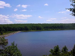
Wolffs Run is a tributary of Stony Creek in Luzerne County, Pennsylvania. It is approximately 0.4 miles (0.64 km) long and flows through Hazle Township. The watershed of the stream has an area of 0.6 square miles (1.6 km2). A reservoir known as the Humboldt Reservoir is located on it. The reservoir serves as a water supply and is dammed by the Humboldt Dam.
Drifton is an unincorporated community located in Hazle Township in Luzerne County, Pennsylvania. Drifton is located along Pennsylvania Route 940, northwest of Jeddo and southwest of Freeland.
Ebervale is an unincorporated community located in Hazle Township in Luzerne County, Pennsylvania. Ebervale is located along Pennsylvania Route 940, northeast of Hazleton and west of Jeddo. The village takes its name from an Anglicization of the place name Ebbw Vale, a town in Wales.
Milnesville is an unincorporated community located in Hazle Township in Luzerne County, Pennsylvania. Milnesville is located along Pennsylvania Route 309, a short distance south of the Airport Beltway intersection to the north of Hazleton.
Cranberry is an unincorporated community in Hazle Township, Luzerne County, Pennsylvania, United States.


