
Sullivan County is a county located in the U.S. state of Pennsylvania. As of the 2010 census, the population was 6,428, making it the second-least populous county in Pennsylvania. Its county seat is Laporte. The county was created on March 15, 1847, from part of Lycoming County and named for Charles C. Sullivan, leader of the Pennsylvania Senate at that time.

Black Creek Township is a township in Luzerne County, Pennsylvania, United States. The population was 2,016 as of the 2010 census.

Ricketts Glen State Park is a Pennsylvania state park on 13,193 acres (5,280 ha) in Columbia, Luzerne, and Sullivan counties in Pennsylvania in the United States. Ricketts Glen is a National Natural Landmark known for its old-growth forest and 24 named waterfalls along Kitchen Creek, which flows down the Allegheny Front escarpment from the Allegheny Plateau to the Ridge-and-Valley Appalachians. The park is near the borough of Benton on Pennsylvania Route 118 and Pennsylvania Route 487, and is in five townships: Sugarloaf in Columbia County, Fairmount and Ross in Luzerne County, and Colley and Davidson in Sullivan County.

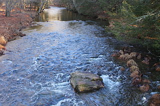
Black Creek is a long source tributary of Nescopeck Creek so part of the Susquehanna River drainage basin. It is also the second & longer stream of the same name recognized by the USGS GNIS system in Luzerne County, Pennsylvania, in the United States—compared to the Black Creek beyond the ridgeline of the drainage divide, so in the Lehigh River valley and Carbon County. The headwaters of both Black Creeks in Luzerne county are only a few miles apart, and both valleys were traversed by the Lausanne-Nescopeck Turnpike in the first half of the 19th-century.

Nescopeck State Park is a Pennsylvania state park on 3,550 acres (1,437 ha) in Butler and Dennison Townships, Luzerne County, Pennsylvania. The park is one of the newest state parks in Pennsylvania. In the early 1970s, the state acquired 164 properties which made up the park. The park's Environmental Education Center is one of its newest additions; it opened in April 2005. Nescopeck Creek runs through the valley between Mount Yeager and Nescopeck Mountain. The park is near Interstate 80 just off Pennsylvania Route 309.
Huntington Creek is a tributary of Fishing Creek in Luzerne and Columbia counties, Pennsylvania, in the United States. It is approximately 29.5 miles (47.5 km) long.
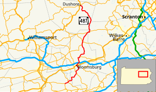
Pennsylvania Route 487 is a 64.2-mile-long (103.3 km), north–south state highway running from PA 61 in Shamokin Township, Northumberland County to PA 87 in Dushore, Sullivan County. In Bloomsburg, PA 487 and US 11 share a brief wrong-way concurrency. After its brief concurrency with PA 118, PA 487 goes up a steep grade through Ricketts Glen State Park. PA 487 is used to carry traffic up the Fishing Creek valley.

Pennsylvania Route 118 (PA 118) is a 42.248-mile-long (67.992 km) state route located in northeastern Pennsylvania. The western terminus of the route is at PA 405 in Hughesville. The eastern terminus is at PA 415 in Dallas. The road is known briefly as East Water Street from its western terminus to its intersection with 6th Street in Hughesville, where it becomes Lairdsville Road for 12 miles (19 km) until crossing PA 42 near Unityville. It joins PA 487 for one mile (1.6 km) in Red Rock, where it passes through the southern part of Ricketts Glen State Park. In 1928, the road between Hughesville and Unityville was designated as part of PA 642 while the portion between Red Rock and Lehman was designated as a portion of PA 115. PA 642 was extended from PA 42 in Unityville to PA 539 in the 1940s. During the 1950s, PA 115 was rerouted from Red Rock to head west and replace PA 642 to Hughesville. PA 115 was also realigned to run between Lehman and Dallas. In 1961, PA 118 replaced the portion of PA 115 between Hughesville and Dallas.

Kitchen Creek is a tributary of Huntington Creek in Luzerne County, Pennsylvania, in the United States. It is approximately 10.6 miles (17.1 km) long and flows through Fairmount Township and Huntington Township. The watershed of the creek has an area of 20.10 square miles (52.1 km2). The creek is designated as a high-quality coldwater fishery.
Newport Creek is a tributary of the Susquehanna River in Luzerne County, Pennsylvania, in the United States. It is 4.9 miles (7.9 km) in length. Named tributaries of the creek include South Branch Newport Creek. The entire watershed of Newport Creek is considered by the Pennsylvania Department of Environmental Protection to be impaired.
Sugarloaf Creek is a tributary of Tomhicken Creek in Luzerne County and Schuylkill County, in Pennsylvania, in the United States. It is approximately 3.5 miles (5.6 km) long and flows through Hazle Township and Black Creek Township in Luzerne County and North Union Township in Schuylkill County. The watershed of the stream has an area of 3.34 square miles (8.7 km2). The stream is considered to be a Coldwater Fishery. The main rock formation in the stream's watershed are the Mauch Chunk Formation and the main soil is the Hazleton soil. The creek has been impaired by acid mine drainage from the Oneida Number One Tunnel.
The Oneida Number One Tunnel is a mine drainage tunnel in Schuylkill County, Pennsylvania, in the United States. It is one of five major mine tunnels in the watershed of Catawissa Creek. The tunnel discharges into Sugarloaf Creek near Lake Choctaw and Lake Susquehanna. The water quality of the tunnel's discharge has improved significantly since the installation of a treatment system at the site of the tunnel in 2001.

Nescopeck Mountain is a ridge in Columbia County and Luzerne County, in Pennsylvania, in the United States. Its elevation is 1,594 feet (486 m) above sea level. The ridge is a forested ridge, with at least two types of forest and two systems of vernal pools. It is a very long and unbroken ridge with two water gaps: one carved by Catawissa Creek and one carved by Nescopeck Creek. This later gap was exploited as a transportation corridor with the construction of the Lehigh & Susquehanna Turnpike between the respective frontier communities at Lausanne Landing and Nescopeck in 1805 connecting the newly developing Wyoming Valley with Philadelphia and the Delaware River valley; cutting off over 100 miles between Philadelphia and Wilkes-Barre. Today's Route PA 93 derives from this historic pack mule road.

Central Mountain is a mountain in Columbia County, Sullivan County, and Luzerne County, in Pennsylvania, United States. Its elevation is 2,247 feet (685 m) above sea level. The mountain is part of the Allegheny Front. Rock formations on the mountain include the Pocono Formation and the Duncannon Member of the Catskill Formation. It was historically known as North Mountain, but it was renamed Central Mountain in the late 1800s. The mountain is one of the most important sites on the Columbia County Natural Areas Inventory and it is inhabited by dozens of trees, shrubs, and herbaceous plants. Numerous birds and several amphibians and mammals are also found in the area.

Pond Creek is a tributary of Little Wapwallopen Creek in Luzerne County, Pennsylvania, in the United States. It is approximately 6.4 miles (10.3 km) long and flows through Slocum Township and Conyngham Township. The watershed of the creek has an area of 9.69 square miles (25.1 km2) and is part of the Lower North Branch Susquehanna drainage basin. A bridge was built over the creek in 1956. In the early 1900s, the Glen Brook Water Company planned to construct a dam on the creek. The surficial geology in the vicinity of Pond Creek includes Wisconsinan Till, alluvium, boulder alluvium, alluvial fan, and bedrock consisting of sandstone and shale, as well as some patches of wetland.

Hunlock Creek is a tributary of the Susquehanna River in Luzerne County, Pennsylvania, in the United States. It is approximately 7.8 miles (12.6 km) long and flows through Lehman Township and Hunlock Township. The watershed of the creek has an area of 32.5 square miles (84 km2) and is situated in northwestern Luzerne County. It has one named tributary, which is known as Roaring Brook, and a number of unnamed and unofficially named tributaries, such as "West Branch Hunlock Creek".
Scotch Run (also known as Scotch Run Creek is a tributary of Black Creek in Luzerne County, Pennsylvania, in the United States. It is approximately 1.6 miles long and flows through Black Creek Township. The stream is fed by springs and is located at the base of Nescopeck Mountain. It has not been assessed by the Pennsylvania Fish and Boat Commission.
Falls Run is a tributary of Black Creek in Columbia County and Luzerne County, in Pennsylvania, in the United States. It is approximately 3.1 miles (5.0 km) long and flows through Beaver Township in Columbia County and Black Creek Township in Luzerne County. The watershed of the stream has an area of at least 2.44 square miles (6.3 km2). The stream was historically used as a water supply and one bridge crosses it. It is in the vicinity of Buck Mountain.

South Branch Bowman Creek is a tributary of Bowman Creek in Luzerne County, Pennsylvania, in the United States. It is approximately 3.0 miles (4.8 km) long and flows through Fairmount Township and Ross Township. The watershed of the creek has an area of 3.92 square miles (10.2 km2). The surficial geology in its vicinity consists of alluvial fan, alluvium, Wisconsinan Ice-Contact Sratified Drift, fill, lakes, Boulder Colluvium, Wisconsinan Till, Wisconsinan Bouldery Till, wetlands, and bedrock. Most of the creek is in Ricketts Glen State Park. It has one named tributary, which is known as Cherry Run. The creek's watershed is designated as a High-Quality Coldwater Fishery and a Migratory Fishery.

Cherry Run is a tributary of South Branch Bowman Creek in Luzerne County, Pennsylvania, in the United States. It is approximately 2.1 miles (3.4 km) long and flows through Fairmount Township and Ross Township. The watershed of the stream has an area of 1.65 square miles (4.3 km2). The surficial geology in its vicinity consists of alluvial fan, alluvium, bedrock, Wisconsinan Till, wetlands, and a peat bog. The stream has cascades and contains wild trout.


