Conyngham, Pennsylvania

Last updated
Conyngham, Pennsylvania
Borough
Pennsylvania Route 93 in Conyngham during a traffic jam.JPG
Pennsylvania Route 93 in Conyngham
Luzerne County Pennsylvania Incorporated and Unincorporated areas Conyngham Highlighted.svg
Location of Conyngham in Luzerne County, Pennsylvania.
USA Pennsylvania location map.svg
Red pog.svg
Conyngham
Usa edcp location map.svg
Red pog.svg
Conyngham
Coordinates: 40°59′24″N76°03′42″W / 40.99000°N 76.06167°W / 40.99000; -76.06167
Country United States
State Pennsylvania
County Luzerne
Settledlate 1700s
Incorporated1921
Government
  TypeBorough Council
   Mayor Tricia Marnell
Area
[1]
  Total1.03 sq mi (2.66 km2)
  Land1.03 sq mi (2.66 km2)
  Water0.00 sq mi (0.00 km2)
Elevation
1,014 ft (309 m)
Population
 (2020) [2]
  Total1,825
  Density1,778.75/sq mi (687.08/km2)
Time zone UTC-5 (Eastern (EST))
  Summer (DST) UTC-4 (EDT)
Zip code
18219
Area code 570
FIPS code 42-15888
Website www.conynghamborough.org

Conyngham is a borough in Luzerne County, Pennsylvania, United States. The population was 1,820 at the 2020 census. [3]

Contents

History

Gustavus Conyngham Gustavus Conyngham.jpg
Gustavus Conyngham

The first settler of Conyngham was George Drum (in the late 1700s) [4] who served in the American Revolution and was elected justice of the peace in 1811. [5] [6] George Drum was an entrepreneurial businessman and was a large landowner who also owned the Drums Hotel, a shoe shop, tavern, and the Drums Post Office. He and his family developed the adjacent village of Drums, of which the village is named after the family, along with helping the development of Conyngham. Drums is a sister village to Conyngham. The George Drum residence remains standing in impeccable condition on Conyngham's Main Street. [7]

The Sugarloaf Massacre of September 11, 1780, was one of a series of bloody engagements fought in the frontier of northeastern Pennsylvania between Iroquois (allies of British troops) and settlers loyal to the cause of American independence. Today, this event is commemorated by a historic monument with a bronze plaque bearing the names of the fifteen men who lost their lives near modern-day Conyngham.

In 1815, Redmond Conyngham represented Luzerne County in the Pennsylvania House of Representatives. In 1820, he served a term in the State Senate. Captain Gustavus Conyngham was his cousin. He was an unsung hero of the Revolution. He commanded a privateer and was the first to carry the American flag in the English Channel. The townspeople suggested naming the village after Redmond Conyngham, but he replied that the town should be named in honor of his cousin, Gustavus, who frequently made trips to England to obtain military supplies for revolutionary colonists. [8]

In the 1800s, the Lehigh-Susquehanna Turnpike traveled through the middle of modern-day Main Street in Conyngham. [9] PA 93 was later constructed as another route through the town. It was not until 1921 when Conyngham became a borough.

Geography

Conyngham is located at 40°59′24″N76°3′42″W / 40.99000°N 76.06167°W / 40.99000; -76.06167 (40.990051, -76.061655). [10]

According to the United States Census Bureau, the borough has a total area of 1.0 square mile (2.6 km2), all land. Sugarloaf Township encircles Conyngham. Pennsylvania Route 93 runs through the borough. Conyngham is located near Interstate 80 (to the north) and 81 (to the south and east).

Attractions

Conyngham has a town park called Whispering Willows. At the park, there is a community pool owned by the Conyngham Valley Civic Organization (CVCO). The Hazleton Area Library, Conyngham Branch, is also located nearby.

Restaurants

Demographics

Historical population
CensusPop.Note
1910 406
1920 385−5.2%
1930 52235.6%
1940 74442.5%
1950 93525.7%
1960 1,16324.4%
1970 1,85059.1%
1980 2,24221.2%
1990 2,060−8.1%
2000 1,958−5.0%
2010 1,914−2.2%
2020 1,820−4.9%
2021 (est.)1,818 [3] −0.1%
Sources: [11] [12] [13] [14] [2]

As of the census [12] of 2000, there were 1,958 people, 793 households, and 574 families residing in the borough. The population density was 1,834.8 inhabitants per square mile (708.4/km2). There were 817 housing units at an average density of 765.6 per square mile (295.6/km2).

The racial makeup of the borough was 97.40% White, 0.05% African American, 2.25% Asian, and 0.31% from two or more races. Hispanic or Latino of any race were 0.72% of the population.

There were 793 households, out of which 30.3% had children under the age of 18 living with them, 61.9% were married couples living together, 8.8% had a female householder with no husband present, and 27.5% were non-families. 23.8% of all households were made up of individuals, and 14.1% had someone living alone who was 65 years of age or older. The average household size was 2.47 and the average family size was 2.95.

In the borough the population was spread out, with 24.0% under the age of 18, 5.5% from 18 to 24, 23.8% from 25 to 44, 28.1% from 45 to 64, and 18.6% who were 65 years of age or older. The median age was 43 years. For every 100 females there were 89.7 males. For every 100 females age 18 and over, there were 84.6 males.

The median income for a household in the borough was $48,529, and the median income for a family was $59,083. Males had a median income of $49,732 versus $22,226 for females. The per capita income for the borough was $26,352. About 2.1% of families and 3.8% of the population were below the poverty line, including 8.1% of those under age 18 and 1.1% of those age 65 or over.

Related Research Articles

<span class="mw-page-title-main">Carbon County, Pennsylvania</span> County in Pennsylvania, United States

Carbon County is a county in the Commonwealth of Pennsylvania. It is located in Northeastern Pennsylvania. As of the 2020 census, the population was 64,749. The county is also part of Pennsylvania's Coal Region and Northeastern Pennsylvania.

<span class="mw-page-title-main">Lansford, Pennsylvania</span> Borough in Pennsylvania, United States

Lansford is a county-border borough (town) in Carbon County, Pennsylvania, United States. It is part of Northeastern Pennsylvania. It is located 37 miles (60 km) northwest of Allentown and 19 miles south of Hazleton in the Panther Creek Valley about 72 miles (116 km) from Philadelphia and abutting the cross-county sister-city of Coaldale in Schuylkill County.

<span class="mw-page-title-main">Nesquehoning, Pennsylvania</span> Borough in Pennsylvania, United States

Nesquehoning is a borough in Carbon County, Pennsylvania, United States. It is part of Northeastern Pennsylvania. The population was 3,336 at the 2020 census.

<span class="mw-page-title-main">Tresckow, Pennsylvania</span> Census-designated place in Pennsylvania, United States

Tresckow, formerly known as Dutchtown, is an unincorporated community and census-designated place (CDP) in Carbon County, Pennsylvania, United States. It is part of Northeastern Pennsylvania and is located west of Junedale and Beaver Meadows, which share the same road network. The community has deep roots in the anthracite coal mining and transportation industries.

<span class="mw-page-title-main">Sugarloaf Township, Columbia County, Pennsylvania</span> Township in Pennsylvania, United States

Sugarloaf Township is a township in Columbia County, Pennsylvania. It is part of Northeastern Pennsylvania.

<span class="mw-page-title-main">Black Creek Township, Luzerne County, Pennsylvania</span> Township in Pennsylvania, United States

Black Creek Township is a township in Luzerne County, Pennsylvania, United States. The population was 1,904 as of the 2020 census.

<span class="mw-page-title-main">Butler Township, Luzerne County, Pennsylvania</span> Township in Pennsylvania, United States

Butler Township is a township in Luzerne County, Pennsylvania, United States. The population was 9,469 at the 2020 census.

<span class="mw-page-title-main">Conyngham Township, Luzerne County, Pennsylvania</span> Township in Pennsylvania

Conyngham Township is a township in Luzerne County, Pennsylvania, United States. The population was 1,309 at the 2020 census.

<span class="mw-page-title-main">Freeland, Pennsylvania</span> Borough in Pennsylvania, United States

Freeland is a borough in Luzerne County, Pennsylvania, United States. It was originally called Birbeckville, South Heberton, and Freehold. Freeland is 18 miles (29 km) south of Wilkes-Barre and 10 miles (16 km) northeast of Hazleton. It was incorporated as a borough on September 11, 1876. Coal mining was the chief industry in the community through the mid-20th century. As of the 2020 census, the population was 3,833.

<span class="mw-page-title-main">Hazle Township, Luzerne County, Pennsylvania</span> Township in Pennsylvania, United States

Hazle Township is a township in Luzerne County, Pennsylvania, United States. The population was 10,150 at the time of the 2020 census. The township surrounds the city of Hazleton and the borough of West Hazleton.

<span class="mw-page-title-main">Hazleton, Pennsylvania</span> City in Pennsylvania, United States

Hazleton is a city in Luzerne County, Pennsylvania, United States. The population was 29,963 at the 2020 census. Hazleton is the second largest city in Luzerne County. It was incorporated as a borough on January 5, 1857, and as a city on December 4, 1891.

<span class="mw-page-title-main">Hollenback Township, Luzerne County, Pennsylvania</span> Township in Pennsylvania, United States

Hollenback Township is a township which is located in Luzerne County, Pennsylvania, United States. The population was 1,125 at the time of the 2020 census.

<span class="mw-page-title-main">Sugarloaf Township, Luzerne County, Pennsylvania</span> Township in Pennsylvania, United States

Sugarloaf Township is a townshipthat is located in Luzerne County, Pennsylvania, United States. The population was 3,879 at the time of the 2020 census.

<span class="mw-page-title-main">West Hazleton, Pennsylvania</span> Borough in Pennsylvania, United States

West Hazleton is a borough in Luzerne County, Pennsylvania, United States. The borough is 31 miles (50 km) south of Wilkes Barre and had a population of 5,167 as of the 2020 census.

<span class="mw-page-title-main">White Haven, Pennsylvania</span> Borough in Pennsylvania, United States

White Haven is a borough in Luzerne County, Pennsylvania, United States. It is located along the Lehigh River. The population was 1,163 at the 2020 census.

<span class="mw-page-title-main">Mahanoy City, Pennsylvania</span> Borough in Pennsylvania, United States

Mahanoy City is a borough located 38 miles (61 km) southwest of Wilkes-Barre and 13 miles southwest of Hazleton, in northern Schuylkill County, Pennsylvania, United States. It is part of the Coal Region of Pennsylvania and is located entirely within, but is not part of, Mahanoy Township.

<span class="mw-page-title-main">Nuremberg, Pennsylvania</span> Census-designated place in Pennsylvania, United States

Nuremberg is a census-designated place (CDP) that is located in Schuylkill and Luzerne counties, Pennsylvania, United States. The population was 434 at the time of the 2010 census.

<span class="mw-page-title-main">Pennsylvania Route 93</span> State highway in Pennsylvania, US

Pennsylvania Route 93 is a 41-mile-long (66 km) state route located in Carbon, Luzerne, and Columbia counties in northeastern Pennsylvania. The southern terminus is at U.S. Route 209 in Nesquehoning, about halfway from PA just north of the 1800s community of Lausanne Landing, the southern toll station of the Lausanne & Nescopeck Turnpike (1804)—along whose path the highway was built. The northern terminus of the route is at PA 487 in Orangeville, the part of the road west of the Susquehanna and Berwick once being part of the Susquehanna & Tioga Turnpike (1806).

<span class="mw-page-title-main">Hazleton Area School District</span> School district in Pennsylvania

The Hazleton Area School District is a large, rural public school district in Pennsylvania, stretching across portions of Luzerne, Schuylkill, and Carbon Counties. Its headquarters are in Hazle Township. Students in grade nine through 12 attend Hazleton Area High School.

<span class="mw-page-title-main">Drums, Pennsylvania</span>

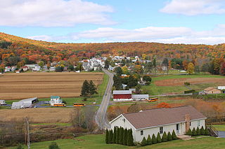
Drums is an unincorporated community in Butler Township, Luzerne County, Pennsylvania. Located about 1,500 feet (460 m) altitude in the Sugarloaf Valley, it is situated east of Interstate 81 and north of Nescopeck Creek, a tributary of the Susquehanna River. It was founded by the Drum family in the late 18th century and was originally known as Drum's. Its ZIP Code is 18222, served by the 788 exchange in Area Code 570.

References

  1. "ArcGIS REST Services Directory". United States Census Bureau. Retrieved October 12, 2022.
  2. 1 2 "Census Population API". United States Census Bureau. Retrieved Oct 12, 2022.
  3. 1 2 Bureau, US Census. "City and Town Population Totals: 2020—2021". Census.gov. US Census Bureau. Retrieved August 4, 2022.
  4. Hazleton Standard Speaker publication, Hazleton, Pa. Oct. 10, p.23
  5. Helman, Laura, "The History and Genealogy of the Drum Family", 1927, Press of Berkmeyer, Keck & Co. Allentown, Pa., P.23
  6. Hazleton Standard Speaker publication, Aug. 29, 1973
  7. The Conyngham Borough Centennial Committee, "A Centennial History of Conyngham Borough 1901-2001" , Citizen Publishing Co., Hazleton, Pa. 2001, p.95
  8. The Conyngham Borough Centennial Committee, "A Centennial History of Conyngham Borough 1901-2001, Citizen Publishing Company, Hazleton, Pa.2001, p.8
  9. Hazelton or Nesquehoning quadrangle made in 1893. See closeup of the 1893 topographic map on the Nesquehoning Creek page, and that of Old Lausanne Township.
  10. "US Gazetteer files: 2010, 2000, and 1990". United States Census Bureau. 2011-02-12. Retrieved 2011-04-23.
  11. "Census of Population and Housing". U.S. Census Bureau. Retrieved 11 December 2013.
  12. 1 2 "U.S. Census website". United States Census Bureau . Retrieved 2008-01-31.
  13. "Incorporated Places and Minor Civil Divisions Datasets: Subcounty Resident Population Estimates: April 1, 2010 to July 1, 2012". Population Estimates. U.S. Census Bureau. Archived from the original on 11 June 2013. Retrieved 11 December 2013.
  14. "Census of Population and Housing". Census.gov. Retrieved June 4, 2016.