Newport Township, Pennsylvania

Last updated

Newport Township, Pennsylvania
First Class Township
St Stan LuzCo PA 1.JPG
Map of Luzerne County, Pennsylvania Highlighting Newport Township.PNG
Map of Luzerne County highlighting Newport Township
Map of Pennsylvania highlighting Luzerne County.svg
Map of Pennsylvania highlighting Luzerne County
Country United States
State Pennsylvania
County Luzerne
Settled1772
Incorporated1790
Area
[1]
  Total17.19 sq mi (44.51 km2)
  Land16.76 sq mi (43.40 km2)
  Water0.43 sq mi (1.11 km2)
Population
 (2020) [2]
  Total4,444 Decrease2.svg
  Estimate 
(2021) [2]
4,453
  Density314.70/sq mi (121.51/km2)
Time zone UTC-5 (Eastern (EST))
  Summer (DST) UTC-4 (EDT)
FIPS code 42-079-53960
Website newporttownship.com

Newport Township is a township in Luzerne County, Pennsylvania, United States. As of 2020, the population was 4,444. [2] Newport is located on the outskirts of Nanticoke City.

Contents

History

Establishment

An old map of Newport Township OldmapNewportTwp..jpg
An old map of Newport Township

Newport was incorporated as a township in 1790. It is one of the original townships in Luzerne County. The municipality derives its name from Newport, Rhode Island. The first settlement in modern-day Newport Township was established by Major Prince Alden in 1772. A few years later, his sons (Mason and John) erected a forge on Nanticoke Creek. One of the first stores in the territory was established by Jacob Ramback; it was constructed on a road between Wanamie and Nanticoke. [3]

Due to the growing coal mining industry in the Wyoming Valley (in the 19th century), farmers were selling large tracts of land to the coal companies. Even sawmills and gristmills were replaced by coal mines. Alden, Glen Lyon, and Wanamie were just a few of the mining villages in the township. Mine shafts and collieries were constructed throughout the territory. [3]

Boom and bust

At the beginning of the 20th century, Luzerne County was in the midst of an economic boom. Industry, which included manufacturing and coal mining, drew thousands of immigrants (mostly from Europe) to the region. By the mid-20th century, anthracite production was declining at a fairly steady rate. Consumers were gradually switching from coal to other forms of energy (e.g., oil, gas, and electricity). [4] [5] [6]

The Knox Mine Disaster was the final blow to the industry. On January 22, 1959, the Susquehanna River broke through the River Slope Mine in Port Griffith, Jenkins Township. The incident claimed twelve lives. In the following months, two of the area's largest coal companies announced a full withdrawal from the anthracite business. Thousands of jobs were lost and the mining industry never recovered in Luzerne County. [7]

Contemporary history

St. Stanislaus Institute, also known as St. Stanislaus Orphanage and Holy Child Church, was built between 1918 and 1939. The facility served as a Catholic orphanage until it closed in 1972. St. Stanislaus was added to the National Register of Historic Places in 2008. [8] The building is now occupied by apartments. Holy Child closed in 2010. A nursing home was built nearby.

In 1986, State Correctional Institute at Retreat opened in northwestern Newport Township, replacing the mental hospital. SCI Retreat closed in June 2020. It was a medium security correctional facility for men.

Geography

The picnic area at St. Stanislaus Institute St Stan LuzCo PA 4.JPG
The picnic area at St. Stanislaus Institute
Fire station in Wanamie Fire station in Wanamie, Pennsylvania.jpg
Fire station in Wanamie
Houses in Glen Lyon Glen Lyon, Pennsylvania (8481309763).jpg
Houses in Glen Lyon

According to the United States Census Bureau, the township has a total area of 17.2 square miles (44.5 km2), of which 16.8 square miles (43.4 km2) is land and 0.42 square miles (1.1 km2), or 2.49%, is water. Most of the township is forested. It is drained by the Susquehanna River (which forms its northern boundary).

The northern and southern portions are mountainous. The elevation of Penobscot Mountain reaches 1,500 to 1,629 feet (457 to 497 m) above sea level along the township's southern border with Slocum Township. Most of the people live in the basin of Newport Creek, which flows northeast from Glen Lyon to the Susquehanna River (in Nanticoke). Newport Township consists of the communities of Alden Station, Glen Lyon, Lee, Newport Center, Sheatown, and Wanamie. The State Correctional Institute at Retreat is in a remote area of the municipality (along the Susquehanna River). The facility can only be accessed by a bridge over the river from U.S. Route 11 or by helicopter.

Neighboring municipalities

Government officials

Public safety

Demographics

Historical population
CensusPop.Note
2000 5,006
2010 5,3747.4%
2020 4,444−17.3%
2021 (est.)4,453 [2] 0.2%
U.S. Decennial Census [10]

As of the census [11] of 2000, there were 5,006 people, 1,789 households, and 1,118 families residing in the township. The population density was 306.1 inhabitants per square mile (118.2/km2). There were 2,166 housing units at an average density of 132.4 per square mile (51.1/km2). The racial makeup of the township was 90.17% White, 8.57% African American, 0.12% Native American, 0.30% Asian, 0.54% from other races, and 0.30% from two or more races. Hispanic or Latino of any race were 2.30% of the population.

There were 1,789 households, out of which 24.4% had children under the age of 18 living with them, 45.5% were married couples living together, 12.2% had a female householder with no husband present, and 37.5% were non-families. 32.5% of all households were made up of individuals, and 19.5% had someone living alone who was 65 years of age or older. The average household size was 2.27 and the average family size was 2.87.

In the township the population was spread out, with 16.1% under the age of 18, 10.2% from 18 to 24, 33.4% from 25 to 44, 21.5% from 45 to 64, and 18.7% who were 65 years of age or older. The median age was 38 years. For every 100 females, there were 127.8 males. For every 100 females age 18 and over, there were 129.6 males.

The median income for a household in the township was $32,073, and the median income for a family was $40,987. Males had a median income of $28,466 versus $22,035 for females. The per capita income for the township was $16,930. About 9.3% of families and 14.0% of the population were below the poverty line, including 24.4% of those under age 18 and 14.8% of those age 65 or over.

Notable people

Related Research Articles

<span class="mw-page-title-main">Luzerne County, Pennsylvania</span> County in Pennsylvania, United States

Luzerne County is a county in the Commonwealth of Pennsylvania. According to the United States Census Bureau, the county has a total area of 906 square miles (2,350 km2), of which 890 square miles (2,300 km2) is land and 16 square miles (41 km2) is water. It is Northeastern Pennsylvania's second-largest county by total area. As of the 2020 census, the population was 325,594, making it the most populous county in the northeastern part of the state. The county seat and most populous city is Wilkes-Barre. Other populous communities include Hazleton, Kingston, Nanticoke, and Pittston. Luzerne County is included in the Scranton–Wilkes-Barre–Hazleton Metropolitan Statistical Area, which has a total population of 555,426 as of 2017. The county is part of the Northeastern Pennsylvania region of the state.

<span class="mw-page-title-main">Glen Lyon, Pennsylvania</span> Census-designated place in Pennsylvania, United States

Glen Lyon is a census-designated place (CDP) in Newport Township, Pennsylvania, United States. The population was 1,877 at the 2020 census.

<span class="mw-page-title-main">Hanover Township, Luzerne County, Pennsylvania</span> Township in Pennsylvania, United States

Hanover Township is a township in Luzerne County, Pennsylvania. As of the 2020 census, the population was 11,424, making it the most populous township in the county.

<span class="mw-page-title-main">Hazle Township, Pennsylvania</span> Township in Pennsylvania, United States

Hazle Township is a township in Luzerne County, Pennsylvania, United States. The population was 10,150 at the time of the 2020 census. The township surrounds the city of Hazleton and the borough of West Hazleton.

<span class="mw-page-title-main">Hazleton, Pennsylvania</span> City in Pennsylvania, United States

Hazleton is a city in Luzerne County, Pennsylvania, United States. The population was 29,963 at the 2020 census. Hazleton is the second-most populous city in Luzerne County. It was incorporated as a borough on January 5, 1857, and as a city on December 4, 1891.

<span class="mw-page-title-main">Jenkins Township, Pennsylvania</span> Township in Pennsylvania, United States

Jenkins Township is a township in the Greater Pittston area of Luzerne County, Pennsylvania, United States. The population was 4,282 at the 2020 census.

<span class="mw-page-title-main">Nanticoke, Pennsylvania</span> City in Luzerne County, Pennsylvania, United States

Nanticoke is a city in Luzerne County, Pennsylvania, United States. As of the 2020 census, the population was 10,628, making it the third largest city in Luzerne County. It occupies 3.6 square miles (9.3 km2) of land. Nanticoke is part of Northeastern Pennsylvania.

<span class="mw-page-title-main">Pittston, Pennsylvania</span> City in Pennsylvania, United States

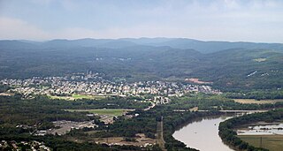
Pittston is a city in Luzerne County, Pennsylvania, United States. The city lies in the Wyoming Valley on the east side of the Susquehanna River and on the south side of the Lackawanna River. It is approximately midway between Wilkes-Barre and Scranton. Pittston is 68.7 miles (110.6 km) north of Allentown and 129.2 miles (207.9 km) northwest of New York City.

<span class="mw-page-title-main">Plains Township, Pennsylvania</span> Township in Pennsylvania, United States

Plains Township is a township in Luzerne County, Pennsylvania, United States. The population was 9,816 at the 2020 census. The municipality is the birthplace of Chicago White Sox hall of famer Ed Walsh and John J. Yeosock, a United States Army general who commanded the 3rd U.S. Army during Operation Desert Shield and Operation Desert Storm. Mohegan Pennsylvania is a casino in Plains Township.

<span class="mw-page-title-main">Plymouth Township, Luzerne County, Pennsylvania</span> Township in Pennsylvania, United States

Plymouth Township is located in Luzerne County, Pennsylvania, United States. The population was 1,712 at the 2020 census.

<span class="mw-page-title-main">Shickshinny, Pennsylvania</span> Borough in Pennsylvania, United States

Shickshinny is a borough in Luzerne County, Pennsylvania, United States. The population was 630 at the 2020 census.

<span class="mw-page-title-main">Slocum Township, Pennsylvania</span> Township in Pennsylvania, United States

Slocum Township is a township in Luzerne County, Pennsylvania, United States. The population was 1,053 at the 2020 census.

<span class="mw-page-title-main">Sugarloaf Township, Luzerne County, Pennsylvania</span> Township in Pennsylvania, United States

Sugarloaf Township is a township that is located in Luzerne County, Pennsylvania, United States. The population was 3,879 at the time of the 2020 census.

<span class="mw-page-title-main">White Haven, Pennsylvania</span> Borough in Pennsylvania, United States

White Haven is a borough in Luzerne County, Pennsylvania, United States. It is located along the Lehigh River. The population was 1,163 at the 2020 census.

<span class="mw-page-title-main">Kline Township, Schuylkill County, Pennsylvania</span> Township in Pennsylvania, United States

Kline Township is a township in Schuylkill County, Pennsylvania. The population was 1,473 at the 2020 census.

<span class="mw-page-title-main">Ashland, Pennsylvania</span> Borough in Pennsylvania, United States

Ashland is a borough in Schuylkill County in the U.S. state of Pennsylvania, 15 miles (24 km) northwest of Pottsville. It is part of Northeastern Pennsylvania. A small part of the borough also lies in Columbia County, although all of the population resided in the Schuylkill County portion as of the 2020 census. The borough lies in the anthracite coal region of eastern Pennsylvania. Settled in 1850, Ashland was incorporated in 1857, and was named for Henry Clay's estate near Lexington, Kentucky. The population in 1900 was 6,438, and in 1940, 7,045, but had dropped to 2,471 at the 2020 census.

<span class="mw-page-title-main">Wanamie, Pennsylvania</span> Census-designated place in Pennsylvania, United States

Wanamie is an unincorporated community and census-designated place in Newport Township, Luzerne County, Pennsylvania. It is located in the southwestern end of the Wyoming Valley and uses the Nanticoke zip code of 18634. The South Branch Newport Creek forms the natural eastern boundary of Wanamie and drains it northeastward via the Newport Creek into the Susquehanna River. The village is named after the Wanami tribe of the Lenni Lenape. As of the 2010 census, its population was 612.

Newport Creek is a tributary of the Susquehanna River in Luzerne County, Pennsylvania, in the United States. It is 4.9 miles (7.9 km) in length. Named tributaries of the creek include South Branch Newport Creek. The entire watershed of Newport Creek is considered by the Pennsylvania Department of Environmental Protection to be impaired.

Black Creek is a tributary of the Susquehanna River in Luzerne County, Pennsylvania, in the United States. It is approximately 2.6 miles (4.2 km) long and flows through Conyngham Township. The creek's watershed has an area of 3.85 square miles (10.0 km2). It is designated as a Coldwater Fishery and a Migratory Fishery. The creek is ephemeral and loses its flow to underground mines. Varying concentrations of many alkali metals, alkaline earth metals, and transition metals occur in water in the creek's watershed. The watershed typically experiences relatively mild temperatures. It is mainly accessible via U.S. Route 11, Pennsylvania Route 239, and a local road.

<span class="mw-page-title-main">Nanticoke Creek</span> River in the United States of America

Nanticoke Creek is a tributary of the Susquehanna River in Luzerne County, Pennsylvania, in the United States. It is approximately 4.4 miles (7.1 km) long and flows through Hanover Township and Nanticoke. The watershed of the creek has an area of 7.57 square miles (19.6 km2). The creek has one named tributary, which is known as Espy Run. Nanticoke Creek impaired by pH and metals due to abandoned mine drainage. Abandoned mine drainage discharges in the creek's watershed include the Truesdale Mine Discharge and the Askam Borehole. The creek is located in the Northern Middle Anthracite Field and is in the Anthracite Valley Section of the ridge and valley physiographic province. The main rock formations in the watershed include the Mauch Chunk Formation, the Pottsville Group, and the Llewellyn Formation. The surficial geology consists of coal dumps, surface mining land, alluvium, Wisconsinan Outwash, Wisconsinan Till, urban land, and bedrock.

References

  1. "2016 U.S. Gazetteer Files". United States Census Bureau. Retrieved August 14, 2017.
  2. 1 2 3 4 Bureau, US Census. "City and Town Population Totals: 2020—2021". Census.gov. US Census Bureau. Retrieved August 4, 2022.
  3. 1 2 "Newport Township".
  4. Healey, Richard (2005) "The Breakers of the Northern Anthracite Coalfield of Pennsylvania", 'Vol. 1, Major breakers prior to 1902'. Dept of Geography, University of Portsmouth, Portsmouth. quote="Northern Anthracite Coalfield of Pennsylvania" There also are Central and Southern Anthracite Coalfields of Pennsylvania, the one around Hazelton and the other around Pottsville.
  5. Sevon, W. D., compiler, 2000, "Physiographic provinces of Pennsylvania" , Pennsylvania Geological Survey of the Pennsylvania Department of Conservation and Natural Resources, Pennsylvania Geological Survey, 4th ser., Map 13, scale 1:2,000,000.
  6. "The Face of Decline: The Pennsylvania Anthracite Region in the Twentieth Century".
  7. Chris Murley (2005). "Knox Mine Disaster" . Retrieved December 29, 2016.
  8. "National Register Information System". National Register of Historic Places . National Park Service. March 13, 2009.
  9. "Officials". Archived from the original on March 1, 2019. Retrieved February 24, 2019.
  10. "Census of Population and Housing". Census.gov. Retrieved June 4, 2016.
  11. "U.S. Census website". United States Census Bureau . Retrieved January 31, 2008.

41°10′30″N75°59′58″W / 41.17500°N 75.99944°W / 41.17500; -75.99944