Janesville is an unincorporated community in Clearfield County, Pennsylvania, United States. The community is located at the intersection of state routes 253, 453 and 729, 2.9 miles (4.7 km) south-southwest of Ramey. Janesville has a post office with ZIP code 16680, which opened on February 25, 1826.
Gray is an unincorporated community in Somerset County, Pennsylvania, United States. The community is located along Pennsylvania Route 985 8.9 miles (14.3 km) north of Somerset. Gray has a post office with ZIP code 15544.
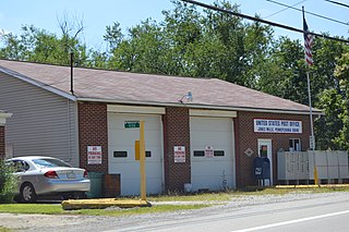
Listie is an unincorporated community in Somerset County, Pennsylvania, United States. The community is located 3.7 miles (6.0 km) east-northeast of Somerset. Listie had a post office until September 28, 2002; it still has its own ZIP code, 15549.
Boynton is an unincorporated community in Somerset County, Pennsylvania, United States. The community is located along the Casselman River and U.S. Route 219 1.2 miles (1.9 km) north-northeast of Salisbury. Boynton has a post office with ZIP code 15532.
Clearville is an unincorporated community in Bedford County, Pennsylvania, United States. The community is located along Pennsylvania Route 26 6.6 miles (10.6 km) south of Everett. Clearville has a post office with ZIP code 15535.
Fairbank is an unincorporated community in Fayette County, Pennsylvania, United States. The community is located 7.7 miles (12.4 km) west-northwest of Uniontown. Fairbank has a post office, with ZIP code 15435, which opened on July 30, 1906.
La Belle is an unincorporated community in Fayette County, Pennsylvania, United States. The community is located along the Monongahela River, 5.1 miles (8.2 km) west of Brownsville. La Belle has a post office, with ZIP code 15450.
Leisenring is an unincorporated community in Fayette County, Pennsylvania, United States. The community is located 3.2 miles (5.1 km) west-southwest of Connellsville. The Leisenring post office carries ZIP code 15455.
Uledi is an unincorporated community in Fayette County, Pennsylvania, United States. The community is located along Pennsylvania Route 21, 4 miles (6.4 km) west of Uniontown. Uledi has a post office, with ZIP code 15484, which opened on April 14, 1902.
West Leisenring is an unincorporated community in Fayette County, Pennsylvania, United States. The community is 4.2 miles (6.8 km) north of Uniontown. West Leisenring has a post office, with ZIP code 15489, which opened on December 27, 1882.
Jones Mills is an unincorporated community in Westmoreland County, Pennsylvania, United States. The community is located along Pennsylvania Routes 31 and 381, 2.8 miles (4.5 km) east-southeast of Donegal. Jones Mills has a post office with ZIP code 15646, which opened on May 23, 1850.
Madera is an unincorporated community in Clearfield County, Pennsylvania, United States. The community is located along Pennsylvania Route 53, 4.4 miles (7.1 km) west of Houtzdale. Madera has a post office with ZIP code 16661, which opened on January 31, 1861.
Morann is an unincorporated community in Clearfield County, Pennsylvania, United States. The community is located along Pennsylvania Route 153, 2.8 miles (4.5 km) south-southwest of Houtzdale. Morann has a post office with ZIP code 16663, which opened on June 19, 1890.
Saint Boniface is an unincorporated community in Cambria County, Pennsylvania, United States. The community is located along Pennsylvania Route 36, 1.7 miles (2.7 km) east of Hastings. Saint Boniface has a post office, with ZIP code 16675.
Smoke Run is an unincorporated community in Clearfield County, Pennsylvania, United States. The community is located along Pennsylvania Route 453, 1.6 miles (2.6 km) west of Ramey. Smoke Run has a post office with ZIP code 16681.
Wood is an unincorporated community in the U.S. state of Pennsylvania; portions of the community lie in Bedford, Fulton, and Huntingdon counties. The community is 2.4 miles (3.9 km) south of Broad Top City. Wood has a post office with ZIP code 16694, which opened on September 9, 1908.
Drifting is an unincorporated community in Clearfield County, Pennsylvania, United States. The community is located along Pennsylvania Route 53, 8.3 miles (13.4 km) west of Snow Shoe. Drifting has a post office with ZIP code 16834, which opened on December 6, 1895.
Zullinger is an unincorporated community in Franklin County, Pennsylvania, United States. The community is located along Pennsylvania Route 16 2.9 miles (4.7 km) west-northwest of Waynesboro. Zullinger has a post office with ZIP code 17272.
Lehman is an unincorporated community in Lehman Township, Luzerne County, Pennsylvania, United States. The community is located along Pennsylvania Route 118, 3.4 miles (5.5 km) west-southwest of Dallas. Lehman has a post office with ZIP code 18627, which opened on January 18, 1826.
Lawton is an unincorporated community in Susquehanna County, Pennsylvania, United States. The community is located along Pennsylvania Route 267, Pennsylvania Route 367, and Pennsylvania Route 706, 10.5 miles (16.9 km) west-southwest of Montrose. Lawton has a post office with ZIP code 18828.

