Rockwood, Pennsylvania

Last updated
Rockwood, Pennsylvania
previously Mineral Point (c. 1857)
Borough
Rockwood, Pennsylvania Somerset County.jpg
View down Bridge St.
Somerset County Pennsylvania Incorporated and Unincorporated areas Rockwood Highlighted.svg
Location of Rockwood in Somerset County, Pennsylvania.
USA Pennsylvania location map.svg
Red pog.svg
Coordinates: 39°54′58″N79°09′21″W / 39.91611°N 79.15583°W / 39.91611; -79.15583
Country United States
State Pennsylvania
County Somerset
Settled1857
Incorporated1885
Government
  TypeBorough Council
Area
[1]
  Total0.33 sq mi (0.87 km2)
  Land0.33 sq mi (0.87 km2)
  Water0.00 sq mi (0.00 km2)
Elevation
1,837 ft (560 m)
Population
 (2020) [2]
  Total843
  Density2,523.95/sq mi (974.27/km2)
Time zone UTC-5 (Eastern (EST))
  Summer (DST) UTC-4 (EDT)
Zip code
15557
Area code 814
FIPS code 42-65736

Rockwood is a borough in Somerset County, Pennsylvania, United States. The population was 850 at the 2020 census. [3] It is part of the Johnstown, Pennsylvania, Metropolitan Statistical Area, and located due north of Pennsylvania's highest peak, Mount Davis, which significantly constricts land travel routing south of the municipality.

Contents

History

Mineral Point, Somerset County, Pennsylvania, 1860 Map of Mineral Point, Pennsylvania, from 1860 Somerset County Map by Edward L Walker.jpg
Mineral Point, Somerset County, Pennsylvania, 1860
Construction of Casselman River Bridge, Rockwood, PA, circa 1914 Casselman River Bridge Construction Rockwood Pennsylvania from Baltimore & Ohio Employes Magazine June 1914 Vol 2 No 09 Page 06.jpg
Construction of Casselman River Bridge, Rockwood, PA, circa 1914

Rockwood was initially known as Shaff's Bridge and then Mineral Point. [4] Philip Wolfersberger built a house in what is now Rockwood in 1856, and he laid out the town in 1857 with Martin Meyers serving as the primary surveyor. [4] John Poister built a hotel in 1860. [4] 1868 saw the development of a post office, Henry Werner built a tannery in 1869, and a railroad depot was built in 1871. [4] J.D. Miller and E.D. Miller opened a mercantile, Miller & Bro., and in 1874 they expanded the business to take in Samuel A. Haines as a partner, forming Miller Bros. & Haines. [5]

Philip Stauffer Wolfersberger, a son of the above Philip Wolfersberger, was a ticket agent of the Baltimore & Ohio Railroad (B&O) and was instrumental in getting the current name of Rockwood to take hold. [4] A view of Mineral Point / Rockwood appeared in a collection of photographs from along the B&O's lines that was published in book form in 1872 and digitized by the DeGolyer Library, Southern Methodist University. [6]

A collision between two trains on the Pittsburgh & Connellsville Railroad, occurring about three miles east of Rockwood, claimed six lives in November 1894. [7] Eleven individuals were injured when two trains collided on the P&C line just outside of Rockwood on Dec. 29, 1898. [8] Another collision between two trains near Rockwood injured 24 people on February 16, 1912. [9]

The B&O Railroad was a major east-west transportation artery in the region, with many people using it to pass over the Appalachian Mountains. One exciting event occurred in 1907, when President Theodore Roosevelt made a brief stop in Rockwood during his trip to Ohio to attend the funeral of Ida McKinley, the wife of former U.S. President William McKinley. [10] As the Rockwood community grew and prospered, the bustling town became the home of numerous Christian congregations. As of 1914, at least five denominations had churches in Rockwood and the immediate vicinity: Lutheran, Methodist, Reformed, United Brethren, and United Evangelical. [11]

The Baltimore & Ohio Railroad passes through Rockwood as it bends northerly in a long bow about the roots of Mount Davis, and it is now owned and operated by CSX, with daily Amtrak express trains between Pittsburgh and Cumberland, MD passing through the town and the nearby Cumberland Narrows. It is situated near and below the West slope-side summit-point of both the Nemacolin Trail and Braddock's Road, as well as the railway as each ascended past the crest up through the Cumberland Narrows pass from the forks of the Potomac at Harper's Ferry. The town was thus an important stop over point in the post-American Revolution westward migration into the Ohio Country and via the river boats built in Brownsville. The Penrose Wolf Building was added to the National Register of Historic Places in 2002. [12]

Somerset & Mineral Point Railroad / Somerset & Cambria Branch / Rockwood & Johnstown Line

Rockwood, Somerset County, Pennsylvania, 1915 Map of Rockwood, Pennsylvania, area from 1915 Somerset County Public Road Map by Ralph C Benedict and Gustave P Strum.jpg
Rockwood, Somerset County, Pennsylvania, 1915

The Somerset & Mineral Point Railroad connected the town of Somerset with the Pittsburgh & Connellsville Railroad (owned by the B&O) as it passed through Mineral Point / Rockwood. [13] (The Somerset & Mineral Point Railroad is labelled as the Rockwood & Johnstown Line on the accompanying section of Benedict & Strum's 1915 Somerset County public road map). Both the Somerset & Mineral Point Railroad and the Pittsburgh & Connellsville Railroad were completed in 1871; [14] the final section of the line between Pittsburgh & Cumberland was completed on the afternoon of April 10, 1871, [15] with the final rail being laid near Forge Bridge, about 3 miles to the west of Mineral Point. [13] [16] There were eight stations located along the Somerset & Mineral Point line as it ran northeast along Coxes Creek: Mineral Point, Sames, Baker's, Milford, Mud Pike Crossing, Roberts, Cantner, and Somerset. [17] Two individuals who were involved in the founding of Ursina, which had its own small branch railroad further south in Somerset County, were officers of the Somerset & Mineral Point Railroad in 1873: William J. Baer was President and H.L. Baer was Secretary. [18] The B&O bought the 10-mile Somerset & Mineral Point Railroad in 1879 for $60,000, knowing that an extension of the line to Johnstown, Pennsylvania, in Cambria County, was quite possible; [19] this extension had already received legislative approval with session law no. 321 on Aug. 12, 1873. [20] The Johnstown & Somerset Railroad followed the Stonycreek valley north-by-northeast from Somerset through Stoystown to Johnstown; [13] it was built in 1881. [14] The result was a rail line known as the Somerset & Cambria Branch Railroad stretching between the Pittsburgh & Connellsville Railroad at Rockwood and the Pennsylvania Railroad at Johnstown. [13] The Somerset & Cambria Branch later became known as the S&C Subdivision.

Company Branch Railroad Lines

In 1891 the Somerset Stone Company built a branch line from the Somerset & Cambria railroad's station at Milford east to its operation at Bare Rocks, [21] and the Bare Rock Rail Road Company was incorporated by John Murdock, J.M. Murdock, W.F. Murdock, J.C. Duncan, Samuel Fox, Josiah Woy, E.B. McColly, and S.F. Gill in 1892. [22] This connecting Milford Station was also known as Woy Station, where Harry Neff was the telegraph operator and Jacob Neff was the engineer of the Bare Rock line in 1893. [23] A tragic accident occurred along this company line on the evening of April 25, 1893, killing several people. [24] [25] In 1900 the Wilson Creek Coal Company constructed another branch railroad off of the Somerset & Cambria; this company line ran from about one mile north of Rockwood to its mining property about three miles to the east, following the course of Wilson Creek. [26] [27]

Geography

Rockwood is located at 39°54′58″N79°9′21″W / 39.91611°N 79.15583°W / 39.91611; -79.15583 (39.916222, -79.155808). [28] It is situated near and below the west-side crest of the Eastern Continental Divide separating the Potomac-Mississippi riverine systems along the north bank of the Casselman River whose head waters are to the south in nearby Western Maryland and just west of its confluence with Coxes Creek.

According to the United States Census Bureau, the borough has a total area of 0.3 square miles (0.78 km2), all land.

Demographics

Historical population
CensusPop.Note
1880 331
1890 55367.1%
1900 68523.9%
1910 1,30089.8%
1920 1,3624.8%
1930 1,176−13.7%
1940 1,37516.9%
1950 1,237−10.0%
1960 1,101−11.0%
1970 1,051−4.5%
1980 1,0580.7%
1990 1,014−4.2%
2000 954−5.9%
2010 890−6.7%
2020 850−4.5%
2021 (est.)842 [3] −0.9%
Sources: [29] [30] [31]

As of the census [30] of 2000, there were 954 people, 406 households, and 272 families residing in the borough. The population density was 3,053.4 inhabitants per square mile (1,178.9/km2). There were 421 housing units at an average density of 1,347.4 per square mile (520.2/km2). The racial makeup of the borough was 99.58% White, 0.10% Native American, 0.10% Asian, and 0.21% from two or more races.

There were 406 households, out of which 29.8% had children under the age of 18 living with them, 51.2% were married couples living together, 11.6% had a female householder with no husband present, and 33.0% were non-families. 29.1% of all households were made up of individuals, and 11.8% had someone living alone who was 65 years of age or older. The average household size was 2.28 and the average family size was 2.79.

In the borough the population was spread out, with 22.0% under the age of 18, 8.4% from 18 to 24, 27.7% from 25 to 44, 23.8% from 45 to 64, and 18.1% who were 65 years of age or older. The median age was 39 years. For every 100 females there were 92.3 males. For every 100 females age 18 and over, there were 92.7 males.

The median income for a household in the borough was $25,139, and the median income for a family was $31,023. Males had a median income of $26,500 versus $20,066 for females. The per capita income for the borough was $13,687. About 12.3% of families and 15.1% of the population were below the poverty line, including 13.7% of those under age 18 and 9.3% of those age 65 or over.

Schools

The borough of Rockwood is served by the Rockwood Area School District, which includes Rockwood Area Elementary School and Rockwood Area Junior/Senior High School. Both schools are located along the borough's boundary with Milford Township. A second elementary school within the district was the Kingwood Elementary School, which was not within the borough of Rockwood. Kingwood Elementary School is now closed, and the building was sold to the Kingwood Church of God.

Typically, Rockwood Area High School graduates 65-80 students per year. [32]

Transportation

Pennsylvania Route 653 runs through Rockwood. It comes southeast from New Centerville through part of Milford Township, entering Rockwood as Bridge Street. PA 653 then turns east onto Main Street, which it follows through the borough and out of town, entering Milford Township again briefly before crossing Coxes Creek and entering Black Township. The nearest limited-access highway is the Pennsylvania Turnpike at Somerset (Exit 110), 10 miles (16 km) to the north.

Up until April 30, 1971, Rockwood was a stop on the Baltimore & Ohio's daily WashingtonAkron passenger train. Since 1981 Amtrak's Capitol Limited (ChicagoWashington) has passed through Rockwood without stopping. Since 1990 local officials have lobbied for Rockwood to be added as a stop, and in October 2009 Amtrak released a feasibility study which placed the cost of a new station at $2.2 million. [33] [34] Proponents of the stop suggest that it might even benefit local resorts Seven Springs and Hidden Valley by increasing tourism business throughout the area. [35]

Related Research Articles

<span class="mw-page-title-main">Somerset County, Pennsylvania</span> County in Pennsylvania, United States

Somerset County is a county in the Commonwealth of Pennsylvania. As of the 2020 census, the population was 74,129. Its county seat is Somerset. The county was created from part of Bedford County on April 17, 1795, and named after the county of Somerset in England.

<span class="mw-page-title-main">Cambria County, Pennsylvania</span> County in Pennsylvania, United States

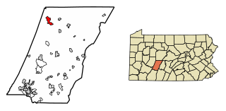
Cambria County is a county in the Commonwealth of Pennsylvania. As of the 2020 census, the population was 133,472. Its county seat is Ebensburg. The county was created on March 26, 1804, from parts of Bedford, Huntingdon, and Somerset counties and later organized in 1807. It was named for the nation of Wales, which in Latin is known as "Cambria".

<span class="mw-page-title-main">Cassandra, Pennsylvania</span> Borough in Pennsylvania, United States

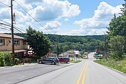
Cassandra is a borough in Cambria County, Pennsylvania, United States. The population was 147 at the 2010 census. It is part of the Johnstown, Pennsylvania Metropolitan Statistical Area.

<span class="mw-page-title-main">Cresson, Pennsylvania</span> Borough in Pennsylvania, United States

Cresson is a borough in Cambria County, Pennsylvania, United States. Cresson is 80 miles (130 km) east of Pittsburgh. It is above 2,000 feet (600 m) in elevation. Lumber, coal, and coke yards were industries that had supported the population, which numbered 1,470 in 1910. The borough is part of the Johnstown Metropolitan Statistical Area, although state and local sources list it as part of the Altoona area due to being much closer to that city. The population of Cresson at the 2010 census was 1,711.

<span class="mw-page-title-main">Ebensburg, Pennsylvania</span> Borough in Pennsylvania, United States

Ebensburg is a borough and the county seat of Cambria County in the U.S. state of Pennsylvania. It is located 25 miles (40 km) west of Altoona and surrounded by Cambria Township. It is situated in the Allegheny Mountains at about 2,140 feet (650 m) above sea level. Ebensburg is located in a rich bituminous coal region. In the past, sawmills, tanneries, wool mills, and a foundry operated there. The number of residents in 1900 was 1,574, and in 1910, 1,978. The population was 3,351 at the 2010 census. It is part of the Johnstown, Pennsylvania Metropolitan Statistical Area.

<span class="mw-page-title-main">Ferndale, Pennsylvania</span> Borough in Pennsylvania, United States

Ferndale is a borough in Cambria County, Pennsylvania, United States. It is part of the Johnstown, Pennsylvania Metropolitan Statistical Area. The population was 1,636 at the 2010 census, down from 1,834 at the 2000 census.

<span class="mw-page-title-main">Johnstown, Pennsylvania</span> City in Pennsylvania, United States

Johnstown is the largest city in Cambria County, Pennsylvania, United States. The population was 18,411 as of the 2020 census. Located 57 miles (92 km) east of Pittsburgh, it is the principal city of the Johnstown metropolitan area, which is located in Cambria County and had 133,472 residents in 2020. It is also part of the Johnstown–Somerset combined statistical area, which includes both Cambria and Somerset Counties.

<span class="mw-page-title-main">Northern Cambria, Pennsylvania</span> Borough in Pennsylvania, United States

Northern Cambria is a borough in Cambria County, Pennsylvania, United States. It is part of the Johnstown, Pennsylvania Metropolitan Statistical Area. The population was 3,835 at the 2010 census.

<span class="mw-page-title-main">Portage Township, Cambria County, Pennsylvania</span> Township in Pennsylvania, United States

Portage Township is a township in Cambria County, Pennsylvania, United States. It surrounds the borough of Portage. The township population was 3,640 at the 2010 census. It is part of the Johnstown, Pennsylvania Metropolitan Statistical Area.

<span class="mw-page-title-main">Richland Township, Cambria County, Pennsylvania</span> Township in Pennsylvania, United States

Richland Township is a township in Cambria County, Pennsylvania, United States. The population was 12,814 at the 2010 census. It is part of the Johnstown, Pennsylvania Metropolitan Statistical Area.

<span class="mw-page-title-main">Connellsville, Pennsylvania</span> City in Pennsylvania, United States

Connellsville is a city in Fayette County, Pennsylvania, United States, 36 miles (58 km) southeast of Pittsburgh and 50 miles (80 km) away via the Youghiogheny River, a tributary of the Monongahela River. It is part of the Pittsburgh metropolitan area. The population was 7,031 at the 2020 census.

<span class="mw-page-title-main">Black Township, Pennsylvania</span> Township in Pennsylvania, United States

Black Township is a township in Somerset County, Pennsylvania, United States. The population was 899 at the 2020 census. It is part of the Johnstown, Pennsylvania, Metropolitan Statistical Area. The township was named for Jeremiah Sullivan Black, a native of Somerset County who became Chief Justice of the Supreme Court of Pennsylvania, U.S. Attorney General, and U.S Secretary of State.

<span class="mw-page-title-main">Casselman, Pennsylvania</span> Borough in Pennsylvania, United States

Casselman is a borough in Somerset County, Pennsylvania, United States.

<span class="mw-page-title-main">Garrett, Pennsylvania</span> Borough in Pennsylvania, United States

Garrett is a borough in Somerset County, Pennsylvania, United States. It is part of the Johnstown, Pennsylvania, Metropolitan Statistical Area. The population was 416 at the 2020 census.

<span class="mw-page-title-main">Milford Township, Somerset County, Pennsylvania</span> Township in Pennsylvania, United States

Milford Township is a township in Somerset County, Pennsylvania, United States. The population was 1,488 at the 2020 census. It is part of the Johnstown, Pennsylvania, Metropolitan Statistical Area.

<span class="mw-page-title-main">New Centerville, Pennsylvania</span> Borough in Pennsylvania, United States

New Centerville is a borough in Somerset County, Pennsylvania, United States. The population was 127 at the 2020 census. It is part of the Johnstown, Pennsylvania, Metropolitan Statistical Area. It should not be confused with the unincorporated village of New Centerville in Tredyffrin Township.

<span class="mw-page-title-main">Seven Springs, Pennsylvania</span> Borough in Pennsylvania, United States

Seven Springs is a borough in Somerset and Fayette counties in the U.S. state of Pennsylvania. The Fayette County portion of the borough and resort are part of the Pittsburgh metropolitan area, and the Somerset County portion is part of the Johnstown Metropolitan Area. The population of the borough was 26 as of the 2010 census, compared to 127 at the 2000 census. Fifteen of the residents in 2010 were in Fayette County, and 11 in Somerset County.


The Keystone Subdivision is a railroad line owned and operated by CSX Transportation in the U.S. states of Maryland and Pennsylvania. The line runs from Cumberland, Maryland, west to McKeesport, Pennsylvania, along a former Baltimore and Ohio Railroad (B&O) line. The line includes the well-known Sand Patch Grade over the Allegheny Mountains.

The S&C Subdivision is a railroad line owned and operated by CSX Transportation in the U.S. state of Pennsylvania. The line runs from the Keystone Subdivision at Rockwood north to Johnstown along a former Baltimore and Ohio Railroad line, once the Somerset and Cambria Railroad.

<span class="mw-page-title-main">Pennsylvania Route 271</span> State highway in Pennsylvania, US

Pennsylvania Route 271 is a north–south state route located in Western Pennsylvania. Its southern terminus is at PA 711 in Oak Grove in Ligonier Township, and its northern terminus is at U.S. Route 219 (US 219) in Northern Cambria. The route was designated on May 27, 1935 in coordination with the release of a new state road map.

References

  1. "ArcGIS REST Services Directory". United States Census Bureau. Retrieved August 8, 2023.
  2. "Census Population API". United States Census Bureau. Retrieved Oct 12, 2022.
  3. 1 2 Bureau, US Census. "City and Town Population Totals: 2020—2021". Census.gov. US Census Bureau. Retrieved July 25, 2022.
  4. 1 2 3 4 5 History of Bedford, Somerset and Fulton Counties, Pennsylvania. Chicago: Waterman, Watkins & Co. 1884. p. 542.
  5. "Copartnership Notice" (PDF). Somerset Herald. 1 April 1874. Retrieved 21 October 2023.
  6. Photographic Views of the Baltimore and Ohio Rail Road and Its Branches, From the Lakes to the Sea. First Series. Baltimore: Cushings & Bailey. 1872.
  7. "A Terrible Collision" (PDF). Somerset Herald. 14 November 1894. Retrieved 17 October 2020.
  8. "Eleven Hurt in a Wreck". New York Times . 30 December 1898. Retrieved 28 October 2023.
  9. "24 Hurt in B&O Wreck". New York Times . 17 February 1912. Retrieved 28 October 2023.
  10. "President Roosevelt in Rockwood" (PDF). Somerset County Star. 13 June 1907. Retrieved 21 October 2023.
  11. "Sunday School Convention" (PDF). Meyersdale Commercial. 27 August 1914. Retrieved 16 October 2023.
  12. "National Register Information System". National Register of Historic Places . National Park Service. July 9, 2010.
  13. 1 2 3 4 History of Bedford, Somerset and Fulton Counties, Pennsylvania. Chicago: Waterman, Watkins & Co. 1884. p. 180.
  14. 1 2 Treese, Lorett (2004). Somerset Historical Center: Pennsylvania Trail of History Guide. Mechanicsburg, PA: Stackpole Books. p. 15.
  15. Baer, Christopher T. "A General Chronology of the Pennsylvania Railroad Company, Its Predecessors and Successors, and Its Historical Context: 1871" (PDF). Pennsylvania Railroad Technical & Historical Society. Retrieved January 23, 2021.
  16. "Pittsburgh Secures Direct Railroad Communication with Baltimore" (PDF). Chicago Tribune . April 11, 1871. Retrieved October 16, 2020.
  17. Platt & Platt, Franklin & W.G. (1877). Report of Progress in the Cambria and Somerset District of the Bituminous Coal-Fields of Western Pennsylvania. Part II: Somerset. Harrisburg, PA: Board of Commissioners, Second Geological Survey of Pennsylvania. p. xvi.
  18. Poor, Henry V. (1873). Manual of the Railroads of the United States for 1873-74. New York: H.V. & H.W. Poor. p. 506.
  19. "Baltimore & Ohio". Commercial & Financial Chronicle, Vol. 29, No. 741. September 6, 1879. Retrieved May 17, 2020.
  20. Constitution of the Commonwealth of Pennsylvania: Also Laws of the General Assembly of Said Commonwealth Passed at the Session of 1874, in the Ninety-Eighth Year of Independence. Harrisburg, PA: Benjamin Singerly. 1874. pp. 432–433.
  21. "Thinks the Boom Is Booming" (PDF). Somerset Herald. 10 June 1891. Retrieved 18 October 2020.
  22. "[Messrs. John, J.M. and W.F. Murdock]" (PDF). Somerset County Star. 1 December 1892. Retrieved 29 October 2023.
  23. "[The officials of the B&O]" (PDF). Somerset County Star. 12 January 1893. Retrieved 29 October 2023.
  24. "Frightful Accident" (PDF). Somerset Herald. 26 April 1893. Retrieved 18 October 2020.
  25. "Horrible Railroad Wreck Near Somerset" (PDF). Somerset County Star. 27 April 1893. Retrieved 30 October 2023.
  26. "A Charter Was Granted" (PDF). Somerset Herald. 30 May 1900. Retrieved 17 October 2020.
  27. "A Few from the Somerset Standard" (PDF). Somerset County Star. 6 September 1900. Retrieved 29 October 2023.
  28. "US Gazetteer files: 2010, 2000, and 1990". United States Census Bureau. 2011-02-12. Retrieved 2011-04-23.
  29. "Census of Population and Housing". U.S. Census Bureau. Retrieved 11 December 2013.
  30. 1 2 "U.S. Census website". United States Census Bureau . Retrieved 2008-01-31.
  31. "Incorporated Places and Minor Civil Divisions Datasets: Subcounty Resident Population Estimates: April 1, 2010 to July 1, 2012". Population Estimates. U.S. Census Bureau. Archived from the original on 11 June 2013. Retrieved 11 December 2013.
  32. Public Schools Report
  33. Rock, Vicki (June 24, 2008). "Chamber lobbies for Rockwood Amtrak stop". Daily American . Retrieved 2009-12-18.[ permanent dead link ]
  34. Amtrak (October 16, 2009). "P.R.I.I.A. Section 224: Pennsylvania Feasibility: Studies Report" (PDF). Retrieved 2009-12-18.
  35. O’Reilly, Russ (Aug 15, 2010). "Rockwood Amtrak Stop Studied". The Tribune-Democrat . Retrieved June 6, 2020.