U.S. Route 40 in Pennsylvania

Last updated

US 40.svg

U.S. Route 40

National Road
U.S. Route 40 in Pennsylvania
US 40 highlighted in red and business routes in blue
Route information
Maintained by PennDOT
Length82.5 mi [1]  (132.8 km)
Tourist
routes
MUTCD M10-1.svg Historic National Road
Major junctions
West endUS 40.svg US 40 near Valley Grove, WV
Major intersections
East endUS 40.svg US 40 near Grantsville, MD
Location
Country United States
State Pennsylvania
Counties Washington, Fayette, Somerset
Highway system
PA-39.svg PA 39 PA-41.svg PA 41
US 11.svg US 11 PA 11PA-12.svg PA 12
I-81.svg I-81 PA 81I-81E.svg I-81E

U.S. Route 40 (US 40) enters Pennsylvania at West Alexander. It closely parallels Interstate 70 (I-70) from West Virginia until it reaches Washington, where it follows Jefferson Avenue and Maiden Street. In Washington, US 40 passes to the south of Washington & Jefferson College. Following Maiden Street out of town, the road turns southeast toward the town of California. A short limited access highway in California and West Brownsville provides an approach to the Lane Bane Bridge across the Monongahela River. From here, the road continues southeast to Uniontown.

Contents

US 40 bypasses Uniontown along a freeway that also carries US 119. An old alignment through Uniontown is signed as US 40 Business. Southeast of Uniontown, travellers pass the Fort Necessity National Battlefield. It follows Braddock Road southeast of Uniontown, crossing the Youghiogheny River Lake on a bridge completed in 2006. US 40 leaves Pennsylvania at Addison.

Route description

US 40 westbound in Addison Township 2022-05-14 07 56 52 View west along U.S. Route 40 (National Pike) at Main Street in Addison Township, Somerset County, Pennsylvania.jpg
US 40 westbound in Addison Township

U.S. Route 40 enters Pennsylvania in rural western Washington County near West Alexander. It travels to the east-northeast paralleling I-70 through Claysville on to Washington. While in Washington, the largest city on U.S. 40 in Pennsylvania, it is named Chestnut St. Exit 15 on I-70 is signed for Chestnut St. Route 40 leaves Chestnut St. and joins PA 18 becoming Jefferson Ave. After two blocks of concurrency with PA 18, it leaves PA 18 and joins US 19. US 40/US 19 then leaves Washington as Maiden St. US 19 leaves Route 40 in Laboratory before it intersects I-79 at exit 33. Now heading east-southeast, US 40 makes its way toward Brownsville. Route 40 passes through Scenery Hill and Beallsville before reaching PA 43/PA 88 at a full cloverleaf interchange in Centerville. US 40 then crosses the Monongahela River via the Lane Bane Bridge leaving Washington County after spending nearly 40 miles (64 km) in the county. [2]

US 40 enters Fayette County as Market St. in Brownsville. After leaving Brownsville, Route 40 heads to the southeast toward Uniontown. The highway enters Uniontown as Main St. in front of the Uniontown Mall. When it reaches US 119 it merges with it becoming a bypass of Uniontown. However, US 40 Business passes through downtown Uniontown as the one-way pair of Main St. and Fayette St. US 40 travels around the south of Uniontown and meets again with US 40 Business in Hopwood after leaving US 119. Route 40 then begins a steep ascent up Chestnut Ridge, the westernmost ridge of the Allegheny Mountains. US 40 becomes a treacherous mountain highway for the next 5 miles (8 KM) featuring steep descents and sharp curves. After passing through Chalk Hill, the National Road passes Fort Necessity National Battlefield and continues to Farmington. On the east side of Farmington, the highway passes Nemacolin Woodlands Resort. Heritage Reservation, a summer residence camp for the Boy Scouts of America is also accessible from this part of US 40, via Dinner Bell Five Forks Road. The National Pike then continues southeast toward the Maryland border after crossing the Youghiogheny River and entering Somerset County. Before leaving Pennsylvania, Route 40 passes through Addison. U.S. Route 40 spends 36.5 miles (58.7 km) in Fayette County and 6.1 miles (9.8 km) in Somerset County, passing through its southwestern corner. It enters Maryland in Garrett County. [3]

History

1789 to 1860

Envisioned by George Washington, US 40, or the National Road was built to connect the East and West. Needed by farmers and emigrants alike, the National Road would provide a stable route for trade through the Allegheny Mountains. [4] The National Road was preceded by buffalo trails, Native American footpaths, and the Nemacolin Trail. After the Revolutionary War, and an increase in migration westward, the newly formed national government realized that communication with the west would be difficult with the Appalachian Mountains separating the east coast from the western frontier. Therefore, the highway was put into Ohio's statehood bill by Albert Gallatin in 1802. [5]

In 1806, Thomas Jefferson authorized the construction of the Cumberland Road—the first federally funded highway in American history. Construction began in 1811 in Cumberland, Maryland and was completed to Wheeling, Virginia (present-day West Virginia) in 1820. In the 1830s, possession of the highway was turned over to the states through which it passes, which allowed states to collect tolls. The Commonwealth of Pennsylvania constructed six tollhouses along its 90milesegment of the highway. Two of these still stand: the Petersburg Tollhouse in Addison and the Searights Tollhouse in Fayette County. The Petersburg Tollhouse is the last remaining tollhouse constructed of native-cut stone in the United States. [6] [7] The westernmost toll house near West Alexander, PA has been demolished. Mile markers were also placed along the route. Made of cast-iron, these obelisk markers were placed every one mile and noted the distance to Cumberland and Wheeling and nearby towns. All of these markers are present today, though not all are the originals. Also in the 1830s, the Pony Express utilized the National Road. The 1840s marked the peak of the National Road. Used by many important figures including presidents, future presidents, and other notables, local businesses saw booming success along the road. This time period gave the National Road its nickname of the nation's "Main Street". The navigation of the Monongahela River after the construction of several locks and dams gave the National Road access to Pittsburgh via Brownsville. The Baltimore and Ohio Railroad also arrived in Cumberland in the 1840s. This allowed travel from the east coast to Cumberland via train, from Cumberland to Brownsville via stage coach, and then from Brownsville to Pittsburgh via steamboat. In the 1850s, railroads made it to the west causing the demise of the National Road. [5]

1860 to present

In the 1860s, the National Road became insignificant due to the use of the railroads. Many businesses along the route became private homes and the stage coach line went out of business. States relinquished responsibility of the highway to the counties so little or no maintenance was performed on the road. The 1880s brought a small revival to the National Road with the formation of the Good Roads Movement. The invention of the automobile would truly revitalize the highway. Touring along the National Road was popular and many of the businesses returned to offer services to this new type of consumer. The Post Office Appropriation Act of 1912 and the Rural Road Act of 1916 provided funds to rebuild the National Road, and World War I and the overburdened railroads made national highways a priority in the early twentieth century. In 1921, the National Road became U.S. Route 40 after the National Highway Act. The Pennsylvania Route 11 designation was also given to the National Road through Pennsylvania, eventually becoming Pennsylvania Route 81 before the road became solely US 40. The road became very popular again in the 1940s, but this only lasted until the 1950s when the Interstate Highway System was put into place. Today, US 40 has been replaced significantly by Interstate 70 and Interstate 68. US 40 is still used as a local road and scenic route in Pennsylvania, however. US 40 in Pennsylvania has been designated an All American Road (June 13, 2002), a Pennsylvania State Scenic Byway (July 11, 1996), and the Pennsylvania Heritage Corridor (May, 1994). [4] [5]

Major intersections

CountyLocationmi [1] kmExitDestinationsNotes
Washington Donegal Township 0.00.0West plate.svg
US 40.svg
US 40 west (National Road) Wheeling
Continuation into West Virginia
Claysville 6.310.1South plate.svg
PA-231.svg
PA 231 south (Bell Avenue)
Western terminus of PA 231 concurrency
6.510.5North plate.svg
PA-231.svg
PA 231 north (Wayne Street)
Eastern terminus of PA 231 concurrency
Buffalo Township 10.316.6PA-221.svg PA 221 (Green Valley Road/Bridge Road) Taylorstown, Prosperity
North Franklin Township 14.723.7I-70.svg I-70  New Stanton, Wheeling Partial cloverleaf interchange; exit 15 (I-70)
Washington 16.226.1North plate.svg
PA-18.svg
PA 18 north (Jefferson Avenue)
Western terminus of PA 18 concurrency
16.426.4East plate.svg
PA-136.svg
PA 136 east (Beau Street)
Western terminus of PA 136
16.827.0South plate.svg
PA-18.svg
PA 18 south (Main Street)
Eastern terminus of PA 18 concurrency
16.927.2North plate.svg
US 19.svg
US 19 north (College Street)
Western terminus of US 19 concurrency
South Strabane Township 18.930.4South plate.svg
US 19.svg
US 19 south (Waynesburg Road)
Eastern terminus of US 19 concurrency
Amwell Township 19.431.2I-79.svg I-79  Washington, Waynesburg Partial cloverleaf interchange; exit 33 (I-79)
North Bethlehem Township 23.537.8North plate.svg
PA-519.svg
PA 519 north Canonsburg
Southern terminus of PA 519
27.343.9North plate.svg
PA-917.svg
PA 917 north Cokeburg, Bentleyville
Southern terminus of PA 917
Centerville 34.956.2North plate.svg
PA-481.svg
PA 481 north (Old National Pike) Monongahela
Southern terminus of PA 481
West Brownsville Western end of freeway section
37.760.7A-BTurnpike-43.svgSouth plate.svg
PA-88.svg
PA Turnpike 43  / PA 88 south Fredericktown, Uniontown, California
Cloverleaf interchange; signed as exits A (south) and B (north); western terminus of PA 88 concurrency
39.363.2North plate.svg
PA-88.svg
PA 88 north (Blaine Avenue) California, West Brownsville
Trumpet interchange; eastern terminus of PA 88 concurrency
Monongahela River Lane Bane Bridge
Fayette Brownsville Brownsville Access via Market Street
Eastern end of freeway section
Brownsville Township South plate.svg
PA-166.svg
To plate.svg
Business plate.svg
US 40.svg
PA 166 south (Thornton Road) to US 40 Bus.  Republic, SCI Fayette
Northern terminus of PA 166
Redstone Township Turnpike-43.svg PA Turnpike 43  Uniontown, Pittsburgh Diamond interchange; E-ZPass or toll-by-plate; alternative route to Uniontown
West plate.svg
Business plate.svg
US 40.svg
US 40 Bus. west (National Pike) Brownsville
Eastern terminus of US 40 Bus.
Uniontown 51.382.6East plate.svg
Business plate.svg
US 40.svg
US 40 Bus. east (Main Street)
Western terminus of US 40 Bus.
Western end of freeway section
North plate.svg
US 119.svg
North plate.svg
PA-43.svg
US 119 north / PA 43 north Connellsville
Western terminus of US 119/PA 43 concurrency; diamond interchange
South Union Township 52.083.7PA-21.svg PA 21 (McClellandtown Road) Trumpet interchange
Walnut Hill RoadDiamond interchange
54.287.2South plate.svg
US 119.svg
South plate.svg
PA-43.svg
US 119 south / PA 43 south Morgantown
No westbound exit; eastern terminus of US 119/PA 43 concurrency
To plate.svg
South plate.svg
US 119.svg
To plate.svg
South plate.svg
PA-43.svg
Morgantown Road to US 119 south / PA 43 south
Westbound exit only
56.991.6Business plate.svg
US 40.svg
US 40 Bus. (National Pike) Hopwood, Uniontown
Eastern terminus of US 40 Bus.
Eastern end of freeway section
Wharton Township 65.8105.9PA-381.svg PA 381 (Elliotsville Road) – Elliotsville, Ohiopyle
Henry Clay Township 73.3118.0South plate.svg
PA-281.svg
PA 281 south Morgantown
Western terminus of PA 281 concurrency
73.5118.3North plate.svg
PA-281.svg
PA 281 north (Mae West Road) Youghiogheny River Lake, Confluence
Eastern terminus of PA 281 concurrency
Somerset Addison 80.5129.6North plate.svg
PA-523.svg
PA 523 north (Listonburg Road) Confluence, Somerset
Southern terminus of PA 523
Addison Township 82.3132.4East plate.svg
US 40.svg
US 40 east (National Pike) Cumberland
Continuation into Maryland
1.000 mi = 1.609 km; 1.000 km = 0.621 mi

See also

Related Research Articles

<span class="mw-page-title-main">National Road</span> Early American improved highway

The National Road was the first major improved highway in the United States built by the federal government. Built between 1811 and 1837, the 620-mile (1,000 km) road connected the Potomac and Ohio Rivers and was a main transport path to the West for thousands of settlers. When improved in the 1830s, it became the second U.S. road surfaced with the macadam process pioneered by Scotsman John Loudon McAdam.

<span class="mw-page-title-main">Fayette County, Pennsylvania</span> County in Pennsylvania, United States

Fayette County is a county in the Commonwealth of Pennsylvania. It is located in southwestern Pennsylvania, adjacent to Maryland and West Virginia. As of the 2020 census, the population was 128,804. Its county seat is Uniontown. The county was created on September 26, 1783, from part of Westmoreland County and named after the Marquis de Lafayette. The county is part of the Southwest Pennsylvania region of the state.

<span class="mw-page-title-main">Brownsville, Pennsylvania</span> Borough in Pennsylvania, United States

Brownsville is a borough in Fayette County, Pennsylvania, United States, first settled in 1785 as the site of a trading post a few years after the defeat of the Iroquois enabled a resumption of westward migration after the Revolutionary War. The trading post soon became a tavern and inn and was receiving emigrants heading west, as it was located above the cut bank overlooking the first ford that could be reached to those descending from the Allegheny Mountains. Brownsville is located 40 miles (64 km) south of Pittsburgh along the east bank of the Monongahela River.

<span class="mw-page-title-main">Brownsville Township, Pennsylvania</span> Township in Pennsylvania, United States

Brownsville Township is a township in Fayette County, Pennsylvania, United States. The population was 536 at the 2020 census, a decline from the figure of 683 tabulated in 2010. It is served by the Brownsville School District.

<span class="mw-page-title-main">Menallen Township, Fayette County, Pennsylvania</span> Township in Pennsylvania, United States

Menallen Township is a township in Fayette County, Pennsylvania, United States. It is part of the Pittsburgh metropolitan area. The population was 4,095 at the 2020 census, a decline from the figure of 4,205 tabulated in 2010. The Uniontown Area School District serves the region.

<span class="mw-page-title-main">North Union Township, Fayette County, Pennsylvania</span> Township in Pennsylvania, United States

North Union Township is a township in Fayette County, Pennsylvania, United States. The population was 11,829 at the 2020 census, a decline from the figure of 12,728 tabulated in 2010. The Laurel Highlands School District serves the township.

<span class="mw-page-title-main">Redstone Township, Pennsylvania</span> Township in Pennsylvania, United States

Redstone Township is a township in Fayette County, Pennsylvania, United States. The population was 5,077 at the 2020 census, a decline from the figure of 5,566 tabulated in 2010. The Brownsville Area School District serves the region.

<span class="mw-page-title-main">Springhill Township, Fayette County, Pennsylvania</span> Township in Pennsylvania, United States

Springhill Township is a township in Fayette County, Pennsylvania, United States. The population was 2,726 at the 2020 census. The Albert Gallatin Area School District serves the region.

<span class="mw-page-title-main">Uniontown, Pennsylvania</span> City in Pennsylvania, United States

Uniontown is the largest city in and county seat of Fayette County, Pennsylvania, United States, 46 miles (74 km) southeast of Pittsburgh. The population was 9,984 at the 2020 census. It is part of the Pittsburgh metropolitan area.

The Mon–Fayette Expressway is a partially-completed controlled-access toll road that is planned to eventually link Interstate 68 near Morgantown, West Virginia with Interstate 376 near Monroeville, Pennsylvania. The ultimate goal of the highway is to provide a high speed north–south connection between Morgantown and the eastern side of Pittsburgh while revitalizing economically distressed Monongahela River Valley towns in Fayette and Washington counties, serving as an alternative to Interstate 79 to the west, as well as relieving the PA 51 alignment from Pittsburgh to Uniontown.

<span class="mw-page-title-main">Interstate 70 in Pennsylvania</span> Section of Interstate highway in Pennsylvania, United States

Interstate 70 (I-70) is a state highway that is located in the Commonwealth of Pennsylvania in the United States. It runs east to west across the southwest part of Pennsylvania and serves the southern fringe of the Pittsburgh metropolitan area.

<span class="mw-page-title-main">Pennsylvania Route 51</span> State highway in Pennsylvania

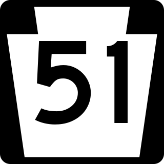
Pennsylvania Route 51 is a major state highway that is located in Western Pennsylvania in the United States. It runs for 89 miles (143 km) from Uniontown to the Ohio state line near Darlington, where it connects with Ohio State Route 14.

<span class="mw-page-title-main">Pennsylvania Route 21</span> State highway in Pennsylvania, US

Pennsylvania Route 21 is a 50.75-mile (81.67 km) long east–west state highway in the US state of Pennsylvania. The western terminus of the route is at the West Virginia state line in Richhill Township, where PA 21 continues into West Virginia as West Virginia Route 891. The eastern terminus is at U.S. Route 40 Business in Uniontown. The route is known as the Roy E. Furman Highway for most of its length. PA 21 serves Waynesburg and Masontown along the way.

<span class="mw-page-title-main">Pennsylvania Route 88</span> State highway in Pennsylvania, US

Pennsylvania Route 88 is a 68-mile-long (109 km) north–south state highway located in southwestern Pennsylvania. The southern terminus of the route is at U.S. Route 119 (US 119) in Point Marion less than 2 miles (3 km) from the Pennsylvania-West Virginia border. The northern terminus is at PA 51 in Pittsburgh. PA 88 runs parallel to the Monongahela River for almost its entire length.

<span class="mw-page-title-main">Pennsylvania Route 136</span> State highway in Pennsylvania, US

Pennsylvania Route 136 is a 40-mile-long (64 km) state highway located in Washington, Allegheny, and Westmoreland counties in Pennsylvania. The western terminus is at US 40 and PA 18 in Washington. The eastern terminus is at US 30 in Greensburg.

<span class="mw-page-title-main">Brownsville Road</span>

Brownsville Road is a road between Pittsburgh, at Eighteenth Street and South Avenue in Allegheny County, Pennsylvania eastwards through Mount Oliver and generally highlands situated along or near the hilltops often overlooking the Monongahela River. It has had several names over its history, and was also known at the Red Stone Road and the period it was a Plank Road managed as a toll road, the Brownsville Plank Road, or the Brownsville Turnpike, or locally, as the area grew into a city, Southern Avenue.

<span class="mw-page-title-main">U.S. Route 119 in Pennsylvania</span> Segment of American highway

U.S. Route 119 (US 119) travels through Connellsville, Greensburg, and Punxsutawney, and bypasses Uniontown and Indiana. There are numerous other boroughs and villages along its 133-mile (214 km) route in the Keystone State. The southern entrance of US 119 is at the West Virginia state line one-half-mile south of Point Marion. The northern terminus is at US 219 two miles (3 km) south of DuBois, Pennsylvania. US 119 is in the National Highway System from the West Virginia state line to Exit 0 of PA Turnpike 66, and from US 22 to US 219. From US 22 to US 219, the highway carries the name of the Buffalo-Pittsburgh Highway; from US 22 to PA 56, it is also known as the Patrick J. Stapleton Highway; near Uniontown, it bears the name George C. Marshall Parkway.

Blainsburg is an unincorporated outlier community of West Brownsville, PA; by tradition a hamlet sized neighborhood with more actual housing acreage than West Brownsville proper in Washington County, Pennsylvania, United States. Named after a U.S. Senator, James G. Blaine. Blainsburg is part of the California Area School District. West Brownsville residence students attend Brownsville Area School District in Fayette County, Pennsylvania. The bedroom community is situated on the bluff above and slightly North-northwest of West Brownsville on the river bottom below. Blainsburg is located alongside but above the climb PA Route 88 makes from the W. Brownsville river flats which bends right entering a shelf where it connects with the northwest streets of Blainsburg before taking a second ascent towards California. The parent and child communities are on the inside curve of a great meander in the Monongahela River in Southwestern Pennsylvania creating a degraded cut bank turned ramp and terrace on the opposite shore where Brownsville is situated. Blainsburg is often misspelled with an "E" in it, to match the spelling of its namesake, James G. Blaine. Blainsburg as of official records was founded in 1906 and is still spelled without the "E".

Redstone Creek is a historically important widemouthed canoe and river boat-navigable brook-sized tributary stream of the Monongahela River in Fayette County, Pennsylvania. The creek is 28.4 miles (45.7 km) long, running from headwaters on Chestnut Ridge north through the city of Uniontown and reaching the Monongahela at Brownsville. Located in a 1/4-mile-wide valley with low streambanks, the site was ideal for ship building in a region geologically most often characterized by steep-plunging relatively inaccessible banks — wide enough to launch and float several large boats, and indeed steamboats after 1811, and slow-moving enough to provide good docks and parking places while craft were outfitting.

<span class="mw-page-title-main">Malden, Pennsylvania</span> Unincorporated hamlet in Pennsylvania, U.S.

The unincorporated hamlet of Malden is a bedroom community that is located on the historic 'Old National Pike' in borough of Centerville Washington County, Pennsylvania. Originally an early wagon stop in rural Pennsylvania, it became a small transportation hub during the surge of westward migration to the Northwest Territory after 1790.

References

  1. 1 2 Google (2008-10-13). "US 40 in Pennsylvania" (Map). Google Maps . Google. Retrieved 2008-10-13.
  2. Google (2008-10-13). "US 40 in Washington County" (Map). Google Maps . Google. Retrieved 2008-10-13.
  3. Google (2008-10-13). "US 40 in Fayette and Somerset Counties" (Map). Google Maps . Google. Retrieved 2008-10-13.
  4. 1 2 "Historic National Road -- Pennsylvania Overview". National Scenic Byways Program. Retrieved 2008-10-24.
  5. 1 2 3 "Timeline". Historic National Road: America's Road to Revolution. National Road PA. Retrieved 2015-12-04.
  6. Joseph S. Mendinghall and S. Sydney Bradford (May 8, 1975). "National Register of Historic Places Inventory-Nomination: Searights Tollhouse, National Road" (pdf). National Park Service.{{cite journal}}: Cite journal requires |journal= (help) and Accompanying 3 photos, exterior, from 1975.  (32 KB)
  7. "Petersburg Tollhouse: Addison, PA". Petersburg Tollhouse: Addison, PA. Daughters of the American Revolution. Retrieved 2015-12-04.
Template:Attached KML/U.S. Route 40 in Pennsylvania
KML is from Wikidata
US 40.svg U.S. Route 40
Previous state:
West Virginia
Pennsylvania Next state:
Maryland