Centerville, Washington County, Pennsylvania

Last updated
Centerville, Pennsylvania
Centerville Historic District.jpg
Former service station in the borough's historic district
Washington County Pennsylvania Incorporated and Unincorporated areas Centerville Highlighted.svg
Location of Centerville in Washington County, Pennsylvania.
USA Pennsylvania location map.svg
Red pog.svg
Centerville, Pennsylvania
Location of Centerville in Pennsylvania
Coordinates: 40°1′51″N79°57′33″W / 40.03083°N 79.95917°W / 40.03083; -79.95917
CountryUnited States
State Pennsylvania
County Washington
Established1895
Government
  MayorDylan Lamp
Area
[1]
  Total13.61 sq mi (35.25 km2)
  Land13.23 sq mi (34.26 km2)
  Water0.39 sq mi (1.00 km2)
Population
 (2020) [2]
  Total3,256
  Density246.16/sq mi (95.05/km2)
Time zone UTC-4 (EST)
  Summer (DST) UTC-5 (EDT)
Area code 724
FIPS code 42-12224
GNIS feature ID1215656

Centerville is a borough in Washington County, Pennsylvania, United States. The population was 3,254 at the 2020 census. [3]

Contents

History

The Centerville Historic District, Joseph Dorsey House, Harrison House and Welsh-Emery House are listed on the National Register of Historic Places. [4]

Geography

Centerville is located at 40°1′51″N79°57′33″W / 40.03083°N 79.95917°W / 40.03083; -79.95917 (40.030766, -79.959107). [5]

According to the United States Census Bureau, the borough has a total area of 13.6 square miles (35 km2), of which 13.2 square miles (34 km2) is land and 0.3 square miles (0.78 km2) (2.57%) is water.

Surrounding and adjacent neighborhoods

Centerville has six land borders, including West Pike Run Township to the north, California to the east and northeast, West Brownsville to the east-southeast, East Bethlehem Township to the south-southwest, Deemston to the west, and Beallsville to the northwest. Across the Monongahela River in Fayette County to the south, Centerville runs adjacent with Brownsville and Luzerne Township.

Demographics

Historical population
CensusPop.Note
1880 150
1900 746
1910 1,41389.4%
1920 4,793239.2%
1930 6,46734.9%
1940 6,317−2.3%
1950 5,845−7.5%
1960 5,088−13.0%
1970 4,175−17.9%
1980 4,2070.8%
1990 3,842−8.7%
2000 3,390−11.8%
2010 3,263−3.7%
2020 3,254−0.3%
2021 (est.)3,234 [3] −0.6%
Sources: [6] [7] [8] [9] [2]

As of the census [7] of 2010, there were 3,263 people, 1,359 households, and 971 families living in the borough. The population density was 255.9 people per square mile (98.8 people/km2). There were 1,455 housing units at an average density of 109.8 per square mile (42.4/km2). The racial makeup of the borough was 98.85% White, 0.18% African American, 0.15% Native American, 0.21% Asian, 0.24% from other races, and 0.38% from two or more races. Hispanic or Latino of any race were 0.27% of the population.

There were 1,359 households, out of which 27.7% had children under the age of 18 living with them, 57.7% were married couples living together, 10.7% had a female householder with no husband present, and 28.5% were non-families. 26.4% of all households were made up of individuals, and 16.1% had someone living alone who was 65 years of age or older. The average household size was 2.49 and the average family size was 3.00.

In the borough the population was spread out, with 21.7% under the age of 18, 7.5% from 18 to 24, 25.5% from 25 to 44, 25.9% from 45 to 64, and 19.4% who were 65 years of age or older. The median age was 42 years. For every 100 females there were 92.9 males. For every 100 females age 18 and over, there were 89.0 males.

The median income for a household in the borough was $34,598, and the median income for a family was $40,741. Males had a median income of $35,804 versus $23,245 for females. The per capita income for the borough was $16,648. About 8.1% of families and 13.3% of the population were below the poverty line, including 24.8% of those under age 18 and 13.1% of those age 65 or over.

Related Research Articles

<span class="mw-page-title-main">Heidelberg Township, Berks County, Pennsylvania</span> Township in Pennsylvania, United States

Heidelberg Township is a township in Berks County, Pennsylvania, United States. The population was 1,726 at the 2020 census.

<span class="mw-page-title-main">Parkesburg, Pennsylvania</span> Borough in Pennsylvania, United States

Parkesburg is a borough in Chester County, Pennsylvania, United States. The population was counted as 3,866 at the 2020 census. The ZIP code is 19365.

<span class="mw-page-title-main">Centerville, Crawford County, Pennsylvania</span> Borough in Pennsylvania, United States

Centerville is a borough in Crawford County, Pennsylvania, United States. The population was 176 at the 2020 census, down from 218 at the 2010 census. It was established in 1812.

<span class="mw-page-title-main">Hydetown, Pennsylvania</span> Borough in Pennsylvania, United States

Hydetown is a borough in Crawford County, Pennsylvania, United States. The population was 526 at the 2020 census, up from 526 at the 2010 census, down from 605 in 2000. It was established in 1862.

<span class="mw-page-title-main">Rome Township, Crawford County, Pennsylvania</span> Township in Pennsylvania, United States

Rome Township is a township in Crawford County, Pennsylvania, United States. The population was 1,993 at the 2020 census, up from 1,840 at the 2010 census.

<span class="mw-page-title-main">Brownsville Township, Pennsylvania</span> Township in Pennsylvania, United States

Brownsville Township is a township in Fayette County, Pennsylvania, United States. The population was 536 at the 2020 census, a decline from the figure of 683 tabulated in 2010. It is served by the Brownsville School District.

<span class="mw-page-title-main">Hiller, Pennsylvania</span> Census-designated place in Pennsylvania, United States

Hiller is an unincorporated community and census-designated place in Fayette County, Pennsylvania, United States. As of the 2010 census, it had a population of 1,155, down from 1,234 at the 2000 census.

<span class="mw-page-title-main">Jefferson Township, Fayette County, Pennsylvania</span> Township in Pennsylvania, United States

Jefferson Township is a township in Fayette County, Pennsylvania, United States. The population was 2,007 at the 2020 census, a decline from the figure of 2,008 tabulated in 2010. It is named for former president Thomas Jefferson, and many of the township's streets are named after other U.S. presidents. Frazier School District serves the area.

<span class="mw-page-title-main">Redstone Township, Pennsylvania</span> Township in Pennsylvania, United States

Redstone Township is a township in Fayette County, Pennsylvania, United States. The population was 5,077 at the 2020 census, a decline from the figure of 5,566 tabulated in 2010. The Brownsville Area School District serves the region.

<span class="mw-page-title-main">West Wheatfield Township, Pennsylvania</span> Township in Pennsylvania, United States

West Wheatfield Township is a township in Indiana County, Pennsylvania, United States. The population was 2,164 at the time of the 2020 census.

<span class="mw-page-title-main">Liverpool Township, Perry County, Pennsylvania</span> Township in Pennsylvania, United States

Liverpool Township is a township in Perry County, Pennsylvania, United States. The population was 1,037 at the 2020 census. It is not to be confused with the borough of Liverpool, which is adjacent.

<span class="mw-page-title-main">Middlecreek Township, Somerset County, Pennsylvania</span> Township in Pennsylvania, United States

Middlecreek Township is a township in Somerset County, Pennsylvania, United States. The population was 831 at the 2020 census. It is part of the Johnstown, Pennsylvania, Metropolitan Statistical Area.

<span class="mw-page-title-main">Milford Township, Somerset County, Pennsylvania</span> Township in Pennsylvania, United States

Milford Township is a township in Somerset County, Pennsylvania, United States. The population was 1,488 at the 2020 census. It is part of the Johnstown, Pennsylvania, Metropolitan Statistical Area.

<span class="mw-page-title-main">New Centerville, Pennsylvania</span> Borough in Pennsylvania, United States

New Centerville is a borough in Somerset County, Pennsylvania, United States. The population was 127 at the 2020 census. It is part of the Johnstown, Pennsylvania, Metropolitan Statistical Area. It should not be confused with the unincorporated village of New Centerville in Tredyffrin Township.

<span class="mw-page-title-main">Oakland Township, Venango County, Pennsylvania</span> Township in Pennsylvania, United States

Oakland Township is a township in Venango County, Pennsylvania, United States. The population was 1,359 at the 2020 census, a decrease from 1,504 in 2010, which represented a decline from the 1,565 residents as of the 2000 census.

<span class="mw-page-title-main">California, Pennsylvania</span> Borough in Pennsylvania, United States

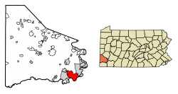
California is a borough on the Monongahela River in Washington County, Pennsylvania, United States. The population was 5,479 as of the 2020 census. It is part of the Pittsburgh metropolitan area.

<span class="mw-page-title-main">Deemston, Pennsylvania</span> Borough in Pennsylvania, United States

Deemston is a borough in Washington County, Pennsylvania, United States and part of the Pittsburgh metropolitan area since 1950. The population was 751 at the 2020 census.

<span class="mw-page-title-main">Hempfield Township, Westmoreland County, Pennsylvania</span> Township in Pennsylvania, United States

Hempfield Township is a township in Westmoreland County, Pennsylvania, United States. The population was 41,585 at the 2020 census, making it the largest suburb in the Pittsburgh Metropolitan Area by population. Its name is derived from Hempfield in Lancaster County, which was formed in 1729 and is named after the hemp fields in the area.

<span class="mw-page-title-main">Oklahoma, Pennsylvania</span> Borough in Pennsylvania, United States

Oklahoma is a borough in Westmoreland County, Pennsylvania, United States. The population was 809 at the time of the 2010 census.

<span class="mw-page-title-main">Sutersville, Pennsylvania</span> Borough in Pennsylvania, United States

Sutersville is a borough in Westmoreland County, Pennsylvania, United States. The population was 605 at the 2010 census.

References

  1. "ArcGIS REST Services Directory". United States Census Bureau. Retrieved October 12, 2022.
  2. 1 2 "Census Population API". United States Census Bureau. Retrieved Oct 12, 2022.
  3. 1 2 Bureau, US Census. "City and Town Population Totals: 2020-2021". Census.gov. US Census Bureau. Retrieved 21 July 2022.
  4. "National Register Information System". National Register of Historic Places . National Park Service. July 9, 2010.
  5. "US Gazetteer files: 2010, 2000, and 1990". United States Census Bureau. 2011-02-12. Retrieved 2011-04-23.
  6. "Census of Population and Housing". U.S. Census Bureau. Retrieved 11 December 2013.
  7. 1 2 "U.S. Census website". United States Census Bureau . Retrieved 2008-01-31.
  8. "Incorporated Places and Minor Civil Divisions Datasets: Subcounty Resident Population Estimates: April 1, 2010 to July 1, 2012". Population Estimates. U.S. Census Bureau. Archived from the original on 11 June 2013. Retrieved 11 December 2013.
  9. "Census of Population and Housing". Census.gov. Retrieved June 4, 2016.