Thompsonville, Pennsylvania

Last updated
Thompsonville
Map of Thompsonville, Washington County, Pennsylvania Highlighted.png
Location of Thompsonville in Washington County
Coordinates: 40°16′53″N80°7′11″W / 40.28139°N 80.11972°W / 40.28139; -80.11972 Coordinates: 40°16′53″N80°7′11″W / 40.28139°N 80.11972°W / 40.28139; -80.11972
CountryUnited States
StatePennsylvania
County Washington
Area
  Total2.1 sq mi (5 km2)
Population
 (2010)
  Total3,520
  Density1,700/sq mi (650/km2)
Time zone UTC-4 (EST)
  Summer (DST) UTC-5 (EDT)
ZIP code
15317 [1]
Area code 724

Thompsonville is a census-designated place (CDP) in Washington County, Pennsylvania, United States. The population was 3,520 at the 2010 census.

Contents

Geography

Thompsonville is located at 40°16′53″N80°7′11″W / 40.28139°N 80.11972°W / 40.28139; -80.11972 (40.281373, -80.119665). [2]

According to the United States Census Bureau, the CDP has a total area of 2.1 square miles (5.4 km2), of which, 2.0 square miles (5.2 km2) of it is land and 0.04 square miles (0.10 km2) of it (1.44%) is water.

Demographics

At the 2000 census there were 3,592 people, 1,228 households, and 1,024 families living in the CDP. The population density was 1,753.8 people per square mile (677.1 people/km2). There were 1,254 housing units at an average density of 612.3 per square mile (236.4/km2). The racial makeup of the CDP was 98.13% White, 0.33% African American, 0.06% Native American, 0.81% Asian, 0.28% from other races, and 0.39% from two or more races. Hispanic or Latino of any race were 0.70%. [3]

Of the 1,228 households 34.7% had children under the age of 18 living with them, 76.8% were married couples living together, 4.3% had a female householder with no husband present, and 16.6% were non-families. 14.7% of households were one person and 7.6% were one person aged 65 or older. The average household size was 2.73 and the average family size was 3.03.

The age distribution was 24.3% under the age of 18, 4.0% from 18 to 24, 20.7% from 25 to 44, 29.0% from 45 to 64, and 22.0% 65 or older. The median age was 46 years. For every 100 females, there were 88.5 males. For every 100 females age 18 and over, there were 84.6 males.

The median household income was $75,000 and the median family income was $89,587. Males had a median income of $70,240 versus $38,839 for females. The per capita income for the CDP was $36,853. About 2.5% of families and 3.9% of the population were below the poverty line, including 2.2% of those under age 18 and 3.9% of those age 65 or over.

Related Research Articles

<span class="mw-page-title-main">Broad Brook, Connecticut</span> Census-designated place in Connecticut, United States

Broad Brook is a neighborhood and census-designated place (CDP) in the town of East Windsor, Hartford County, Connecticut, United States. As of the 2010 census, the CDP population was 4,069.

Sherwood Manor is a census-designated place (CDP) within the town of Enfield in Hartford County, Connecticut, United States. The population was 5,410 at the 2010 census.

<span class="mw-page-title-main">Thompsonville, Connecticut</span> Census-designated place in Connecticut, United States

Thompsonville is a census-designated place (CDP) in the town of Enfield in Hartford County, Connecticut, United States. The population of the CDP was 8,577 at the 2010 census.

<span class="mw-page-title-main">Okahumpka, Florida</span> Census-designated place in Florida

Okahumpka is an unincorporated community and census-designated place (CDP) in Lake County, Florida, United States. The population was 267 at the 2010 census. It is part of the Orlando–Kissimmee Metropolitan Statistical Area.

<span class="mw-page-title-main">Three Lakes, Florida</span> Census-designated place in Florida, United States

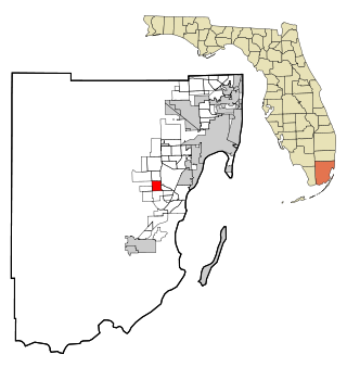
Three Lakes is a census-designated place (CDP) in Miami-Dade County, Florida, United States. The population was 16,540 at the 2020 census, up from 15,047 in 2010. Its name comes from the planned community of Three Lakes, which is located inside Three Lakes CDP boundaries.

<span class="mw-page-title-main">Beacon Square, Florida</span> CDP in Florida, United States

Beacon Square is a census-designated place (CDP) in Pasco County, Florida, United States. The population was 7,263 at the 2000 census.

<span class="mw-page-title-main">Thompsonville, Illinois</span> Village in Illinois, United States

Thompsonville is a village in Cave Township, Franklin County, Illinois, United States. The population was 543 at the 2010 census.

<span class="mw-page-title-main">Brunswick Station, Maine</span> Census-designated place in Maine, United States

Brunswick Station was a census-designated place (CDP) within the town of Brunswick in Cumberland County, Maine, United States. The population was 578 at the 2010 census. It consists of an area that was part of the former Naval Air Station Brunswick and was part of the Portland–South Portland–Biddeford, Maine Metropolitan Statistical Area. The 2020 census shows it as part of the Brunswick CDP.

<span class="mw-page-title-main">Masury, Ohio</span> Census-designated place in Ohio, United States

Masury is an unincorporated community and census-designated place in eastern Trumbull County, Ohio, United States. The population was 2,001 at the 2020 census. It is part of the Youngstown–Warren metropolitan area.

<span class="mw-page-title-main">Carnot-Moon, Pennsylvania</span> Census-designated place in Pennsylvania, United States

Carnot-Moon is a census-designated place (CDP) in central Moon Township, Allegheny County, Pennsylvania, United States. The population was 13,151 at the 2020 census.

Spring Ridge is a census-designated place (CDP) in Spring Township, Berks County, Pennsylvania, United States. The population was 1,003 at the 2010 census.

<span class="mw-page-title-main">Fox Run, Pennsylvania</span> Former census-designated place in Pennsylvania, United States

Fox Run is a neighborhood in Cranberry Township, Butler County, Pennsylvania, United States. It is among the Township's earliest housing developments, including 320 homes built on a 131-acre site in the late 1960s. It was formerly a census-designated place (CDP), but that designation was removed as of TIGER 2013 after Cranberry Township officials pointed out that users of Internet mapping websites had misinterpreted the CDP as the name of its parent municipality.

<span class="mw-page-title-main">Cecil-Bishop, Pennsylvania</span> CDP in Pennsylvania, United States

Cecil-Bishop is a census-designated place (CDP) in Washington County, Pennsylvania, United States. The population was 2,730 at the 2020 census. The census-designated place encompasses two unincorporated communities: larger Cecil in the west and smaller Bishop in the east.

<span class="mw-page-title-main">Gastonville, Pennsylvania</span> Census-designated place in Pennsylvania, United States

Gastonville is a census-designated place (CDP) in Washington County, Pennsylvania, United States. The population was 2,818 at the 2010 census.

<span class="mw-page-title-main">McMurray, Pennsylvania</span> Census-designated place in Pennsylvania, United States

McMurray is a census-designated place (CDP) in Peters Township, Washington County, Pennsylvania. The population was 4,736 at the 2020 census. It is part of the Pittsburgh metropolitan area. Its zip code is 15317, which it shares with neighboring borough Canonsburg.

Lawson Heights is a census-designated place (CDP) in Unity Township, Westmoreland County, Pennsylvania, United States. The population was 2,339 at the 2000 census.

<span class="mw-page-title-main">Three Lakes, Washington</span> CDP in Washington, United States

Three Lakes is a census-designated place (CDP) in Snohomish County, Washington, United States. The population was 3,184 at the 2010 census.

<span class="mw-page-title-main">Hooverson Heights, West Virginia</span> Census-designated place in West Virginia, United States

Hooverson Heights is a census-designated place (CDP) in Brooke County, West Virginia, United States. It is part of the Weirton–Steubenville metropolitan area. The population was 2,590 at the 2010 census.

<span class="mw-page-title-main">Nantucket (CDP), Massachusetts</span> CDP in Massachusetts, United States

Nantucket is a census-designated place (CDP) in the town of Nantucket in Nantucket County, Massachusetts, United States. The population was 7,446 at the 2010 census.

Machias is a census-designated place (CDP) corresponding to the central village area within the town of Machias in Washington County, Maine, United States. The population of the CDP was 1,274 at the 2010 census.

References

  1. "Thompsonville PA ZIP Code". zipdatamaps.com. 2023. Retrieved May 13, 2023.
  2. "US Gazetteer files: 2010, 2000, and 1990". United States Census Bureau. 2011-02-12. Retrieved 2011-04-23.
  3. "U.S. Census website". United States Census Bureau . Retrieved 2008-01-31.