West Brownsville, Pennsylvania

Last updated
West Brownsville
Perspective view of truss span, looking NE. - Pennsylvania Railroad, West Brownsville Junction Bridge, Spanning Monongahela River, north of U.S. Route 40 Bridge, West Brownsville, HAER PA,63-BROVW,1-2.tif
West Brownsville Junction Bridge, spanning the Monongahela River
Washington County Pennsylvania Incorporated and Unincorporated areas West Brownsville Highlighted.svg
Location of West Brownsville in Washington County, Pennsylvania.
USA Pennsylvania location map.svg
Red pog.svg
West Brownsville
Location of West Brownsville in Pennsylvania
Coordinates: 40°1′47″N79°53′11″W / 40.02972°N 79.88639°W / 40.02972; -79.88639
CountryUnited States
State Pennsylvania
County Washington
Established1831
Government
   Mayor W Dean Lacey
   Borough Council [1]
Members
  • Jim Pflugh
  • Von Braddock
  • Richard Black
  • Brianne Bayer-Mitchell
  • Dan Krilosky
  • Debby King
  • I. Patrick Toth
Area
[2]
  Total1.42 sq mi (3.68 km2)
  Land1.30 sq mi (3.36 km2)
  Water0.12 sq mi (0.32 km2)
Population
 (2020) [3]
  Total977
  Density752.12/sq mi (290.42/km2)
Time zone UTC-4 (EST)
  Summer (DST) UTC-5 (EDT)
ZIP code
15417 [4]
Greater Pittsburgh 724

West Brownsville is a former important transportation nexus and a present-day borough in Washington County, Pennsylvania, United States and part of the Pittsburgh metropolitan area. The population was 972 at the 2020 census. [5] Culturally, by postal route, and socially, the community is connected to cross-river sister-city Brownsville, for the two were long joined by the Amerindian trail known as Nemacolin's Path that became a wagon road after the American Revolution, but West Brownsville is a separate municipality. Brownsville was the first point where the descent from the Appalachians could safely reach the river down the generally steep banks of the Monongahela River. Between Brownsville and West Brownsville was a shallow stretch, usable as a river ford astride a major Emigrant Trail to the various attractive regions in the Northwest Territory, the first National Road, the Cumberland Pike (Now U.S. Route 40 [lower-alpha 1] ).

Contents

Geography

West Brownsville is located at 40°1′47″N79°53′11″W / 40.02972°N 79.88639°W / 40.02972; -79.88639 (40.029731, -79.886412). [6]

According to the United States Census Bureau, the borough has a total area of 1.4 square miles (3.6 km2), of which 1.3 square miles (3.4 km2) is land and 0.1 square miles (0.26 km2) (8.51%) is water.

History

West Brownsville was sited on the inside of the sweeping curve along the Monongahela River and has relatively level ground opposite the cut bank effect giving Brownsville relatively steep slopes and West Brownsville, cupped by the inside of the curve, more flood-prone sandy mud flats lands. Historically, at a bit upstream of the location of the Brownsville-West Brownsville Bridge was the Amerindian crossing ford and wagon road of early westward migrants. A few hundred yards west from the shoreline, PA Route 88 enters from along the riverside bluff and the south as Lowhill Road and hugs the foot of the steep Pennsylvania hillsides flanking tongue-shaped flat terrain of the streets and housing through most of the length of W. Brownsville before twisting left uphill. It exits the W. Brownsville flat climbing Northwest as Blainsburg Road, climbing beside and below the bluff of Blainsburg, a larger 'satellite' bedroom community really an extension of the community, situated above West Brownsville proper, to its North-Northwest.

The steep bluff behind the West Brownsville tongue provided two climbable ascents which became early U.S. roads; the more southerly heading nearly due west climbing steadily upwards over a 2.5 miles (4.0 km) stretch, an old wagon road, and later the National Road following the westward extension of Nemacolin's Path up to and through the outlier neighborhood known as Malden from a river-shallows area known as a ford to Amerindians, a landscape feature which attracted settlers heading west on the Emigrant Trail once known as Nemacolin's Path, then the Cumberland Road and then renamed as the 'National Road'. The other ascent would allow PA Route 88 to climb out of the valley where the road cut across several loops of the Monongahela to California. [lower-alpha 2]

Transportation and railroad

This map of the Monongahela Railroad Shortline shows the lower "Brownsville Junction" crossing bridge in between Brownsville and West Brownsville. The rail bridge is downriver from the former ferry ramps between the towns and both the old and new U.S. Route 40 bridges. Coke ovens lined the east bank trackage and the bridge off map to the north allowed entire trains to pull through and turn around for the run back to Fayette and Greene County, Pennsylvanian and West Virginian mines, keeping throughput up, and reducing the time dumping tracks were blocked by empty train consists of hopper cars. Monongahela Railway (route map).png
This map of the Monongahela Railroad Shortline shows the lower "Brownsville Junction" crossing bridge in between Brownsville and West Brownsville. The rail bridge is downriver from the former ferry ramps between the towns and both the old and new U.S. Route 40 bridges. Coke ovens lined the east bank trackage and the bridge off map to the north allowed entire trains to pull through and turn around for the run back to Fayette and Greene County, Pennsylvanian and West Virginian mines, keeping throughput up, and reducing the time dumping tracks were blocked by empty train consists of hopper cars.
Street running through West Brownsville. WBvillestreetrunning.jpg
Street running through West Brownsville.

Sundered by the county boundaries running down the center of the river, West Brownsville economically was integrated with cross-river Brownsville by a ferry dating back into the early 1800s when Brownsville became a riverboat building and outfitting center. With construction of boats on nearby large tributaries, the shallow banks of West Brownsville were a favorite location to tie up and outfit a new built water craft to outfit it and load cargoes. The modern-day Main Street is notable for featuring on-street running by freight trains down the center of the street. Considered one railroad crossing, it is one of the longest crossings in the United States. Along with right bank Brownsville on the opposite shore, West Brownsville and Brownsville hosted extensive rail yards jammed into the tight confines along both banks of the Monongahela River. One special feature at either end of the two railyards was they each shared a bridge joining two river crossing wyes that tied together to contain a rare true-life reversing loop, normally a feature only found in model railroading layouts. The yards serviced the extensive rail hopper car deliveries feeding the coking ovens up river along the southside of Brownsville, and were integral parts of the famous Pittsburgh Steel Industries. The Monongahela Railroad represented the Lake Erie, the PRR, and the B&O, and Norfolk and Western both utilized the trackage in the towns, which today is operated by the N&W's successor, Norfolk Southern with the Monongahela vanishing into the Conrail debacle.

Demographics

Historical population
CensusPop.Note
1850 477
1860 61328.5%
1870 547−10.8%
1880 5714.4%
1890 73528.7%
1900 7421.0%
1910 2,036174.4%
1920 1,900−6.7%
1930 1,717−9.6%
1940 1,8447.4%
1950 1,610−12.7%
1960 1,90718.4%
1970 1,426−25.2%
1980 1,4330.5%
1990 1,170−18.4%
2000 1,075−8.1%
2010 992−7.7%
2020 972−2.0%
2021 (est.)970 [5] −0.2%
U.S. Decennial Census [7]

As of the census [8] of 2000, there were 1,075 people, 459 households, and 312 families residing in the borough. The population density was 831.7 inhabitants per square mile (321.1/km2). There were 527 housing units at an average density of 407.7 per square mile (157.4/km2). The racial makeup of the borough was 98.14% White, 0.65% African American, 0.09% Native American, 0.74% from other races, and 0.37% from two or more races. Hispanic or Latino of any race were 0.37% of the population.

There were 459 households, out of which 24.4% had children under the age of 18 living with them, 51.0% were married couples living together, 10.5% had a female householder with no husband present, and 32.0% were non-families. 27.9% of all households were made up of individuals, and 15.0% had someone living alone who was 65 years of age or older. The average household size was 2.34 and the average family size was 2.82.

In the borough the population was spread out, with 16.8% under the age of 18, 10.1% from 18 to 24, 25.5% from 25 to 44, 25.5% from 45 to 64, and 22.0% who were 65 years of age or older. The median age was 43 years. For every 100 females, there were 96.5 males. For every 100 females age 18 and over, there were 94.3 males.

The median income for a household in the borough was $27,315, and the median income for a family was $36,641. Males had a median income of $31,964 versus $21,875 for females. The per capita income for the borough was $15,368. About 10.4% of families and 13.5% of the population were below the poverty line, including 33.3% of those under age 18 and 5.4% of those age 65 or over.

Notes

  1. In the late 1950s in order to ease a perennial traffic jam, the upper stretch of Brownsville's Market Street was subjected to eminent domain and widened to have four lanes of traffic plus parking. In the same project lower Market street and the zig-zag of U.S. Route 40 across the West Brownsville bridge and a hilly loop of the National Road to Malden, Pennsylvania, was bypassed by construction of the Lane Bane Bridge viaduct and a three mile stretch of four lane divided highway as a new path of U.S. Route 40. Subsequently, the old path of U.S. 40 have been renamed Old US40. Old National Pike, and such references.
  2. PA Route 88 is a left bank road that generally follows the Monongahela from just above West Virginia to the outskirts of Pittsburgh, at PA Route 51 near the Liberty Tunnel. The Norfolk and Western bridge crosses above the highway junction near the tunnel mouth and downtown Pittsburgh is just 'through Mount Washington' and across the Monongahela.

Notable residents

Related Research Articles

<span class="mw-page-title-main">Dravosburg, Pennsylvania</span> Borough in Pennsylvania, United States

Dravosburg is a borough in Allegheny County, Pennsylvania, United States, and is part of the Pittsburgh Metro Area. The population was 1,612 at the 2020 census. Dravosburg is located along the Monongahela River.

<span class="mw-page-title-main">Beaver Meadows, Pennsylvania</span> Borough in Pennsylvania, United States

Beaver Meadows is a borough in Carbon County, Pennsylvania, United States. It is part of Northeastern Pennsylvania. The population was 897 at the 2020 U.S. census.

<span class="mw-page-title-main">Belle Vernon, Pennsylvania</span> Borough in Pennsylvania, United States

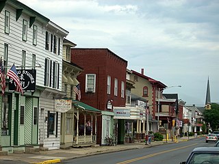
Belle Vernon is a borough in Fayette County, Pennsylvania, United States. It is situated along the Monongahela River, abutting two other counties, Westmoreland to the north and Washington across the river. As of the 2020 census, Belle Vernon had a population of 1,025.

<span class="mw-page-title-main">Brownsville, Pennsylvania</span> Borough in Pennsylvania, United States

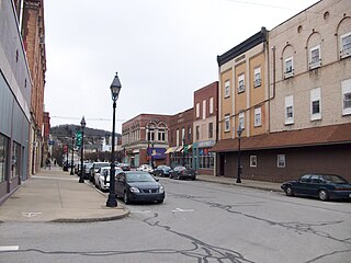
Brownsville is a borough in Fayette County, Pennsylvania, United States, first settled in 1785 as the site of a trading post a few years after the defeat of the Iroquois enabled a resumption of westward migration after the Revolutionary War. The trading post soon became a tavern and inn and was receiving emigrants heading west, as it was located above the cut bank overlooking the first ford that could be reached to those descending from the Allegheny Mountains. Brownsville is located 40 miles (64 km) south of Pittsburgh along the east bank of the Monongahela River.

<span class="mw-page-title-main">Brownsville Township, Pennsylvania</span> Township in Pennsylvania, United States

Brownsville Township is a township in Fayette County, Pennsylvania, United States. The population was 536 at the 2020 census, a decline from the figure of 683 tabulated in 2010. It is served by the Brownsville School District.

<span class="mw-page-title-main">Fayette City, Pennsylvania</span> Borough in Pennsylvania, United States

Fayette City is a borough in Fayette County, Pennsylvania, United States. The population was 502 at the 2020 census, a decline from the figure of 596 tabulated in 2010. It is served by the Belle Vernon Area School District. Some buildings in the town antedate 1820.

<span class="mw-page-title-main">Jefferson Township, Fayette County, Pennsylvania</span> Township in Pennsylvania, United States

Jefferson Township is a township in Fayette County, Pennsylvania, United States. The population was 2,007 at the 2020 census, a decline from the figure of 2,008 tabulated in 2010. It is named for former president Thomas Jefferson, and many of the township's streets are named after other U.S. presidents. Frazier School District serves the area.

<span class="mw-page-title-main">Carmichaels, Pennsylvania</span> Borough in Pennsylvania, United States

Carmichaels is a borough in Greene County, Pennsylvania, United States. The population was 434 at the 2020 census, a decline from the figure of 483 tabulated in 2010.

<span class="mw-page-title-main">Nemacolin, Pennsylvania</span> Census-designated place in Pennsylvania, United States

Nemacolin is a census-designated place (CDP) in Greene County, Pennsylvania, United States. It was founded as a company town around the workings of a Youngstown Sheet and Tube Company that owned and operated a coal mine in 1917. The name reflects a noted Amerindian ally Chief Nemacolin, who showed the Virginia and Pennsylvania settlers how to cross the successive Allegheny barrier ridges via the Cumberland Narrows and the Nemacolin Trail—which Braddock Expedition widened into a wagon road through the mountains. The population of the CDP was 937 at the 2010 census.

<span class="mw-page-title-main">Watsontown, Pennsylvania</span> Borough in Pennsylvania, United States

Watsontown is a borough in Northumberland County, Pennsylvania, United States. The population was 2,351 at the 2010 census. It was named for John Watson, an early settler.

<span class="mw-page-title-main">California, Pennsylvania</span> Borough in Pennsylvania, United States

California is a borough on the Monongahela River in Washington County, Pennsylvania, United States. The population was 5,479 as of the 2020 census. It is part of the Pittsburgh metropolitan area.

<span class="mw-page-title-main">Monongahela, Pennsylvania</span> City in Pennsylvania, United States

Monongahela, referred to locally as Mon City, is a third class city in Washington County, Pennsylvania, United States. The population was 4,149 at the 2020 census. It is part of the Pittsburgh metropolitan area, about 17 miles (27 km) south of Pittsburgh proper.

<span class="mw-page-title-main">North Charleroi, Pennsylvania</span> Borough in Pennsylvania, United States

North Charleroi is a borough in Washington County, Pennsylvania, United States. The population was 1,302 at the 2020 census.

Redstone Old Fort — or Redstone Fort or Fort Burd — on the Nemacolin Trail, was the name of the French and Indian War-era wooden fort built in 1759 by Pennsylvania militia colonel James Burd to guard the ancient Indian trail's river ford on a mound overlooking the eastern shore of the Monongahela River in what is now Fayette County, Pennsylvania, near, or on the banks of Dunlap's Creek at the confluence. The site is unlikely to be the same as an earlier fort the French document as Hangard dated to 1754 and which was confusedly, likely located on the nearby stream called Redstone Creek. Red sandstones predominate the deposited rock column of the entire region.

<span class="mw-page-title-main">U.S. Route 40 in Pennsylvania</span> Segment of American highway

U.S. Route 40 enters Pennsylvania at West Alexander. It closely parallels Interstate 70 (I-70) from West Virginia until it reaches Washington, where it follows Jefferson Avenue and Maiden Street. In Washington, US 40 passes to the south of Washington & Jefferson College. Following Maiden Street out of town, the road turns southeast toward the town of California. A short limited access highway in California and West Brownsville provides an approach to the Lane Bane Bridge across the Monongahela River. From here, the road continues southeast to Uniontown.

<span class="mw-page-title-main">Brownsville Road</span>

Brownsville Road is a road between Pittsburgh, at Eighteenth Street and South Avenue in Allegheny County, Pennsylvania eastwards through Mount Oliver and generally highlands situated along or near the hilltops often overlooking the Monongahela River. It has had several names over its history, and was also known at the Red Stone Road and the period it was a Plank Road managed as a toll road, the Brownsville Plank Road, or the Brownsville Turnpike, or locally, as the area grew into a city, Southern Avenue.

<span class="mw-page-title-main">Malden Inn</span> United States historic place

The Malden Inn is an historic, American building that is located in the unincorporated bedroom community of Malden, Pennsylvania at the junction of South Malden Road and Old U.S. Route 40 (US40).

Blainsburg is an unincorporated outlier community of West Brownsville, PA; by tradition a hamlet sized neighborhood with more actual housing acreage than West Brownsville proper in Washington County, Pennsylvania, United States. Named after a U.S. Senator, James G. Blaine. Blainsburg is part of the California Area School District. West Brownsville residence students attend Brownsville Area School District in Fayette County, Pennsylvania. The bedroom community is situated on the bluff above and slightly North-northwest of West Brownsville on the river bottom below. Blainsburg is located alongside but above the climb PA Route 88 makes from the W. Brownsville river flats which bends right entering a shelf where it connects with the northwest streets of Blainsburg before taking a second ascent towards California. The parent and child communities are on the inside curve of a great meander in the Monongahela River in Southwestern Pennsylvania creating a degraded cut bank turned ramp and terrace on the opposite shore where Brownsville is situated. Blainsburg is often misspelled with an "E" in it, to match the spelling of its namesake, James G. Blaine. Blainsburg as of official records was founded in 1906 and is still spelled without the "E".

Redstone Creek is a historically important widemouthed canoe and river boat-navigable brook-sized tributary stream of the Monongahela River in Fayette County, Pennsylvania. The creek is 28.4 miles (45.7 km) long, running from headwaters on Chestnut Ridge north through the city of Uniontown and reaching the Monongahela at Brownsville. Located in a 1/4-mile-wide valley with low streambanks, the site was ideal for ship building in a region geologically most often characterized by steep-plunging relatively inaccessible banks — wide enough to launch and float several large boats, and indeed steamboats after 1811, and slow-moving enough to provide good docks and parking places while craft were outfitting.

<span class="mw-page-title-main">Malden, Pennsylvania</span> Unincorporated hamlet in Pennsylvania, U.S.

The unincorporated hamlet of Malden is a bedroom community that is located on the historic 'Old National Pike' in borough of Centerville Washington County, Pennsylvania. Originally an early wagon stop in rural Pennsylvania, it became a small transportation hub during the surge of westward migration to the Northwest Territory after 1790.

References

  1. "Mayor, Council, Government |".{{cite web}}: Missing or empty |url= (help)
  2. "ArcGIS REST Services Directory". United States Census Bureau. Retrieved October 16, 2022.
  3. "Census Population API". United States Census Bureau. Retrieved Oct 12, 2022.
  4. "West Brownsville PA ZIP Code". zipdatamaps.com. 2023. Retrieved June 27, 2023.
  5. 1 2 Bureau, US Census. "City and Town Population Totals: 2020-2021". Census.gov. US Census Bureau. Retrieved 22 July 2022.
  6. "US Gazetteer files: 2010, 2000, and 1990". United States Census Bureau. 2011-02-12. Retrieved 2011-04-23.
  7. "Census of Population and Housing". Census.gov. Retrieved June 4, 2016.
  8. "U.S. Census website". United States Census Bureau . Retrieved 2008-01-31.