Claysville, Pennsylvania

Last updated
Claysville, Pennsylvania
Montgomery House in Claysville.jpg
The Montgomery House, a historic building on the borough's western edge
Etymology: Henry Clay
Washington County Pennsylvania Incorporated and Unincorporated areas Claysville Highlighted.svg
Location of Claysville in Washington County, Pennsylvania.
USA Pennsylvania location map.svg
Red pog.svg
Claysville, Pennsylvania
Location of Claysville in Pennsylvania
Usa edcp location map.svg
Red pog.svg
Claysville, Pennsylvania
Claysville, Pennsylvania (the United States)
Coordinates: 40°7′8″N80°24′45″W / 40.11889°N 80.41250°W / 40.11889; -80.41250
CountryUnited States
State Pennsylvania
County Washington
Established1812
Government
  MayorGeno Sibert
Area
[1]
  Total0.32 sq mi (0.82 km2)
  Land0.31 sq mi (0.80 km2)
  Water0.01 sq mi (0.01 km2)
Population
 (2020) [2]
  Total733
  Density2,372.17/sq mi (914.72/km2)
Time zone UTC-4 (EST)
  Summer (DST) UTC-5 (EDT)
ZIP code
15323 [3]
Area code 724

Claysville is a borough in Washington County, Pennsylvania, United States and part of the Pittsburgh metropolitan area since 1950. [4] The population was 728 at the 2020 census. [5] Claysville Elementary School, part of the McGuffey School District is located in Claysville. It is the birthplace of Benjamin Franklin Jones of the Jones and Laughlin Steel Company.

Contents

History

The Montgomery House was listed on the National Register of Historic Places in 2002. [6]

Geography

Claysville is located at 40°7′8″N80°24′45″W / 40.11889°N 80.41250°W / 40.11889; -80.41250 (40.118984, -80.412536). [7]

According to the United States Census Bureau, the borough has a total area of 0.3 square miles (0.78 km2), of which 0.3 square miles (0.78 km2) is land and 3.12% is water.

Demographics

Historical population
CensusPop.Note
1850 275
1860 2988.4%
1870 284−4.7%
1880 32313.7%
1890 1,041222.3%
1900 856−17.8%
1910 1,04522.1%
1920 1,009−3.4%
1930 912−9.6%
1940 9706.4%
1950 963−0.7%
1960 9862.4%
1970 951−3.5%
1980 1,0298.2%
1990 962−6.5%
2000 724−24.7%
2010 82914.5%
2020 728−12.2%
2021 (est.)723 [5] −0.7%
Sources: [8] [9] [10] [11] [2]

As of the census [9] of 2000, there were 724 people, 242 households, and 189 families residing in the borough. The population density was 2,349.8 inhabitants per square mile (907.3/km2). There were 261 housing units at an average density of 847.1 per square mile (327.1/km2). The racial makeup of the borough was 99.45% White, 0.28% African American, and 0.28% from two or more races.

There were 242 households, out of which 35.1% had children under the age of 18 living with them, 60.7% were married couples living together, 12.8% had a female householder with no husband present, and 21.9% were non-families. 19.4% of all households were made up of individuals, and 14.0% had someone living alone who was 65 years of age or older. The average household size was 2.73 and the average family size was 3.06.

In the borough the population was spread out, with 25.6% under the age of 18, 6.4% from 18 to 24, 26.2% from 25 to 44, 21.0% from 45 to 64, and 20.9% who were 65 years of age or older. The median age was 40 years. For every 100 females, there were 90.0 males. For every 100 females age 18 and over, there were 87.8 males.

The median income for a household in the borough was $36,000, and the median income for a family was $40,000. Males had a median income of $28,125 versus $21,591 for females. The per capita income for the borough was $14,785. About 12.4% of families and 13.4% of the population were below the poverty line, including 16.1% of those under age 18 and 18.4% were above age 64.

Related Research Articles

<span class="mw-page-title-main">Emsworth, Pennsylvania</span> Borough in Allegheny County, Pennsylvania, United States

Emsworth is a borough in Allegheny County, Pennsylvania, United States, along the Ohio River. The population was 2,525 at the 2020 census.

<span class="mw-page-title-main">Haysville, Pennsylvania</span> Borough in Pennsylvania, United States

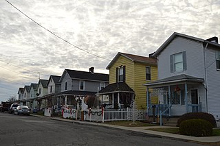
Haysville is a borough in Allegheny County, Pennsylvania, United States, along the Ohio River. The population was 81 according to the 2020 census, making it the least-populous municipality in Allegheny County.

<span class="mw-page-title-main">Rankin, Pennsylvania</span> Borough in Pennsylvania, United States

Rankin is a borough in Allegheny County, Pennsylvania, United States, 8 miles (13 km) south of Pittsburgh on the Monongahela River. The borough was named after Thomas Rankin, a local landowner. Early in the 20th century, Rankin specialized in manufacturing steel and wire goods. The population increased from 3,775 in 1900 to 7,470 in 1940, and has since declined to 1,896 as of the 2020 census.

<span class="mw-page-title-main">Thornburg, Pennsylvania</span> Borough in Pennsylvania, United States

Thornburg is a borough in Allegheny County in the U.S. state of Pennsylvania. The population was 466 at the 2020 census.

<span class="mw-page-title-main">West Kittanning, Pennsylvania</span> Borough in Pennsylvania, United States

West Kittanning is a borough in Armstrong County, Pennsylvania, United States. The population was 1,192 at the 2020 census.

<span class="mw-page-title-main">Bridgewater, Pennsylvania</span> Borough in Pennsylvania, United States

Bridgewater is a borough in central Beaver County, Pennsylvania, United States, at the confluence of the Beaver and Ohio rivers. The population was 744 at the 2020 census. It is part of the Pittsburgh metropolitan area. The borough is best known as the home of the Bruster's Ice Cream chain. A few scenes in the 1986 movie Gung Ho were also shot in Bridgewater. Much of Bridgewater, including its two major streets, are included in the Bridgewater Historic District.

<span class="mw-page-title-main">East Rochester, Pennsylvania</span> Borough in Pennsylvania, United States

East Rochester is a borough in central Beaver County, Pennsylvania, along the Ohio River. The population was 563 at the 2020 census. It is part of the Pittsburgh metropolitan area.

<span class="mw-page-title-main">Glasgow, Pennsylvania</span> Borough in Pennsylvania, United States

Glasgow is a borough in Beaver County, Pennsylvania, United States, along the Ohio River. The population was 71 at the 2020 census.

<span class="mw-page-title-main">Connoquenessing, Pennsylvania</span> Borough in Pennsylvania, United States

Connoquenessing is a borough in Butler County, Pennsylvania, United States. The population was 528 at the 2010 census.

<span class="mw-page-title-main">Prospect, Pennsylvania</span> Borough in Pennsylvania, United States

Prospect is a borough in Butler County, Pennsylvania, United States. As of the 2010 census, the borough had a population of 1,169.

<span class="mw-page-title-main">Seven Fields, Pennsylvania</span> Place in Pennsylvania, United States

Seven Fields is a borough in Butler County, Pennsylvania, United States. The population was 2,887 at the 2010 census, an increase from the figure of 1,986 tabulated in 2000.

<span class="mw-page-title-main">Shippenville, Pennsylvania</span> Borough in Pennsylvania, United States

Shippenville is a borough in Clarion County, Pennsylvania, United States. The population was 446 at the 2020 census.

<span class="mw-page-title-main">Corsica, Pennsylvania</span> Borough in Pennsylvania, United States

Corsica is a borough in Jefferson County, Pennsylvania, United States. The population was 357 at the 2010 census. It was named for the island of Corsica, birthplace of Napoleon Bonaparte. The mayor of the borough is Dave Leadbetter.

<span class="mw-page-title-main">Bessemer, Lawrence County, Pennsylvania</span> Borough in Pennsylvania, United States

Bessemer is a borough in Lawrence County, Pennsylvania, United States. The population was 1,073 at the 2020 census. It is part of the New Castle micropolitan area.

<span class="mw-page-title-main">Enon Valley, Pennsylvania</span> Borough in Pennsylvania, United States

Enon Valley is a borough in Lawrence County, Pennsylvania, United States. The population was 297 at the 2020 census. It is part of the New Castle micropolitan area.

<span class="mw-page-title-main">South New Castle, Pennsylvania</span> Borough in Pennsylvania, United States

South New Castle is a borough in Lawrence County, Pennsylvania, United States. The population was 649 at the 2020 census. It is primarily a residential community which lies south of the city of New Castle, and is part of the New Castle micropolitan area.

<span class="mw-page-title-main">Deemston, Pennsylvania</span> Borough in Pennsylvania, United States

Deemston is a borough in Washington County, Pennsylvania, United States and part of the Pittsburgh metropolitan area since 1950. The population was 751 at the 2020 census.

<span class="mw-page-title-main">Ellsworth, Pennsylvania</span> Borough in Pennsylvania, United States

Ellsworth is a borough in Washington County, Pennsylvania, United States. The population was 947 at the 2020 census. The coal town was founded by James Ellsworth, who bought the land in 1890s, developed the Monongahela Railway, and sold the mines to Bethlehem Steel in the 1920s.

<span class="mw-page-title-main">West Middletown, Pennsylvania</span> Borough in Pennsylvania, United States

West Middletown is a borough in Washington County, Pennsylvania, United States. The population was 109 at the 2020 census.

<span class="mw-page-title-main">Ellwood City, Pennsylvania</span> Borough in Pennsylvania, United States

Ellwood City is a borough primarily in Lawrence County, Pennsylvania, United States. With a small district extending into Beaver County, it lies along the Connoquenessing Creek, just east of its confluence with the Beaver River. The population was 7,642 at the 2020 census. Ellwood City lies 30 miles (48 km) northwest of Pittsburgh and 8 miles (13 km) southeast of New Castle within the New Castle micropolitan area.

References

  1. "ArcGIS REST Services Directory". United States Census Bureau. Retrieved October 12, 2022.
  2. 1 2 "Census Population API". United States Census Bureau. Retrieved Oct 12, 2022.
  3. "Claysville PA ZIP Code". zipdatamaps.com. 2023. Retrieved June 27, 2023.
  4. "Archived copy". Archived from the original on 2016-01-13. Retrieved 2017-12-07.{{cite web}}: CS1 maint: archived copy as title (link)
  5. 1 2 Bureau, US Census. "City and Town Population Totals: 2020-2021". Census.gov. US Census Bureau. Retrieved 22 July 2022.
  6. "National Register Information System". National Register of Historic Places . National Park Service. July 9, 2010.
  7. "US Gazetteer files: 2010, 2000, and 1990". United States Census Bureau. 2011-02-12. Retrieved 2011-04-23.
  8. "Census of Population and Housing". U.S. Census Bureau. Retrieved 11 December 2013.
  9. 1 2 "U.S. Census website". United States Census Bureau . Retrieved 2008-01-31.
  10. "Incorporated Places and Minor Civil Divisions Datasets: Subcounty Resident Population Estimates: April 1, 2010 to July 1, 2012". Population Estimates. U.S. Census Bureau. Archived from the original on 11 June 2013. Retrieved 11 December 2013.
  11. "Census of Population and Housing". Census.gov. Retrieved June 4, 2016.