Centralia, Pennsylvania Bull's Head | |
---|---|
Location of Centralia in Pennsylvania | |
Coordinates: 40°48′12″N76°20′30″W / 40.80333°N 76.34167°W | |
Country | United States |
State | Pennsylvania |
County | Columbia |
Settled | 1841 (as Bull's Head) |
Incorporated | 1866(Borough of Centralia) |
Founded by | Jonathan Faust [1] |
Government | |
• Mayor a | Carl Womer (d.2014) |
Area | |
• Total | 0.24 sq mi (0.62 km2) |
• Land | 0.24 sq mi (0.62 km2) |
• Water | 0.00 sq mi (0.00 km2) 0% |
Elevation | 1,467 ft (447 m) |
Population | |
• Total | 5 |
• Density | 20.833/sq mi (8.08/km2) |
Time zone | UTC-5 (Eastern (EST)) |
• Summer (DST) | UTC-4 (EDT) |
ZIP Code | |
Area code | 570 |
FIPS code | 42-12312 |
|
Centralia is a borough and near-ghost town in Columbia County, Pennsylvania, United States. It is part of Northeastern Pennsylvania. Its population declined from 1,000 in 1980 to five residents in 2020 [8] because a coal mine fire has been burning beneath the borough since 1962. Centralia, part of the Bloomsburg–Berwick metropolitan area, is the least-populated municipality in Pennsylvania. [9] It is completely surrounded by Conyngham Township.
All real estate in the borough was claimed under eminent domain in 1992 and condemned by the Commonwealth of Pennsylvania. Centralia's ZIP Code was discontinued by the Postal Service in 2002. [7] State and local officials reached an agreement with the then seven remaining residents on October 29, 2013, allowing them to remain in Centralia until their deaths, after which the rights to their houses will be taken through eminent domain. [10] As of 2020, only five residents remain. [11]
Many of the Native American tribes in what is now Columbia County sold the land that makes up Centralia to colonial agents in 1749 for £500. In 1770, during the construction of the Reading Road, which stretched from Reading to Fort Augusta (present-day Sunbury), settlers surveyed and explored the land. A large portion of the Reading Road was developed later as Route 61, the main highway east into and south out of Centralia. [12]
In 1793, Robert Morris, a hero of the Revolutionary War and a signatory of the Declaration of Independence, acquired a third of Centralia's valley land. When he declared bankruptcy in 1798, the land was surrendered to the Bank of the United States. A French sea captain named Stephen Girard purchased Morris' lands for $30,000, including 68 tracts east of Morris'. He had learned that there was anthracite coal in the region. [12]
The Centralia coal deposits were largely overlooked before the construction of the Mine Run Railroad in 1854. In 1832, Johnathan Faust opened the Bull's Head Tavern in what was called Roaring Creek Township; this gave the town its first name, Bull's Head. In 1842, Centralia's land was bought by the Locust Mountain Coal and Iron Company. Alexander Rae, a mining engineer, moved his family in and began planning a village, laying out streets and lots for development. Rae named the town Centreville, but in 1865 changed it to Centralia because the U.S. Post Office already had a Centreville in Schuylkill County. The Mine Run Railroad was built in 1854 to transport coal out of the valley. [1]
This section needs additional citations for verification .(May 2017) |
The first two mines in Centralia opened in 1856, the Locust Run Mine and the Coal Ridge Mine. Afterward came the Hazeldell Colliery Mine in 1860, the Centralia Mine in 1862, and the Continental Mine in 1863. The Continental was located on Stephen Girard's former estate. Branching from the Lehigh Valley Railroad, the Lehigh and Mahanoy Railroad was constructed to Centralia in 1865; it enabled transport and expansion of Centralia's coal sales to markets in eastern Pennsylvania. [12]
Centralia was incorporated as a borough in 1866. Its principal employer was the anthracite coal industry. Alexander Rae, the town's founder, was murdered in his buggy by members of the Molly Maguires on October 17, 1868, during a trip between Centralia and Mount Carmel. [13] Three men were eventually convicted of his death and were hanged in the county seat of Bloomsburg, on March 25, 1878.
Several other murders and incidents of arson also took place during the violence, as Centralia was a hotbed of Molly Maguires activity during the 1860s to organize a mineworkers union in order to improve wages and working conditions. A legend among locals in Centralia tells that Father Daniel Ignatius McDermott, the first Roman Catholic priest to call Centralia home, cursed the land in retaliation for being assaulted by three members of the Maguires in 1869. McDermott said that there would be a day when St. Ignatius Roman Catholic Church would be the only structure remaining in Centralia. Many of the Molly Maguires' leaders were hanged in 1877, ending their crimes. Legends say that a number of descendants of the Molly Maguires still lived in Centralia up until the 1980s. [12]
According to numbers of federal census records, the town of Centralia reached its maximum population of 2,761 in 1890. At its peak, the town had seven churches, five hotels, 27 saloons, two theaters, a bank, a post office, and 14 general and grocery stores. Thirty-seven years later the production of anthracite coal had reached its peak in Pennsylvania. In the following years, production declined, as many young miners from Centralia enlisted in the military when the US entered World War I.
The Wall Street Crash of 1929 resulted in the Lehigh Valley Coal Company closing five of its Centralia-local mines. Bootleg miners continued mining in several idle mines, using techniques such as what was called "pillar-robbing," where miners would extract coal from coal pillars left in mines to support their roofs. This caused the collapse of many idle mines, further complicating the prevention of the mine fire in 1962. Efforts to seal off the abandoned mines ran into the collapsed areas.
In 1950, Centralia Council acquired the rights to all anthracite coal beneath Centralia through a state law passed in 1949 that enabled the transaction. That year, the federal census counted 1,986 residents in Centralia.
Coal mining continued in Centralia until the 1960s, when most of the companies shut down. Bootleg mining continued until 1982, and strip and open-pit mining are still active in the area. An underground mine about three miles to the west employs about 40 people.
Rail service ended in 1966. Centralia operated its own school district, including elementary schools and a high school. There were also two Catholic parochial schools. By 1980, it had 1,012 residents. Another 500 or 600 lived nearby. [7]
Analysts disagree about the specific cause of the Centralia fire. David Dekok, author of Fire Underground: The Ongoing Tragedy of the Centralia Mine Fire, concluded that it started with an attempt to clean up the town landfill. In May 1962, the Centralia Borough Council hired five members of the volunteer fire company to clean up the town landfill, located in an abandoned strip-mine pit next to the Odd Fellows Cemetery just outside the borough limits. This had been done prior to Memorial Day in previous years, when the landfill was in a different location.
On May 27, 1962, the firefighters, as they had in the past, set the dump on fire and let it burn for some time. Unlike in previous years, however, the fire was not fully extinguished. An unsealed opening in the pit allowed the fire to enter the labyrinth of abandoned coal mines beneath Centralia. [14] [ page needed ]
By contrast, other sources [15] claim that the fire had started the previous day, when a trash hauler dumped hot ash or coal discarded from coal burners into the open trash pit. The author of The Day the Earth Caved In noted that borough council minutes from June 4, 1962, referred to two fires at the dump and that five firefighters had submitted bills for "fighting the fire at the landfill area." The borough, by law, was responsible for installing a fire-resistant clay barrier between each layer of the landfill, [16] but fell behind schedule, leaving the barrier incomplete. This allowed the hot coals to penetrate the coal seam underneath the pit and start the subsequent subterranean fire. [17] [18]
Another theory proposes that the Bast Colliery fire of 1932 was never fully extinguished, and that fire reached the landfill area by 1962; however, a miner named Frank Jurgill Sr. disputes that theory. Jurgill claims he operated a bootleg mine with his brother near the landfill from 1960 to 1962. If the Bast Colliery fire had not been extinguished, the brothers would likely have been overcome or killed by the noxious gases via many interconnected tunnels in the area. [12]
In 1979, locals became aware of the scale of the problem when a gas-station owner, then-mayor John Coddington, inserted a dipstick into one of his underground tanks to check the fuel level. When he withdrew it, it seemed hot. He lowered a thermometer into the tank on a string and was shocked to discover that the temperature of the gasoline in the tank was 172 °F (77.8 °C ). [19]
Statewide attention to the fire began to increase, culminating on February 14, 1981, when a 12-year-old resident named Todd Domboski fell into a sinkhole, 4 feet (1.2 m) wide by 150 feet (46 m) deep, that suddenly opened beneath his feet in his grandmother’s backyard, but saved himself by grabbing onto a tree root. His cousin, 14-year-old Eric Wolfgang, pulled Domboski out of the hole to safety. The plume of hot steam billowing from the hole was tested and found to contain a lethal level of carbon monoxide. [20] At the time of the sinkhole collapse, U.S. Rep. James Nelligan and Governor Dick Thornburgh were visiting the town to assess the area. [21]
Although there was physical, visible evidence of the fire, residents of Centralia were bitterly divided over the question of whether or not the fire posed a direct threat to the town. In The Real Disaster is Above Ground, Steve Kroll-Smith and Steve Couch identified at least six community groups, each organized around varying interpretations of the amount and kind of risk posed by the fire. In 1983, the U.S. Congress allocated more than $42 million for relocation efforts. [22] Nearly all of the residents accepted the government's buyout offers. More than 1,000 people moved out of the town and 500 structures were demolished. By 1990, the census recorded 63 remaining residents. [23]
In 1992, Pennsylvania governor Bob Casey invoked eminent domain on all property in the borough, condemning all the buildings within. A subsequent legal effort by residents to overturn the action failed. In 2002, the U.S. Postal Service discontinued Centralia's ZIP code, 17927. [7] [24] Only 16 homes were still standing by 2006, which was reduced to eleven by 2009 when Governor Ed Rendell began the formal eviction of the remaining Centralia residents. Only five homes remained by 2010. [23]
The Centralia mine fire extended beneath the village of Byrnesville, a short distance to the south, and required it also to be abandoned. [25]
Few homes remain standing in Centralia. Most of the abandoned buildings have been demolished by the Columbia County Redevelopment Authority or reclaimed by nature. At a casual glance, the area now appears to be a field with many paved streets running through it. Some areas are being filled with new-growth forest. The remaining church in the borough, St. Mary's, holds weekly services on Sunday. It has not yet been directly affected by the fire. The town's four cemeteries—including one on the hilltop which has smoke rising around and out of it—are maintained in good condition.[ citation needed ]
The only indications of the fire, which underlies some 400 acres (160 ha) spreading along four fronts, are low round metal steam vents in the south of the borough. Several signs warn of underground fire, unstable ground, and dangerous levels of carbon monoxide. Additional smoke and steam can be seen coming from an abandoned portion of Pennsylvania Route 61, the area just behind the hilltop cemetery, and other cracks in the ground scattered about the area. Route 61 was repaired several times until it was closed.
The current route was formerly a detour around the damaged portion during the repairs and became a permanent route in 1993; mounds of dirt were placed at both ends of the former route, effectively blocking the road. Pedestrian traffic is still possible due to a small opening about two feet wide at the north side of the road. The underground fire is still burning and may continue to do so for 250 years.[ ambiguous ] [20] The Commonwealth of Pennsylvania did not renew the relocation contract at the end of 2005. [26]
The last remaining house on Locust Avenue was demolished in September 2007. It was notable for a period for the five chimney-like support buttresses along each of two opposite sides of the house. The house had formerly been supported by a row of adjacent buildings. Another house with similar buttresses was visible from the northern side of the cemetery, just north of the burning, partially subsumed hillside. [27]
Residents John Comarnisky and John Lokitis, Jr., were evicted in May and July 2009, respectively. In May 2009, the remaining residents mounted another legal effort to reverse the 1992 eminent domain claim. [28] In 2010, only five homes remained as state officials tried to vacate the remaining residents and demolish what was left of the town. In March 2011, a federal judge refused to issue an injunction that would have stopped the condemnation. [29]
The borough council still had regular meetings as of 2011 [update] . It was reported that the town's highest bill at the meeting reported on came from PPL Electric Utilities at $92 and the town's budget was "in the black." [30]
In February 2012, the Commonwealth Court ruled that a declaration of taking could not be re-opened or set aside on the basis that the purpose for the condemnation no longer exists; seven people, including the borough council president, had filed suit claiming the condemnation was no longer needed because the underground fire had moved and the air quality in the borough was the same as that in Lancaster. [29] In October 2013, the remaining residents settled their lawsuit, receiving $218,000 in compensation for the value of their homes, along with $131,500 to settle additional claims, and the right to stay in their homes for the rest of their lives. [10] [31]
In April 2020, amidst the early part of the COVID-19 pandemic, the property's current owners made the decision to cover over the graffiti on the highway section of old Route 61. Several mounds of dirt were laid over the area, thus ending a decades-long fascination with the desolate stretch of road. [32]
The town's residents and former residents decided to open a time capsule buried in 1966 a couple of years earlier than planned after someone had attempted to unearth and steal the capsule in May 2014. The capsule was not scheduled to be opened until 2016 (50 years after it was buried). Items found in the footlocker-sized capsule, which had been inundated with about 12 inches (30 cm) of water, included a miner's helmet, a miner's lamp, some coal, a Bible, local souvenirs, and a pair of bloomers signed by the men of Centralia in 1966. [33] [34]
Several current and former Centralia residents believe the state's eminent domain claim was a plot to gain the mineral rights to the anthracite coal beneath the borough. Residents have asserted its value to be in the hundreds of millions of dollars, although the exact amount of coal is not known. [29] [23] [35] [36]
This theory is based on the municipality laws of the state. According to state law, when the municipality can no longer form a functioning municipal government, i.e., when there are no longer any residents, the borough legally ceases to exist.[ citation needed ] At that point, the mineral rights, which are owned by the Borough of Centralia, would revert to the Commonwealth of Pennsylvania.[ citation needed ]
Census | Pop. | Note | %± |
---|---|---|---|
1870 | 1,342 | — | |
1880 | 1,886 | 40.5% | |
1890 | 2,761 | 46.4% | |
1900 | 2,048 | −25.8% | |
1910 | 2,429 | 18.6% | |
1920 | 2,336 | −3.8% | |
1930 | 2,446 | 4.7% | |
1940 | 2,449 | 0.1% | |
1950 | 1,986 | −18.9% | |
1960 | 1,435 | −27.7% | |
1970 | 1,165 | −18.8% | |
1980 | 1,017 | −12.7% | |
1990 | 63 | −93.8% | |
2000 | 21 | −66.7% | |
2010 | 10 | [37] | −52.4% |
2020 | 5 | [6] | −50.0% |
2021 (est.) | 4 | [8] [ failed verification ] | −20.0% |
Sources: [8] [38] [39] |
A sizeable minority of the population historically have been of Ukrainian or Russian descent, with the town once having both a Ukrainian Greek Catholic church (built 1911, still standing) and a Russian Orthodox church (built 1916, demolished 1986). [40]
As of the census [41] of 2000, there were 21 people, ten households, and seven families residing in the borough. The population density was 87.5 inhabitants per square mile (33.8/km2). There were 16 housing units at an average density of 66.7 inhabitants per square mile (25.8/km2). The racial makeup of the borough was 100% white.
There were ten households, out of which one (10%) had children under the age of 18 living with them, five (50%) were married couples living together, one had a female householder with no partner present, and three (30%) were non-families. Three of the households were made up of individuals, and one had someone living alone who was 65 years of age or older. The average household size was 2.10, and the average family size was 2.57.
In the borough the population was spread out, with one resident under the age of 18, one from 18 to 24, four from 25 to 44, seven from 45 to 64, and eight who were 65 years of age or older. The median age was 62 years. There were ten females and 11 males with one male under the age of 18.
The median income for a household in the borough was $23,750, and the median income for a family was $28,750. The per capita income for the borough was $16,083. All of the population was below the poverty line.
As of the census of 2010 [42] there were ten people (down 52% since 2000), five households (down 50%), and three families (down 57%) residing in the borough. The population density was 42 inhabitants per square mile (16/km2) (down 52%). There were six housing units (down 62.5%) at an average density of 0.4 units per square mile (.015 units/km2). The racial makeup of the borough was 100% white. [43]
Of the five households, none had children under the age of 18. Two (40%) were married couples living together, one (20%) had a female householder with no spouse present, and two (40%) were non-families. One of those non-family households was an individual, and none had someone living alone who was 65 years of age or older. The average household size was 2.0 persons, and the average family size was 2.33 persons. [43]
There were no residents under the age of 18, one aged 25–29, one aged 50–54, one aged 55–59, four aged 60–64, two aged 70–74, and one aged 80–84. The median age was 62.5 years, and there were five females and five males in total. [43]
As of the census of 2020, [6] there were five people residing in the borough. The racial makeup of the borough was 80% white, and 20% Asian.
One resident (20%) was under the age of 18.
The Centralia Municipal Building still stands, along with its attached fire station garage. By the early 2010s, the building had fallen into disrepair, but new siding was installed in 2012. [44] The building hosts the annual Centralia Cleanup Day, when volunteers collect illegally dumped trash in the area. Although past cleanup days avoided fire-impacted areas, [45] the 2018 cleanup included areas around the landfill and the abandoned section of PA Route 61, since nicknamed Graffiti Highway. [46] Google Maps overhead satellite-view imagery copyright-dated 2023 shows the former Graffiti Highway almost entirely buried under hundreds of access-denial berms. Volunteers planted 250 apple trees around Centralia to restore the town's ecosystem and wildlife habitats in April of 2021. [47]
The town's Ukrainian Catholic church, the Assumption of the Blessed Virgin Mary, remains in use and attracts worshippers from surrounding towns including people who were once residents of the town. A geological survey found there was solid rock, not coal, under the church so it is not in danger of collapse due to the fire. [48] [49] An Eastern Orthodox cemetery, the Saints Peter & Paul Church and Cemetery, still stands on the south-west outskirts of Centralia. [40]
Centralia has been used as a model for many different fictional ghost towns and manifestations of Hell. Prominent examples include Dean Koontz's Strange Highways and David Wellington's Vampire Zero . [50]
Screenwriter Roger Avary researched Centralia while working on the screenplay for the Silent Hill film adaptation. [51] It is, however, a common misconception that the town was an inspiration for the whole series. [52]
The 1982 PBS documentary Centralia Mine Fire contains interviews with residents and relates the story of the mine fire. [53]
The 1987 film Made in U.S.A. opens in Centralia and the surrounding coal region of Pennsylvania. [54]
The Austin, Texas-based band Nice Strong Arm had a song titled Centralia on their 1988 album Mind Furnace. [55]
Author Bill Bryson described Centralia as "the strangest, saddest town I believe I have ever seen" in his 1998 travel book A Walk in the Woods . [56]
The 2007 documentary The Town That Was is about the history of the town and its current and former residents. [57]
Centralia had a segment entitled "City on Fire" on the Travel Channel television series America Declassified which aired in 2013. [58]
The History Channel documentary "Centralia: Pennsylvania's Lost Town," released in 2017, details the city's mine fire and the resulting decline. [59]
The Centralia story was explored in the documentary segment "Dying Embers" from public radio station WNYC's Radiolab . [60]
The American history comedy podcast The Dollop featured an episode in 2015 discussing Centralia. [61]
The setting of the 1991 film Nothing but Trouble starring Chevy Chase and Dan Aykroyd was set in a fictional town "Valkenvania" based on Centralia. [62]
The song "Perpetual Flame of Centralia", featured on the 2021 album Sinner Get Ready by Lingua Ignota, derives both its title and lyrical themes from the town and its mine fire. [63]
Media related to Centralia, Pennsylvania at Wikimedia Commons
Schuylkill County is a county in the Commonwealth of Pennsylvania. As of the 2020 census, the population was 143,049. The county seat is Pottsville. The county is part of the Northeast Pennsylvania region of the state.
Lansford is a county-border borough (town) in Carbon County, Pennsylvania, United States. It is part of Northeastern Pennsylvania. It is located 37 miles (60 km) northwest of Allentown and 19 miles south of Hazleton in the Panther Creek Valley about 72 miles (116 km) from Philadelphia and abutting the cross-county sister-city of Coaldale in Schuylkill County.
Dunmore is a borough in Lackawanna County, Pennsylvania, United States, adjoining Scranton. It is part of Northeastern Pennsylvania and was settled in 1835 and incorporated in 1862. Extensive anthracite coal, brick, stone, and silk interests had led to a rapid increase in the population from 8,315 in 1890 to 23,086 in 1940. The population was 14,042 in the 2020 census.
Throop is a borough in Lackawanna County, Pennsylvania, United States, adjoining Scranton. Formerly, coal mining and silk manufacturing provided employment for the people of Throop, who numbered 2,204 in 1900 and 5,133 in 1910. In 1940, 7,382 people lived in Throop. The population was 4,078 at the 2020 census.
Hazle Township is a township in Luzerne County, Pennsylvania, United States. The population was 10,150 at the time of the 2020 census. The township surrounds the city of Hazleton and the borough of West Hazleton.
Hazleton is a city in Luzerne County, Pennsylvania, United States. The population was 29,963 at the 2020 census. Hazleton is the second-most populous city in Luzerne County. It was incorporated as a borough on January 5, 1857, and as a city on December 4, 1891.
Plymouth Township is located in Luzerne County, Pennsylvania, United States. The population was 1,712 at the 2020 census.
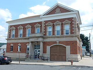
Coaldale is a borough in Schuylkill County, Pennsylvania, United States. Initially settled in 1827, it was incorporated in 1906 from part of the former Rahn Township; it is named for the coal industry—wherein, it was one of the principal early mining centers. Coaldale is in the southern Anthracite Coal region in the Panther Creek Valley, a tributary of the Little Schuylkill River, along which U.S. Route 209 was eventually built between the steep climb up Pisgah Mountain from Nesquehoning (easterly) and its outlet in Tamaqua, approximately five miles to the west.
Shenandoah is a borough in Schuylkill County in the Coal Region of Pennsylvania. It is distinct from Shenandoah Heights, which is part of West Mahanoy Township immediately to the north. As of 2021, the borough's population was 4,247.
Tamaqua is a borough in eastern Schuylkill County in the Coal Region of Pennsylvania, United States. It had a population of 6,934 as of the 2020 U.S. census.
Boswell is a borough in Somerset County, Pennsylvania, United States. It is part of the Johnstown, Pennsylvania Metropolitan Statistical Area. The population was 1,221 at the 2020 census.
Windber is a borough in Somerset County, Pennsylvania, United States, which is located approximately three miles (4.8 km) south of Johnstown. The population was 3,930 at the 2020 census. A former manufacturing town, Windber is part of the Johnstown, Pennsylvania Metropolitan Statistical Area.
Ashland is a borough in Schuylkill County in the U.S. state of Pennsylvania, 15 miles (24 km) northwest of Pottsville. It is part of Northeastern Pennsylvania. A small part of the borough also lies in Columbia County, although all of the population resided in the Schuylkill County portion as of the 2020 census. The borough lies in the anthracite coal region of eastern Pennsylvania. Settled in 1850, Ashland was incorporated in 1857, and was named for Henry Clay's estate near Lexington, Kentucky. The population in 1900 was 6,438, and in 1940, 7,045, but had dropped to 2,471 at the 2020 census.
Anthracite, also known as hard coal and black coal, is a hard, compact variety of coal that has a submetallic lustre. It has the highest carbon content, the fewest impurities, and the highest energy density of all types of coal and is the highest ranking of coals.
The Coal Region is a region of Northeastern Pennsylvania. It is known for being home to the largest known deposits of anthracite coal in the world with an estimated reserve of seven billion short tons.
Byrnesville was a town located in Conyngham Township, Columbia County, Pennsylvania, United States. It was located about halfway between Centralia and Ashland. In 1985, the population of Byrnesville was approximately 75 people living in 29 homes.
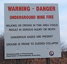
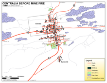
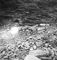
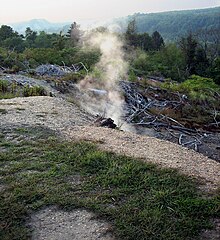
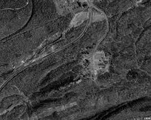
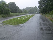
The Centralia mine fire is a coal-seam fire which has been burning in the labyrinth of abandoned coal mines underneath the borough of Centralia, Pennsylvania, United States, since at least May 27, 1962. Its original cause and start date are still a matter of debate. It is burning at depths of up to 300 ft (90 m) over an 8 mi (13 km) stretch of 3,700 acres (15 km2). At its current rate, it could continue to burn for over 250 years. Due to the fire, in the 1980s Centralia was mostly abandoned. There were 1,500 residents at the time the fire is believed to have started, but as of 2017 it has a population of 5 and most of the buildings have been demolished.
The Laurel Run mine fire is an underground mine fire near the communities of Laurel Run and Georgetown, in Luzerne County, Pennsylvania, in the United States. The fire started burning in 1915 at the Red Ash Coal Mine. Attempts to control it lasted from 1915 to 1957 and recommenced in 1966. In the 1960s, the United States government and the Pennsylvania state government became involved in containing the fire. Attempts at stopping the spread of the fire were erroneously declared successful in 1973, and the fire is still burning.
The Carbondale mine fire was a mine fire in the West Side neighborhood of Carbondale, Lackawanna County, Pennsylvania, in the United States. The fire started in 1946, but was eventually contained by the 1970s. However, it caused at least two fatalities and millions of dollars of property damage.
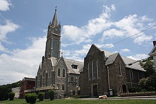
The Assumption of the Blessed Virgin Mary Ukrainian Catholic Church is a Ukrainian Catholic church in the town of Centralia, Pennsylvania. The church is the last remaining church in Centralia, which was largely abandoned after a mine fire rendered much of the town unsafe.
The same individuals have a suit pending in U.S. Middle District Court that alleges the condemnation was part of the commonwealth's plot to obtain mineral rights to the anthracite coal they claim are worth hundreds of millions of dollars.
Despite the inferno below them and the gases that seep into their basements, some Centralians do not want to leave their homes and remain convinced that it's all a plot by coal companies to drive them off valuable land since the borough owns mineral rights to the coal below. (Other rumored villains have variously included anonymous Arabs and large energy cartels.)
Enter 'Centralia borough, Pennsylvania' to search under Community Facts
{{cite web}}
: Missing or empty |title=
(help)