
Salt Lake County is located in the U.S. state of Utah. As of the 2020 United States Census, the population was 1,185,238, making it the most populous county in Utah. Its county seat and largest city is Salt Lake City, the state capital. The county was created in 1850. Salt Lake County is the 37th most populated county in the United States and is one of four counties in the Rocky Mountains to make it into the top 100. Salt Lake County is the only county of the first class in Utah - which under the Utah Code is a county with a population of 700,000 or greater.

Alta is a town in eastern Salt Lake County, Utah, United States. It is part of the Salt Lake City, Utah Metropolitan Statistical Area. The population was 383 at the 2010 census, a slight increase from the 2000 figure of 370.

Cottonwood Heights is a city located in Salt Lake County, Utah, United States, along the east bench of the Salt Lake Valley. It lies south of the cities of Holladay and Murray, east of Midvale, and north of Sandy within the Salt Lake City, Utah Metropolitan Statistical Area. Following a successful incorporation referendum in May 2004, the city was incorporated on January 14, 2005. Cottonwood Heights had been a Census-designated place (CDP) before incorporation. The population as of the 2010 census was 33,433. This is a significant increase over the CDP's 2000 census count of 27,569.

Murray is a city situated on the Wasatch Front in the core of Salt Lake Valley in the U.S. state of Utah. Named for territorial governor Eli Murray, it is the state's fourteenth largest city. According to the 2010 census, Murray has approximately 46,746 residents. Murray shares borders with Taylorsville, Holladay, South Salt Lake and West Jordan, Utah. Once teeming with heavy industry, Murray's industrial sector now has little trace and has been replaced by major mercantile sectors. Known for its central location in Salt Lake County, Murray has been called the Hub of Salt Lake County. Unlike most of its neighboring communities, Murray operates its own police, fire, power, water, library, and parks and recreation departments and has its own school district. While maintaining many of its own services, Murray has one of the lowest city tax rates in the state.

The Wasatch Range or Wasatch Mountains is a mountain range in the western United States that runs about 160 miles (260 km) from the Utah-Idaho border south to central Utah. It is the western edge of the greater Rocky Mountains, and the eastern edge of the Great Basin region. The northern extension of the Wasatch Range, the Bear River Mountains, extends just into Idaho, constituting all of the Wasatch Range in that state.

The Jordan River, in the state of Utah, United States, is a river about 51 miles (82 km) long. Regulated by pumps at its headwaters at Utah Lake, it flows northward through the Salt Lake Valley and empties into the Great Salt Lake. Four of Utah's six largest cities border the river: Salt Lake City, West Valley City, West Jordan and Sandy. More than a million people live in the Jordan Subbasin, which is the part of the Jordan River watershed that lies within Salt Lake and Utah counties. During the Pleistocene, the area was part of Lake Bonneville.
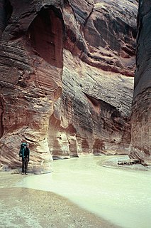
The Paria River is a tributary of the Colorado River, approximately 95 miles (153 km) long, in southern Utah and northern Arizona in the United States. It drains a rugged and arid region northwest of the Colorado, flowing through roadless slot canyons along part of its course.

Snowbird is an unincorporated community in Little Cottonwood Canyon in the Wasatch Range of the Rocky Mountains near Salt Lake City, Utah, United States. It is most famous for Snowbird Ski and Summer Resort, an alpine skiing and snowboarding area, which opened in December 1971.
Little Cottonwood Canyon lies within the Wasatch-Cache National Forest along the eastern side of the Salt Lake Valley, roughly 15 miles from Salt Lake City, Utah. The canyon is part of Granite, a CDP and "Community Council" designated by Salt Lake County. The canyon is a glacial trough, carved by an alpine glacier during the last ice age, 15,000 to 25,000 years ago. A number of rare and endemic plant species are found in the canyon's Albion Basin. Mountain goats inhabit the surrounding mountains.

Solitude Mountain Resort is a ski resort located in the Big Cottonwood Canyon of the Wasatch Mountains, thirty miles southeast of Salt Lake City, Utah. With 66 trails, 1,200 acres (4.9 km2) and 2,047 feet (624 m) vertical, Solitude is one of the smaller ski resorts near Salt Lake City, along with its neighbor Brighton. It is a family-oriented mountain, with a wider range of beginner and intermediate slopes than other nearby ski resorts; 50% of its slopes are graded "beginner" or "intermediate," the highest such ratio in the Salt Lake City area. Solitude was one of the first major US resorts to adopt an RFID lift ticket system, allowing lift lines to move more efficiently. It was followed by Alta Ski Area in 2007. Solitude is adjacent to Brighton Ski Resort near the top of Big Cottonwood Canyon. Solitude and Brighton offer a common "Solbright Pass" which provides access to both resorts for a nominal surcharge.

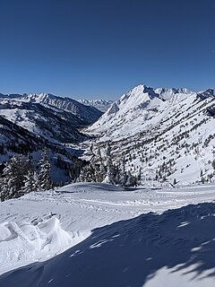
Big Cottonwood Canyon is a canyon in the Wasatch Range 12 miles (19 km) southeast of Salt Lake City in the U.S. state of Utah. The 15-mile (24 km)-long canyon provides hiking, biking, picnicking, rock-climbing, camping and fishing in the summer. Its two ski resorts, Brighton and Solitude, are popular among skiers and snowboarders. The canyon is accessed by The Big Cottonwood Canyon Scenic Byway (SR-190), which runs its length to Guardsman Pass at the top of the canyon, allowing travel to Park City in the summer months.

Bonito Lake is an alpine reservoir located high in the Sierra Blanca mountains northwest of Ruidoso, New Mexico. It is a popular fishing and camping destination, and although it is surrounded by the Lincoln National Forest, it is not a part of the national forest. It is currently owned by the city of Alamogordo, New Mexico as their primary water source. Because of the high altitude, the lake's temperature is cold year round, and is home to an abundance of rainbow trout. The area around the lake has several campgrounds with hiking trails and streams.
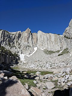
Lone Peak, a mountain peak southeast of Salt Lake City, Utah, United States is the center of the Lone Peak Wilderness, established in 1978. With an elevation of 11,260 feet (3,430 m), it is one of the taller peaks in the Wasatch Range along the Wasatch Front and tends to be a favorite hike. The first person in recorded history to successfully hike Lone Peak was Richard Bell, Sr. of Riverton, Utah. He went on to lead several expeditions and taught the first guides. Lone Peak consists almost entirely of quartz monzonite rock of the 30.5 million year old Little Cottonwood Stock. Quartzite and limestone are also found in distal locations on the mountain. The mountain from Little Cottonwood Canyon on the northern end to Corner Canyon on the southern end is called "Mount Jordan", the highest peak of which is Lone Peak, with other lower peaks being Enniss Peak and Bighorn Peak. The Peak ranks 98th on a list of Utah peaks with 500 feet (150 m) topographic prominence.

The Lone Peak Wilderness is a 30,088-acre (121.76 km2) wilderness area located within the Uinta and the Wasatch-Cache National Forest in the U.S. state of Utah.

The Tushar Mountains are the third highest mountain range in Utah after the Uinta Mountains and the La Sal Range. Located in the Fishlake National Forest, Delano Peak, 12,174 ft NAVD 88, is the highest point in both Beaver and Piute counties and has a prominence of 4,689 ft. Delano Peak is named for Columbus Delano (1809–1896), Secretary of the Interior during the Grant administration. The Tushars receive an ample amount of snow annually even though they are situated within the rainshadow of the Sierra Mountain Range located in California and the Snake Range located in Nevada.

Millcreek Canyon is a canyon in the Wasatch Mountains and part of Millcreek City on the east side of the Salt Lake Valley, Utah. It is a popular recreation area both in the summer and in the winter. It was named by Brigham Young on August 22, 1847 before all of the mills that were built in and below the densely forested canyon. It is home to two restaurants and six Boy Scout Day Camps.

Little Cottonwood Creek is one of the principal streams entering Salt Lake Valley from the east rises near the summit of the Wasatch Mountains a short distance south of the ski resort town of Alta and flows in a westerly direction through Little Cottonwood Canyon until it emerges into Salt Lake Valley about eleven miles from its source thence its course is north westerly through Sandy, Midvale and Murray, Utah until it empties into the Jordan River about six miles south of Salt Lake City. Its whole length is nearly 27 miles (43 km). The headwaters of Little Cottonwood Creek are in Little Cottonwood Canyon, a glaciated canyon in Uinta-Wasatch-Cache National Forest and the Wasatch and Uinta Mountains eco-region. One of the main tributaries of the creek rises in Cecret Lake a small sheet of water situated near Alta. The entire Little Cottonwood Creek drainage basin encompasses 46 square miles (120 km2), ranging in elevation from about 4,490 to 11,500 feet.

Big Cottonwood Creek is one of the largest streams entering Salt Lake Valley from the east from the Wasatch Mountains. The creek flows through the Big Cottonwood Canyon in a westerly direction until it emerges into Salt Lake Valley about eighteen miles (29 km) from its highest source. Thence its course is northwesterly through Cottonwood Heights, Holladay, and Murray, Utah until it empties into the Jordan River about five miles (8.0 km) south of Salt Lake City. In the summer its waters are all used for irrigation purposes. From its source to its original outlet into the Jordan River is a distance of about twenty six miles.
Red Butte Creek is a small stream whose headwaters are found in the northeast part of Salt Lake County, Utah. It flows west through the Red Butte Garden and Arboretum, by the University of Utah, Fort Douglas and flows southwesterly to Salt Lake City’s Liberty Park. Consisting of 7.25 sq mi (18.8 km2) of watershed, Red Butte Canyon is the smallest canyon of the seven canyons in eastern Salt Lake County. Its elevation ranges from 5,000 to 8,000 ft above sea level.
Skiing in Utah is a thriving industry which contributes greatly to the state’s economy. Skiing started off in the state as a recreational activity enjoyed by only a few, but since the 1930s, it has increasingly developed into a substantial industry, which creates thousands of jobs and brings in millions of dollars in revenue.


