Cedar Hill, Missouri

Last updated
Cedar Hill, Missouri
Cedar Hill Dam on Big River in Missouri.JPG
Dam on the Big River at Cedar Hill
Jefferson County Missouri Incorporated and Unincorporated areas Cedar Hill Highlighted.svg
Location of Cedar Hill, Missouri
Coordinates: 38°21′24″N90°37′20″W / 38.35667°N 90.62222°W / 38.35667; -90.62222 Coordinates: 38°21′24″N90°37′20″W / 38.35667°N 90.62222°W / 38.35667; -90.62222
Country United States
State Missouri
County Jefferson
Area
[1]
  Total2.29 sq mi (5.94 km2)
  Land2.29 sq mi (5.94 km2)
  Water0.00 sq mi (0.00 km2)
Elevation
[2]
538 ft (164 m)
Population
 (2020)
  Total1,875
  Density816.99/sq mi (315.42/km2)
Time zone UTC-6 (Central (CST))
  Summer (DST) UTC-5 (CDT)
ZIP code
63016
Area code 636
FIPS code 29-12358 [3]
GNIS feature ID2393369 [2]

Cedar Hill is an unincorporated community and census-designated place (CDP) in northwest Jefferson County, Missouri, United States. The population was 1,721 at the 2010 census. [4]

Contents

History

A post office called Cedar Hill has been in operation since 1868. [5] The community was named for cedar trees near the elevated town site. [6]

Geography

Cedar Hill is located 32 miles (51 km) southwest of downtown St. Louis. Missouri Route 30, a four-lane highway, runs through the western side of the CDP, leading northeast into St. Louis and west 22 miles (35 km) to St. Clair.

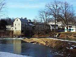
According to the United States Census Bureau, the CDP has a total area of 2.3 square miles (5.9 km2), all land. [4] The Big River, a northward-flowing tributary of the Meramec River, forms the southern and western limits of the CDP, and the community is the site of an old mill and dam.

Demographics

Historical population
CensusPop.Note
2020 1,875
U.S. Decennial Census [7]

As of the census [3] of 2000, there were 1,703 people, 627 households, and 465 families residing in the CDP. The population density was 741.6 inhabitants per square mile (286.3/km2). There were 657 housing units at an average density of 286.1 per square mile (110.5/km2). The racial makeup of the CDP was 97.89% White, 0.06% African American, 0.82% Native American, 0.18% Asian, 0.35% from other races, and 0.70% from two or more races. Hispanic or Latino of any race were 0.82% of the population.

There were 627 households, out of which 38.8% had children under the age of 18 living with them, 56.5% were married couples living together, 11.5% had a female householder with no husband present, and 25.7% were non-families. 19.6% of all households were made up of individuals, and 7.0% had someone living alone who was 65 years of age or older. The average household size was 2.72 and the average family size was 3.11.

In the CDP, the population was spread out, with 27.2% under the age of 18, 9.9% from 18 to 24, 30.0% from 25 to 44, 24.7% from 45 to 64, and 8.2% who were 65 years of age or older. The median age was 35 years. For every 100 females, there were 97.1 males. For every 100 females age 18 and over, there were 95.1 males.

The median income for a household in the CDP was $35,481, and the median income for a family was $43,214. Males had a median income of $40,160 versus $21,074 for females. The per capita income for the CDP was $15,599. About 5.7% of families and 12.9% of the population were below the poverty line, including 6.1% of those under age 18 and 8.8% of those age 65 or over.

Related Research Articles

<span class="mw-page-title-main">Jeddito, Arizona</span> CDP in Navajo County, Arizona

Jeddito is a census-designated place (CDP) in Navajo County, Arizona, United States. The population was 293 at the 2010 census.

<span class="mw-page-title-main">Shongopovi, Arizona</span> CDP in Navajo County, Arizona

Shongopovi is a census-designated place (CDP) in Navajo County, Arizona, United States. It is located on the Second Mesa, within the Hopi Reservation.

<span class="mw-page-title-main">Terra Bella, California</span> Census-designated place in California, United States

Terra Bella is a census-designated place (CDP) in Tulare County, California, United States. The population was 3,310 at the 2010 census, down from 3,466 at the 2000 census.

<span class="mw-page-title-main">High Point, Hernando County, Florida</span> Census-designated place in Florida, United States

High Point is an unincorporated area and census-designated place (CDP) in Hernando County, Florida, United States. The population was 3,686 at the 2010 census.

<span class="mw-page-title-main">Spokane, Missouri</span> Census-designated place in Missouri, United States

Spokane is a census-designated place in Christian County, Missouri, United States. The population was 177 at the 2010 census. It is part of the Springfield, Missouri, Metropolitan Statistical Area.

<span class="mw-page-title-main">Gray Summit, Missouri</span> Census-designated place in Missouri, United States

Gray Summit is an unincorporated community and census-designated place (CDP) in Franklin County, Missouri, United States. The population was 2,701 at the 2010 census. Also called "Gray's Summit", it was founded by Daniel Gray of New York, who built a hotel here in 1845. It is located on Missouri Route 100 just north of Interstate 44.

<span class="mw-page-title-main">Villa Ridge, Missouri</span> Census-designated place in Missouri, United States

Villa Ridge is an unincorporated community and census-designated place (CDP) in Franklin County, Missouri, United States. The population was 2,636 at the 2010 census, up from 2,417 at the 2000 census.

<span class="mw-page-title-main">Murphy, Missouri</span> Census-designated place in Missouri, United States

Murphy is a census-designated place (CDP) in Jefferson County, Missouri, United States. The population was 8,690 at the 2010 census, down from 9,048 in 2000.

<span class="mw-page-title-main">Glasgow Village, Missouri</span> CDP in Missouri, United States

Glasgow Village is a census-designated place (CDP) in St. Louis County, Missouri, United States. The population was 5,429 at the 2010 census.

<span class="mw-page-title-main">Castle Point, Missouri</span> CDP in Missouri, United States

Castle Point is a census-designated place (CDP) in St. Louis County, Missouri, United States. The population was 3,962 at the 2010 census.

<span class="mw-page-title-main">Cedar Glen Lakes, New Jersey</span> Census-designated place in New Jersey, United States

Cedar Glen Lakes is an unincorporated community and census-designated place (CDP) located within Manchester Township, in Ocean County, New Jersey, United States. As of the 2010 United States Census, the CDP's population was 1,421.

<span class="mw-page-title-main">Cedar Glen West, New Jersey</span> Census-designated place in New Jersey, United States

Cedar Glen West is an unincorporated community and census-designated place (CDP) located within Manchester Township, in Ocean County, New Jersey, United States. As of the 2010 United States Census, the CDP's population was 1,267.

<span class="mw-page-title-main">Leisure Knoll, New Jersey</span> Census-designated place in New Jersey, United States

Leisure Knoll is an unincorporated community and census-designated place (CDP) located within Manchester Township, in Ocean County, New Jersey, United States. As of the 2010 United States Census, the CDP's population was 2,490.

<span class="mw-page-title-main">Cedar Crest, New Mexico</span> Census-designated place in New Mexico, United States

Cedar Crest is a census-designated place (CDP) in Bernalillo County, New Mexico, United States. The population was 958 at the 2010 census. It is part of the Albuquerque Metropolitan Statistical Area.

<span class="mw-page-title-main">Cedar Grove, New Mexico</span> CDP in New Mexico, United States

Cedar Grove is a census-designated place (CDP) in Santa Fe County, New Mexico, United States. It is part of the Santa Fe, New Mexico Metropolitan Statistical Area. The population was 747 at the 2010 census.

<span class="mw-page-title-main">Valley Hill, North Carolina</span> Census-designated place in North Carolina, United States

Valley Hill is an unincorporated community and census-designated place (CDP) in Henderson County, North Carolina, United States. The population was 2,070 at the 2010 census. It is part of the Asheville Metropolitan Statistical Area.

<span class="mw-page-title-main">Cedar Crest, Oklahoma</span> CDP in Oklahoma, United States

Cedar Crest is a census-designated place (CDP) in Mayes County, Oklahoma, United States. The population was 312 at the 2010 census, almost unchanged from the figure of 308 recorded in 2000.

<span class="mw-page-title-main">Oak Hills, Oregon</span> Unincorporated community in the state of Oregon, United States

Oak Hills is a census-designated place (CDP) and neighborhood in Washington County, Oregon, United States. The CDP population was 9,050 at the 2000 census. It is on unincorporated land north of Beaverton, west of Cedar Mill, and south/southeast of Bethany. The CDP is roughly bounded by the Sunset Highway on the south, West Union Road on the north, Northwest 174th Avenue on the west, and Northwest 143rd Avenue on the east. The U.S. Postal Service has assigned Beaverton addresses to the area. Fire protection and EMS services are provided through Tualatin Valley Fire and Rescue.

<span class="mw-page-title-main">Clarks Hill, South Carolina</span> CDP in South Carolina, United States

Clarks Hill is a census-designated place (CDP) in McCormick County, South Carolina, United States. The population was 376 at the 2000 census.

<span class="mw-page-title-main">Van Buren (CDP), Maine</span> Census-designated place in Maine, United States

Van Buren is a census-designated place (CDP) comprising the main village within the town of Van Buren in Aroostook County, Maine, United States. The population of the CDP was 1,937 at the 2010 census, out of a population of 2,171 for the entire town.

References

  1. "ArcGIS REST Services Directory". United States Census Bureau. Retrieved August 28, 2022.
  2. 1 2 U.S. Geological Survey Geographic Names Information System: Cedar Hill, Missouri
  3. 1 2 "U.S. Census website". United States Census Bureau . Retrieved 2008-01-31.
  4. 1 2 "Geographic Identifiers: 2010 Census Summary File 1 (G001): Cedar Hill CDP, Missouri". American Factfinder. U.S. Census Bureau. Archived from the original on February 13, 2020. Retrieved August 17, 2018.
  5. "Post Offices". Jim Forte Postal History. Archived from the original on 19 October 2016. Retrieved 18 October 2016.
  6. "Jefferson County Place Names, 1928–1945 (archived)". The State Historical Society of Missouri. Archived from the original on 24 June 2016. Retrieved 19 October 2016.{{cite web}}: CS1 maint: bot: original URL status unknown (link)
  7. "Census of Population and Housing". Census.gov. Retrieved June 4, 2016.