Saint Clair, Missouri

Last updated

Saint Clair
Saint Clair, Missouri
Saint Clair, Missouri (3213600096).jpg
USA Missouri location map.svg
Red pog.svg
Saint Clair
Location within the state of Missouri
Coordinates: 38°20′43″N90°58′52″W / 38.34528°N 90.98111°W / 38.34528; -90.98111 [1]
Country United States
State Missouri
County Franklin
Government
  TypeMunicipality
  MayorCozy Bailey
Area
[2]
  Total4.79 sq mi (12.41 km2)
  Land4.78 sq mi (12.37 km2)
  Water0.01 sq mi (0.03 km2)
Elevation
[1]
699 ft (213 m)
Population
 (2020)
  Total4,791
  Density1,002.93/sq mi (387.22/km2)
Time zone UTC-6 (Central (CST))
  Summer (DST) UTC-5 (CST)
ZIP codes
63077
FIPS code 29-64136
GNIS feature ID2396481 [1]
Interstates I-44 (MO).svg
State highways MO-30.svg MO-47.svg
Website http://stclairmo.us/

Saint Clair is a city in Franklin County, Missouri, United States. The population was 4,791 at the 2020 census.

Contents

Geography

Saint Clair is located between the Meramec River to the southeast and the Bourbeuse River to the northwest. Interstate 44 passes along the northwest side of the city and Missouri Routes 30 and 47 both pass through the city. Union is approximately six miles north along Route 47 and Stanton is about eight miles to the southwest on I-44. Parkway is on Route 30, just southeast of the city. [3]

According to the United States Census Bureau, the city has a total area of 3.71 square miles (9.61 km2), of which 3.70 square miles (9.58 km2) is land and 0.01 square miles (0.03 km2) is water. [4]

History

An early variant name was "Travelers Repose". [1] [5] Saint Clair was platted in 1859 when the railroad was extended to that point. [6] The present name is after a railroad official with the surname St. Clair. [6]

The International Shoe Company Building and Panhorst Feed Store are listed on the National Register of Historic Places. [7]

Demographics

Historical population
CensusPop.Note
1880 217
1890 208−4.1%
1900 189−9.1%
1910 397110.1%
1920 44211.3%
1930 1,135156.8%
1940 1,41024.2%
1950 1,77926.2%
1960 2,71152.4%
1970 2,9789.8%
1980 3,48517.0%
1990 3,91712.4%
2000 4,39012.1%
2010 4,7247.6%
2020 4,7911.4%
U.S. Decennial Census [8]

2010 census

As of the census [9] of 2010, there were 4,724 people, 1,908 households, and 1,136 families living in the city. The population density was 1,276.8 inhabitants per square mile (493.0/km2). There were 2,142 housing units at an average density of 578.9 per square mile (223.5/km2). The racial makeup of the city was 96.9% White, 1.0% African American, 0.3% Native American, 0.1% Asian, 0.3% from other races, and 1.4% from two or more races. Hispanic or Latino of any race were 1.2% of the population.

There were 1,908 households, of which 34.2% had children under the age of 18 living with them, 37.5% were married couples living together, 16.1% had a female householder with no husband present, 5.9% had a male householder with no wife present, and 40.5% were non-families. 33.5% of all households were made up of individuals, and 13.8% had someone living alone who was 65 years of age or older. The average household size was 2.43 and the average family size was 3.11.

The median age in the city was 33.1 years. 26.6% of residents were under the age of 18; 10.6% were between the ages of 18 and 24; 27.1% were from 25 to 44; 23% were from 45 to 64; and 12.8% were 65 years of age or older. The gender makeup of the city was 47.1% male and 52.9% female.

Since 2005 the unemployment rate in St. Clair, Missouri has ranged from 4.4% in April 2007 to 13.3% in January 2009. The current unemployment rate for St. Clair is 6.1% in December 2014.

Statistics found on city-data.com showed that 69.7% of the population completed high school, 6.5% achieved a bachelor's degree, and only 2.5% achieved a graduate degree.

2000 census

As of the census [10] of 2000, there were 4,390 people, 1,765 households, and 1,143 families living in the city. The population density was 1,404.3 inhabitants per square mile (542.2/km2). There were 1,900 housing units at an average density of 607.8 per square mile (234.7/km2). The racial makeup of the city was 97.45% White, 0.75% African American, 0.46% Native American, 0.21% Asian, 0.09% from other races, and 1.05% from two or more races. Hispanic or Latino of any race were 0.71% of the population.

There were 1,765 households, out of which 35.1% had children under the age of 18 living with them, 45.2% were married couples living together, 14.2% had a female householder with no husband present, and 35.2% were non-families. 30.4% of all households were made up of individuals, and 14.0% had someone living alone who was 65 years of age or older. The average household size was 2.44 and the average family size was 3.05.

In the city, the population was spread out, with 27.9% under the age of 18, 10.8% from 18 to 24, 29.6% from 25 to 44, 18.0% from 45 to 64, and 13.7% who were 65 years of age or older. The median age was 32 years. For every 100 females, there were 88.5 males. For every 100 females age 18 and over, there were 82.5 males.

The median income for a household in the city was $35,716, and the median income for a family was $41,939. Males had a median income of $35,509 versus $23,986 for females. The per capita income for the city was $18,101. About 8.6% of families and 10.6% of the population were below the poverty line, including 10.2% of those under age 18 and 10.1% of those age 65 or over.

Education

The St. Clair School District covers the area of St. Clair and some of the surrounding areas. The district consists of four schools: [11] St. Clair High School, St. Clair Junior High School, St. Clair Edgar Murray Elementary School, and St. Clair Elementary. Other schools include Cornerstone Christian Academy.

St. Clair has a public library, a branch of the Scenic Regional Library system. [12]

Notable person

National Register of Historic Places

Related Research Articles

<span class="mw-page-title-main">St. Clair County, Missouri</span> County in Missouri, United States

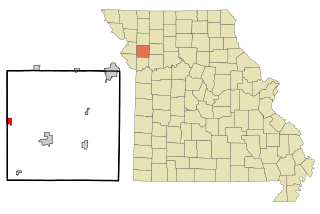
St. Clair County is a county located in the western portion of the U.S. state of Missouri. As of the 2020 census, the population was 9,284. Its county seat is Osceola. The largest city is Appleton City. The county was organized in 1841 and named after General Arthur St. Clair, Governor of the Northwest Territory. St. Clair was also the 9th president of the United States in Congress Assembled. Under his presidency, the Northwest Ordinance and United States Constitution were passed.

<span class="mw-page-title-main">Missouri Valley, Iowa</span> City in Iowa, United States

Missouri Valley is a city in Harrison County, Iowa, United States. The population was 2,678 at the time of the 2020 census.

<span class="mw-page-title-main">China Township, Michigan</span> Charter township in Michigan, United States

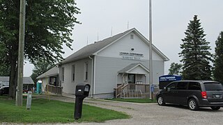
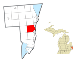
China Township is a charter township of St. Clair County in the U.S. state of Michigan. The population was 3,551 at the 2010 Census. It is named after China, Maine.

<span class="mw-page-title-main">Marine City, Michigan</span> City in Michigan, United States

Marine City is a city in St. Clair County in the U.S. state of Michigan. Located on the west bank of the St. Clair River, it is one of the cities in the River District north of Detroit and south of Lake Huron. In the late 19th century, it was a major center of wooden shipbuilding and lumber processing.

<span class="mw-page-title-main">St. Clair Township, Michigan</span> Civil township in Michigan, United States

St. Clair Township is a civil township of St. Clair County in the U.S. state of Michigan. The population was 6,817 at the 2010 Census. The city of St. Clair is located near the southeast corner of the township.

<span class="mw-page-title-main">St. Clair, Minnesota</span> City in Minnesota, United States

St. Clair or Saint Clair is a city in Blue Earth County, Minnesota, United States, located along the Le Sueur River. The population was 750 at the 2020 census. It is part of the Mankato-North Mankato Metropolitan Statistical Area.

<span class="mw-page-title-main">Harrisonville, Missouri</span> City in Missouri, United States

Harrisonville is a city in Cass County, Missouri, United States. The population was 10,121 at the 2020 census. It is the county seat of Cass County. It is part of the Kansas City metropolitan area.

<span class="mw-page-title-main">Washington, Missouri</span> City in Missouri, United States

Washington is a city on the south banks of the Missouri River, 50 miles west of St. Louis, Missouri, and the largest in Franklin County, Missouri, United States. The estimated population in July 2021 was 14,916, an increase of 7% since the 2010 census. It is the corncob pipe capital of the world, with Missouri Meerschaum located on the riverfront.

<span class="mw-page-title-main">Murphy, Missouri</span> Census-designated place in Missouri, United States

Murphy is a census-designated place (CDP) in Jefferson County, Missouri, United States. The population was 8,690 at the 2010 census, down from 9,048 in 2000.

<span class="mw-page-title-main">Skidmore, Missouri</span> City in Missouri, United States

Skidmore is a city in western Nodaway County, Missouri, United States. The population was 245 at the 2020 Census. The small farming community is known for the unsolved extrajudicial killing of Ken Rex McElroy, the murders of Wendy Gillenwater and Bobbie Jo Stinnett, and the disappearance of Branson Perry. Skidmore also has a yearly "Punkin' Show."

<span class="mw-page-title-main">Appleton City, Missouri</span> City in Missouri, United States

Appleton City is a city in St. Clair County, Missouri, United States. The population was 1,032 as of the 2020 census. It is the largest city in St. Clair County.

<span class="mw-page-title-main">Lowry City, Missouri</span> City in Missouri, United States

Lowry City is a city in St. Clair County, Missouri, United States. The population was 613 at the 2020 census. Lowry City is the city where the Ozark Mountains meet the Great Plains.

<span class="mw-page-title-main">Osceola, Missouri</span> City in Missouri, United States

Osceola is a city in St. Clair County, Missouri, United States. The population was 909 at the 2020 census. It is the county seat of St. Clair County. During the American Civil War, Osceola was the site of the Sacking of Osceola.

<span class="mw-page-title-main">Roscoe, Missouri</span> Village in Missouri, United States

Roscoe is a village in St. Clair County, Missouri, United States. The population was 89 at the 2020 census.

<span class="mw-page-title-main">Olivette, Missouri</span> City in Missouri, United States

Olivette is an inner-ring suburb of St. Louis, located in St. Louis County, Missouri, United States. The population was 8,504 at the 2020 census.

<span class="mw-page-title-main">Overland, Missouri</span> City in Missouri, United States

Overland is a city in St. Louis County, Missouri, United States. The population was 16,062 at the 2010 census.

<span class="mw-page-title-main">Nevada, Missouri</span> City in Missouri, United States

Nevada is a city in and the county seat of Vernon County, Missouri, United States. The population was 8,386 at the 2010 census, and 8,254 in the 2018 estimate. The local government has a council-manager model.

<span class="mw-page-title-main">St. Ann, Missouri</span> City in Missouri, United States

St. Ann or Saint Ann is a city in northwest St. Louis County, Missouri, United States. The population was 13,019 at the 2020 census.

<span class="mw-page-title-main">Gower, Missouri</span> City in Missouri, United States

Gower is a city in Buchanan and Clinton counties in the U.S. state of Missouri and is part of the Kansas City metropolitan area. The population was 1,533 at the 2020 census.

<span class="mw-page-title-main">St. Paul, Missouri</span> City in Missouri, United States

St. Paul is a city in St. Charles County, Missouri, United States. The population was 1,829 at the 2010 census.

References

  1. 1 2 3 4 U.S. Geological Survey Geographic Names Information System: Saint Clair, Missouri
  2. "ArcGIS REST Services Directory". United States Census Bureau. Retrieved August 28, 2022.
  3. Missouri Atlas & Gazetteer, DeLorme, 2007, Third edition, pp. 40 and 48 ISBN   0-89933-353-2
  4. "US Gazetteer files 2010". United States Census Bureau. Archived from the original on January 25, 2012. Retrieved July 8, 2012.
  5. Wallis, Michael. Route 66: The Mother Road. New York: St. Martin's. p. 62. ISBN   0-312-08285-1.
  6. 1 2 "Franklin County Place Names, 1928–1945 (archived)". The State Historical Society of Missouri. Archived from the original on June 24, 2016. Retrieved October 1, 2016.{{cite web}}: CS1 maint: bot: original URL status unknown (link)
  7. "National Register Information System". National Register of Historic Places . National Park Service. July 9, 2010.
  8. "Census of Population and Housing". Census.gov. Retrieved June 4, 2015.
  9. "U.S. Census website". United States Census Bureau . Retrieved July 8, 2012.
  10. "U.S. Census website". United States Census Bureau . Retrieved January 31, 2008.
  11. St. Clair R-XIII School District
  12. "Locations and Hours". Scenic Regional Library. Retrieved June 2, 2019.