
Saline County is located along the Missouri River in the U.S. state of Missouri. As of the 2010 census, the population was 23,370. Its county seat is Marshall. The county was established November 25, 1820, and named for the region's salt springs.

Pettis County is a county located in west central U.S. state of Missouri. As of the 2010 census, the population was 42,201. Its county seat is Sedalia. The county was organized January 24, 1833, and named after former U.S. Representative Spencer Darwin Pettis.

Newton County is a county located in the southwest portion of the U.S. state of Missouri. As of the 2010 census, the population was 58,114. Its county seat is Neosho. The county was organized in 1838 and is named in honor of John Newton, a hero who fought in the Revolutionary War.

Miller County is a county located in the U.S. state of Missouri. As of the 2010 census, the population was 24,748. Its county seat is Tuscumbia. The county was organized February 6, 1837 and named for John Miller, former U.S. Representative and Governor of Missouri.

Laclede County is a county located in the U.S. state of Missouri. As of the 2010 census, the population was 35,571. Its county seat is Lebanon. The county was organized February 24, 1849, and was named after Pierre Laclède, founder of St. Louis.

Jefferson County is located in the eastern portion of the state of Missouri. It is a part of the St. Louis Metropolitan Area. As of the 2010 census, the population was 218,733, making it the sixth-most populous county in Missouri. Its county seat is Hillsboro. The county was organized in 1818 and named in honor of former president Thomas Jefferson.

Franklin County is located in the U.S. state of Missouri. As of the 2010 census, the population was 101,492. Its county seat is Union. The county was organized in 1818 and is named after Founding Father Benjamin Franklin.

Cole County is a county located in the central part of the U.S. state of Missouri. As of the 2020 census, its population was 77,279. Its county seat and largest city is Jefferson City, the state capital. The county was organized November 16, 1820 and named after pioneer Captain Stephen Cole, an Indian fighter and pioneer settler, who built Cole's Fort in Boonville.

Camden County is a county located in the U.S. state of Missouri. As of the 2020 Census, the population was 42,745. Its county seat is Camdenton. The county was organized on January 29, 1841, as Kinderhook County and renamed Camden County in 1843 after Charles Pratt, 1st Earl Camden, Lord Chancellor of the United Kingdom and leader of the British Whig Party.

Butler County is a county located in the southeast Ozark Foothills Region in the U.S. state of Missouri. As of the 2020 Census, the county's population was 42,130. The largest city and county seat is Poplar Bluff. The county was officially organized from Wayne County on February 27, 1849, and is named after former U.S. Representative William O. Butler (D-Kentucky), who was also an unsuccessful candidate for Vice President of the United States. The first meeting in the Butler County Courthouse was held on June 18, 1849.

Jefferson County, Arkansas is a county located in the U.S. state of Arkansas in the area known as the Arkansas Delta, that extends west of the Mississippi River. As of the 2010 census, the population was 77,435. Its county seat and largest city is Pine Bluff. Jefferson County is Arkansas's 21st county, formed on November 2, 1829, from portions of Arkansas and Pulaski counties, and named for Thomas Jefferson, third President of the United States. Jefferson County is included in the Pine Bluff, Arkansas Metropolitan Statistical Area. The county is bisected by the Arkansas River, which was critical to its development and long the chief transportation byway.
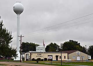
Fisk is a small city in Butler County, Southeast Missouri, United States. It is located right along the Butler-Stoddard County line on U.S. Route 60, along the St. Francis River. The population was 312 at the 2020 census.

New Haven is a city in Franklin County, Missouri, United States. The population was 2,089 at the 2010 census.

Pacific is a city in the U.S. state of Missouri in eastern Franklin County and extending to the east into southwest St. Louis County. The population was 7,002 at the 2010 census.

Success is an unincorporated community in Texas County, Missouri, United States. It is located approximately twelve miles northwest of Houston at the southern intersection of Routes 17 and 32.
St. Albans is an unincorporated community in northeastern Franklin County, Missouri, United States. It lies approximately five miles northeast of Labadie and about seven miles west of Wildwood. St. Albans is above the Missouri River floodplain. The town borders a small section of St. Charles County which, unlike the rest of the county, lies on the south side of the Missouri River.
Edwards is an unincorporated community in southeastern Benton County, Missouri, United States. It is located on Route 7, approximately sixteen miles (26 km) southeast of Warsaw. Edwards is a 16-minute drive from Climax Springs and is at an elevation of 791 feet (241 m).
Broseley is an unincorporated community in eastern Butler County, Missouri, United States. It is located on Missouri Route 51, approximately ten miles southeast of Poplar Bluff. Nyssa is two miles to the south and Batesville is two miles to the north.
Sylvania is an unincorporated community in northwest Dade County, Missouri, United States. Sylvania is located at the intersection of Missouri routes D and E, south of Jerico Springs. The Stony Point Prairie Conservation Area lies just to the north along route D.
Champion City is an unincorporated community in southwest Franklin County in the U.S. state of Missouri.

