New Haven, Missouri

Last updated

New Haven, Missouri
Central Hotel New Haven MO.jpg
Nickname: 
sun drop country
Franklin County Missouri Incorporated and Unincorporated areas New Haven Highlighted.svg
Location of New Haven, Missouri
Coordinates: 38°36′17″N91°13′04″W / 38.60472°N 91.21778°W / 38.60472; -91.21778 [1]
Country United States
State Missouri
County Franklin
Area
[2]
  Total3.38 sq mi (8.75 km2)
  Land3.21 sq mi (8.32 km2)
  Water0.16 sq mi (0.42 km2)
Elevation
[1]
669 ft (204 m)
Population
 (2020)
  Total2,414
  Density751.32/sq mi (290.12/km2)
Time zone UTC-6 (Central (CST))
  Summer (DST) UTC-5 (CDT)
ZIP code
63068
Area code 573
FIPS code 29-51914 [3]
GNIS feature ID2395200 [1]
Website www.newhavenmo.org

New Haven is a city in Franklin County, Missouri, United States. The population was 2,414 as of the 2020 census.

Contents

New Haven is within the Hermann AVA (American Viticultural Area).

History

New Haven was originally called Miller's Landing, and under the latter name was platted in 1855. [4] A post office called New Haven has been in operation since 1858. [5]

The AME Church of New Haven, New Haven Commercial Historic District, New Haven Residential Historic District, Wilhelm Pelster House-Barn, and Christopher and Johanna Twelker Farm are listed on the National Register of Historic Places. [6] [7]

One notable resident of the New Haven area was Herman Otten (b.1933, d. 2019), pastor of Trinity Lutheran for 55 years. [8] He was the editor of Beck's American Translation and of the Christian News weekly paper. [9]

Geography

The city is located in northwest Franklin County above the Missouri River Valley. Missouri Route 100 is on the south side of the city. Hermann is approximately 13 miles to the northwest and Washington is 11 miles to the east. [10]

According to the United States Census Bureau, the city has a total area of 3.45 square miles (8.94 km2), of which 3.29 square miles (8.52 km2) is land and 0.16 square miles (0.41 km2) is water. [11]

Demographics

Historical population
CensusPop.Note
1880 471
1890 76762.8%
1900 88315.1%
1910 855−3.2%
1920 805−5.8%
1930 8768.8%
1940 1,00214.4%
1950 1,0090.7%
1960 1,22321.2%
1970 1,47420.5%
1980 1,5817.3%
1990 1,75711.1%
2000 1,8676.3%
2010 2,08911.9%
2020 2,41415.6%
U.S. Decennial Census [12]

2010 census

As of the census [13] of 2010, there were 2,089 people, 818 households, and 533 families living in the city. The population density was 635.0 inhabitants per square mile (245.2/km2). There were 905 housing units at an average density of 275.1 per square mile (106.2/km2). The racial makeup of the city was 95.1% White, 0.7% African American, 0.6% Native American, 0.3% Asian, 1.7% from other races, and 1.6% from two or more races. Hispanic or Latino of any race were 2.1% of the population.

There were 818 households, of which 34.8% had children under the age of 18 living with them, 49.6% were married couples living together, 10.6% had a female householder with no husband present, 4.9% had a male householder with no wife present, and 34.8% were non-families. 30.9% of all households were made up of individuals, and 14% had someone living alone who was 65 years of age or older. The average household size was 2.45 and the average family size was 3.08.

The median age in the city was 36.5 years. 25.9% of residents were under the age of 18; 7.6% were between the ages of 18 and 24; 25.9% were from 25 to 44; 24% were from 45 to 64; and 16.7% were 65 years of age or older. The gender makeup of the city was 46.6% male and 53.4% female.

2000 census

As of the census [3] of 2000, there were 1,867 people, 707 households, and 485 families living in the city. The 2010 population has risen to 2,089. The population density was 654.2 inhabitants per square mile (252.6/km2). There were 778 housing units at an average density of 272.6 per square mile (105.3/km2). The racial makeup of the city was 98.02% White, 0.64% African American, 0.27% Native American, and 1.07% from two or more races. Hispanic or Latino of any race were 0.86% of the population.

There were 707 households, out of which 35.4% had children under the age of 18 living with them, 56.0% were married couples living together, 8.9% had a female householder with no husband present, and 31.3% were non-families. 28.6% of all households were made up of individuals, and 13.9% had someone living alone who was 65 years of age or older. The average household size was 2.54 and the average family size was 3.13.

In the city, the population was spread out, with 27.3% under the age of 18, 8.0% from 18 to 24, 29.0% from 25 to 44, 18.6% from 45 to 64, and 17.0% who were 65 years of age or older. The median age was 35 years. For every 100 females, there were 86.1 males. For every 100 females age 18 and over, there were 80.7 males.

The median income for a household in the city was $36,681, and the median income for a family was $45,260. Males had a median income of $35,161 versus $21,108 for females. The per capita income for the city was $16,503. About 2.6% of families and 4.7% of the population were below the poverty line, including 2.4% of those under age 18 and 7.6% of those age 65 or over.

Education

New Haven School District operates one elementary school, one middle school and New Haven High School. [14]

New Haven has a public library, a branch of the Scenic Regional Library system. [15]

Related Research Articles

<span class="mw-page-title-main">Wheaton, Missouri</span> City in Missouri, United States

Wheaton is a city in Wheaton Township, Barry County, Missouri, United States. The population was 696 at the 2010 census.

<span class="mw-page-title-main">Harrisonville, Missouri</span> City in Missouri, United States

Harrisonville is a city in Cass County, Missouri, United States. The population was 10,121 at the 2020 census. It is the county seat of Cass County. It is part of the Kansas City metropolitan area.

<span class="mw-page-title-main">Liberty, Missouri</span> City in Missouri, United States

Liberty is a city in and the county seat of Clay County, Missouri, United States and is a suburb of Kansas City, located in the Kansas City Metropolitan Area. As of the 2020 United States Census the population was 30,167. Liberty is home to William Jewell College.

<span class="mw-page-title-main">Smithville, Missouri</span> City in Missouri, United States

Smithville is a city in Clay and Platte counties in the U.S. state of Missouri and is part of the Kansas City metropolitan area, along the Little Platte River. The population was 10,406 at the 2020 United States Census.

<span class="mw-page-title-main">Washington, Missouri</span> City in the United States

Washington is a city on the south banks of the Missouri River, 50 miles west of St. Louis, Missouri, and the largest in Franklin County, Missouri, United States. The estimated population in July 2022 was 15,075, which is an increase of 3.97% since the 2020 U.S. census. It is notable for being the "corncob pipe capital of the world," with Missouri Meerschaum located on the riverfront.

<span class="mw-page-title-main">Lebanon, Missouri</span> City in Missouri, United States

Lebanon is a city in and the county seat of Laclede County in Missouri. The population was 14,474 at the time of the 2010 census. It is the county seat of Laclede County. The Lebanon Micropolitan Statistical Area consists of Laclede County.

<span class="mw-page-title-main">Linneus, Missouri</span> City in Missouri, United States

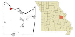
Linneus is a small city in Linn County, Missouri, United States. The population was 281 at the 2020 census. It is the county seat of Linn County.

<span class="mw-page-title-main">New Cambria, Missouri</span> City in Missouri, United States

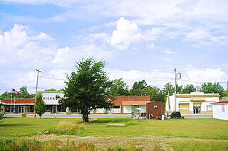
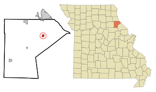
New Cambria is a city in Macon County, Missouri, United States. The population was 153 at the 2020 census, down from 195 in 2010.

<span class="mw-page-title-main">Lilbourn, Missouri</span> City in Missouri, United States

Lilbourn is a city in New Madrid County, Missouri, United States. The population was 994 at the 2020 census.

<span class="mw-page-title-main">Chamois, Missouri</span> City in Missouri, United States

Chamois is a city in Osage County, Missouri, United States. The population was 377 at the 2020 census. It is part of the Jefferson City, Missouri Metropolitan Statistical Area.

<span class="mw-page-title-main">Bolivar, Missouri</span> City in Missouri, United States

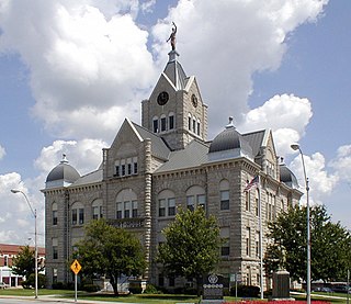
Bolivar is a city and county seat of Polk County, Missouri, United States.

<span class="mw-page-title-main">New London, Missouri</span> City in Missouri, United States

New London is a city in Ralls County, Missouri, United States. The population was 943 at the 2020 census. It is the county seat of Ralls County.

<span class="mw-page-title-main">Miami, Missouri</span> City in Missouri, United States

Miami is a city in Saline County, Missouri, United States. The population was 175 at the 2010 census.

<span class="mw-page-title-main">Park Hills, Missouri</span> City in Missouri, United States

Park Hills is a city in St. Francois County, Missouri, United States. The population was 8,587 at the 2020 census.

<span class="mw-page-title-main">Grantwood Village, Missouri</span> Town in Missouri, United States

Grantwood Village is a town in St. Louis County, Missouri, United States. The population was 863 at the 2010 census.

<span class="mw-page-title-main">Pasadena Hills, Missouri</span> City in Missouri, United States

Pasadena Hills is a city in St. Louis County, Missouri, United States. The population was 930 at the 2010 census. The entire city is listed on the National Register of Historic Places.

<span class="mw-page-title-main">Puxico, Missouri</span> City in Missouri, United States

Puxico is a city in Stoddard County, Missouri, United States. The population was 881 at the 2010 census.

<span class="mw-page-title-main">Schell City, Missouri</span> City in Missouri, United States

Schell City is a city in northeast Vernon County, Missouri, United States. The population was 249 at the 2010 census.

<span class="mw-page-title-main">New Franklin, Missouri</span> City in Missouri, United States

New Franklin is a city in Howard County, Missouri, United States. The population was 1,027 at the 2020 census. It is part of the Columbia, Missouri Metropolitan Statistical Area.

<span class="mw-page-title-main">Moscow Mills, Missouri</span> Town in Missouri, US

Moscow Mills is a city in Lincoln County, Missouri, United States. The population was 2,509 at the 2010 census.

References

  1. 1 2 3 U.S. Geological Survey Geographic Names Information System: New Haven, Missouri
  2. "ArcGIS REST Services Directory". United States Census Bureau. Retrieved August 28, 2022.
  3. 1 2 "U.S. Census website". United States Census Bureau . Retrieved January 31, 2008.
  4. "Franklin County Place Names, 1928–1945 (archived)". The State Historical Society of Missouri. Archived from the original on June 24, 2016. Retrieved September 30, 2016.{{cite web}}: CS1 maint: bot: original URL status unknown (link)
  5. "Post Offices". Jim Forte Postal History. Retrieved September 30, 2016.
  6. "National Register Information System". National Register of Historic Places . National Park Service. July 9, 2010.
  7. "National Register of Historic Places Listings". Weekly List of Actions Taken on Properties: 10/31/16 through 11/04/16. National Park Service. November 10, 2016.
  8. Trinity, New Haven website, see also Pastor Herman Otten leaving Trinity Lutheran Church after 55 years, by Kyle Quick, New Haven Banner
  9. Herman Otten: The Man Behind Christian News, Interview Response by William Harley, 27 November 2009, WLS Essays, 11 pp.
  10. Missouri Atlas & Gazetteer, DeLorme, 2007, Third edition, p. 39, ISBN   0-89933-353-2
  11. "US Gazetteer files 2010". United States Census Bureau. Archived from the original on January 25, 2012. Retrieved July 8, 2012.
  12. "Census of Population and Housing". Census.gov. Retrieved June 4, 2015.
  13. "U.S. Census website". United States Census Bureau . Retrieved July 8, 2012.
  14. "New Haven School District". Great Schools. Retrieved June 2, 2019.
  15. "Locations and Hours". Scenic Regional Library. Retrieved June 2, 2019.

I