The Boston Post Road was a system of mail-delivery routes between New York City and Boston, Massachusetts, that evolved into one of the first major highways in the United States.

Waltham is a city in Middlesex County, Massachusetts, United States, and was an early center for the labor movement as well as a major contributor to the American Industrial Revolution. The original home of the Boston Manufacturing Company, the city was a prototype for 19th century industrial city planning, spawning what became known as the Waltham-Lowell system of labor and production. The city is now a center for research and higher education, home to Brandeis University and Bentley University as well as industrial powerhouse Raytheon Technologies. The population was 65,218 at the census in 2020.

Newton is a city in Middlesex County, Massachusetts, United States. It is approximately 7 miles (11 km) west of downtown Boston. Newton comprises a patchwork of thirteen villages without a city center. At the 2020 U.S. census, the population of Newton was 88,923.

Auburndale is one of the thirteen villages within the city of Newton in Middlesex County, Massachusetts, United States. It lies at the western end of Newton near the intersection of interstate highways 90 and 95. It is bisected by the Massachusetts Turnpike. Auburndale is surrounded by three other Newton villages as well as the city of Waltham and the Charles River. Auburndale is the home of Williams and Burr elementary schools, as well as Lasell College. Auburndale Square is the location of the Plummer Memorial Library, which is run by the Auburndale Community Library and no longer affiliated with the Newton Free Library, the Turtle Lane Playhouse, and many small businesses.
The Middlesex and Boston Street Railway (M&B) was a streetcar and later bus company in the area west of Boston. Streetcars last ran in 1930, and in 1972, the company's operations were merged into the Massachusetts Bay Transportation Authority (MBTA).
Washington Street is a street originating in downtown Boston, Massachusetts, which extends southwestward to the Massachusetts–Rhode Island state line. The majority of its length outside of the city was built as the Norfolk and Bristol Turnpike in the early 19th century. It is the longest street in Boston and remains one of the longest streets in the Commonwealth of Massachusetts. Due to various municipal annexations with the city of Boston, the name Washington Street now exists 6 or more times within the jurisdiction(s) of the City of Boston.
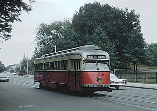
The A branch or Watertown Line was a streetcar line in the Boston, Massachusetts, area, operating as a branch of the Massachusetts Bay Transportation Authority Green Line. The line ran from Watertown through Newton Corner, Brighton, and Allston to Kenmore Square, then used the Boylston Street subway and Tremont Street subway to reach Park Street station.

Commonwealth Avenue is a major street in the cities of Boston and Newton, Massachusetts. It begins at the western edge of the Boston Public Garden, and continues west through the neighborhoods of the Back Bay, Kenmore Square, Boston University, Allston, Brighton and Chestnut Hill. It continues as part of Route 30 through Newton until it crosses the Charles River at the border of the town of Weston.

Newtonville is one of the thirteen villages within the city of Newton in Middlesex County, Massachusetts, United States.

The Second Church in Newton, United Church of Christ, is located at 60 Highland Street in West Newton, a village of Newton, Massachusetts. This church is rooted in the Congregational denomination, welcomes all visitors, and does not require uniformity of belief. Its present church building, a Gothic Victorian structure designed by architects Allen & Collens and completed in 1916, was listed in the National Register of Historic Places in 1990.

Newtonville station is a commuter rail station on the MBTA Commuter Rail Framingham/Worcester Line, located between the Massachusetts Turnpike and Washington Street at Newtonville Square in the village of Newtonville in Newton, Massachusetts. Stairway entrances are located on the bridges over the Turnpike at Walnut Street and Harvard Street. Newtonville station is not accessible; renovations for accessibility are planned.

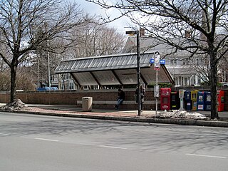
Auburndale station is an MBTA Commuter Rail station in Auburndale, Massachusetts. It serves the Framingham/Worcester Line. It is located next to the Massachusetts Turnpike near Lasell College. The modern station platform, built around 1961, replaced a highly acclaimed 1881 depot building designed by H. H. Richardson. A full renovation of the station for accessibility is planned.

Waltham station is an MBTA Commuter Rail station in Waltham, Massachusetts. It serves the Fitchburg Line. It is located in downtown Waltham adjacent to Central Square. The station is the transit hub of Waltham, with MBTA bus routes 61, 70, 553, 554, 556, and 558 stopping on Carter Street adjacent to the station.

The Newtonville Historic District is a historic district in the village of Newtonville, in Newton, Massachusetts. The district encompasses the southern portion of the village's business district, as well as surrounding residential areas. It was listed on the National Register of Historic Places in 1986, and enlarged in 1990.

The Central Congregational Church is an historic church building located at 218 Walnut Street, in the village of Newtonville in Newton, Massachusetts. Built in 1895, it is the only ecclesiastical work in the city by the noted Boston architects Hartwell and Richardson, and one of its finest examples of Romanesque architecture. The building was listed on the National Register of Historic Places in 1986. Since September 7, 2003, it has been the Newton Campus of the Boston Chinese Evangelical Church.

The Charles River Reservation Parkways are parkways that run along either side of the Charles River in eastern Massachusetts. The roads are contained within the Charles River Reservation and the Upper Charles River Reservation, and fall within a number of communities in the greater Boston metropolitan area. The Charles River parks extend from the Charles River Dam, where the Charles empties into Boston Harbor, to Riverdale Park in the West Roxbury neighborhood of Boston. Most of the roadways within the parks are listed on the National Register of Historic Places as a unit, although Storrow Drive and Memorial Drive are listed as part of the Charles River Basin Historic District.

Hartwell and Richardson was a Boston, Massachusetts architectural firm established in 1881, by Henry Walker Hartwell (1833–1919) and William Cummings Richardson (1854–1935). The firm contributed significantly to the current building stock and architecture of the greater Boston area. Many of its buildings are listed on the National Register of Historic Places.
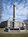
Newton Corner is an MBTA bus transfer point in the Newton Corner neighborhood of Newton, Massachusetts, located on the rotary where Washington Street crosses the Massachusetts Turnpike. The Newton Corner station, known simply as Newton for much of its lifetime, served commuters on the Worcester Line from 1834 to 1959. A streetcar stop, located on the surface streets, served a number of routes beginning in 1863, including the Green Line A branch until 1969. Newton Corner is now a stop and transfer point for MBTA routes 52, 57, 501, 504, 553, 554, 556, and 558, which include express routes to downtown Boston as well as local routes, with stops on the north and south sides of the rotary.