Cervantes, officially the Municipality of Cervantes (Ilocano: Ili ti Cervantes; Filipino: Bayan ng Cervantes), is a 4th class municipality in the province of Ilocos Sur, Philippines. According to the 2020 census, it has a population of 19,449 people.[3]
The municipality is officially the Summer Capital of Ilocos Sur. It has a relatively cooler climate than most of lowland Ilocos Sur due to its geographical location and proximity to Mountain Province and Benguet. The municipality is home to the Bessang Pass Natural Monument.
Etymology
The origin of the name is unknown or undocumented but it is believed that it was named after the famous poet Miguel de Cervantes. But the town's history was tied to the poet's name and the people living on the town adopted it as their own official name.
The earliest known historical document about Cervantes was that, it started as a small Igorot Village known as “Mantamang”, an Igorot word meaning “to look over”. Igorot traders and Chinese merchants who always had to pass the village frequently used man and horse trails connecting the lowland and upland neighboring localities.
On March 4, 1879, the residents of Mantamang petitioned that the village be recognized as a Christian town under the district of Lepanto-Amburayan. The town was given the name Cervantes and that remained the name of the town up to the present.
Maximo Lilio de Garcia has written that Cervantes was formerly a barrio when it was founded by the Spanish colonizers. It started with only thirty houses made of light building materials like bamboo and cogon. In spite of the fertile lands that abound the place the native used to cultivate only small patches of rice fields, which made the barrio unprogressive.
Lilio further stated that Cervantes has a distance of 24 kilometers from Lepanto. The system of communication was maintained on a weekly basis due to its poor road that traversed the sloppy mountains zigzagging upward the hills back of Cayus where the storage house was located and down to the lowlands reaching the Malaya River, which sometimes overflow during rainy season making the trail slippery.
During the Spanish Era, a portion of the land near the Abra River bank was used as a penal colony by the Spanish soldiers who brought with them the Ilocanos from the lowlands. In 1883, a malaria epidemic affected the colony prompting the Spanish officials to move to the upland, which is now the present location of the town proper. The delivery of 5,000 grams of quinine ended the epidemic.
At that time, the barrio was founded between Abra and Malaya Rivers, the inhabitants were distributed among the three rancherias. The first settlement was established on an elevated healthful well-ventilated place, where a small house for the children of the neighboring barrios, a storage building for tobacco and barracks were constructed. Springs were the source of potable clean and abundant water supply. The natives cultivated and produced vegetables and fruits suitable to the climate. Coffee was produced on the land annexed to the commendancia.
The next group of settlement founded a rancheria less than a half-kilometer distance from the first settlement. This time better types of houses were built with an estimated population of 819 residents migrating from other rancherias and barrios of Mailac Cambaguio and Magucmay. Then another small community was developed with both sections of Cervantes where a spacious administrative building, other ruinous edifices and barracks built of wood for the civil guards, were located.
Gradually, the original Igorot settlers were displaced and forced to move to the hills and mountains. This explains why at present, Igorot are mostly settled in far-flung barrios, while the Ilocanos, mestizos and those who intermarried with Chinese, Spaniards, Americans and other foreigners populate the central area of the municipality.
The constantly growing of trade in the area made it necessary that it should have a good outlet to the coast. A road was built from Cervantes going west over the Malaya Range exiting at the town of Tagudin, Ilocos Sur. This road was later improved and widened and became passable all the way to Bontoc.
During American rule, the Philippine Commission passed Act No. 410 and Sec. 1 of said act consolidated the Commandancias of Lepanto, Bontoc and Amburayan, together with territory lying between the boundaries of Abra, Cagayan and Bontoc into the Province of Lepanto-Bontoc. This province as divided into three sub-provinces corresponding to the territory of the former comandancias. Cervantes was made the seat of government of Amburayan sub-province. Its military governor was William Dinwiddie.
Later on, Cervantes became a pueblo by virtue of Act No. 441 of the Philippine Commission, which established local civil government in the townships and settlements of Lepanto-Bontoc. And in 1907, Cervantes was transferred to the Province of Ilocos Sur by virtue of the provisions of Act No. 1646, passed by the Philippines Commission on May 15, 1907, providing for the transfer of all sub-provinces of Amburayan and large sections of Lepanto and Benguet to Ilocos Sur and La Union.
In June 1945 the USAFIP NL spearheaded by the 121st Infantry, defeated the Japanese Imperial Forces at Bessang Pass, part of Malaya, Cervantes. During the Japanese occupation it was at Cervantes, particularly at the pass, that the Japanese forces made their last stand in the operations in northern Luzon against Allied forces. These events hastened the surrender of General Tomoyuki Yamashita, the “Tiger of Malaya”.
In 1945, Cervantes was burned and destroyed. The brick municipal building, the Conchar Hotel, and the sturdy and beautiful houses of the town were burned and reduced to ashes. The main bridge linking Cervantes to Bontoc was bombed.
Cervantes was energized on March 21, 1991. The power supply came from Mt. Province Electric Cooperative (MOPRECO) through a memorandum of agreement with the Ilocos Sur Electric Cooperative (ISECO).
Cervantes was declared the Summer Capital of the Province of Ilocos Sur by Resolution No. 88 on March 23, 1993.
On July 5, 1995, an interim Protected Area Management Board (PAMB) was organized and on April 23, 2000, President Joseph Estrada signed Proclamation No. 284 declaring the Bessang Pass National Shrine as Protected Areas (included to NIPAS Act of 1992 or RA 7560) under Natural Monument/Landmark Category.
On June 11, 1996, the Municipal Government passed Resolution No. 025 declaring June 14 as special non-working holiday for the town.
Geography
Hills in Malaya, Cervantes
Cervantes lies along the southeastern tip of the province located directly north of both Manila and Baguio. It is cut southwesternly by the Abra River, which is biggest and longest river in the area. Cervantes is 150 kilometres (93mi) from the provincial capital Vigan and 382 kilometres (237mi) from Manila.
Barangays
Cervantes is politically subdivided into 13 barangays.[5] Each barangay consists of puroks and some have sitios.
Cervantes, belonging to the second congressional district of the province of Ilocos Sur, is governed by a mayor designated as its local chief executive and by a municipal council as its legislative body in accordance with the Local Government Code. The mayor, vice mayor, and the councilors are elected directly by the people through an election which is being held every three years.
The Cervantes Emergency Hospital was established in 1916 through the initiative of then-Governor Aquilino Calvo of Mountain Province. In June 1960, Republic Act No. 2775 changed the name of the hospital to Bessang Pass Memorial Hospital in memory of the battle of Bessang Pass.
Education
The Cervantes Elementary School was established during the Spanish Regime. Saint Agnes Elementary School was founded on February 18, 1920, and on June 10, 1949, the CICM and ICM missionaries inaugurated the Saint Agnes High School. In 1972 Republic Act 4424 established the Cervantes National School of Arts and Trade, which at present is the Ilocos Sur Polytechnic State College- Cervantes Campus. In 1999, the Cervantes National High School was established.
Related Research Articles
Ilocos Sur, officially the Province of Ilocos Sur, is a province in the Philippines located in the Ilocos Region in Luzon. Located on the mouth of the Mestizo River is the capital of Vigan. Ilocos Sur is bordered by Ilocos Norte and Abra to the north, Mountain Province to the east, La Union and Benguet to the south and the South China Sea to the west.
Mountain Province is a landlocked province of the Philippines in the Cordillera Administrative Region in Luzon. Its capital is Bontoc. Mountain Province was formerly referred to as Mountain in some foreign references. The name is usually shortened by locals to Mt. Province.
The Cordillera Administrative Region, also known as the Cordillera Region and Cordillera, is an administrative region in the Philippines, situated within the island of Luzon. It is the only landlocked region in the insular country, bordered by the Ilocos Region to the west and southwest, and by the Cagayan Valley Region to the north, east, and southeast. It is the least populous region in the Philippines, with a population less than that of the city of Manila.
Tubo, officially the Municipality of Tubo, is a 4th class municipality in the province of Abra, Philippines. According to the 2020 census, it has a population of 5,674 people.
Alilem, officially the Municipality of Alilem, is a 4th class municipality in the province of Ilocos Sur, Philippines. According to the 2020 census, it has a population of 7,361 people.
Banayoyo, officially the Municipality of Banayoyo, is a 4th class municipality in the province of Ilocos Sur, Philippines. According to the 2020 census, it has a population of 7,931 people.
Burgos, officially the Municipality of Burgos is a 4th class municipality in the province of Ilocos Sur, Philippines. According to the 2020 census, it has a population of 12,793 people.
Gregorio del Pilar, officially the Municipality of Gregorio del Pilar is a 5th class municipality in the province of Ilocos Sur, Philippines. According to the 2020 census, it has a population of 4,472 people.
San Juan, officially the Municipality of San Juan, formerly called as Lapog, is a 3rd class municipality in the province of Ilocos Sur, Philippines. According to the 2020 census, it has a population of 26,674 people.
Santa, officially the Municipality of Santa, is a 4th class municipality in the province of Ilocos Sur, Philippines. According to the 2020 census, it has a population of 14,992 people.
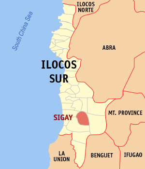
Sigay, officially the Municipality of Sigay, is a 5th class municipality in the province of Ilocos Sur, Philippines. According to the 2020 census, it has a population of 2,552 people.
Tagudin, officially the Municipality of Tagudin, is a 2nd class municipality in the province of Ilocos Sur, Philippines. According to the 2020 census, it has a population of 41,538 people.
Balaoan, officially the Municipality of Balaoan, is a 1st class municipality in the province of La Union, Philippines. According to the 2020 census, it has a population of 40,339.
Naguilian, officially the Municipality of Naguilian, is a 1st class municipality in the province of La Union, Philippines. According to the 2020 census, it has a population of 52,189 people.
San Juan, officially the Municipality of San Juan, is a 2nd class municipality in the province of La Union, Philippines. According to the 2020 census, it has a population of 40,507 people.
Sudipen , officially the Municipality of Sudipen, is a 4th class municipality in the province of La Union, Philippines. According to the 2020 census, it has a population of 17,187 people.
Sagada, officially the Municipality of Sagada is a 5th class municipality in the province of Mountain Province, Philippines. According to the 2020 census, it has a population of 11,510 people.
Mankayan, officially the Municipality of Mankayan, is a 1st class municipality in the province of Benguet, Philippines. According to the 2020 census, it has a population of 37,233 people.
Amburayan was an administrative division of the Philippines, existing as a politico-military comandancia from 1890 to 1902, and a sub-province from 1902 to 1920. Its territory encompassed most of the Amburayan River watershed, initially predominantly inhabited by the Kankana-ey.
Lepanto-Bontoc was a province of the Philippines, existing from 1902 to 1908. The province encompassed much of the central section of the Cordillera mountains in Luzon. Its capital was Cervantes, in the sub-province of Lepanto.
This page is based on this Wikipedia article Text is available under the CC BY-SA 4.0 license; additional terms may apply. Images, videos and audio are available under their respective licenses.