Chesterfield Charter Township is a charter township of Macomb County in the U.S. state of Michigan. As of the 2020 census the population was 45,376.

Macomb Township is a civil township of Macomb County in the U.S. state of Michigan. The population was 91,663 at the 2020 census, up from 79,580 in 2010. As of 2020 it was the most-populous civil township in the state and the third most-populous township overall after the charter townships of Clinton and Canton.

Highland Township, officially the Charter Township of Highland, is a charter township of west Oakland County, Michigan. The population was 19,202 at the time of the 2010 census.

In geology, hotspots are volcanic locales thought to be fed by underlying mantle that is anomalously hot compared with the surrounding mantle. Examples include the Hawaii, Iceland, and Yellowstone hotspots. A hotspot's position on the Earth's surface is independent of tectonic plate boundaries, and so hotspots may create a chain of volcanoes as the plates move above them.

A spiral is a technique employed by railways to ascend steep hills.

Chantada, is a municipality in the province of Lugo, Galicia, Spain.
Taboada is a municipality in the province of Lugo, in the autonomous community of Galicia, Spain. It belongs to the comarca of Chantada. Taboada is a natural entry to the Ribeira Sacra.

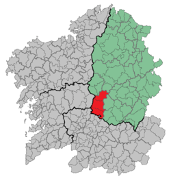
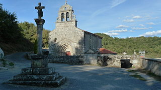
Carballedo is a municipality in the province of Lugo, in the autonomous community of Galicia, northwestern Spain. It belongs to the comarca of Chantada.

Friol is a municipality in the Lugo province in Galicia. It is located in northwest Spain. It is bordered on the north by Begonte and Guitiriz, to the south by Palas de Rei and Guntín, to the east by Lugo and Outeiro de Rei and to the west by the province of La Coruña. It has an area of 295 km2. It has a population of 4,533 inhabitants according to the INE in 2005. The population density is 15.36 inhabitants/km2.
O Saviñao is a Concello (council) in the province of Lugo, Galicia belonging to the district of Terra de Lemos. The main town for the council is Escairón.

Ribeira Sacra is a Spanish Denominación de Origen Protegida (DOP) for wines located in the south of the province of Lugo and in the north of the province of Ourense, in Galicia, Spain. It extends over the territories of 20 different municipalities that conform a zone and entity called Ribeira Sacra, which could be translated as "Sacred Shore". The vineyards are planted on the steep slopes of the valleys and canyons of the rivers Miño and Sil. The area acquired official Denominación de Origen status in 1996.

European route E1 is a series of roads in Europe, part of the United Nations International E-road network, running from Larne, Northern Ireland to Seville, Spain. There is a sea crossing between Rosslare Harbour, in Ireland, and Ferrol, but no ferry service. The road also passes through Portugal – past the city of Porto, through the capital, Lisbon, and then south to the Algarve, passing Faro before reaching the Spanish border west of Huelva.
North Bend Air Force Station is a closed United States Air Force General Surveillance Radar station. It is located 3.9 miles (6.3 km) north-northeast of Hauser, Oregon. It was closed in 1980.
The muiñeira is a traditional dance and musical genre of Galicia and some parts of Asturias (Spain). It is distinguished mainly by its expressive and lively tempo, played usually in 6
8, although some variants are performed in other time signatures. There are also variant types of muiñeira which remain in the tempo of 6
8 but which displace the accent in different ways. Muiñeira is associated with traditional choreographic schemes and the associated instrumentation is a form of bagpipe known as a gaita. It is subject to highly varied interpretation in differing local traditions. According to "Galicia-The Spanish Cousins", an article on Roots World, muiñeira is the Galician "equivalent" of a jig, which is consistent with the time signature of 6
8. The word "muiñeira" means literally both millstone and a mill landlady. Galician music is classified as part of Celtic music.

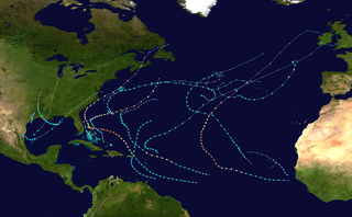
The 2018 Atlantic hurricane season was an event in the annual hurricane season in the north Atlantic Ocean. It as an above-average season for tropical cyclones for the third consecutive year. Though the season officially began on June 1, 2018 and ended November 30, 2018, dates adopted by convention and historically describe the period during each year when most tropical cyclones form, it effectively started with the formation of Tropical Storm Alberto on May 25. The season's final storm, Hurricane Oscar, dissipated on October 31.

The 2018 Pacific hurricane season was an event in the annual cycle of tropical cyclone formation, in which tropical cyclones form in the eastern Pacific Ocean. The season officially started on May 15 in the eastern Pacific—east of 140°W—and began on June 1 in the central Pacific—the region between the International Date Line and 140°W, and ended on November 30. These dates typically cover the period of each year when most tropical cyclones form in the eastern Pacific basin. The season began with the formation of Tropical Depression One-E, which developed on May 10, and ended with the dissipation of the season's final storm, Tropical Storm Xavier, which dissipated as a tropical cyclone on November 5.
The 2019 Atlantic hurricane season was an event in the annual tropical cyclone season in the north Atlantic Ocean. It was the fourth consecutive above-normal Atlantic hurricane season. The season officially began on June 1, 2019 and ended on November 30, 2019. These dates, adopted by convention, historically describe the period in each year when most tropical systems form. However, storm formation is possible at any time of the year, as demonstrated in 2019 by the formation of the season's first named storm, Subtropical Storm Andrea, on May 20. The final storm of the season, Tropical Storm Sebastien, transitioned to an extratropical cyclone on November 25.

The 2020 Atlantic hurricane season was the most active Atlantic hurricane season on record in terms of number of named storms. Additionally, it was as an above-average season for tropical cyclones for the fifth consecutive year. The season officially began on June 1, 2020, and ended on November 30, 2020. These dates, adopted by convention, historically delimit the period each year when most Atlantic tropical systems form. However, storm formation is possible at any time of the year, as was the case this season, when its first two named storms, Tropical Storm Arthur and Tropical Storm Bertha, formed on May 16 and May 27, respectively. The final storm, Hurricane Iota, dissipated on November 18.