Lugo | |
|---|---|
 | |
| Country | |
| Autonomous community | |
| Province | Lugo |
| Capital | Lugo |
| Municipalities | List |
| Time zone | UTC+1 (CET) |
| • Summer (DST) | UTC+2 (CEST) |
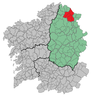
Lugo is a comarca in the Galician province of Lugo. It had a population of 118,931 as of 2019. [1]
Lugo | |
|---|---|
| | |
| Country | |
| Autonomous community | |
| Province | Lugo |
| Capital | Lugo |
| Municipalities | List |
| Time zone | UTC+1 (CET) |
| • Summer (DST) | UTC+2 (CEST) |
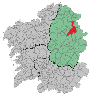
Lugo is a comarca in the Galician province of Lugo. It had a population of 118,931 as of 2019. [1]
Castroverde, O Corgo, Friol, Guntín, Lugo , Outeiro de Rei, Portomarín and Rábade.

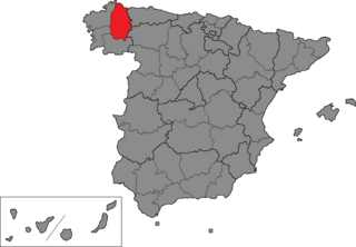
Lugo is a province of northwestern Spain, in the northeastern part of the autonomous community of Galicia. It is bordered by the provinces of Ourense, Pontevedra, and A Coruña, the principality of Asturias, the State of León, and in the north by the Cantabrian Sea.

Xove is a municipality of Galicia, Spain in the province of Lugo.

Castro de Rei, is a municipality in the province of Lugo, in the autonomous community of Galicia, Spain. It belongs to the comarca of Terra Chá. The population in 2009 was 5,685 people according to INE.

Friol is a municipality in the Lugo province in Galicia. It is located in northwest Spain. It is bordered on the north by Begonte and Guitiriz, to the south by Palas de Rei and Guntín, to the east by Lugo and Outeiro de Rei and to the west by the province of La Coruña. It has an area of 295 km2. It has a population of 4,533 inhabitants according to the INE in 2005. The population density is 15.36 inhabitants/km2.

Lourenzá is a municipality in the province of Lugo, in the autonomous community of Galicia in northwestern Spain.

A Fonsagrada is a comarca in the Galician Province of Lugo. The overall population of this local region is 4,921 (2019).
A Mariña Central is a comarca in the Galician Province of Lugo. The overall population of this local region is 28,955 (2019). This region is a political-administrative division of A Mariña de Lugo macro-region. To the north and northeast the region borders the Bay of Biscay, on the northwest with La Mariña, to the west and south by the Terra Chá, Meira on the southeast and east with A Mariña Oriental.

A Mariña Occidental is a comarca in the Galician Province of Lugo. The overall population of this local region is 25,659 (2019).

A Mariña Oriental is a comarca in the Galician Province of Lugo. The overall population of this local region is 28,955 (2019).
Meira is a local region in the Galician Province of Lugo. The overall population of this local region is 5,124 (2019).

Ortegal is a comarca in the north of the Galician Province of A Coruña, Spain. It borders the Atlantic Ocean and the Cantabrian Sea to the north, the Province of Lugo to the east, the comarca of O Eume to the south, and comarca of Ferrol to the west. It covers an area of 394.3 sq.km, which accounts for 1.33% of all the land area in Galicia. The overall population of this region was 13,916 at the 2011 census; the latest official 2022 census was 11,466.

Riotorto is a town located in the Spanish province of Lugo.

The French submarine Rubis was a Saphir-class minelaying submarine which first served in the French submarine force, then the Free French Naval Forces (FNFL) during the Second World War and back with the French Navy. The boat was awarded numerous awards. Accordingly, as a result of Rubis's service with the FNFL, the boat was made a companion of the Ordre de la Libération by a decree issued by General Charles de Gaulle on 14 October 1941.

Bekily is a town in the region of Androy and in the former Toliara Province, Madagascar. It is situated at the Menarandra River in the South of Madagascar.
The Lyackson First Nation is a First Nations band government located at Chemainus, British Columbia, Canada, on Vancouver Island.

The Estadio Anxo Carro, also known as Estadio Ángel Carro, is a stadium located in Lugo, Galicia, Spain. It is currently used for football matches and is the home stadium of CD Lugo.
Polvorín Fútbol Club, previously Sociedad Deportiva e Cultural Polvorín, is a Spanish football team based in Lugo, in the autonomous community of Galicia. Founded in 1991, it plays in Tercera Federación – Group 1, holding home matches at Campo Municipal de A Cheda with a capacity of 1,000 seats.

The Roman bridge of Lugo crosses the Minho river in Lugo, Galicia. The bridge is of Roman origin and has been rebuilt many times in its history.
Lugo is one of the 59 constituencies represented in the Senate of Spain, the upper chamber of the Spanish parliament, the Cortes Generales. The constituency elects four senators. Its boundaries correspond to those of the Spanish province of Lugo. The electoral system uses an open list partial block voting, with electors voting for individual candidates instead of parties. Electors can vote for up to three candidates.