Charles Robertson Grant Deed

Last updated

The Charles Robertson Grant, also known more simply as the Watauga Grant, was a transaction for the sale of land by the Cherokee Nation to Charles Robertson. The transaction occurred at Sycamore Shoals on the Watauga River on March 19, 1775. The Charles Robertson Grant was for a large tract in what is now East Tennessee and Western North Carolina, some of which had been previously leased from the Cherokee.

Contents

A map showing the boundaries of the 1775 Watauga or Charles Robertson Grant overlaid with present-day state borders and populated areas. 1775 Watauga Grant.png
A map showing the boundaries of the 1775 Watauga or Charles Robertson Grant overlaid with present-day state borders and populated areas.

Location

The Charles Robertson Grant was one of five property transactions made at Sycamore Shoals in the present day city of Elizabethton, Tennessee. Collectively known as the Watauga Treaties the transactions resulted in the Great Grant Deed, the Path Grant Deed, two Jacob Brown Grant Deeds and the Charles Robertson Grant Deeds. The Great Grant provided for the sale of land in Central Kentucky to the Richard Henderson and Company and was transacted on March 17, 1775. [1] [2] The Path Grant provided for the sale of land in present day East Tennessee and Southwest Virginia and provided a secure path way into the Great Grant land in Kentucky. The Jacob Brown Grants provided for the sale of property included within the Nolichucky River watershed in present day Greene County Tennessee. The Robertson and Brown Grants clarified ownership of existing settlers south of the Treaty of Lochaber line and the Holston River

The Charles Robertson Deed resulted from what were early agreements with the Cherokee and other Native Americans for land west of the Allegheny Mountains. The Watauga Treaties were the beginning of the American Westward Expansion.

The Watauga Settler Buyers

As Clerk who was appointed Trustee for the Watauga Association, Charles Robertson bought the property from the Cherokee for the sum of 2,000 British Pounds. [3] Previously, the association had leased the property including the settlements from the Cherokee. The Charles Robertson purchase from the Cherokee was mirrored a few days later by Jacob Brown for the adjacent Nolichucky Grants.

The Tennessee Historical Marker located at Sycamore Shoals in Elizabethton Tennessee describing the Watauga Association land purchase from the Cherokee by Charles Robertson in March 1775 Watauga Association Marker.jpg
The Tennessee Historical Marker located at Sycamore Shoals in Elizabethton Tennessee describing the Watauga Association land purchase from the Cherokee by Charles Robertson in March 1775

As Trustee, Charles Robertson recorded the grant in the original ledger book. Subsequently, this ledger was used by James Smith who became clerk of the land office that opened in Ft Watauga on April 1, 1775. The ledger is known as "Old Book A". The Charles Robertson Deed is on Page 1. Later with the formal establishment of Washington County by North Carolina, the book was transferred to Jonesborough. The original book is said to reside in the original land office papers held by the North Carolina State Archives. A copy is in the custody of the Tennessee State Library and Archives. [4] The property included was deeded to the present holders, lessors, who were now provided clear unequivocal title to the land.

On March 19, 1775, the day of the Charles Robertson Watauga purchase, 175 of the Watauga settlers petitioned the North Carolina Legislature to become a county. The petition indicated a need for government and court jurisdiction. [5] The request went unheeded and another petition was sent more than a year later. This time, the petition was quite lengthy and to add emphasis, there were many more signers.

In August 1776, the Watauga settlers again petitioned North Carolina for formal recognition. There is no date on the petition but it was marked Received August 22, 1776. To emphasize desire and need, this petition is quite long and contains the signatures of 466 male Watauga settlers. [6]

The petition notes the uncertainty and confusion of the Watauga settlers that resulted from the current law and the colonial government under which they might be governed. There was confusion [7] as to where the line separating Virginia from North Carolina actually existed on the ground where they were living. The Donaldson Survey of 1772 established the line as latitude 36° 30' and a very precise point that was where the South Fork of the Holston river intersected with line at a point 6 miles upstream from the tip of the Long Island of the Holston. [8] [9] [10]

Many historians treat the petition with short summations. The petition provides keen insight into the angst and thinking of the Watauga settlers. The petition provides an understanding of the place and time and should be read in its entirety. File:Petition to North Carolina By the Washington District.pdf  via Wikisource.The fact there are 466 signers on this second petition is not insignificant. The petitioners were very serious in their purpose.

The Cherokee Sellers

In 1775, there were 64 Cherokee towns with a total population of less than 9,000 people known collectively as the Overhill, Middle Town and Lower Towns [11] By the 1750s the Cherokee population stood at approximately 25,000. Twenty years later through open warfare with the relentlessly encroaching white population and by the ravaging effect of diseases carried by explorers and settlers the population had been reduced to less than 9,000. [12]

The map "Cherokee-Creek Country 1760-1781" by Coulter-Swanton Indicates Holston River settlements and Ft Patrick Henry but no Cherokee habitations. In the Journal of Dr Thomas Walker entry for March 31, 1749 – 1750, [13] he indicates discovery of abandoned Cherokee houses at the convergence of the north and south forks of the Holston River. He also noted a large abandoned fort downstream about four miles.

The Cherokee had abandoned the lands along the Holston, Watauga and Nolichucky rivers. Thus Oconistoto, Attacullicully & Savanuka were in effect selling property surplus to their needs. Having previously negotiated with the same settlers for the lease of the same property, it can be surmised that the Cherokee either did not recognize the difference between a lease and quitclaim sale, or more likely, the Cherokee elders were pleased to accept the second payment of 2,000 British pounds.

The Watauga Grant Deed

The geographical extent of the Watauga Grant corresponds to the northeasternmost portion of present-day Tennessee and the northwesternmost portion of present-day North Carolina. The boundaries were described in Old Book A, Page 1, shown below in bold, as comprising the Watauga River watershed in present-day Tennessee and North Carolina, the portion of the New River watershed that falls within present-day North Carolina, and the area in present-day Tennessee south of the South Fork of the Holston River and east of present-day Kingsport, TN.

Old Book A
Deed Book Page 1
This Indenture made this nineteenth day of March in the year of our Lord Christ one thousand seven hundred and seventy five Between Oconistoto Chief Warrior and first representative of the Cherokee Nation or tribe of Indians & Attacullaculy & Savanucah otherwise Coronoh for themselves and the rest of the whole nation being Aborigines and sole owners by occupation from the beginning of time of the Lands on the waters of Holston & Wataugah rivers & other Lands & Territories thereunto belonging of the one part and Charles Robertson of the Settlement of Wataugah of the other part Witnesseth, that the said Oconistoto for himself and the rest of the said Nation of Indians for and in consideration of two thousand pounds of Lawful money of Great Brittain to them in hand paid by the said Charles Roberson the receipt whereof the said Oconostoto and the whole nation do and for themselves and their whole tribe of people have granted bargained and sold aliened enfeoff'd releas'd and confirmed and by these presents do grant bargain sell enfeoff release and confirm unto him the said Charles Robertson his heirs and assigns forever all that tract territory or parcel of Land on the waters of Wataugah, Holston and great Conaway or New River Beginning on the south or south west side of Holston River six English Miles above the Long Island in said river thence a direct line over a So. Wt. course to the ridge which divides the waters of Wataugah from the waters of Nonachuckeh thence along the various courses of said ridge nearly a south east course to the blue ridge or line dividing North Carolina from the Cherokee Lands. Thence along the various courses of said ridge to the Virginia line thence West along the Virginia line to Holston river

Deed Book Page 2
The Deed obtained from the thence down the meanders of Holston river to the first station including all the waters of Wataugah part of the waters of Holston and the head branches of New river or great Canaway agreeable to the bounds aforesaid, and also the reversion & reversions remainder & remainders, rents and issues thereof and all the Estate right title Interest claim and demand whatsoever of them the said Oconistoto and the aforesaid whole band or tribe of people in and to the same premises & of in and to the every part and parcel thereof. To have and to hold the said message and territory and all the singular the premises above mentioned with the appurtenances unto the said Charles Roberson his heirs and assigns in severalty and tenants in common and not as Joint to the only proper use and behoof of the said Charles Robertson his heirs and assigns forever under the yearly rent of four pence or to beholden of the Chief Lords or Lords of the Fee of the premises by the rents and services therefore due and of right accustomed, and the said Oconistoto and the said Nation for themselves do covenant and grant to and with the said Charles Robertson his heirs and assigns that they the said Oconistoto and the rest of the said Nation of people now are lawfully and rightfully seized in their own right of a good sure perfect and absolute and indefeasible estate of Inheritance in fee simple of and in all and singular the said Messuage territory and premises above mentioned and of all & every part and parcel thereof with the appurtenances with out any manner of condition mortgage limitation of use or uses or other matter cause or thing to alter change charge or

Deed Book Page 3
Cherokees for the Wataugah Purchase determine the same and also that the Oconistoto and the aforesaid Nation now have good full power and lawful Authority in their own right to grand bargain & sell and convey the said messuage territory and premises above mentioned with the appurtenances unto the said Charles Robertson his heirs and assigns according to the true intent and meaning of these presents and also the said Charles Robertson his heirs and assigns shall and may from time to time and at all times hereafter peaceably and quietly have hold possess and enjoy all and singular the said premises above mentioned to be hereby granted with the appurtenances, without the trouble hindrance molestation interruption and denial of them the said Oconistoto and the rest or any of the said nation their heirs or assigns and of all and every other person and persons whatsoever claiming or to claim by power or under them or any of them; and lastly the said Oconistoto Atticullicully Savenuka otherwise Coronoh for themselves and in behalf of the whole nation and their heirs and all and every other person and persons and his and their heirs anything having or claiming in the said Messuage territory and persons above mentioned or any part thereof by power or under them shall and will at all times hereafter, at the request and costs of the said Charles Roberson his heirs or assigns make do and execute or cause or procure to be made done or executed all and every further and other lawful and reasonable grants, acts and appurtenances in the law whatsoever for the further better and the more perfect granting conveying and assuring of the

Deed Book Page 4
Deed Obtained from the Indians said premises hereby granted with the appurtenances unto the said Charles Robertson his heirs and assigns to the only proper use and behoof of the said Charles Roberson his heirs and assigns forever according to the true intent and meaning of these presents ratifying and confirming and allowing all and whatsoever he shall do in the premises. In Witness whereof the said Oconistoto Attacullicully & Savanuka other wise Coronoh for themselves and in behalf of the whole Nation hath here unto set their hands and affixed their seals the day and year first written.

Signed Sealed & delivered In presence of

John Sevier Oconistoto & his mark (seal)
William Bailey Smith Atticullicully C his mark (seal)
Jesse Benton Tennessy Warrior X his mark (seal)
Tilmon DixonWillinawaugh # his mark (seal)
William Blevins
Thomas Price

Jos. Vann, (seal) Linquester [14]

The Watauga settlers William Baily Smith, Tilman Dixon, and Thomas Price and the Cherokee Attaculla and Savanooko, and the Translator Joseph Vann also signed the Path Grant Deed.

Actions by North Carolina

The Great Grant Deed article indicates that the entire proceedings at Sycamore Shoals were likely transactions by sellers with no right to sell and buyers with no right to buy. In the Charles Roberson transactions that statement turned out to be only half true. The Cherokee were certainly the aboriginal owners of the property along the Watauga. [15] The Royal Proclamation of 1763 by King George III prohibited settlement of the lands west of the Alleghenies which formed the Eastern Continental Divide. [16] [17] Such lands were considered to be Indian Lands but not subject to sale to British Crown colonists.

A controversy that grew out of the Great Grant directly affected the people of the Watauga settlements. In anticipation of the various land transactions eventually made at Sycamore Shoals in March 1775, North Carolina Governor Martin issued a proclamation in February 1775 in opposition. [18] Subsequently in accord with Virginia and the voices of the Watauga settlers demanding clarification of the boundaries, North Carolina nullified the Transylvania Colony and asserted sovereignty over the western territory. That western territory was declared to be the Washington District and included all of what is now Tennessee. This action formally transpired in November 1777. [19] [20] Along with the Great Grant and the Henderson Memorial to the commission requesting relief, the Watauga Treaty Grants of 1775 were ignored by the Virginia and North Carolina commissioners who were negotiating with the Cherokee at the Treaty of Long Island in July 1777. [21]

Thus in a negative turn of events, the Charles Robertson purchase was found to be null and void.

As was noted in the Jacob Brown Grant Deeds article, the object of North Carolina when negotiating the Treaty of Long Island 1777 in nullifying the Charles Robertson Grant Deed was not to penalize the settlers. The object was to reach agreement with the Cherokee and to place the lands under recognized governmental control. Subsequently, in 1778, land offices were opened, and procedures established for the settlers to obtain permanent North Carolina sanctioned ownership and titled. [22] To make the settler's land claim official, a warrant for a survey was issued by North Carolina, a survey was made and submitted with a grant application. On payment of 50 shillings per one hundred acres a grant for the land was issued. The deed was recorded in the Washington District office in what is known as Old Deed Book A. On formal establishment of Washington County, Old Deed Book A was abandoned with a new set of deed books still in existence. [23] [24]

Related Research Articles

<span class="mw-page-title-main">Elizabethton, Tennessee</span> City in Tennessee, United States

Elizabethton is a city in, and the county seat of Carter County, Tennessee, United States. Elizabethton is the historical site of the first independent American government located west of both the Eastern Continental Divide and the original Thirteen Colonies.

<span class="mw-page-title-main">Transylvania Colony</span> Short-lived extra-legal colony in frontier Kentucky

The Transylvania Colony, also referred to as the Transylvania Purchase, was a short-lived, extra-legal colony founded in early 1775 by North Carolina land speculator Richard Henderson, who formed and controlled the Transylvania Company. Henderson and his investors had reached an agreement to purchase a vast tract of Cherokee lands west of the southern and central Appalachian Mountains through the acceptance of the Treaty of Sycamore Shoals with most leading Cherokee chieftains then controlling these lands. In exchange for the land the tribes received goods worth, according to the estimates of some scholars, about 10,000 British pounds. To further complicate matters, this frontier land was also claimed by the Virginia Colony and a southern portion by Province of North Carolina.

<span class="mw-page-title-main">Southwest Territory</span> Territory of the USA from 1790 to 1796

The Territory South of the River Ohio, more commonly known as the Southwest Territory, was an organized incorporated territory of the United States that existed from May 26, 1790, until June 1, 1796, when it was admitted to the United States as the State of Tennessee. The Southwest Territory was created by the Southwest Ordinance from lands of the Washington District that had been ceded to the U.S. federal government by North Carolina. The territory's lone governor was William Blount.

<span class="mw-page-title-main">John Sevier</span> Soldier, frontiersman and politician

John Sevier was an American soldier, frontiersman, and politician, and one of the founding fathers of the State of Tennessee. A member of the Democratic-Republican Party, he played a leading role in Tennessee's pre-statehood period, both militarily and politically, and he was elected the state's first governor in 1796. He served as a colonel of the Washington District Regiment in the Battle of Kings Mountain in 1780, and he commanded the frontier militia in dozens of battles against the Cherokee in the 1780s and 1790s.

<span class="mw-page-title-main">Holston River</span> River in Tennessee, United States

The Holston River is a 136-mile (219 km) river that flows from Kingsport, Tennessee, to Knoxville, Tennessee. Along with its three major forks, it comprises a major river system that drains much of northeastern Tennessee, southwestern Virginia, and northwestern North Carolina. The Holston's confluence with the French Broad River at Knoxville marks the beginning of the Tennessee River.

<span class="mw-page-title-main">James Robertson (explorer)</span> Explorer and pioneer, born 1742

James Robertson was an American explorer, soldier and Indian agent, and one of the founding fathers of what became the State of Tennessee. An early companion of explorer Daniel Boone, Robertson helped establish the Watauga Association in the early 1770s, and to defend Fort Watauga from an attack by Cherokee in 1776. In 1779, he co-founded what is now Nashville, and was instrumental in the settlement of Middle Tennessee. He served as a brigadier general in the Southwest Territory militia in the early 1790s, and as an Indian Commissioner in later life.

<span class="mw-page-title-main">Overmountain Men</span> American frontiersmen from west of the Appalachian Mountains

The Overmountain Men were American frontiersmen from west of the Blue Ridge Mountains which are the leading edge of the Appalachian Mountains, who took part in the American Revolutionary War. While they were present at multiple engagements in the war's southern campaign, they are best known for their role in the American victory at the Battle of Kings Mountain in 1780. The term "overmountain" arose because their settlements were west of, or "over", the Blue Ridge, which was the primary geographical boundary dividing several of the 13 American states from the Native American lands to the west. The Overmountain Men hailed from parts of Virginia, North Carolina, and what is now Tennessee and Kentucky.

<span class="mw-page-title-main">Watauga Association</span> 18th Century semi-autonomous government

The Watauga Association was a semi-autonomous government created in 1772 by frontier settlers living along the Watauga River in what is now Elizabethton, Tennessee. Although it lasted only a few years, the Watauga Association provided a basis for what later developed into the state of Tennessee and likely influenced other western frontier governments in the trans-Appalachian region. North Carolina annexed the Watauga settlement area, by then known as the Washington District, in November 1776. Within a year, the area was placed under a county government, becoming Washington County, North Carolina, in November 1777. This area covers the present day Washington County, Carter County, and other areas now located in the northeast part of the state of Tennessee.

<span class="mw-page-title-main">Fort Nashborough</span> United States historic place

Fort Nashborough, also known as Fort Bluff, Bluff Station, French Lick Fort, Cumberland River Fort and other names, was the stockade established in early 1779 in the French Lick area of the Cumberland River valley, as a forerunner to the settlement that would become the city of Nashville, Tennessee. The fort was not a military garrison. The log stockade was square in shape and covered 2 acres (8,100 m2). It contained 20 log cabins and was protection for the settlers against wild animals and Indians. James Robertson and John Donelson are considered the founders, and colloquially, the "founders of Tennessee". The fort was abandoned in 1794, but the settlement, now the town of Nashville, became the capital of the new state of Tennessee in 1796.

<span class="mw-page-title-main">Richard Henderson (jurist)</span> American pioneer

Richard Henderson was an American jurist, land speculator and politician who was best known for attempting to create the Transylvania Colony in frontier Kentucky. Henderson County and its seat Henderson, Kentucky are named for him. He also sold land to an early settlement that went on to become Nashville, Tennessee.

<span class="mw-page-title-main">Sycamore Shoals</span> River rapids along the Watauga River in Elizabethton, Tennessee, US

The Sycamore Shoals of the Watauga River, usually shortened to Sycamore Shoals, is a rocky stretch of river rapids along the Watauga River in Elizabethton, Tennessee. Archeological excavations have found Native Americans lived near the shoals since prehistoric times, and Cherokees gathered there. As Europeans began settling the Trans-Appalachian frontier, the shoals proved strategic militarily, as well as shaped the economies of Tennessee and Kentucky. Today, the shoals are protected as a National Historic Landmark and are maintained as part of Sycamore Shoals State Historic Park.

<span class="mw-page-title-main">Cherokee–American wars</span> Indian wars in the Old Southwest

The Cherokee–American wars, also known as the Chickamauga Wars, were a series of raids, campaigns, ambushes, minor skirmishes, and several full-scale frontier battles in the Old Southwest from 1776 to 1794 between the Cherokee and American settlers on the frontier. Most of the events took place in the Upper South region. While the fighting stretched across the entire period, there were extended periods with little or no action.

The Treaty of Lochaber was signed in South Carolina on 18 October 1770 by British representative John Stuart and the Cherokee people, fixing the boundary for the western limit of the colonial frontier settlements of Virginia and North Carolina.

<span class="mw-page-title-main">Fort Watauga</span>

Fort Watauga, also known as Fort Caswell, was a fortification located in the Watauga River's Sycamore Shoals near modern-day Elizabethton, Tennessee. It was constructed from 1775 to 1776 by the Watauga Association, a semi-autonomous government founded by American settlers living near the river, to defend the settlers against attacks from British-allied Indians. The fort was originally named Fort Caswell after the governor of North Carolina, Richard Caswell.

<span class="mw-page-title-main">Sycamore Shoals State Historic Area</span> State park in Elizabethton, Tennessee, USA

Sycamore Shoals State Historic Area is a state park located in Elizabethton, in the U.S. state of Tennessee. The park consists of 70 acres (28.3 ha) situated along the Sycamore Shoals of the Watauga River, a National Historic Landmark where a series of events critical to the establishment of the states of Tennessee and Kentucky, and the settlement of the Trans-Appalachian frontier in general, took place. Along with the historic shoals, the park includes a visitor center and museum, the reconstructed Fort Watauga, the Carter House and Sabine Hill . For over a thousand years before the arrival of European explorers, Sycamore Shoals and adjacent lands had been inhabited by Native Americans. The first permanent European settlers arrived in 1770, and established the Watauga Association—one of the first written constitutional governments west of the Appalachian Mountains—in 1772. Richard Henderson and Daniel Boone negotiated the Treaty of Sycamore Shoals in 1775, which saw the sale of millions of acres of Cherokee lands in Kentucky and Tennessee and led to the building of the Wilderness Road. During the American Revolution, Sycamore Shoals was both the site of Fort Watauga, where part of a Cherokee invasion was thwarted in 1776, and the mustering ground for the Overmountain Men in 1780.

The Washington District of North Carolina was in a remote area west of the Appalachian Mountains, officially existing for only a short period, although it had been self-proclaimed and functioning as an independent governing entity since the spring of 1775. The district was the bureaucratic successor to the Watauga Association, a group of Virginian settlers that colonized the area in 1769, originally believing themselves to be in trans-Appalachian Virginia territory. When the settlement's application to be united with Virginia was denied, they asked North Carolina to annex the settlement, which occurred in November, 1776.

<span class="mw-page-title-main">William Bean</span> Tennessees first permanent European-American settler

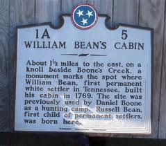
William Bean was an American pioneer, longhunter, and Commissioner of the Watauga Association. He is accepted by historians as the first permanent European American settler of Tennessee.

<span class="mw-page-title-main">Path Grant Deed</span>

The Path Grant Deed is a document regarded as a first step toward the American westward migration across the Appalachian Mountains, resulting from negotiations at Sycamore Shoals in March 1775. The land acquired within the boundaries of the Path Grant allowed Daniel Boone to develop the Wilderness Road free from attack or claims by the Cherokee. The Path Grant was recorded on November 15, 1794, by the Hawkins County, Tennessee registrar in Deed Book #1, pages 147-151

<span class="mw-page-title-main">Great Grant Deed</span> Transaction for the sale of property by the Cherokee Nation

The Great Grant Deed, also known as The Great Grant, was a transaction for the sale of property by the Cherokee Nation to Richard Henderson and Company. The grant is also known as the Louisa purchase or the Transylvania purchase. The transaction occurred at Sycamore Shoals on the Watauga River on March 17, 1775. The Great Grant was for lands forming Henderson's new Transylvania Colony comprising much of what is now the state of Kentucky.

The Jacob Brown Grant Deeds, also known more simply as the Nolichucky Grants, were transactions for the sale of land by the Cherokee Nation to Jacob Brown. The transaction occurred at Sycamore Shoals on the Watauga River on March 25, 1775. The Jacob Brown grants were for two large tracts along the Nolichucky River some of which had been previously leased from the Cherokee.

References

  1. Skinner page 170
  2. Ramsey Page 119
  3. Ramsey page 119
  4. Tennessee State Library and Archives
  5. Keesee,page 92
  6. Ramsey, page 138
  7. Hamer page 67
  8. Folmsbee, page 754,755
  9. Treaty of Lochaber
  10. File:Petition to North Carolina By the Washington District.pdf  via Wikisource.
  11. Ramsey page 82
  12. Native American Footprints on the Land
  13. Walker Diary, March 31, 1749-1750
  14. Charles Robertson Deed, Tennessee State Archives and Library
  15. Ramsey page 119
  16. Skinner page 111
  17. Ramsey page 71
  18. Henderson 1 page 277
  19. Henderson 1,Page 277
  20. Henderson 2, page 57
  21. Henderson 2, page
  22. Pruitt
  23. Keese
  24. Pruitt

Sources