
Spring Hill is the name of a ridge in the central part of the city of Somerville, Massachusetts, and the residential neighborhood that sits atop it. It runs northwest to southeast, roughly bounded by Highland Avenue, Somerville Avenue, Elm Street, and Willow Avenue. Summer Street runs along the hill's crest.
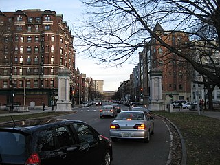
The Fenway-Boylston Street District is a historic district encompassing a series of predominantly residential buildings lining The Fenway in the Fenway–Kenmore of Boston, Massachusetts. Developed beginning in the 1890s, the area is emblematic of Boston's upper-class residential development of the period, with architect-designed houses built for some of the city's leading families. The district was listed on the National Register of Historic Places in 1984.

The Lower Roxbury Historic District is a historic district encompassing an isolated pocket of 1890s mixed residential-commercial property in the lower Roxbury neighborhood of Boston, Massachusetts. Bounded by Tremont, Columbus, and Burke Streets and St. Cyprian's Place, the area contains a well-kept collection of architect designed buildings that survived late 20th-century urban redevelopment. The district was added to the National Register of Historic Places in 1994.

Morton Street is a street in southern Boston, Massachusetts. It extends from the southeastern end of the Arborway in Jamaica Plain to Washington Street in the Lower Mills Village of Dorchester. Most of the road is a connecting parkway, signed as part of Massachusetts Route 203, that provides access to Boston's Emerald Necklace of parks. That portion of the road was listed on the National Register of Historic Places in 2005.

Mount Pleasant Historic District is a historic district encompassing a cluster of well-preserved 19th-century residential buildings on Forest Street and Mount Pleasant Avenue in the Roxbury neighborhood of Boston, Massachusetts. First developed in 1833, it was one Roxbury's first speculative residential subdivision developments. The district features Greek Revival, Italianate, and Romanesque architecture, and was added to the National Register of Historic Places in 1989.

The Sumner Hill Historic District encompasses a predominantly residential area of high-quality late 19th-century residences in the Jamaica Plain neighborhood of Boston, Massachusetts. It is roughly bounded by Seaverns Avenue, Everett Street, Carolina Avenue, and Newbern Street just east of the neighborhoods commercial Centre Street area. The district features Second Empire, Italianate, and Queen Anne style architecture, and was listed on the National Register of Historic Places in 1987.

The Avon Hill Historic District is a residential historic district near Porter Square in Cambridge, Massachusetts. Set atop Avon Hill southwest of Porter Square, this subdivision, laid out about 1870, contains a concentration of the finest Victorian and Second Empire residential buildings in the city. The district was listed on the National Register of Historic Places in 1983.
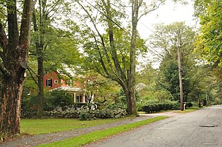
The Silver Hill Historic District encompasses the first major residential subdivision of Weston, Massachusetts. It includes 79 buildings on Silver Hill and Westland Roads, and Merriam Street. The area of Silver Hill and Westland Roads was formally laid out in 1905, while Merriam Street is a very old country road which had seen some development in the 1890s. The houses in the district are predominantly Colonial Revival and Queen Anne in their styling, a relative rarity in Weston although common in other Boston suburbs. The district was added to the National Register of Historic Places in 2004.
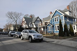
The Spring Hill Historic District is a historic district roughly bounded by Summer, Central, Atherton, and Spring Streets in the Spring Hill area of Somerville, Massachusetts. The district encompasses the city's best-preserved residential subdivision from the mid-19th century, with later infill construction in the late 19th and early 20th centuries. The district was listed on the National Register of Historic Places in 1989.

Highland Heights–Stevens' Subdivision Historic District is a residential historic district located in Highland Park, Michigan along five east-west streets: Farrand Park, McLean Street, Colorado Street, Rhode Island Street, and Massachusetts Street, between Woodward Avenue on the west and Oakland Avenue on the east. The district was listed on the National Register of Historic Places in 1988.

The Monadnock Road Historic District is a residential historic district encompassing a cohesive subdivision of a former estate in the 1920s in the Chestnut Hill section of Newton, Massachusetts. The development was typical of Newton's explosive residential growth at that time, and includes primarily Tudor Revival houses. The district was listed on the National Register of Historic Places in 1990.

Fort Hill is a 0.4 square mile neighborhood and historic district of Roxbury, in Boston, Massachusetts. The approximate boundaries of Fort Hill are Malcolm X Boulevard on the north, Washington Street on the southeast, and Columbus Avenue on the southwest.
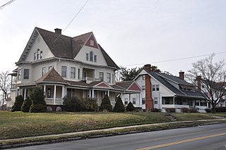
The Fairfield Avenue Historic District encompasses most of a portion of Fairfield Avenue in southern Hartford, Connecticut. Extending from Trinity College in the north to Cedar Hill Cemetery in the south, the streetscape typifies the city's development between about 1890 and 1930, a period of growth along the road fueled by the rise of streetcars. The district was listed on the National Register of Historic Places in 1984.
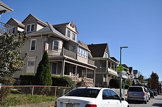
The Esmond Street Historic District is a historic district encompassing a small residential area in the Dorchester neighborhood of Boston, Massachusetts. Centered on a stretch of Esmond Street, the area was developed between 1884 and 1928, and includes a fine sample of Colonial Revival and Queen Anne architecture. The district was listed on the National Register of Historic Places in 2018.

The Intervale Street-Columbia Road Historic District is a historic district encompassing a small residential area in the Dorchester neighborhood of Boston, Massachusetts. Centered on a stretch of Intervale Street, the area was developed in the early 20th century during a major Jewish migration, and includes a fine sample of Colonial Revival architecture. The district was listed on the National Register of Historic Places in 2019.

The Intervale Street-Blue Hill Avenue Historic District is a historic district encompassing a densely built residential area in the Dorchester neighborhood of Boston, Massachusetts. Centered on a stretch of Intervale Street near Blue Hill Avenue, the area was developed in the late 19th and early 20th centuries during a major Jewish migration, and includes a fine sample of Colonial Revival architecture. The district was listed on the National Register of Historic Places in 2020.
The Crawford Street Historic District encompasses a collection of primarily residential apartment houses on Crawford Street between Elm Hill Avenue and Warren Street in the Roxbury neighborhood of Boston, Massachusetts. The area was developed in the late 19th and early 20th centuries, and features well-preserved wood frame single and multi-family residences from that period, as well as the city's only extant Brutalist style branch library building. The district was listed on the National Register of Historic Places in 2020.

The Lawrence Avenue Historic District is a historic district encompassing a small residential area in the Dorchester neighborhood of Boston, Massachusetts. Centered on Lawrence Avenue, the area was developed in the late 19th and early 20th century during a major Jewish migration, and includes a fine sample of Colonial Revival and Queen Anne architecture. The district was listed on the National Register of Historic Places in 2021.
The Humboldt Avenue Historic District is a historic district encompassing a cluster of multifamily brick buildings in the Dorchester neighborhood of Boston, Massachusetts. Centered on the junction of Humboldt Avenue and Hutchings Street, the area was developed in 1915-16 during a major Jewish migration, and includes a fine sample of Colonial Revival architecture. The district was listed on the National Register of Historic Places in 2021.
The Dudley Terrace–Dudley Street Historic District is a historic district encompassing a cluster of four multifamily brick buildings in the Dorchester neighborhood of Boston, Massachusetts. Centered on the junction of Dudley Street and Virginia Avenue, the area was developed in the mid-1890s, and includes good examples of Queen Anne and Renaissance Revival architecture. The district was listed on the National Register of Historic Places in 2022.


