
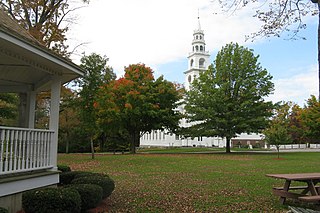
The Sturbridge Common Historic District encompasses the historic center of Sturbridge, Massachusetts. Encompassing some 138 acres (56 ha), the district is focused around the town common, which was laid out when the town established in 1738. The district is roughly linear, extending along Main Street from its junction with Interstate 84 eastward to Hall Road. The district also extends for short distances along Haynes, Maple, and Charlton Streets. Although most of the properties in the district are residential, the institutional properties, including the 1838 Greek Revival Town Hall, the 1896 Joshua Hyde Library building, and the 1922 Federated Church. The oldest building in the district is the c. 1772 Publick House, a tavern which has dominated the south side of the district since its construction.

The Brookfield Common Historic District encompasses a historically significant portion of the town center of Brookfield, Massachusetts. It is focused on the town common, which extends south from Main Street to Lincoln Street, and includes a dense cluster of houses on roads to its east, as well as properties on Main Street and the Post Road. The district includes more than 100 properties, including the Colonial Revival Town Hall, Banister Memorial Hall, and Romanesque Revival Congregation Church. The district was added to the National Register of Historic Places in 1990.

The Northside Village Historic District encompasses a rural village center on Stafford Road in northern Charlton, Massachusetts. Located at the junction of Stafford Road with Northside and Cemetery Roads is a small cluster of residential buildings, developed beginning in 1735 around a small tanning business, and later as a stagecoach stop. The district was listed on the National Register of Historic Places in 1977.

The Gardner Uptown Historic District is a historic district encompassing the former civic heart of Gardner, Massachusetts. The 65-acre (26 ha) area includes the old town common, an early cemetery, and a modest number of non-residential buildings among a larger number of houses. The area was the center of civic life from the incorporation of Gardner in 1785 until municipal functions were moved to West Gardner beginning in the late 1920s. The district was listed on the National Register of Historic Places in 1999.

The Harvard Center Historic District is a historic district encompassing the traditional village center of Harvard, Massachusetts, USA. The district is centered on the town common, a triangular grassy space bounded by Elm Street, Still River Road, and Ayer Road. The common is ringed by residences, civic and religious buildings, and a small commercial area. The common was laid out when the town was founded in 1732, and has grown, mainly in periods of growth at the late 18th and late 19th/early 20th centuries. Most of the village's buildings post-date 1831. The district was added to the National Register of Historic Places in 1997.

The West Brookfield Center Historic District is a historic district encompassing the historic center of West Brookfield, Massachusetts. When first listed on the National Register of Historic Places in 1990, it was centered on the triangular junction of Main Street, North Main Street, and School Street, extending away from this area along Main Street, North Main Street, and Foster Hill Road. A few of its properties lie on side streets adjacent to these roads. This area represented the core of Brookfield, before it was broken into smaller communities, including West Brookfield. It has a fine collection of 18th and 19th century homes, ranging stylistically from Federal to Queen Anne, as well as the town hall and public library.
The Templeton Common Historic District encompasses the historic town center of Templeton, Massachusetts. Laid out in the 1750s, the area has been the focus of the town's civic and economic affairs since, and includes its finest assortment of 18th and early 19th-century architecture. The district was added to the National Register of Historic Places in 1983. The district was in 2010 named as one of the 1,000 places to visit in Massachusetts by the Great Places in Massachusetts Commission.

The Petersham Common Historic District encompasses the historic town center of Petersham, Massachusetts. Laid out in 1733 and centered on the town common bounded by Main and Common Streets, it retains most of its 19th-century character, with only a few turn-of-the-20th-century civic buildings adding later character. The district was added to the National Register of Historic Places in 1982.

The Brimfield Center Historic District is a historic district encompassing the historic center of Brimfield, Massachusetts. The district is centered on the town common, and includes properties radiating out from that center on Main Street, Brookfled, Wales, Sturbridge and Warren Roads. Brimfield Center was first laid out in 1721 along a Native American trail that ran through the area, and developed over the years into what is now US Route 20, or Main Street. The district includes properties ranging from early colonial houses to the town hall, built in 1878. The center has retained some coherence because the Brimfield Fair, a major antiques market that takes place three times a year, takes up significant open space in the areas near the center. The district was listed on the National Register of Historic Places in 2006.

The Winchester Center Historic District encompasses the commercial and civic heart of Winchester, Massachusetts. It is roughly bounded Mt. Vernon and Washington Streets, Waterfield Road, Church and Main Streets. The district includes a number of Romanesque Revival buildings, including Winchester Town Hall and the Winchester Savings Bank building on Mount Vernon Street. Noted architects who contributed to the district include Robert Coit and Asa Fletcher. The district was listed on the National Register of Historic Places in 1986.

The Sherborn Center Historic District is a historic district encompassing the civic heart and traditional center of Sherborn, Massachusetts. Its borders consist of Farm, Sawin, Washington, and North Main streets, Zion's Lane, and the CSX railroad tracks. The district, while predominantly residential in character, also contains an important cluster of civic and religious buildings. Notable among these are the Dowse Memorial Building, a Tudor Revival structure built in 1914 to house the town library; it now houses town offices. It was donated by William Bradford Home Dowse, who also funded the construction of the 1924 Memory Statue, the town's memorial to its war dead.
The Woodland Street Historic District is a historic housing district in the Main South area of Worcester, Massachusetts. It consists of 19 Victorian houses that either face or abut on Woodland Street, between Charlotte and Oberlin Streets. The district was listed on the National Register of Historic Places in 1980. Located directly adjacent to the campus of Clark University, some of the buildings are used by Clark for housing and administration.

Indian Hill-North Village is a residential historic district encompassing the largest planned worker housing community in Worcester, Massachusetts. Located in the suburban northern part of the city, it was developed in the 1910s by the Norton Company, then the city's largest employer. The district was listed on the National Register of Historic Places in 1980.

The Mechanics' Hall District is a historic district encompassing a city block of downtown Worcester, Massachusetts, United States that preserves its late 19th-century appearance. It is located on Main Street between Exchange and Foster Streets, and includes the Worcester Five Cents Savings Bank building and Mechanics Hall. It was added to the National Register of Historic Places in 1980.

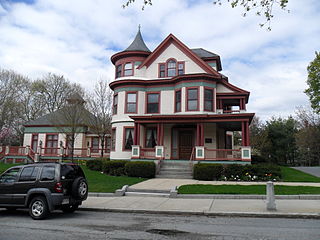
Montvale is a residential historic district in northwestern Worcester, Massachusetts. It is a portion of a subdivision laid out in 1897 on the estate of Jared Whitman, Jr., whose property contained a single house, now 246 Salisbury Street. The central portion of this house was built in 1851 in a conventional Greek Revival style, and was expanded with the addition of side wings by the developers of the 1897 subdivision, H. Ballard and M. O. Wheelock.

The Centre Village Historic District encompasses the historic central business district of Southbridge, Massachusetts. The district includes properties on Main Street, roughly between Elm and Goddard Streets. The central area represents a fairly well preserved Late Victorian commercial center. It was added to the National Register of Historic Places in 1979.

Stephen Carpenter Earle was an architect who designed a number of buildings in Massachusetts and Connecticut that were built in the late 19th century, with many in Worcester, Massachusetts. He trained in the office of Calvert Vaux in New York City. He worked for a time in partnership with James E. Fuller, under the firm "Earle & Fuller". In 1891, he formed a partnership with Vermont architect Clellan W. Fisher under the name "Earle & Fisher".

The Webster Municipal Buildings Historic District encompasses a collection of Colonial Revival municipal buildings in the center of Webster, Massachusetts, along with a collection of military memorials on the grounds of the town hall. The historic district was listed on the National Register of Historic Places in 2012.

The Charlestown Main Street Historic District encompasses the historic heart of Charlestown, New Hampshire. It is located along Main Street, roughly between Lower Landing Road and Bridge Street, and encapsulates more than two hundred years of the town's history. The district was listed on the National Register of Historic Places in 1987.

The Southborough Center Historic District encompasses a historically significant portion of the town center of Southborough, Massachusetts. It extends from the Fay School grounds in the west, along Main Street to the railroad crossing east of Lanisquama Road. The area has been the town center since its founding in 1727, and now houses a diversity of 19th and early 20th-century architecture. The district was added to the National Register of Historic Places in 1990.


