Chelsea station (MBTA)

Last updated

Chelsea
MBTA route SL3 buses at Chelsea station, July 2021.jpg
Silver Line buses at Chelsea station in July 2021
General information
Location174 Everett Avenue at Mystic Mall
Chelsea, Massachusetts
Coordinates 42°23′48″N71°02′26″W / 42.396762°N 71.040425°W / 42.396762; -71.040425
Line(s) Eastern Route
Silver Line busway
Platforms2 side platforms (Silver Line)
2 side platforms (commuter rail)
Tracks2 (commuter rail)
ConnectionsAiga bus trans.svg MBTA bus: 112,  114
Construction
ParkingNo [1]
Bicycle facilitiesCovered racks [1]
AccessibleYes
Other information
Fare zone1A (commuter rail)
History
OpenedApril 21, 2018 (Silver Line)
November 15, 2021 (commuter rail)
Services
Preceding station MBTA.svg MBTA Following station
Terminus Silver Line
SL3
Bellingham Square
North Station
Terminus
Newburyport/​Rockport Line River Works
Location
Chelsea station (MBTA)

Chelsea station is a Massachusetts Bay Transportation Authority (MBTA) intermodal transit station located adjacent to the Mystic Mall in Chelsea, Massachusetts. It is the terminus of the SL3 route of the MBTA Silver Line bus rapid transit (BRT) network, and is served by the Newburyport/Rockport Line of the MBTA Commuter Rail. The accessible station has a loop with two small platforms for the Silver Line, and two full-length side platforms for commuter rail trains.

Contents

East Everett station, located near the modern Chelsea station, was served by the Boston and Maine Railroad and predecessor Eastern Railroad from 1880 until around 1950. Prior to its 2010 cancellation, the Urban Ring Project planned for a circumferential BRT line with a stop at Mystic Mall. Planning continued for the Chelsea segment; a Silver Line extension to Mystic Mall with a new commuter rail station was announced in 2013. Construction began in 2015, and SL3 service to Chelsea station began on April 21, 2018. Commuter rail service began in 2021, replacing the previous station to the east.

Station layout

A commuter rail train at the station in 2023 Inbound train leaving Chelsea station, December 2023.JPG
A commuter rail train at the station in 2023

The station is located west of Everett Avenue in the west part of Chelsea, behind the Mystic Mall shopping center. Two 800-foot-long (240 m) high-level side platforms serve the two tracks of the Newburyport/Rockport Line, which runs roughly east–west at the station site. Canopies cover the east ends and portions of the centers of the platforms. Ramps lead to the Everett Avenue grade crossing from the east ends of the platforms, and to the Third Street crossing from the west ends. The Silver Line busway runs along the south side of the commuter rail tracks, crossing Everett Avenue at grade. A balloon loop is located west of Everett Avenue; 12-by-60-foot (3.7 m × 18.3 m) bus platforms with concrete canopies are located on both sides of the loop. The station is accessible on both modes. [2] MBTA bus local routes 112  and  114 stop at Mystic Mall near the station. [3]

History

East Everett station

Sanborn Fire Insurance Map from Everett, Middlesex County, Massachusetts. LOC sanborn03725 002-15.jpg
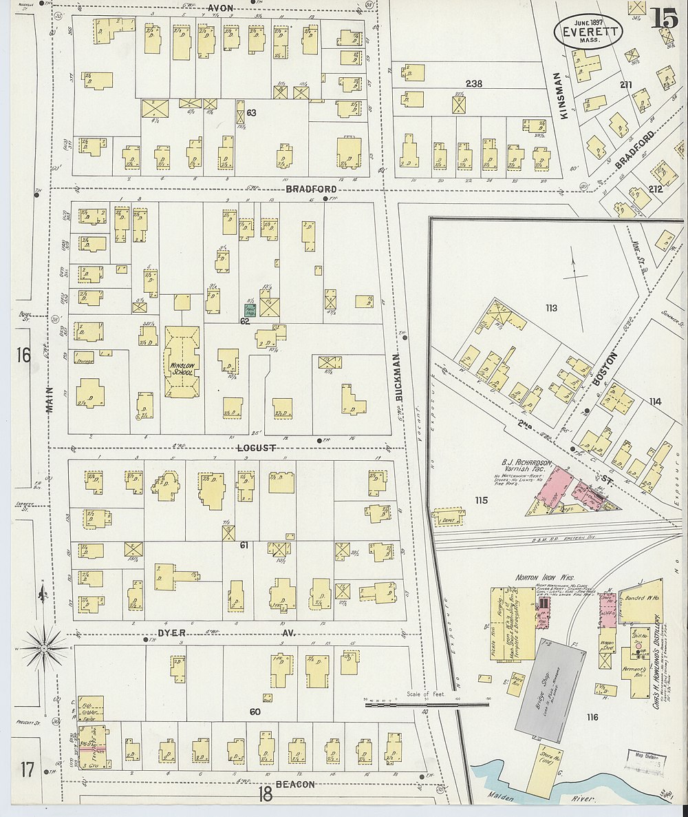
East Everett station (left) on an 1897 Sanborn map

The freight-only Grand Junction Railroad opened through Everett and Chelsea in 1852 to serve the East Boston docks. [4] :336 On April 10, 1854, the Eastern Railroad opened a line from Revere to Boston, with trackage rights over the Grand Junction from Chelsea to Somerville. This replaced the Eastern's 1838-built mainline from Revere to East Boston – which required a ferry connection to reach downtown Boston – as the railroad's primary Boston entry. In 1868, the Eastern built its own tracks on the north side of the Grand Junction tracks. [5]

The Eastern Railroad opened East Everett station in 1880. Located at the end of Boston Street just west of 2nd Street, about 13 mile (0.5 km) west of the modern station, it served residential areas to the southeast. The one-story wooden station building was constructed by nearby property owners at a cost of $1,000 (equivalent to $27,000in 2023). [6] [7] [8] The Eastern Railroad was acquired by the Boston and Maine Railroad (B&M) in 1885. [5]

Streetcars and later automobiles cut heavily into the profitability of local commuter rail service; the B&M closed the station building in 1932, though some trains continued to stop. [9] [10] The building was demolished around 1933. [11] The stop was served by only one weekday-only round trip by 1946, and was abandoned entirely by 1952. [12] [13] The remaining local stops on the line south of Lynn were closed in 1958. [5] [14]

The Massachusetts Bay Transportation Authority (MBTA) began subsidizing remaining B&M service on the line in 1965; it became the Newburyport/Rockport Line of the MBTA Commuter Rail system. [5] On December 27, 1966, an outbound Budd RDC struck an oil tanker truck at the 2nd Street grade crossing, killing 13 people. [4] :317 The residential neighborhood around 2nd Street, already planned for urban renewal, was destroyed by the Great Chelsea fire of 1973; it was replaced by industry and the Mystic Mall. [15] The Grand Junction tracks in Chelsea were largely unused after the Chelsea Creek bridge burned in 1955. In 2002, CSX Transportation began the process of abandoning the Grand Junction from 2nd Street through Chelsea to East Boston; the proceedings were delayed by negotiations with the city of Chelsea to acquire the right-of-way. [16] [17]

MBTA station

The Silver Line station under construction in 2017 Shelters and loop under construction at Chelsea station, June 2017.JPG
The Silver Line station under construction in 2017

Mystic Mall was a proposed stop on the Urban Ring Project – a planned circumferential bus rapid transit (BRT) line designed to connect the current radial MBTA rail lines. [18] Under draft plans released in 2008, a dedicated busway was to be built using the disused Grand Junction right-of-way, paralleling the active commuter rail tracks through Everett and Chelsea. Buses would have left the busway to access new surface-level BRT platforms on Everett Street and Spruce Street. The Chelsea commuter rail station would have been rebuilt at its existing site. [19] The project was shelved in January 2010 due to high costs. [20] That June, the Massachusetts Department of Transportation (MassDOT) purchased the disused Grand Junction right-of-way from 2nd Street to East Boston, to be land banked for future transportation use. [16] [4] :337 Planning for some smaller corridors continued; the Chelsea–South Boston section was given high priority because Chelsea was densely populated yet underserved by transit. [21] A 2011 state study analyzed potential Chelsea transit improvements, including a Silver Line branch or improvements to the route 112 bus. The Silver Line alternatives terminated at the Chelsea commuter rail station or Bellingham Square and did not serve the Mystic Mall area. [22]

In March 2013, the MBTA began studying a possible extension of the Silver Line to Chelsea via a newly constructed bypass road in East Boston. Three alternatives were discussed for the Chelsea section. One would run up the disused section of the Grand Junction Railroad right-of-way from Eastern Avenue to Chelsea station with stops at Eastern Avenue, Highland/Box District, the existing Chelsea station, and Mystic Mall. The second alignment would follow the Grand Junction to just short of Bellingham Square, then diverge onto surface roads to the square. The third alignment would run largely on surface streets, serving two stops on Central Avenue and four stops along a loop serving the existing Chelsea station and the MGH Chelsea healthcare center near Mystic Mall. [23] In September 2013, the MBTA indicated that it would pursue the first alternative despite potential issues with bridge clearances and rebuilding Chelsea station. [24]

A train passing the nearly-complete platforms in July 2021 Outbound train passing Chelsea station construction, July 2021.JPG
A train passing the nearly-complete platforms in July 2021

On October 30, 2013, MassDOT announced $82.5 million in state funding for construction of a modified version of the first alternative. A new $20 million Chelsea commuter rail station would be constructed at the Mystic Mall busway terminus to replace the existing station. This new station would make the commuter rail station fully accessible, with longer platforms so that trains would not block grade crossings while stopped. The Silver Line would have a new Bellingham Square stop at the old commuter rail station location. Service was expected to begin in late 2015. [25] The Environmental Impact Report was issued in March 2014. [26] A $33.8 million construction contract was approved in September 2014, and construction began in March 2015. [27] [28] [29] By June 2017, opening had been pushed back to April 2018. [30] Silver Line service to Chelsea on the SL3 route began on April 21, 2018. [31]

The MBTA opened bidding for the contract to construct the new commuter rail station (which also includes installation of several nearby traffic signals and demolition of the existing station) in February 2019, with an expected cost of $26.7 million. [32] A $32.4 million contract was awarded in April 2019, with completion then expected in late 2021. [33] Construction of the project (which has a total cost of $37.7 million) began in August 2019. [34] The supports for the outbound platform were completed by April 2020, and the platforms were installed that August. [35] [36] The station reached 70% completion in March 2021. [37] It opened on November 15, 2021, replacing the commuter rail platforms at Bellingham Square (which remains a Silver Line stop). [38] A formal ribbon-cutting ceremony was held on December 15. [39] Service on the inner portion of the Newburyport/Rockport Line was suspended for several periods in March–September 2022 to accommodate signal work on the line. [40]

Related Research Articles

<span class="mw-page-title-main">Silver Line (MBTA)</span> Bus rapid transit system in Massachusetts, US

The Silver Line is a system of bus routes in Boston and Chelsea, Massachusetts, operated by the Massachusetts Bay Transportation Authority (MBTA). It is operated as part of the MBTA bus system, but branded as bus rapid transit (BRT) as part of the MBTA subway system. Six routes are operated as part of two disconnected corridors. As of 2019, weekday ridership on the Silver Line was 39,000.

<span class="mw-page-title-main">Airport station (MBTA)</span> Rapid transit station in Boston, Massachusetts, US

Airport station is a rapid transit station in Boston, Massachusetts. It serves the MBTA Blue Line and the SL3 branch of the Silver Line. It is located in East Boston under the interchange between Interstate 90 and Massachusetts Route 1A. The station provides one of two mass transit connections to the nearby Logan International Airport, as well as serving local residents in East Boston. Shuttle buses connect the station with the airport terminals and other facilities.

<span class="mw-page-title-main">Porter station</span> Transit station in Cambridge, Massachusetts, US

Porter station is a Massachusetts Bay Transportation Authority (MBTA) transit station in Cambridge, Massachusetts. It serves the Red Line rapid transit line, the MBTA Commuter Rail Fitchburg Line, and several MBTA bus lines. Located at Porter Square at the intersection of Massachusetts and Somerville Avenues, the station provides rapid transit access to northern Cambridge and the western portions of Somerville. Porter is 14 minutes from Park Street on the Red Line, and about 10 minutes from North Station on commuter rail trains. Several local MBTA bus routes also stop at the station.

<span class="mw-page-title-main">JFK/UMass station</span> Transit station in Boston, Massachusetts, US

JFK/UMass station is a Massachusetts Bay Transportation Authority (MBTA) intermodal transfer station, located adjacent to the Columbia Point area of Dorchester, Boston, Massachusetts. It is served by the rapid transit Red Line; the Greenbush Line, Kingston/Plymouth Line, and Middleborough/Lakeville Line of the MBTA Commuter Rail system, and three MBTA bus routes. The station is named for the John F. Kennedy Presidential Library and Museum and the University of Massachusetts Boston, both located nearby on Columbia Point.

<span class="mw-page-title-main">Wellington station (MBTA)</span> Rapid transit station in Medford, Massachusetts, US

Wellington station is a Massachusetts Bay Transportation Authority (MBTA) Orange Line rapid transit station in Medford, Massachusetts, near the border of Everett. It is located on the Revere Beach Parkway, slightly east of its intersection with Route 28. Wellington functions as a park and ride with more than 1,300 spaces, and a bus hub with eight routes terminating at the station. The Station Landing development, connected to the station by an overhead walkway, includes residential and retail buildings and additional parking. Wellington Carhouse, the primary repair and maintenance facility for the Orange Line, is located adjacent to the station.

<span class="mw-page-title-main">MBTA bus</span> Greater Boston bus network

The Massachusetts Bay Transportation Authority (MBTA) operates 152 bus routes in the Greater Boston area. The MBTA has a policy objective to provide transit service within walking distance for all residents living in areas with population densities greater than 5,000 inhabitants per square mile (1,900/km2) within the MBTA's service district. Much of this service is provided by bus. In 2023, the system had a ridership of 91,459,700, or about 303,300 per weekday as of the fourth quarter of 2023.

<span class="mw-page-title-main">Malden Center station</span> Transit station in Malden, Massachusetts, US

Malden Center station is a Massachusetts Bay Transportation Authority (MBTA) intermodal transit station in Malden, Massachusetts. Located on an elevated grade above Pleasant Street in downtown Malden, it serves the rapid transit Orange Line and the MBTA Commuter Rail Haverhill Line. The station has one island platform for the two Orange Line tracks and a single side platform for the single commuter rail track. Two busways are used by 12 MBTA bus routes.

The Grand Junction Railroad is an 8.55-mile (13.76 km) long railroad in the Boston, Massachusetts, area, connecting the railroads heading west and north from Boston. The line is notable for its railroad bridge over the Charles River that passes under the Boston University Bridge between Boston and Cambridge, Massachusetts.

<span class="mw-page-title-main">Sullivan Square station</span> Rapid transit station in Boston, Massachusetts, US

Sullivan Square station is a rapid transit station on the MBTA subway Orange Line, located adjacent to Sullivan Square in the Charlestown neighborhood of Boston, Massachusetts. It is a major transfer point for MBTA bus service, with 12 routes using a two-level busway. The station has two island platforms serving the two active Orange Line tracks plus an unused third track. The Haverhill Line and Newburyport/Rockport Line pass through the station on separate tracks but do not stop.

The Urban Ring was a proposed project of the Massachusetts Bay Transportation Authority and the Massachusetts Department of Transportation, to develop new public transportation routes that would provide improved circumferential connections among many existing transit lines that project radially from downtown Boston. The Urban Ring Corridor is located roughly one to two miles from downtown Boston, passing through the Massachusetts cities of Boston, Chelsea, Everett, Medford, Somerville, Cambridge, and Brookline. The project was expected to convert 41,500 car trips to transit trips daily.

<span class="mw-page-title-main">Newburyport/Rockport Line</span> Commuter rail service in Massachusetts, US

The Newburyport/Rockport Line is a branch of the MBTA Commuter Rail system, running northeast from downtown Boston, Massachusetts towards Cape Ann and the Merrimack Valley, serving the North Shore. The first leg, operating via the Eastern Route of the former Boston and Maine Railroad, serves Chelsea, Lynn, Swampscott, Salem, and Beverly. From there, a northern branch continues via the Eastern Route to serve Hamilton, Ipswich, Rowley, and Newburyport, while other trains operate east from Beverly via the Gloucester Branch, serving Manchester, Gloucester, and Rockport. A bicycle coach is offered on the Rockport branch during the summer. With over 11,000 daily riders in October 2022, the line is the second-busiest on the system.

<span class="mw-page-title-main">Providence/Stoughton Line</span> Line of the Boston MBTA Commuter Rail system

The Providence/Stoughton Line is an MBTA Commuter Rail service in Massachusetts and Rhode Island, primarily serving the southwestern suburbs of Boston. Most service runs entirely on the Northeast Corridor between South Station in Boston and Providence station or Wickford Junction station in Rhode Island, while the Stoughton Branch splits at Canton Junction and terminates at Stoughton. It is the longest MBTA Commuter Rail line, and the only one that operates outside Massachusetts. The line is the busiest on the MBTA Commuter Rail system, with 17,648 daily boardings in an October 2022 count.

<span class="mw-page-title-main">Lansdowne station (MBTA)</span> Railway station in Boston, Massachusetts, US

Lansdowne station is an MBTA Commuter Rail station in Boston, Massachusetts. It serves the Framingham/Worcester Line. Lansdowne is located next to the Massachusetts Turnpike in the Fenway–Kenmore neighborhood near Kenmore Square, below grade between Beacon Street and Brookline Avenue.

<span class="mw-page-title-main">Bellingham Square station</span> Bus rapid transit station in Chelsea, Massachusetts, US

Bellingham Square station is a Massachusetts Bay Transportation Authority (MBTA) Silver Line bus rapid transit (BRT) station located near Bellingham Square slightly north of downtown Chelsea, Massachusetts. The station has two accessible side platforms for buses on the SL3 route. The Boston and Maine Railroad and predecessor Eastern Railroad served Chelsea station at the same location from the mid-1850s to 1958. The MBTA opened Chelsea station on the Newburyport/Rockport Line in 1985. Prior to its 2010 cancellation, the Urban Ring Project planned for a circumferential BRT line with a stop at Mystic Mall. Planning continued for the Chelsea segment; a Silver Line extension to Mystic Mall was announced in 2013. Construction began in 2015, and SL3 service to the renamed Bellingham Square station began on April 21, 2018. Commuter rail service moved to the newly constructed Chelsea station on November 15, 2021.

<span class="mw-page-title-main">Lynn station</span> MBTA rail station in Lynn, Massachusetts, US

Lynn station is an intermodal transit station in downtown Lynn, Massachusetts. It is a station on the MBTA Commuter Rail Newburyport/Rockport Line and a hub for the MBTA bus system. The rail station and parking garage temporarily closed on October 1, 2022, pending a reconstruction project, while the busway remained open. Interim platforms nearby opened in December 2023.

<span class="mw-page-title-main">Boston University Central station</span> Light rail station in Boston, Massachusetts, US

Boston University Central station is a surface-level light rail station on the MBTA Green Line B branch, located the center median of Commonwealth Avenue west of St. Marys Street in Boston, Massachusetts, surrounded by the Boston University campus. It consists of two side platforms, which serve the B branch's two tracks. The station is accessible, with raised platforms to allow level boarding onto low-floor trams and a high platform on the inbound side to serve high-floor light rail vehicles.

<span class="mw-page-title-main">Newmarket station (MBTA)</span> Train station in Boston, Massachusetts, US

Newmarket station is an MBTA Commuter Rail station in Boston, Massachusetts. It serves the Fairmount Line and a small number of Franklin/Foxboro Line trains. It is located off Massachusetts Avenue at Newmarket Square in the Dorchester neighborhood. The station has two 800-foot (240 m) high-level platforms and sloping walkways connecting it to Massachusetts Avenue. Originally planned to be in service in 2011, it opened on July 1, 2013, along with Four Corners/Geneva station.

<span class="mw-page-title-main">Box District station</span> Bus rapid transit station in Chelsea, Massachusetts

Box District station is a bus rapid transit station on the Massachusetts Bay Transportation Authority (MBTA) Silver Line system, located in Chelsea, Massachusetts. The accessible station has two side platforms under an arched canopy, with street access from Broadway and from Highland Street. Plans for the Urban Ring Project called for a busway along the former Grand Junction Branch, but without a station in the Box District neighborhood. After the Urban Ring was cancelled in 2010, new plans for a busway with a Box District stop were announced in 2013. Construction began in 2015, with route SL3 service beginning on April 21, 2018.

<span class="mw-page-title-main">Eastern Avenue station</span> Bus rapid transit station in Chelsea, Massachusetts, US

Eastern Avenue station is a bus rapid transit station on the Massachusetts Bay Transportation Authority (MBTA) Silver Line system, located in Chelsea, Massachusetts near Chelsea Creek. The accessible station has two side platforms, with street access from Eastern Avenue and Central Avenue. Plans for the Urban Ring Project called for a busway along the former Grand Junction Branch, but with a station further north at Griffin Way. After the Urban Ring was cancelled in 2010, new plans for a busway with an Eastern Avenue stop were announced in 2013. Construction began in 2015, with route SL3 service beginning on April 21, 2018.

References

  1. 1 2 "Chelsea station". Massachusetts Bay Transportation Authority . Retrieved January 14, 2024.
  2. "Silver Line Gateway: Extension of Silver Line Bus Rapid Transit (BRT) to Chelsea and East Boston: Public Informational Meeting: Chelsea, MA" (PDF). Massachusetts Department of Transportation. August 18, 2014. pp. 7, 28. Archived from the original (PDF) on March 31, 2018.
  3. "2023–24 System Map". Massachusetts Bay Transportation Authority. December 17, 2023.
  4. 1 2 3 Karr, Ronald Dale (2017). The Rail Lines of Southern New England (2 ed.). Branch Line Press. ISBN   978-0-942147-12-4.
  5. 1 2 3 4 Humphrey, Thomas J.; Clark, Norton D. (1985). Boston's Commuter Rail: The First 150 Years. Boston Street Railway Association. pp. 75–77. ISBN   978-0-685-41294-7.
  6. "A New Railway Station at East Everett". Boston Daily Globe. December 22, 1880. p. 1 via Newspapers.com. Open Access logo PLoS transparent.svg
  7. "East Everett station, Everett, Mass". Boston & Maine Railroad Historical Society. January 27, 2014 via Flickr.
  8. Sanborn Fire Insurance Map from Everett, Middlesex County, Massachusetts. Sanborn Map Company. 1910. Plate 50.
  9. "Boston & Maine asks right to abandon three stations". Boston Daily Globe. April 21, 1932. p. 3 via Newspapers.com. Open Access logo PLoS transparent.svg
  10. "B. & M. is granted right to abandon four stations". Boston Daily Globe. June 25, 1932. p. 2 via Newspapers.com. Open Access logo PLoS transparent.svg
  11. "How would you like to live in a railroad station". Boston Globe. July 15, 1933. p. 3 via Newspapers.com. Open Access logo PLoS transparent.svg
  12. Northern New England Travel Guide. Boston and Maine Railroad. April 28, 1946. pp. 14–15 via Wikimedia Commons.
  13. Passenger Train Schedules, Boston and Maine Railroad, April 27, 1952, pp. 14, 15 via Wikimedia Commons
  14. "Drastic Service Cuts Approved on Five B.& M. Divisions". Daily Boston Globe. April 19, 1958. p. 11 via Newspapers.com. Open Access logo PLoS transparent.svg
  15. Concetta Coreth, Lake (April 2011). Chelsea Under Fire (thesis) (Thesis). Boston College Department of History. p. 52. hdl:2345/1998.
  16. 1 2 Fay, Spofford & Thorndike (June 2011). "CSX ROW Multi-Use Path Feasibility/Conceptual Design Study" (PDF). City of Chelsea, MA. p. 43. Archived from the original (PDF) on December 20, 2016.
  17. New York Central Lines, LLC; CSX Transportation, Inc. (March 8, 2002). "Docket No. AB-565 (Sub-No. 7X)" (PDF). Surface Transportation Board. Archived from the original (PDF) on November 2, 2021.
  18. "Urban Ring Phase 2 FACT SHEET" (PDF). Massachusetts Executive Office of Transportation. January 2009. Archived from the original (PDF) on July 8, 2011.
  19. "The Urban Ring Phase 2: Revised Draft Environmental Impact Report/Statement" (PDF). Massachusetts Executive Office of Transportation. November 2008. Archived from the original (PDF) on May 14, 2017.
  20. Mullan, Jeffery B. (January 22, 2010). "Re: Urban Ring Phase 2, EOEEA #12565" (PDF). Massachusetts Executive Office of Energy and Environmental Affairs. Archived from the original (PDF) on March 23, 2020.
  21. Quackenbush, Karl H. (November 1, 2012). "Work Program for: MBTA Silver Line to Chelsea: Alternatives Analysis, Phase 2" (PDF). Central Transportation Planning Staff.
  22. Peterson, Scott. "Analysis of Silver Line Service to Airport Station and Chelsea" (PDF). Central Transportation Planning Staff. Archived from the original (PDF) on August 20, 2015.
  23. "Silver Line Gateway Alternatives Analysis" (PDF). Massachusetts Department of Transportation. June 19, 2013. Archived from the original (PDF) on August 26, 2015.
  24. Hamwey, Scott (September 18, 2013). "Silver Line Gateway Alternatives Analysis: Public Meeting – September 18, 2013" (PDF). Massachusetts Department of Transportation. Archived from the original (PDF) on August 20, 2015.
  25. "Governor Patrick Announces MBTA Silver Line Expansion" (Press release). Massachusetts Department of Transportation. October 30, 2013. Archived from the original on November 5, 2013. Retrieved March 15, 2018.
  26. Silver Line Gateway Service to Chelsea, East Boston & the Blue Line: Single Environmental Impact Report (Single EIR): EEA # 15124 (PDF). Massachusetts Department of Transportation. March 31, 2014. Archived from the original (PDF) on October 23, 2014.
  27. "MBTA Silver Line to Chelsea Approved" (Press release). Massachusetts Department of Transportation. September 17, 2014. Archived from the original on March 26, 2018. Retrieved March 17, 2018.
  28. "Silver Line Gateway" (PDF). Massachusetts Department of Transportation. June 5, 2017. p. 3.
  29. "Silver Line Gateway Project Overview". Massachusetts Department of Transportation. March 2018. Archived from the original on March 15, 2018.
  30. Vaccaro, Adam (June 6, 2017). "Silver Line service to Chelsea to begin next spring". Boston Globe. Archived from the original on June 6, 2017.
  31. "Silver Line 3 Update" (PDF). Massachusetts Bay Transportation Authority. March 12, 2018.
  32. "Notice to Bidders" (PDF). Massachusetts Bay Transportation Authority. February 8, 2019. Archived (PDF) from the original on February 13, 2019. Retrieved February 13, 2019.
  33. "MBTA Board Awards Contract for New Commuter Rail Station in Chelsea" (Press release). Massachusetts Bay Transportation Authority. April 29, 2019.
  34. "Baker-Polito Administration Celebrates Beginning of Chelsea Commuter Rail Construction" (Press release). Massachusetts Department of Transportation. September 16, 2019. Archived from the original on September 24, 2019. Retrieved September 18, 2019.
  35. "Platform Work Continues at Chelsea Commuter Rail Station" (Press release). Massachusetts Bay Transportation Authority. May 4, 2020.
  36. "Train Platform Work Progressing at Chelsea Commuter Rail Station" (Press release). Massachusetts Bay Transportation Authority. August 13, 2020.
  37. "Report from the General Manager" (PDF). Massachusetts Bay Transportation Authority. March 29, 2021. p. 15.
  38. "New Chelsea Commuter Rail Station Opens November 15" (Press release). Massachusetts Bay Transportation Authority. November 1, 2021.
  39. "MBTA Celebrates Completion of Chelsea Commuter Rail Station" (Press release). Massachusetts Bay Transportation Authority. December 15, 2021.
  40. Belcher, Jonathan. "Changes to Transit Service in the MBTA district" (PDF). Boston Street Railway Association.

Commons-logo.svg Media related to Chelsea station (MBTA) at Wikimedia Commons